Stop 38 was located at Newbury's Kiwanis Lake, one of many small lakes along the line. Prior to the building of the C & E this area was mostly inaccessible wilderness. In 1913 a group of businessmen formed the Tuxedo Land Company, which purchased the land around the lake and divided it into small lots. The intent was to allow city dwellers to purchase these lots and build cabins for weekend outings and summer vacations.
Aided by the easy access provided by the electric railway, the small community grew rapidly and at one time had two C & E stops and its own dance hall. It is also rumored that there was at least one 'speakeasy' located here during the prohibition era of the 1920s. After the demise of the interurban many of the cabins were boarded up as the condition of the local roads made access to the area difficult at best. The increasing popularity of the automobile eventually resulted in better paved roads in the county and many of the original cabins were rebuilt as homes intended for year-round residence.
The roads of the Kiwanis Lake Community were turned over to Geauga County ownership in the 1960s. Many were paved with gravel, although several were eventually eliminated. Today the small community boasts over 100 permanent residences surrounding the picturesque lake. Portions of the roadbed remain intact and were used as a bridal trail in recent years.
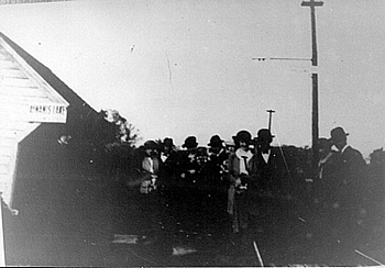
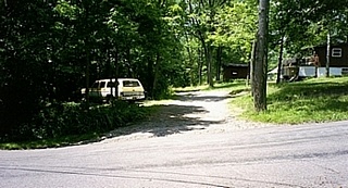
The first photograph in this series shows a group posing in front of the C & E's Kiwanis Lake station. At that time the area had been logged off and the lake was surrounded by lawns. The additional photographs were taken at the same location nearly 100 years later. The vehicle in the second photograph is approximately at the location of the station and the roadbed is clearly visible. The view is looking west from View Drive.
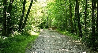
The third photograph shows the roadbed heading east from View Drive towards Hickory Lake, where it curves to the south and heads for Punderson Lake on its way to Burton. The last photograph, taken several hundred feet west of View Drive, shows the lake in a typical Geauga County winter. The roadbed is visible in the foreground just beyond the tree line. The land surrounding the lake has returned to forest and is now community property.
|