


As freight traffic boomed during and following World War II, Southern Pacific faced a problem of increasing congestion in the Los Angeles area, where many trains originated and terminated, and through which all through trains had to pass on their way between points north via the San Joaquin Valley and points east via Yuma and El Paso. If this through traffic could bypass the immediate area around Los Angeles, not only would it reach its destination sooner, but also there would be that much less congestion in the Los Angeles region.
So, in the mid-1950's, SP began discussions with the Santa Fe, proposing to build a 46 mile line from Palmdale to Summit, where it would connect with the Santa Fe. SP could then operate over AT&SF rails from Summit to Colton, and Santa Fe, in turn, could operate its trains between northern and southern California over the new SP line to Palmdale. From there, the Santa Fe would be allowed to use the existing SP track from Palmdale to Mojave, where AT&SF trackage rights already began on the SP to cross the Tehachapi Mountains to Kern Junction, just east of Bakersfield.
Such a joint agreement would have saved the Santa Fe's trains between northern and southern California from having to go to Barstow and "change ends" (reverse their direction of travel) and would have speeded up their schedules considerably. When it became evident that the SP and the AT&SF could not reach a satisfactory agreement on this proposal, the SP proposed to give up the idea of a joint-trackage arrangement and instead to construct its own line all the way from Palmdale via Cajon Pass to a connection with its Sunset Route just west of Colton. The new line, known as the Palmdale-Colton Cutoff, would be 78 miles long and cost $22 million.
The ruling grade would be 2.2 percent, the same as the Santa Fe's, and maximum curvature would be six degrees compared to Santa Fe's maximum (at that time) of 10 degrees, and the entire line would be laid with continuous welded rail.
Construction started on April 5, 1966, with the contractor, Vinnell Corporation, doing the grading, placing of culverts, construction of bridges, etc. using three separate "spreads" of equipment, starting at Palmdale, the Barstow Freeway north of Summit and Highland Avenue (between San Bernardino and Rialto), respectively.
When the grading was far enough along, SP forces began laying track, starting from the Palmdale end. Toward the end of tracklaying, a gang started laying track northward from the Colton end of the line, and the final spike was driven just north of the Baseline Street overpass on June 29, 1967.
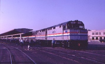
Dedication ceremonies were held near the Palmdale end of the line on July 11, 1967 and a freight train departed for Colton over the new line. However, the first revenue freight train ran two days earlier on July 9, with the same unit, 8748, on the point.
The first siding was located right out of Palmdale and was designated Palmdale No. 2. Next came Wash, 21 miles from Palmdale, then Hiland, adjacent to Summit on the Santa Fe, then Canyon, between Pine Lodge and Sullivan's Curve, then Dike, opposite Devore on the Santa Fe, and finally Slover, just north of the junction with the Sunset Route, which was designated West Colton, and where, a few years later, SP would build a large ultra-modern hump yard.
Surprisingly, there was no block signal system or CTC on the new line, and operation was by train orders. In a couple of years, a modern house trailer was placed at Hiland on the spot where the "Descanso" used to be and an operator was stationed there to expedite traffic movements. Then in 1974, the SP placed a caboose beside the track of both Hiland and Dike for track order offices and they were manned around the clock. But within a few years, CTC was installed on the entire length of the Cutoff and the operators at Dike and Hiland were eliminated and the cabooses and trailer were removed.
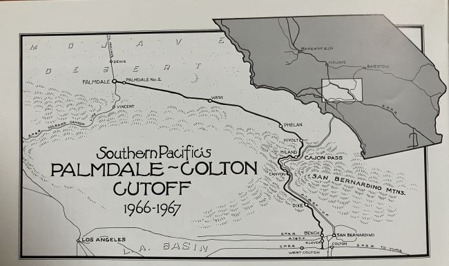
A diagram of Southern Pacific's Palmdale-Colton Cutoff from "Chard Walker's Cajon - Rail Passage to the Pacific". The above historical information also taken from this source.
Pacific Railroad Society's ExcursionThis excursion was to be the first passenger train over the Palmdale Cutoff to Mojave, where the train would be turned for our return. Routing was the Sunset's route east to West Colton Yard and join the Cutoff there.
It was a bright Sunday morning as my friend Cindy Piehl and I drove to Los Angeles Union Station for this excursion utilizing the equipment from the Sunset Limited pool that laid over in Los Angeles, since that train is tri- weekly. We parked and entered the grand building, walking to the gate where we met the rest of the passengers then all of us went down the long tunnel and up the ramp to the track where we found our Santa Fe hi-level coach in this fourteen-car consist. After settling in, the excursion departed on the advertised and made its way to Mission Tower, where we crossed the Los Angeles River to the route that travelled in the middle of the San Bernardino Freeway. While this was the Sunset Limited's normal route, its late evening departure meant that regular commuters were not aware that passenger trains used this route. As such, our passage created many strange and surprised looks on the drivers' faces.
We made great time through here and all too soon, we were curving on the high viaduct off the freeway to reach the mainline at El Monte then crossed the San Gabriel River before passing the north side of SP's City of Industry Yard and proceeded east on the Sunset Route through Walnut to Pomona, where we stopped briefly to pick up some more passengers. Now in the San Bernardino Valley, we cruised through Montclair and Ontario, by the airport and through Kaiser Yard which served the large Kaiser Steel plant north of the freeway. We paralleled Interstate 10 to West Colton Yard, where we were routed around the south side so everyone had an opportunity to see the yard, stopping long enough to add an SD40E to the point of our train as a helper. We passed the fuelling racks and the outbound yard before we made our way to the maze of switches to reach the Palmdale Cutoff.
There was an air of excitement as we passed through each of those switches and the new mileage for all aboard, the Southern Pacific crew. The train slowly climbed the short but steep grade to get over the bypass track and Interstate 10 to reach Slover siding. Many railfans were out to record the historical significance of our passage and we travelled due north the length of Slover before crossing over Santa Fe's Second District, where the west end of Santa Fe's "A" Yard was on the right. We passed Bench, the junction with the former Pacific Electric San Bernardino Line, rounded a slight "S" turn, crossed Lytle Creek Wash and climbed a hill above the homes on Duffy Street then turned to the northwest, leaving San Bernardino behind, bound for Cajon Pass.
We were now approaching the gap between the San Gabriel Mountains on the right and the San Bernardino Mountains on the left to the passage created by the San Andreas Fault called Cajon Pass as we bridged Institution Road then travelled on a fill beside a dump on the right as the tracks grew closer to those of the Santa Fe, on which Union Pacific had joint use from Riverside Junction to Daggett. We reached the east end of Dike siding, located on top of the dike of Cajon Creek and to the left on the hills was Glen Helen Regional Park. We then approached Devore and the west end of Dike, crossed Devore Road, followed by Cajon Creek Wash and ducked under Interstate 15.
Here, the canyon narrowed as we passed a location that SP crews called Skin Ranch, a nudist colony. The locomotives were really working up the grade and pacers were doing their best to keep up on old Highway 66, otherwise known as Cajon Boulevard. We were high above the Santa Fe double track main line as we passed the location of Keenbrook on that railroad before we navigated a broad sweeping curve to Blu Cut and our crossing of the San Andreas Fault. Just to the north of there, after Swarthout Canyon Road, was a sag pond called Lost Lake created by the action of the fault. The road turnout at Blu Cut was full of photographers trying for that one special picture and we were now about forty feet above the Santa Fe tracks and curved to the left, high above the location of the former campground where I once camped as a Boy Scout.
Our train was now in the narrowest part of the canyon as we neared Cajon siding on the Santa Fe, but our tracks took us directly to Sullivan's Curve with its unique rock structures. After many trips on the Santa Fe over Cajon Pass, it did not faze me that I was now on this new Southern Pacific trackage and the journey around the curve had a special excitement to it. Canyon siding started at the east end of the curve and we followed its path to its west end near where we crossed over Highway 138, then bridged Cajon Creek before passing below the Mormon Rocks to Davis Ranch, where we turned east. Ducking under Interstate 15, we crossed over the former path of Route 66 and cut through the slopes, where the Santa Fe tracks below pass through the only two tunnels on the Pass. We travelled across the slope, climbing steadily as the two Santa Fe tracks grew closer together below since they split at Cajon, then we turned to the southeast, passing underneath the high power lines through a deep cut to Hiland, the Summit of Cajon Pass and the commencement of a 9,097 foot siding. Here, our helper locomotive was cut off as it was no longer needed.
Continuing railroad west, we were high above the Summit Valley which Santa Fe follows to Victorville and points east, while we turned north onto the high desert with the ever-present Joshua Trees and passed the switch to the siding at Hivolt before turning to the northwest. Our route took us cuts and fills underneath Interstate 15 before crossing Oro Grande and Manzanita Washes and Phelan Road before reaching Phelan Siding and the train was running really well on the slightly-descending grade as we crossed Horse Canyon Wash and a few miles after, Sheep Creel Wash before we bridged the California Aqueduct and exited San Bernardino County for Los Angeles County.
We crossed over Palmdale Road, also known as California Highway, turning to the west, followed by Montaine Creek and Mescal Washes and reached Wash siding before we crossed Graham, Boulder, Grandview, Big Rock and Little Rock Washes then stopped traffic as we went over Pearblossom Highway and reached Palmdale 2 siding, the last on the Palmdale Cutoff. Turning to the right, we crossed the Sierra Highway and continued to Palmdale Junction, where the Saugus Line, the original line to Los Angeles, was reached and were now at the west end of the Palmdale Cutoff.
We turned north passing through Palmdale and crossing Sierra Highway at grade before going by the huge Lockheed plant as we reached Denis siding then train sped north through Lancaster, passing Oban siding and entering Kern County before zipping through Rosamond. Here, the train climbed Ansel Hill and reached the top at Ansel siding before descending the north side of the hill and passing Purdy Metals to east Mojave, where the Santa Fe line from Barstow joined the route for the trip over the Tehachapi Mountains.
We ducked under California Highway 14 and were lined into the yard to be turned on the wye of the Oak Creek Branch. This move was conducted very slowly and once completed, passengers were allowed to detrain as the crew prepared for the return.

Cindy and I really enjoyed ourselves on a most interesting excursion. The passengers' mood was somber and it was a quiet journey back to Los Angeles Union Station over the Palmdale Cutoff and the Sunset Route into the sunset towards home. Once back, I dropped Cindy off at her house then returned to mine.
| RETURN TO THE MAIN PAGE |


