


 |
 |
 |
|
The city streetcar was once the transportation lifeblood of most large American cities, and Portland was no exception. From its first downtown horse-drawn line in 1872, the city's streetcar network expanded throughout the city and its suburbs. In its heyday in the early 20th Century, it could boast of more than 200 miles of track. But the inroads of the automobile, aging equipment and public disinterest killed it. The last city routes closed down Feb. 28, 1950, while the remaining suburban routes disappeared Jan. 25, 1958. Even today, area construction projects often turn up old, long-buried streetcar and interurban tracks. |
 |
Now, in the 21st Century, the streetcar has returned to Portland. Portland Streetcar came about as the result of a nearly 30-year effort to return frequent transit service to some of the city's older neighborhoods. |
|
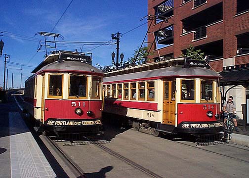
The 1972 Downtown Plan envisioned it, and in the 1990s it went from a vision to reality. The line helps reduce short, inner-city automobile trips; ease traffic and parking congestion; helps keep the air clean; and encourages additional residential, commercial and business development in the areas around which it passes. In 1991, Vintage Trolley began running between the Lloyd District and downtown Portland on Tri-Met's MAX light rail line. It used a fleet of four streetcars built by an Iowa company, Gomaco. They were replicas of the city's famed "Council Crest" cars, which had operated up into the West Hills to the end of regular streetcar operations in 1950 (two of the original "Council Crest" trolleys, along with one of the city's 1930s-vintage "Broadway" cars, survive in the collection of the Oregon Electric Railway Historical Society at Brooks, Ore.) |
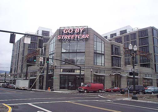
| In 1995, the City of Portland established the non-profit Portland Streetcar, Inc. to coordinate and direct new streetcar development. The first route developed was between the Nob Hill neighborhood in northwest Portland and the Portland State University campus in southwest Portland. | 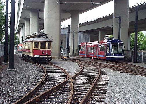 |
|
The original loop connected these neighborhoods with a route through the Pearl District, an old industrial area built around the old Spokane, Portland & Seattle (later Burlington Northern) railroad yards, which the city redeveloped into a mixed residential and commercial area; through the west end of the downtown core, where it crosses the east-west MAX light rail line, creating a hub from which riders can transfer to and from either route; and along the edge of the city's museum district in the South Park Blocks. Construction began in March 1999. Initially, it was to have looped back at SW Montgomery Street, on the edge of the PSU campus. The Portland Development Commission subsequently provided an additional $500,000 to extend the line through the campus to an new Urban Center at SW 5th Avenue and Mill Street, where it connected with the existing downtown Transit Mall and also provided a jumping-off point for future expansion. |
 |
Constructing the route began with utility relocation, followed by actual track laying, in which crews excavated a shallow trench, about one foot deep, into which they installed a framework of steel reinforcing bars. |
|
Within this framework they installed a series of steel cross-members, similar to railroad ties, onto which they attached the rails. Once the tracks were in place, concrete was poured into the trench, making the tracks flush with the surface of the street. The route shares the same operating gauge as the light rail lines, and the streetcars can run on the MAX tracks if they need to visit the Tri-Met shops for more extensive servicing or repair. However, MAX cars, due to their larger size and weight, cannot in turn operate on the streetcar route. Other crews installed the route's overhead wires through which the the streetcars get power to operate. Like the MAX lines through downtown, the route uses a single-wire transmission system. Still other crews installed the line's boarding platforms and a maintenance shop underneath I-405 at NW Marshall Street between NW 15th and 16th Avenues. |
| Infrastructure testing began in January 2001. Crews used Vintage Trolley car #514 towed by a Tri-Met utility truck equipped with a coupler adaptor, since the overhead trolley wire was not yet energized. Powered tests began in February, also with #514, as the delivery of the first Skoda car approached. | 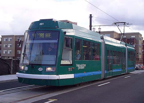 |
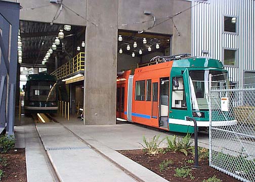
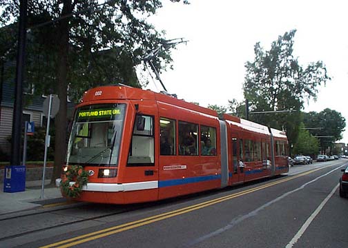
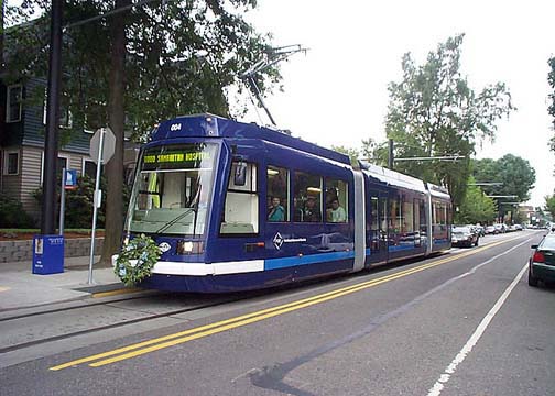
Car #001 arrived by ship in Vancouver, Wash. April 2, 2001, and was unloaded April 7. A lowboy trailer transported the car to the Marshall Street shops April 9, where it underwent cleaning and static testing. It made its first test run under power the week of April 23. All five cars of the initial order were delivered by early June, when full-scale testing for train operators began. The cars are 66 feet long and 8 feet wide, smaller than a MAX light rail car but ideal for the more restricted street running they encounter. They have seats for 30 riders and can hold up to 150 with standees. The Marshall Street maintenance facility can accommodate two of the cars at one time, with room to work overhead and underneath the cars. For more extensive servicing or repairs, the streetcar line is tied in to the MAX light rail system at SW 10th Avenue and Morrison Street, where the cars can head east to the Ruby Junction shops in Gresham or west to the Elmonica shops in Beaverton. Each car is unique in that it wears its own distinctive color scheme, with a combination of two colors. One side and one end of each car are painted in a different color, so that the same car will appear different when viewed coming and going. A blue stripe along the lower body accents the colors, and blends into a white bumper on each end. Each car also has a sponsor: these include Portland State University; Portland General Electric: Legacy Health systems; Hoyt Street Properties; Regence Blue Cross/Blue Shield; and Powell's Books, the large independent book seller whose flagship "City of Books" store straddles the streetcar line on West Burnside Street between 10th and 11th Avenues. Other organizations and businesses sponsor the stops along the line. These are simple structures consisting of a raised platform with a ramp for wheelchair and stroller access, a safety railing, a bus-style shelter, tactile strips along the platform edge, and yellow safety striping. Most are located about two blocks apart. |
 |
The original route, as laid out, loops around the Legacy Good Samaritan Hospital complex on NW Northrup Street, 23rd Avenue and Lovejoy Street. It proceeds east on Lovejoy to NW 11th Avenue, where it turns south. |
It follows 11th Avenue all the way to SW Market Street, where it turns east again. Along the way, it crosses the east-west MAX line at SW Morrison and Yamhill Streets. There is also a turnback loop at SW Market and 10th to allow trains to head back north if necessary. The line heads east on Market Street all the way to SW 5th Avenue, where it links to the downtown Portland Transit Mall, then turns south again for about a block to SW Montgomery Street. The track turns left here at SW 4th Avenue. Originally, trains pulled into the stub track, where the operator changed cab ends. The train then pulled across 5th Avenue. The track passes through the PSU Urban Center plaza, then follows SW Mill Street through the PSU campus. It turns back north again at SW 10th and Mill. From there, it heads back north to NW Northrup Street, crossing the MAX line again at SW Yamhill and Morrison. There is a short connecting track at SW 10th and Morrison to allow the streetcars and vintage trolleys to access the light rail tracks. At Northrup, the line turns west again and follows the street back to NW 23rd. |
| Portland Streetcar inaugurated service July 20, 2001 with a ceremony at the PSU Urban Plaza, followed by a streetcar parade north along the route. Celebrations also took place in each of the neighborhoods along the route. Service was provided free during the first weekend. | 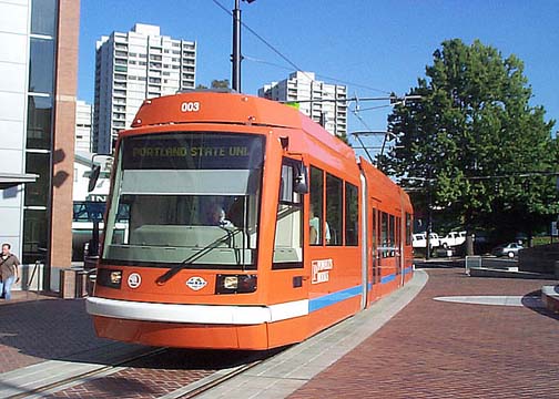 |
|
The line uses the MAX fare structure for the entire system. All regular Tri-Met tickets and passes are accepted on the trains, as well as the HOP smartcard. |
 |
The line's sixth and seventh streetcars arrived by ship at the Port of Vancouver in July 2002. Following delivery and testing, the cars entered service in August. They were purchased as an add-on to an order of three similar cars for Sound Transit's Tacoma Link streetcar line in Tacoma, Wash. |
|
All told, it cost $56.9 million to build the line, including:
|
| The agency's first expansion took the line about 3/4 of a mile south to the RiverPlace complex, starting at SW 4th Avenue and Montgomery Street. The city received about $500,000 in Federal funds for the project. Construction began in August 2003 and the line opened March 11, 2005. | 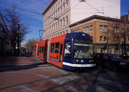 |
|
The extension followed SW 4th Avenue south to SW Harrison, where it turned east. East of Naito Parkway, it ran along a new stretch of SW Harrison, crossing Harbor Drive and ending at SW Moody. The extension added stops along SW Harrison at SW 3rd Ave., SW 1st Av. and Harbor Drive, and on SW River Parkway at SW Moody. Construction began in January 2005 to further extend this line from RiverPlace south to SW Gibbs and Moody, where the Oregon Health Sciences University (OHSU) is building new facilities in the South Waterfront District. This section opened Oct. 20, 2006. Construction on the Lowell Extension through the South Waterfront District began in August 2006. Service began on this segment Aug. 17, 2007. This 0.6 mile extension connects at SW Moody and Gibbs, follows SW Moody south to SW Lowell, and turns east on SW Lowell to SW Bond. The route loops north on SW Bond back to SW Moody at Gibbs. Planners would like to ultimately extend the line all the way to Lake Oswego. Several alignments are under consideration, including the former SP Jefferson Street Branch, which carried Red Electric interurban trains in the early 20th Century and now hosts the seasonal Willamette Shore Trolley. Construction on the East Bank project began in September 2009 with utility relocations. The 3.3-mile extension crosses the Willamette River on the Broadway Bridge and serves the Rose Quarter sports complex, the Lloyd District, the Central Eastside Industrial District, and OMSI. Service on the new began Sep. 22, 2012. At the same time, service patterns were configured into two interconnected routes. The Central Loop line followed the new east side extension and the original loop on NW 10th/11th between NW Lovejoy and SW Market. The North-South line follows the original loop between NW 23rd and PSU and the South Waterfront extension. With the opening of the MAX Orange Line to and from Milwaukie in September 2015, the Central Loop was replaced by the A Loop and the B Loop. The A Loop runs clockwise and the B Loop runs counterclockwise using portions of the west side and east side routes. The two loops share the new Tilikum Crossing bridge across the Willamette River with MAX. All TriMet MAX light rail lines provide direct connections to the Streetcar. The east-west Blue Line and Red Line cross the Streetcar route at SW Yamhill and SW Morrison at both 10th and 11th Avenues. Along with the Orange Line the Green Line to and from Clackamas Town Center and the Yellow Line to and from the Portland Expo Center cross the Streetcar route at the north and south ends of the Portland Transit Mall on 5th and 6th Avenue. In the Lloyd District, the Streetcar crosses the east-west light rail corridor on NE Grand Avenue and NE 7th Avenue. A milestone event occurred on the streetcar line June 27, 2009 with the introduction of the first American-made streetcar since the early 1950s. Car #015 was the first of six cars being built by United Streetcar, a subsidiary of Oregon Iron Works in the Portland suburb of Clackamas. The car was painted in the now-familiar Portland Streetcar pattern, but included large "Made In USA" lettering. The U.S.-built cars use the Inekon design. The table below shows the system's stops. The stations closest to the east-west MAX line are indicated by an asterisk (*). Stops adjacent to the Transit Mall are indicated by the pound symbol (#). |
|
|
| Visit the Portland Streetcar web site. |
 |
| To navigate through the site, just click on one of the links in our image map. | |
 |


