TrainWeb.org Facebook Page
B&O Photo Tour


Baltimore City Intersections
Modern day photos

Accompanying each photo below are:

Click a photo to see a larger view. Please send your comments and corrections to Steve.


Brief Background: Baltimore City Intersections

No Turn On Red

No Turn On Red
Mile: Date: Jun 2011
Ease: A View: E
Area: C IC2:
Map: Ba 34 E 12 Topographic Maps

The sign proclaims "No Turn On Red"... well, we have four red signals, and three green arrows simultaneously eastbound at Edmondson Avenue (US 40) near Poplar Grove Street. The local drivers are turning right so perhaps the sign should read "Turn On Green Only". White pavement arrows in each lane would help too.


No Turn On Red 2

No Turn On Red 2
Mile: Date: Feb 2004
Ease: B View: W
Area: C IC2:
Map: Ba 35 K 13 Topographic Maps

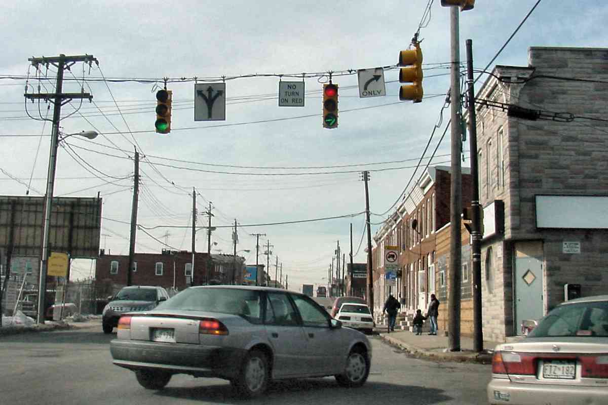
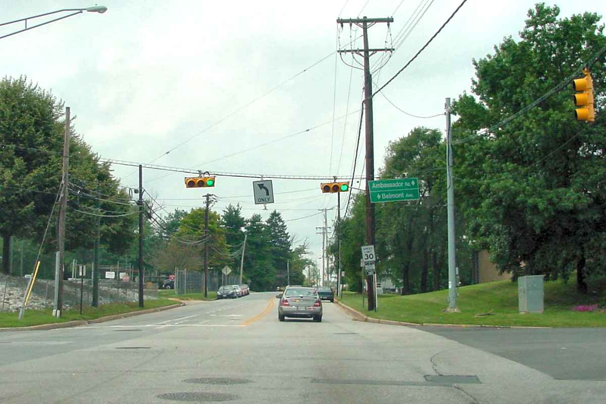
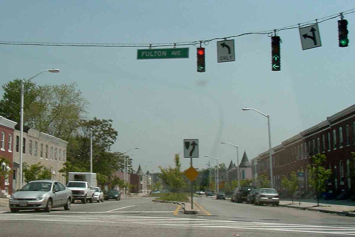
Westbound on Lombard Street at Kresson Street... another No Turn On Red sign, this time combined with red signal, green signal, and green arrow. I suppose the two signal heads are an attempt at individual lane control, but in general when a lane is turn only (as is the right lane), its traffic signal does not display red while turning is allowed.

Side note: the circular O in "Only" is the hallmark of some of the oldest Baltmore signage, likely dating to the 1950s. Newer "Only" signs employ a font with a more oval letter O, similar to the O in the "No Turn On Red" sign at left.


No Left

No Left
Mile: Date: Feb 2004
Ease: A View: W
Area: C IC2:
Map: Ba 35 F 12 Topographic Maps

Two generations of No Left turn signs grace Orleans Street west at Patterson Park Avenue. The rectangular bracket holding the older No Left sign on the right can be found at many intersections, but only a few retain their original signs. Putting the newer No Left above the left lane was a welcome improvement.

Also of note is the Eagle brand traffic signal, this one with a mismatched set of visors. In the past the Eagle, notable for its "traditional" four-way traffic signal shape, had been common in Baltimore, but only a handful survive on duty.

Link: Eagle at Traffic Signal Museum


Four Lanes

Four Lanes
Mile: Date: Sep 2004
Ease: A View: W
Area: B IC2:
Map: Ba 33 J 13 Topographic Maps

Four lanes, four signals, two in the process of changing, two staying green. I cannot think of a good reason the two right lanes should be stopped while the two lanes heading straight are allowed to proceed.


One Lane

One Lane
Mile: Date: Sep 2010
Ease: A View: E
Area: B+ IC2:
Map: Ba 35 G 5 Topographic Maps

An odd collection of signal equipment hangs over Druid Park Drive at 41st Street including oversize arrows, and mismatched (or missing) visors. Most eastbound traffic turns left onto 41st Street, and no road intersects from the right.


Stop Red

Stop Red
Mile: Date: Jun 2011
Ease: A View: SW
Area: B- IC2:
Map: Ba 33 K 6 Topographic Maps

Hmm, a Stop sign mounted on a traffic signal pole... "Yes, driver, this means you really, really need to stop at this red signal!" "Driver, stop even if the signal is green." "Stop underneath the signal?" Your guess is as good as mine. Gwynn Oak Avenue crossing Liberty Heights Avenue.

Steve Alpert posits:

    "The stop sign is only supposed to be deployed if the signals go dark. It should be folded up or covered otherwise. This appears to be an error on the part of Baltimore, though I would have to see it in person to be certain of what's going on. (Usually it's done manually by the local police agency. At least one idea I've heard of has the signs locked up by a magnet. When the power goes out, the magnet fails, and the top of the sign drops down. But then when the power comes back on, I don't know how the sign folds back up...)"


Firehouse

Firehouse
Mile: Date: Sep 2010
Ease: A View: W
Area: D- IC2:
Map: Ba 34 H 11 Topographic Maps

What is amber doing on the bottom? The parked firetruck gives away the answer. Westbound on Lafayette Avenue, the more typical amber is ahead at Gilmor Street.


Horizontal

Horizontal
Mile: Date: Aug 2003
Ease: A View: W
Area: B+ IC2:
Map: Ba 33 C 7 Topographic Maps

For better visibility beyond an I-695 bridge, signals at the intersection of Dogwood and Ambassador Roads are mounted horizontally. Horizontal mounting is common in some parts of the country, but not around Maryland. Know of another near Baltimore? Send me a pic.

Link: more about horizontal signals


Backward
NEW! late-Jun 2023

Backward
Mile: Date: Jan 2023
Ease: A View: W
Area: B IC2:
Map: Ba 35 B 6 Topographic Maps

Memorial Stadium 1980 This signal between the two red ones faces away in order to support reverse traffic flow along 33rd Street before sports events at Memorial Stadium. The unusual part is the last sports event at Memorial Stadium happened more than 25 years before this photo! The stadium itself was demolished more than 20 years before, yet this signal at Calvert Street and similar others along 33rd hang on.

Link: ride east with WJZ-TV along westbound 33rd Street during 1988 (youtube video)


Two Rights

Two Rights
Mile: Date: Sep 2010
Ease: A View: S
Area: B- IC2:
Map: Ba 35 F 9 Topographic Maps

Where two lanes of St. Lo Drive exit Clifton Park, they meet northbound Washington Street head on. Why two right arrows? Do two rights make it wrong to turn right from the left lane? Answer: it's for philosophers to debate.


Always Red

Always Red
Mile: Date: May 2004
Ease: A View: NE
Area: B- IC2:
Map: Ba 42 H 1 Topographic Maps

What does this red signal mean? Don't drive straight into the keep right sign? Stop before turning left? Even if it's not a red arrow, I suppose it's an attmpt at direction control by lane. Does this red signal at Wilkens Avenue ever go unlit?


Left on Red

Left on Red
Mile: Date: Jun 2011
Ease: A View: E
Area: B+ IC2:
Map: Ba 35 C 13 Topographic Maps

Since the signs describe the hours during which left turn on red is not permitted, that implies during other hours left on red is allowed. "Right on red" is commonplace, but "left on red" intersections such as this one where Lexington Street meets Gay Street are rare.

On the right is Baltimore City Hall; the white building in the distance is St. Vincent de Paul Church.


Better

Better
Mile: Date: Feb 2004
Ease: A View: E
Area: A IC2:
Map: Ho 19 H 2 Topographic Maps

In my opinion, this is a better signal design for intersections with turn lanes. The dual amber/green signal more clearly represents when turns are permitted, and avoids the confusing combinations of arrows and full circles lit simultaneously. This configuration is common outside Baltimore city... that it has begun appearing within the city too, suggests Baltimore is gradually upgrading to this design.


Know another confusing Baltimore intersection? Send me a picture.

Lots of other Maryland road pics at Maryland Roads

Return to main page for other tours


Copyright Notice