TrainWeb.org Facebook Page
B&O Metropolitan Branch Photo Tour


B&O Metropolitan Branch
Modern day photo tour

Accompanying each photo below are:

Click a photo to see a larger view. Please send your comments and corrections to Steve.


<< Previous (east) | THIS PAGE: Brunswick Yard | Next (west) >>

Location C
Photo courtesy Dave Hiteshew

Location C
Mile: 73.x Date: Sep 2007
Ease: C View: W
Area: B IC2:
Map: Fr 35 H 13 Topographic Maps

Brunswick Yard gets going in earnest here. A settlement about 2 miles ahead was established in 1717 as a trading post of the Susquehanna River Trading Company. The site was chosen in part because it is a good location to cross the Potomac River; frequent use by German immigrants led to the intitial name of German Crossing. More names followed: German Crossing changed to Berlin, then Barry, then Brunswick. The first boat along the C&O Canal arrived in 1834.

B&O was unhappy with crowding at its Martinsburg, West Virginia facilities during the 1880s, so decided to build new ones closer to Washington, DC and Baltimore, MD. They chose Brunswick as the new location, and by 1891 had constructed rail yards and facilities that extended parallel to the river for several miles.

According to Google Earth, the east side of Brunswick Yard is about 25 feet above the normal level of the Potomac River, which is hidden on the left. Since the Potomac experiences major floods about every 10 years, the Location C electrical box qualifies for a perch with some breathing room.


Unknown Car
Photo courtesy Dave Hiteshew

Unknown Car
Mile: 73.8 Date: Sep 2007
Ease: C+ View: W
Area: B IC2:
Map: Fr 35 H 13 Topographic Maps

I've not seen another car like this one with the slatted high sides... anyone know what it's called?

Reader Greg Hager reports this type of car hauls railroad ties.


Trio
Photo courtesy Dave Hiteshew

Trio
Mile: 74.2 Date: Sep 2007
Ease: C+ View: NE
Area: B IC2: 188
Map: Fr 35 G 13 Topographic Maps

Several paint schemes and engine designs are represented by CSX 5012, CSX 97, and CSX 6155. You won't find this much equipment anywhere but a yard.

Brunswick had two classification yards. The one on the east side, the older of the two and shown here, handled west bound traffic and survives today albeit with far less activity than during the age of steam.


Chessie
Photo courtesy Dave Hiteshew

Chessie
Mile: 74.2 Date: Sep 2007
Ease: C+ View: NW
Area: B IC2:
Map: Fr 35 G 12 Topographic Maps

Some of the oldest paint schemes survive on rolling stock. That goes for old reporting marks too, like NYC (New York Central).

I contend that the Chessie logo not only looks like the Chessie cat, but was inspired by the shape of the Chesapeake Bay.

Link: Wikipedia's entry on Chessie cat


Zoom
Photo courtesy Dave Hiteshew

Zoom
Mile: 74.4 Date: Sep 2007
Ease: B View: NW
Area: B IC2:
Map: Fr 35 F 12 Topographic Maps

Brunswick is the first broad, level area east of the rocky hills near Harpers Ferry, West Virginia. Hikers follow the Appalachian Trail along the hill seen though about 4 miles of haze.


Overhead
Photo courtesy Google

Overhead
Mile: 74.9 Date: Apr 2007
Ease: View:
Area: IC2:
Map: Fr 35 E 12 Topographic Maps

At its peak, Brunswick Yard sprawled across over 5 miles, operated 24/7 and handled over 100,000 cars per month (that's one car every 20-something seconds).

This satellite view shows the most active remaining 1.5 miles of yard centered near milepost 75. The arrow points to where the roundhouse had been.


CSX 2223
Photo courtesy Dave Hiteshew
NEW! mid-Jan 2021

CSX 2223
Mile: 74.9 Date: Sep 2007
Ease: B View: N
Area: B IC2:
Map: Fr 35 E 12 Topographic Maps

CSX road slug 2223 was B&O 3350 in a former life. It would lose its gray within the next year when CSX began Grecian Formula treatment, i.e. painting road slugs the same color scheme as its other locos.

Link: 1964


tower
Photo courtesy Dave Hiteshew

Tower
Mile: 75.0 Date: Jul 2007
Ease: B View: N
Area: B IC2:
Map: Fr 35 E 12 Topographic Maps

This 1970s B&O Yardmaster's office tower was constructed higher so as to help avoid the flooding problems of its predecessor. Whether the building continues in that use by CSX is not known to me. Other possible users include Amtrak, whose trains between Washington, DC and Chicago pass through daily, and MARC (commuter trains).

Link to older pic: 1985


mail
Photo courtesy Dave Hiteshew

Mail
Mile: 75.0 Date: Sep 2007
Ease: B View: N
Area: B IC2:
Map: Fr 35 E 12 Topographic Maps

Not only do Amtrak trains run through, but also those of MARC (Maryland Area Regional Commuter). MARC 1460 is a repurposed former US Mail railcar.


7-Lamp Dwarf
Photo courtesy Dave Hiteshew

7-Lamp Dwarf
Mile: 75.0 Date: Sep 2007
Ease: B View: NW
Area: B IC2:
Map: Fr 35 E 12 Topographic Maps

CSX 2677 and CSX 8098 look on as a dwarf CPL (color-position light) signal tries its best to mimic its full-sized brethren. CPLs contain so many different lamp arrangements, and can depict so many different instructions that I've given up trying to decipher them all. This example is a 7-lamper with a high center lamp that Snow White might have called Cyclops, but it probably has a more proper name and function... anyone know?


Brace
Photo courtesy Dave Hiteshew

Brace
Mile: 75.1 Date: Sep 2007
Ease: B View: N
Area: B IC2:
Map: Fr 35 D 12 Topographic Maps

Digital welding! Two photos pieced together show that the B&O reporting mark endures on rail braces, even ones ready for retirement after 70+ years on duty.


Turntable
Photo courtesy Dave Hiteshew

Turntable
Mile: 75.2 Date: May 2009
Ease: A View: SE
Area: A IC2:
Map: Fr 35 D 12 Topographic Maps

CSX 6049 and CSX 6149 want to go for a spin.

Brunswick's roundhouse is survived by this turntable. Turntables are used to turn locomotives around, something more useful during the steam era since steam locomotives did not operate in reverse as well as most modern diesel locomotives can. Inside roundhouses, turntables help direct units to and from the desired maintenance bay.

The large 1910 roundhouse had been a beehive of activity until B&O in 1959 consolidated repair operations in Cumberland, Maryland. The roundhouse continued to do minor repair work until about 1990, and was demolished in 1996.

Link: 1985


8-Lamp Dwarf
Photo courtesy Dave Hiteshew

8-Lamp Dwarf
Mile: 75.3 Date: Sep 2007
Ease: B View: NE
Area: B IC2:
Map: Fr 35 D 12 Topographic Maps

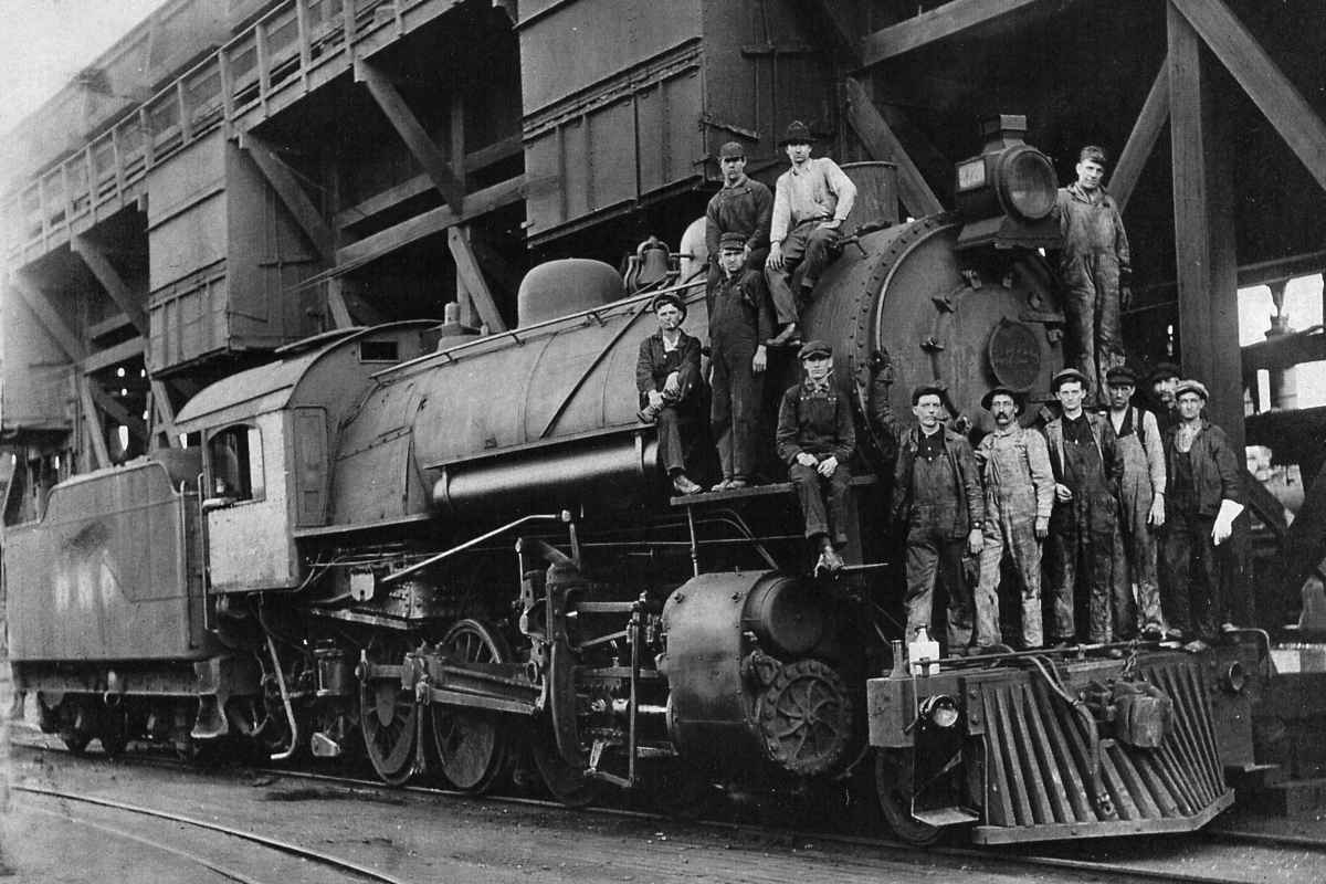
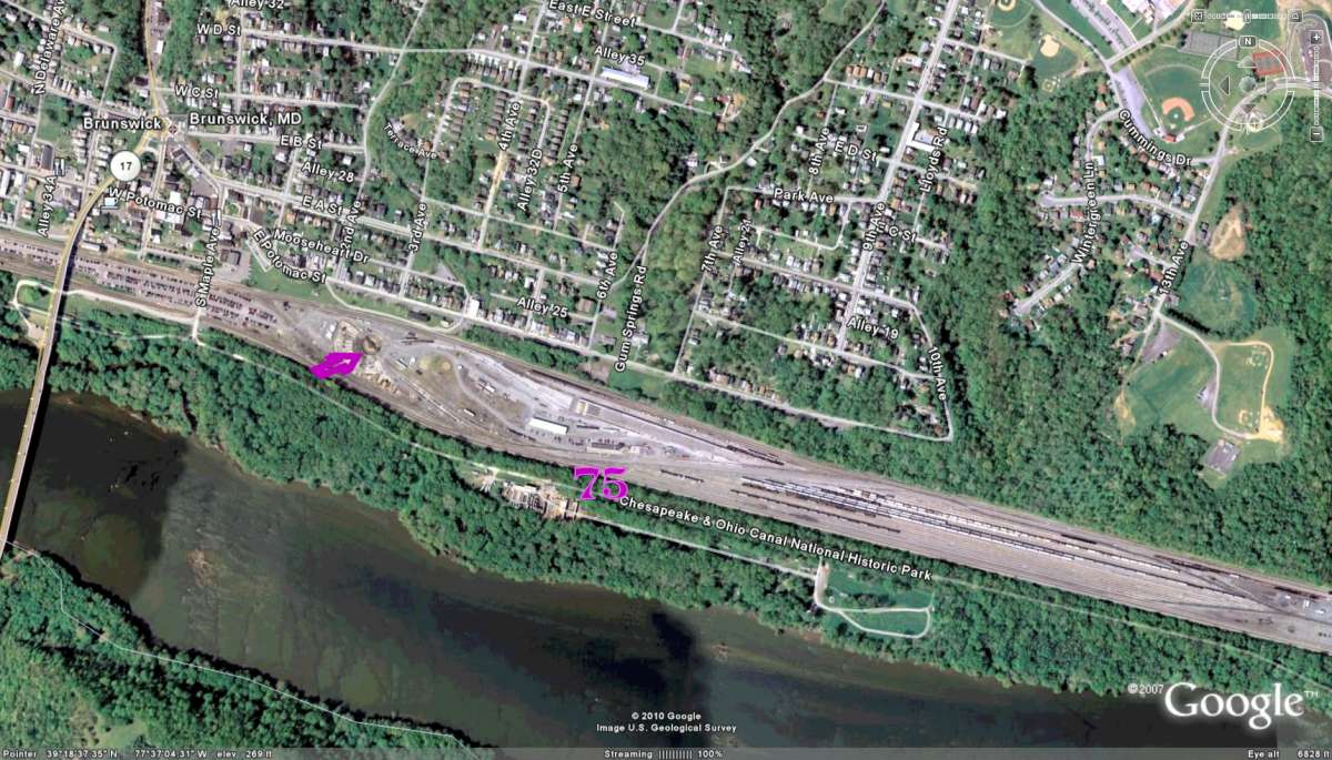
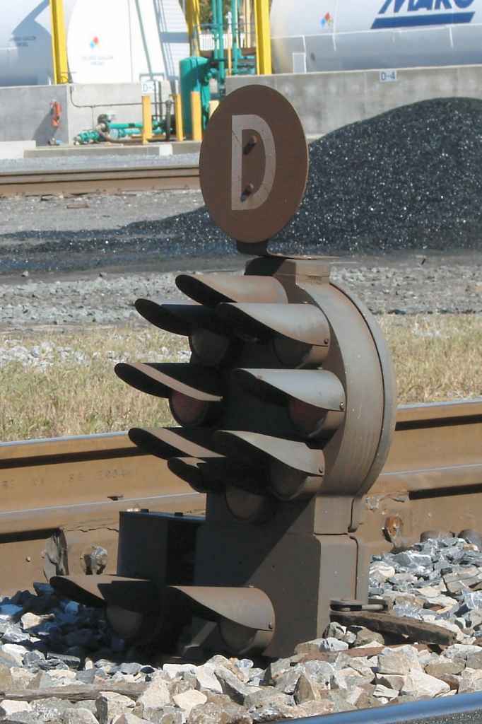
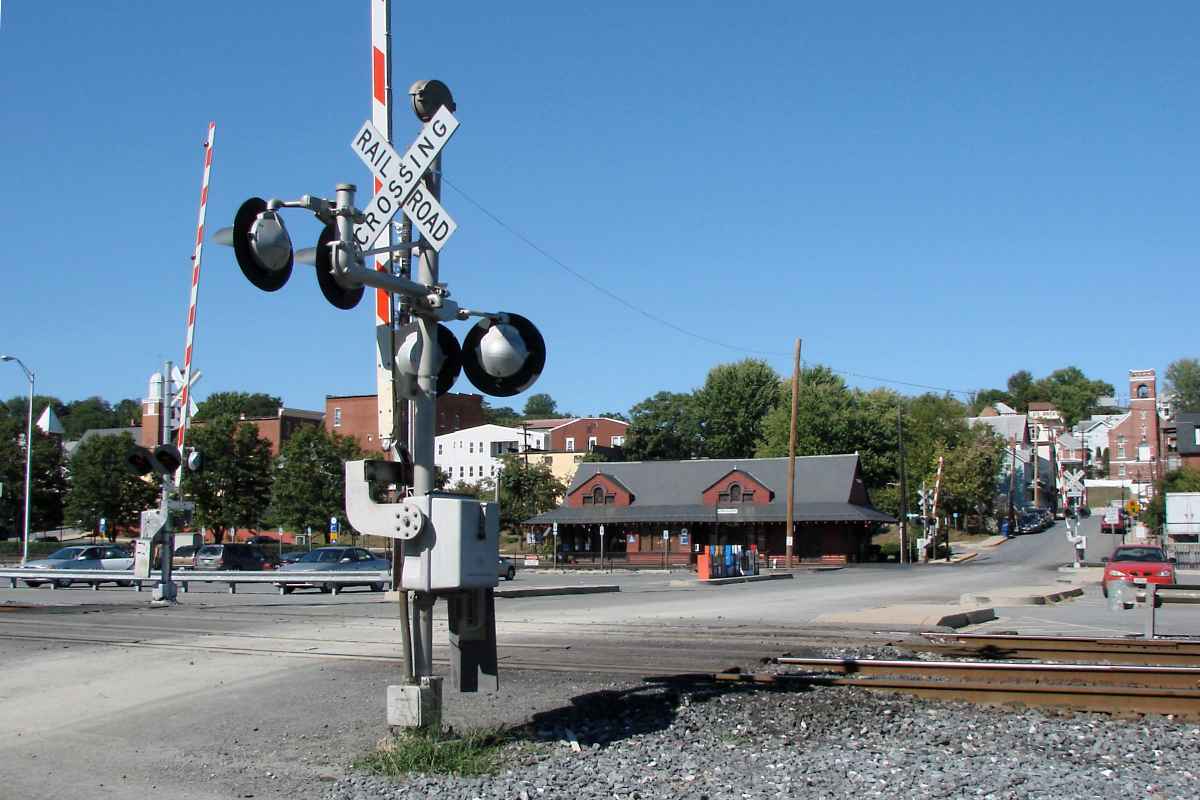
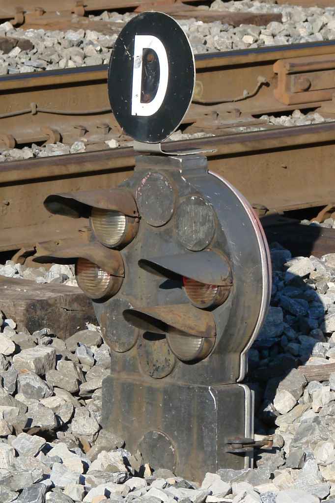
The dwarf CPLs at Brunswick come in many configurations. Here's an 8-lamper dressed up with two marker lamps for 10 total. You'd be hard pressed to find a dwarf CPL with more lamps. The most common CPL configuration had 6 lamps. lunar cpl

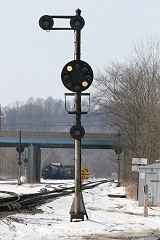
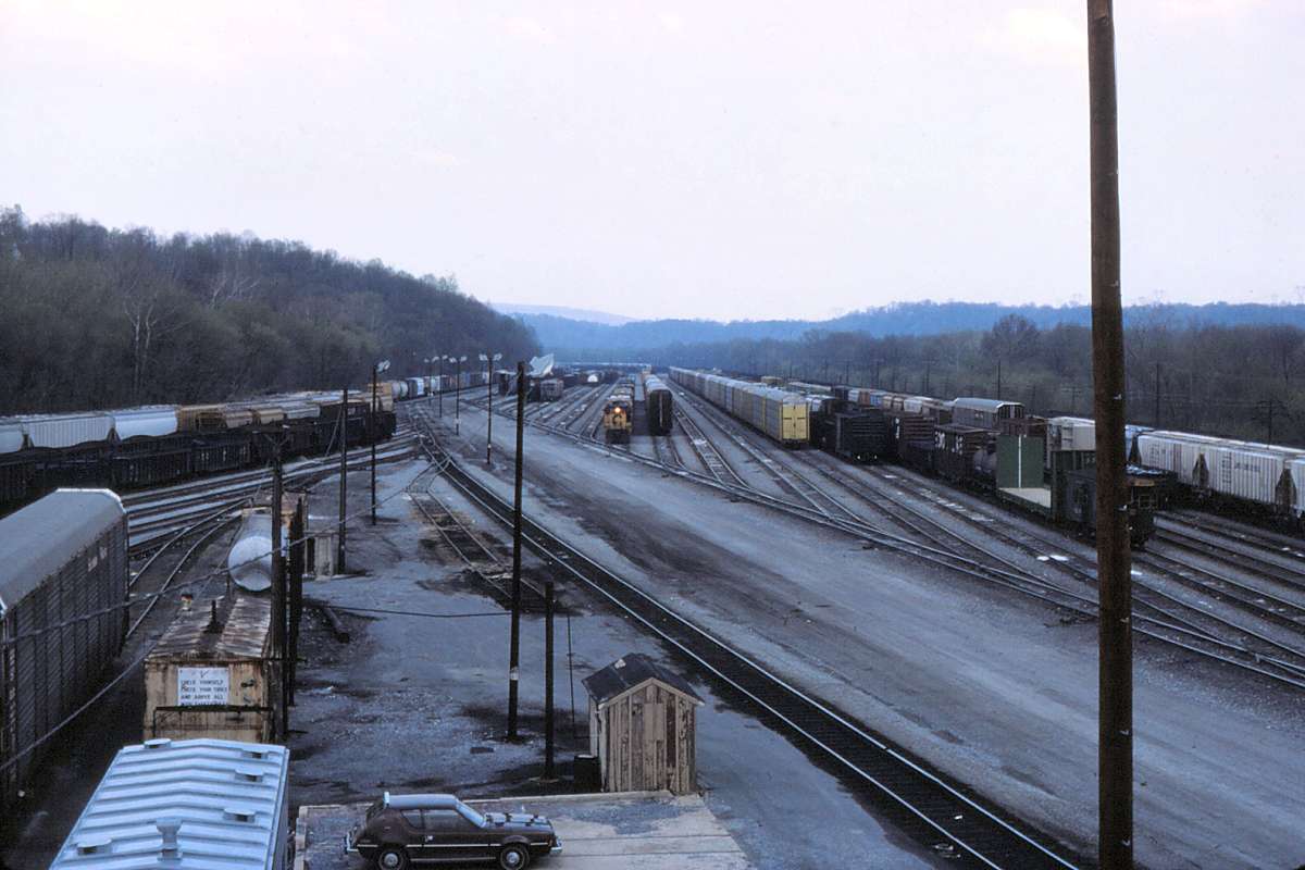
Eight-lamp CPLs were often found near rail yards because they have the upper-left and lower-right lights necessary to display a "Restricting" aspect. A Restricting aspect advises the train's operator to proceed without stopping, but do so at a speed slow enough to stop before any track obstruction he may observe on his own.

When lit, the Restricting speed indicators are a slightly blue-tinted white color like that of the Moon, hence they are sometimes called a "lunar" aspect. The example photo at right comes courtesy David Malohn. The lunar aspect is also used to alert the operator that he is entering unsignalled territory and thus must proceed cautiously and employ his own judgment.


WB Tower
Photo courtesy Dave Hiteshew

WB Tower
Mile: 75.3 Date: Sep 2007
Ease: B View: N
Area: B IC2: 189
Map: Fr 35 D 12 Topographic Maps

WB (West Brunswick), closed December 2011, was the last railroad tower to operate in Maryland. B&O once had many such towers, but technology has obviated them. About a mile east of here, another tower (East Brunswick) once stood.

A YMCA frequented by overnighting rail crews had stood beyond the tower on the other side of the tracks. It lasted from its 1907 construction until razed by a fire in 1980 or 1982 (sources vary).

Links: WB Tower and signals, 2022 move


WB Tower 2
Photo courtesy Dave Hiteshew

WB Tower 2
Mile: 75.4 Date: Sep 2007
Ease: A View: SE
Area: A IC2: 189
Map: Fr 35 D 12 Topographic Maps

Here's a more common view of the tower.

Links: 1985, 1986


South Maple Ave
Photo courtesy Dave Hiteshew

South Maple Ave
Mile: 75.4 Date: Sep 2007
Ease: A View: N
Area: A IC2: 399
Map: Fr 35 D 12 Topographic Maps

Large sections of what had been expansive railyards have been recycled into things like commuter parking lots.

Brunswick has the reputation for not being railfan-friendly, and it's easy to see why. All the equipment and the warren's nest of tracks make for a busy, dangerous area. If you visit, bring your zoom lens, heed the no trespassing signage and stay clear. Getting run over by a train can sort of take the fun out of the day.


Brunswick Station
Photo courtesy Dave Hiteshew

Brunswick Station
Mile: 75.5 Date: Sep 2007
Ease: A View: NE
Area: A IC2: 135, 189
Map: Fr 35 D 12 Topographic Maps

Brunswick was a major freight handling location, but that doesn't mean it lacked the essentials for passengers. This building originally acted as a real estate promotion office of B&O and in 1891 was located at 7th Avenue, but a few years later the railroad moved it here and repurposed it as a passenger station. A separate shack on the other (south) side of the tracks had previously served eastbound passengers.

When about a century old, the 1891 Francis Baldwin-designed building received a renovation to support MARC passenger operations, a role in which it continues today.

Links: 1983, 1985, 1993


Memorial
Photo courtesy Dave Hiteshew

Memorial
Mile: 75.5 Date: Sep 2007
Ease: A View: SE
Area: A IC2:
Map: Fr 35 D 11 Topographic Maps

The sign on this memorial structure reads "The bricks which make up the base of the bell memorial came from the B&O Roundhouse that once stood in Brunswick, Maryland. The bell is similar to the one that was aboard car #7752 on #P-286 on February 16, 1996."

I'd have preferred a better description, for example, something to tell us why these bricks and this bell were chosen. Reader Paul McNally filled in some details:

    "Thanks for your great site. I noticed the statement about the memorial in the Brunswick Yard section. P-286 was a MARC commuter train that collided with the Capital Limited in or near Silver Spring. A number of people survived the collision only to perish in the fire that followed. Since almost all commuters using the Met originate out of Brunswick, that would explain the bricks from the round house (the unit was more than likely serviced there). The bell would probably have come from a sister cab control unit (I recall the MARC train had been running with the engine at the rear heading into Washington)."

Link: MARC info in Wikipedia


4-Lamp Dwarf
Photo courtesy Dave Hiteshew

4-Lamp Dwarf
Mile: 75.6 Date: Sep 2007
Ease: A View: NE
Area: A IC2:
Map: Fr 35 C 12 Topographic Maps

As CSX phased out B&O's signature CPLs, Brunswick was one of the last strongholds. The "D" sign reminds push-pull trains to approach the next signal at a speed not exceeding 40 MPH, as provided by emergency order of the Federal Railroad Administration. These D markers are plastered upon so many signals as to, in my opinion, actually detract from their reminder purpose.

Link: 2002


CSX 4594
Photo courtesy Dave Hiteshew
NEW! mid-Jan 2021

CSX 4594
Mile: 75.7 Date: Oct 2007
Ease: B View: SE
Area: B IC2:
Map: Fr 35 C 12 Topographic Maps

This SD80MAC is looking sharp as it poses for the first known photo of CSX 4594 in fresh Dark Future paint after the unit was inherited from Conrail (CR 4410). Alas, the shine would wear off soon as this unit derailed in 2009, then was scavenged for parts until scrapped in 2014.

Link: 2012 parting out


Milepost 76
Photo courtesy Dave Hiteshew

Milepost 76
Mile: 76.0 Date: Oct 2007
Ease: B View: E
Area: B IC2:
Map: Fr 35 B 11 Topographic Maps

The 84 sign in the distance is not a milepost, but this nearer 76 is. Found at many milepost locations are whitewashed rails pounded into the ground as sturdier markers.

This is the now-disused west side of Brunswick Yard. It had handled eastbound traffic and included facilities such as pens to hold cattle given freedom from their cramped cars for a night. Another pair of tracks traverse on the north side of the yard, unseen about 500 feet away on the left.


Amtrak 18
Photo courtesy Dave Hiteshew

Amtrak 18
Mile: 76.0 Date: Sep 2007
Ease: A View: E
Area: A IC2:
Map: Fr 35 B 11 Topographic Maps

On that north side, Amtrak 18 zooms past the 84 sign. As seen in the next photo, 84 Lumber operates a store within the disused west yard, sandwiched between the eastbound and westbound tracks.


Sunset
Photo courtesy Dave Hiteshew

Sunset
Mile: 76.0 Date: Sep 2007
Ease: A View: E
Area: A IC2:
Map: Fr 35 B 11 Topographic Maps

Amtrak 18 leads a train west into an early autumn sunset.

Link: 2006?


<< Previous (east) | THIS PAGE: Brunswick Yard | Next (west) >>

Or, return to main page for other tours.

Copyright Notice