TrainWeb.org Facebook Page
WM Photo Tour


Western Maryland Railway
Modern day photo tour

Accompanying each photo below are:

Click a photo to see a larger view. Please send your comments and corrections to Steve


<< Previous (east) | THIS PAGE: Milford Mill to Sudbrook | Next (west) >>

Patterson Avenue

Patterson Avenue
Mile: 8.3 Date: Apr 2016
Ease: A View: SW
Area: C IC2:
Map: Ba 33 J 2 Topographic Maps

Visibility of the Patterson Avenue grade crossing is poor when approaching from the east. The two trafic signals (green at photo time) supplement the usual grade crossing signals, and had been found at many grade crossings within the city.


Quieter

Quieter
Mile: 8.3 Date: Apr 2016
Ease: A View: NW
Area: C IC2:
Map: Ba 33 J 2 Topographic Maps

We've survived the trip through the big, bad city and housing density declines from here west. The border of Baltimore City is a quarter mile in the distance, but before that the Metro (left) transitions from elevated to surface operation.


No Windows

No Windows
Mile: 8.9 Date: Apr 2016
Ease: A View: W
Area: C IC2:
Map: Ba 33 G 1 Topographic Maps

The sprawling Milford Station Apartments does not cater to railfans: note the lack of windows facing the tracks, but they do hang signs that can be seen through the windows of passing Metro trains. Reviews suggest a mice overpopulation, indeed peer into one of the old WM battery boxes along here and you'll likely find a colony.


Milepost 9

Milepost 9
Mile: 9.0 Date: Apr 2016
Ease: B View: NW
Area: C IC2:
Map: Ba 33 G 1 Topographic Maps

One such battery box is found beyond milepost 9, which suggests a WM signal was previously on duty here. A housing development on the left had been known as Mellinee.


Jointed

Jointed
Mile: 9.1 Date: Apr 2016
Ease: B View: N
Area: C IC2:
Map: Ba 33 G 1 Topographic Maps

Debris on the right implies WM had a station or other structure here long ago. The zoom view reveals jointed rails.


Boxes

Boxes
Mile: 9.3 Date: Apr 2016
Ease: A- View: E
Area: B- IC2:
Map: Ba 25 F 13 Topographic Maps

interior At the Old Milford Mill Road grade crossing, multiple battery boxes were back-up power for what looks to be a communications board, stripped of its innards years ago.

During the past a siding had run parallel and adjacent to the white building behind, home of Mrs. Pose Bakery since 1977.

Link: Pose Bakery


Howardville Then
Photo courtesy WM WestSub

Howardville Then
Mile: 9.3 Date: Nov 1918
Ease: A- View: NE
Area: B- IC2:
Map: Ba 25 F 13 Topographic Maps

At the grade crossing, WM erected a trackside freight and waiting shack.

The box on the pole right of the shack likely covered a warning bell.

Reader Stephen Miller reports:

    "The building behind the waiting shack was owned by a family named Burns. They ran a grocery store out of it and lived above the store. I remember going there with my father on Saturdays to shop. His wife ran the cash register and he was the butcher. They lived there until the Metro came through and bought their house. There was also a siding that ran directly next to the building. On occasion there would be a boxcar parked there that I could access from a door in the building. As far as I know they never got deliveries from the railroad."


Howardville 2016

Howardville 2016
Mile: 9.3 Date: Apr 2016
Ease: A- View: NE
Area: B- IC2:
Map: Ba 25 F 13 Topographic Maps

Having been absorbed into Pikesville, the Howardville name for this area has faded into history.

About a century later at the same location only the rails remain, including, if you look closely, one for the nearer track.


Former Grade Crossing

Former Grade Crossing
Mile: 9.3 Date: Apr 2016
Ease: A View: W
Area: B- IC2:
Map: Ba 25 F 13 Topographic Maps

The Milford Mill Road grade crossing was closed around 1985 when Metro barged through, but judging by the state of the end-of-road guardrail it would appear old habits die hard.

The rails in the foregound belong to the long siding mentioned earlier.


map
Photo courtesy Johns Hopkins University

Siding
Mile: 9 Date: 1972
Ease: View: N (up)
Area: IC2:
Map: Topographic Maps

In this aerial from 1972 the grade crossing is near the top. Note the siding parallel on the east (right) side of WM serving the two long dark-roofed buildings. Only the northern of that pair remains extant.

At this time, WM was still double-tracked through here. The trackside building on the left would soon be cleared to make room for Metro's Milford Mill Station.

Reader Stephen Miller details:

    "The aerial picture of the siding shows a group of buildings to the left. This was a large lumber yard that caught fire about the time of this picture. I remember that they had to close railroad access due to the fire hoses and fire equipment on the tracks. The fire was so intense that they had to hose down to buildings on the opposite side to keep them from catching fire."


Siding Remnant

Siding Remnant
Mile: 9.3 Date: Apr 2016
Ease: A View: S
Area: B- IC2:
Map: Ba 25 F 13 Topographic Maps

The siding was disconnected some time ago but evidence of it survives.


From Above

From Above
Mile: 9.4 Date: Apr 2016
Ease: A View: S
Area: B- IC2:
Map: Ba 25 F 13 Topographic Maps

The old Milford Mill Road grade crossing can be glimpsed on the left from the bridge that acts as its replacement. Metro's Millford Mill station is on the right.

From about 1910 into the 1950s several small airfields dotted the landscape in this vicinity, including City Line Airport and Curtiss-Wright Airport / Pimlico Airport. Their placement reveals this was mostly undeveloped land when the airplane made its initial foray into transportation.

Link: airfields


Slade Avenue

Slade Avenue
Mile: 9.5 Date: Apr 2016
Ease: A- View: N
Area: B IC2:
Map: Ba 25 F 13 Topographic Maps

Though Slade Avenue is a major thoroughfare in Pikesville, I have found no old maps depicting it crossing WM. It may always have ended at the tracks. The road was named in honor of former Baltimore County sheriff and postmaster William A. Slade.


Western Maryland Avenue

Western Maryland Avenue
Mile: 9.6 Date: Apr 2016
Ease: A- View: NE
Area: B IC2:
Map: Ba 25 F 13 Topographic Maps

safetran label Railroad Avenues are common, Western Maryland Avenues not as much.

A crew telephone call box made by Safetran Systems Corporation, Electro-Mechanical Division, bravely endures the elements.


Sprayer

Sprayer
Mile: 9.7 Date: Apr 2016
Ease: B+ View: E
Area: B IC2:
Map: Ba 25 F 12 Topographic Maps

Excessive trackside plant growth is asking for trouble come a hot, dry summer so these sprayer trucks were doing their thing during a fine spring day.

What's all that stuff on the left?


Collection

Collection
Mile: 9.7 Date: Apr 2016
Ease: A- View: E
Area: B IC2:
Map: Ba 25 F 12 Topographic Maps

It's a group of rusting tanks, compressors, pipes, and equipment boxes.

This had been an important switching location for eastbound WM trains during double-track days. Trains bound for Hillen Station would be switched onto one track while those headed for Port Covington would get the other.


Electro-Pneumatic

Electro-Pneumatic
Mile: 9.7 Date: Apr 2016
Ease: A- View: NE
Area: B IC2:
Map: Ba 25 F 12 Topographic Maps

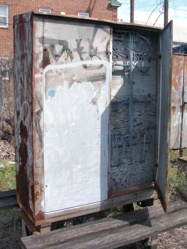
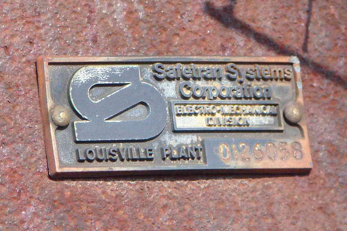
The Union Switch and Signal Company favored by WM was noted for inventing an electro-pneumatic signalling system in which compressed air powered the switch and the signals.

edited 
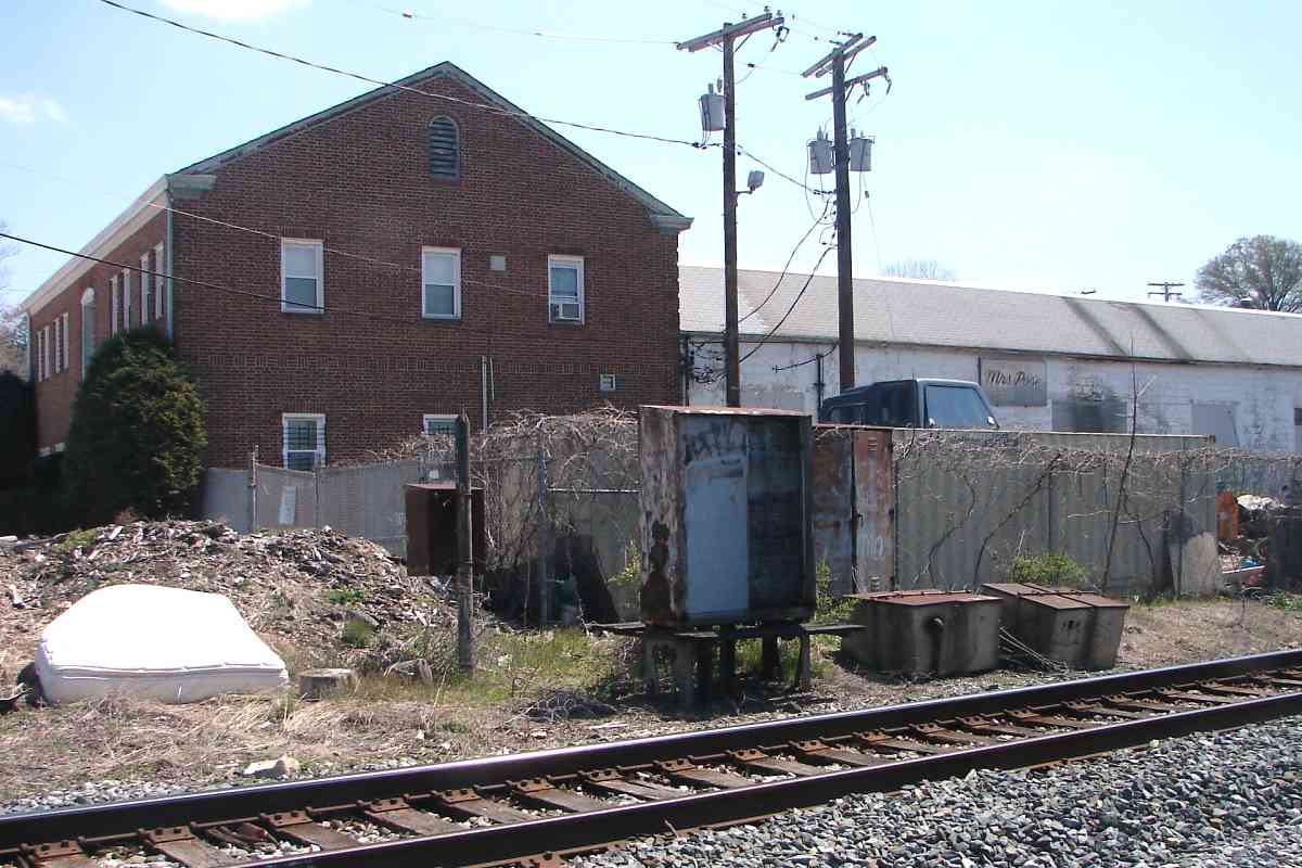
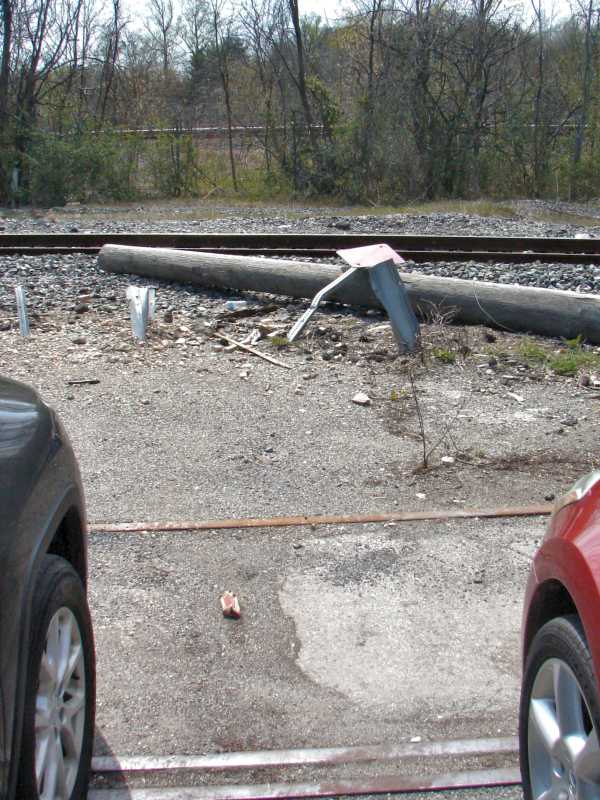
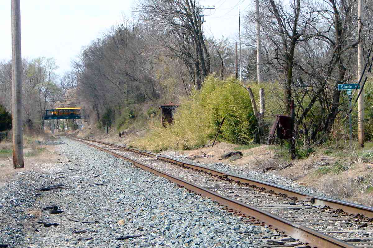
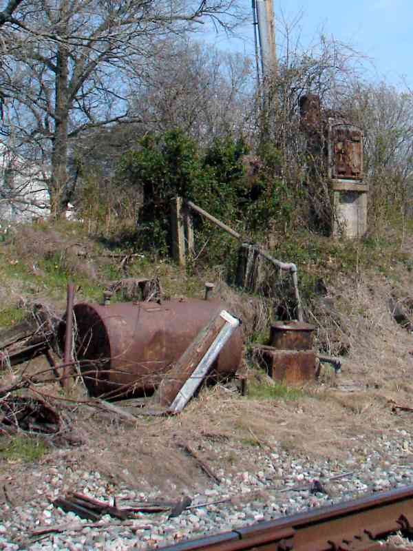
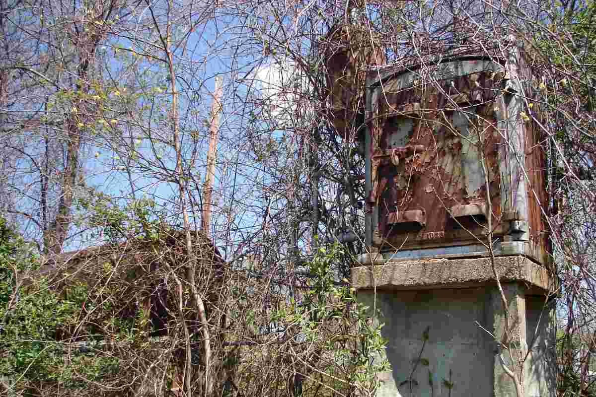
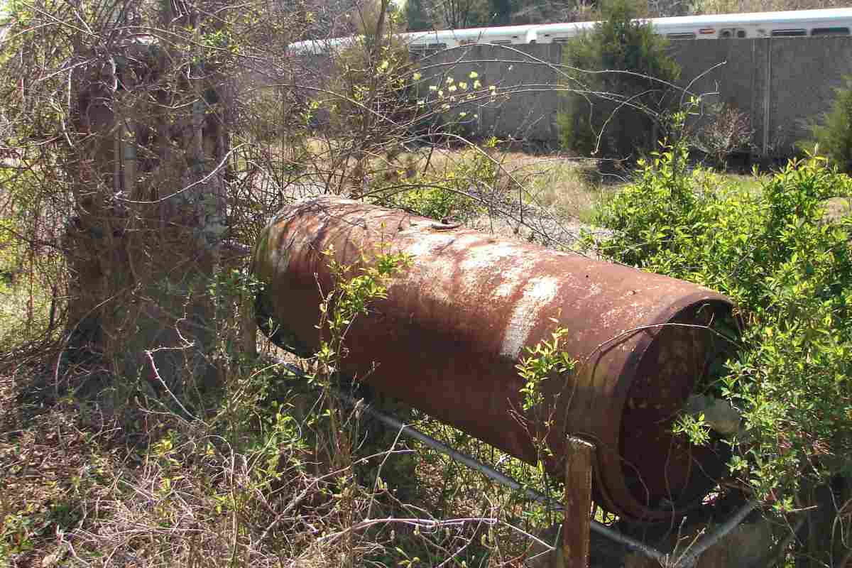
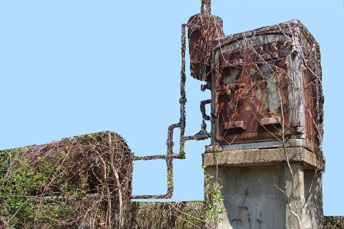
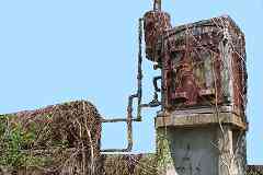
The number of tanks and the piping here indicates this had been one of the installation locations of such a pneumatic system for at least the switch (points). This is the only trackside survivor I've seen anywhere in the Baltimore region.

Vines shroud these artifacts during summer, and even during non-leaf season they hide details. A bit of digital editing helps sort things out.

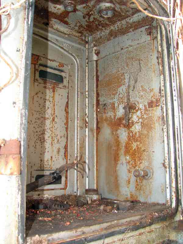
The US&S book linked below contains dozens of pictures and details but lacks a photo of an installation of these components. The closest in appearance, by coincidence, is the diagram on page 85.

Link: US&S Electro-Pneumatic Interlocking book (PDF)


Tank

Tank
Mile: 9.7 Date: Apr 2016
Ease: A View: S
Area: B IC2:
Map: Ba 25 F 12 Topographic Maps

interior Here are other views of the tank and main box, both now filled by little more than air. A Metro train is rolling by behind the wall.

Note the rusty, circular handle resting on the bottom of the box. Such handles are not used to control electricity, but they are found at valves for liquid and air. Though most pneumatic signals were converted to electrically operated ones during the first half of the 20th century, some WM pneumatic switches operated into the 21st century. This particular example likely endured until this area was single-tracked around the time Metro joined adjacent.

The tank resembles one trackside at Cold Spring Lane. Where there are multiple tanks the larger is a reservoir while the smaller is a drying tank (per Jersey Mike, blog).


Sudnrook
Image courtesy Johns Hopkins University
NEW! early-Sep 2022

Sudbrook
Mile: 9.8 Date: 1898
Ease: A View: N (up)
Area: B+ IC2:
Map: Ba 25 E 12 Topographic Maps

Next comes Sudbrook Park, a Frederick Law Olmstead project designed for well-to-do Baltimoreans to escape the heat of the city. It lies on the southwest side of WM (left).

Determining the exact location of WM's Sudbrook Station proved difficult, with maps sparse, photos conflicted, and local residents pointing to various spots. Finally during 2022 one (the only?) atlas to precisely depict the location emerged. Since this 1898 atlas correctly shows the location of many other railroad stations, it is likely correct about Sudbrook as well.

This atlas puts the station on the southwest side of the tracks, roughly across from Ralston development's Brightside Avenue. Brightside still exists, so it provides an easy reference point.


1927 Aerial
Photos courtesy Johns Hopkins University
Updated early-Sep 2022

1927 Aerial
Mile: 9.8 Date: 1927
Ease: View: N (up)
Area: B+ IC2:
Map: Ba 33 J 2 Topographic Maps

zoomed The station is visible trackside near the center of the zoom at left. This spot is southeast of the Sudbrook Road bridge.

Note the tracks curve ever so slightly to the west between the station and bridge. Northwest of the bridge they bend more sharply to the west. These curves will be referenced in photos further below.

Stephen Miller shares memories:

    "The 1927 shows two interesting features, at least to me. If you look closely to the left of the bridge is a tall tree. This was Sudbrook Parks Christmas tree. I remember it would be covered with full sized colored light bulbs installed by a person in a crane. There was a annual Christmas tree lighting that occurred in December. This tree was killed when BGE came through and replaced their gas lines. They cut through the trees roots and killed the tree. A replacement was planted further to the left of this picture and the ceremony still occurs every December."


Station Then
Photo courtesy WM WestSub
Updated early-Sep 2022

Station Then
Mile: 9.8 Date: Nov 1918?
Ease: B View: W
Area: B+ IC2:
Map: Ba 25 E 12 Topographic Maps

A new-at-photo-time passenger platform is trackside. Sudbrook Station would be used by passengers through 1930; the last train stopped here during the 1950s.

Note the 9.80 milepost information written on the photo. Other similar photos also have milepost info that matches the current milepost, hence I believe this photo to be accurate as well. Neverthelsss, other old photos are not a good match for the station here, as described below.

Stephen Miller says:

    "My father used this station for a short time before they stopped passage service. As a kid I remember playing there but even at that time is was overgrown. I do remember that the foundation was still there. We would access the tracks through a path in the overgrowth. They had removed the stairs and filled the area with what I think was slag or cinders. We would use this as a slide down to the tracks. The retaining wall that is shown in pictures of the Waiting Shed was still there at the time. When Metro came through there they shaved off the area removing any trace the station. That’s why your current picture shows a much reduced hillside."

Links: ~1900, station history


Metro Tunnel
Updated early-Sep 2022

Metro Tunnel
Mile: 9.7 Date: Apr 2016
Ease: A- View: NW
Area: B IC2:
Map: Ba 25 F 12 Topographic Maps

During the 1980s, excavations trimmed the hill where the station had been in order to make room for Baltimore's Metro subway line. The Metro and WM proceed under Sudbrook Lane in different manners.

If Sudbrook Station still existed, it would appear at the left near the sound barrier. Note the track is straight between the station site and the Sudbrook Lane bridge.


Sudbrook Park

Sudbrook Park
Mile: 9.8 Date: Apr 2016
Ease: B+ View: N
Area: B IC2:
Map: Ba 25 F 12 Topographic Maps

One of Sudbrook Park's main entrances is via this bridge carrying Sudbrook Lane. The original bridge endured from 1890 until replacement during 2005.

Link: Sudbrook Park history


View Then
Photo courtesy WM WestSub

View Then
Mile: 9.9 Date: ~1890
Ease: A View: S
Area: B+ IC2:
Map: Ba 25 E 12 Topographic Maps

Looking back from the original Sudbrook Lane bridge offered this view of WM's elegant Sudbrook Station, at a time when even children knew how to play safely near trains.

Notice that unlike today, the track is curved between the bridge and station. For years, this made me think the station had been north of the bridge, where a curve still exists. Now I believe the tracks were realigned subsequent to this photo.


View 2016
Updated early-Sep 2022

View 2016
Mile: 9.9 Date: Apr 2016
Ease: A View: N
Area: B+ IC2:
Map: Ba 25 E 12 Topographic Maps

This modern view from the bridge appears an excellent match for the old photo above -- with the tiny problem it looks the opposite direction, north rather than south! It matches the one above so well, for years I had been convinced the station was north of the bridge. The local homeowner with whom I chatted doubted his land was the station's location. He pointed to the southwest side of the railroad where the 1898 atlas places it.


Bridge Then
Photo courtesy WM WestSub

Bridge Then
Mile: 9.8 Date: ~1890
Ease: B View: NW
Area: B+ IC2:
Map: Ba 25 E 12 Topographic Maps

Let's examine another old photo. There's the original Sudbrook Lane bridge, and children are playing on the right, which suggests this is the reverse of the earlier view from the bridge, which means this was probably snapped at Sudbrook Station.


Bridge 2016
Updated early-Sep 2022

Bridge 2016
Mile: 10.0 Date: Apr 2016
Ease: B View: SE
Area: B+ IC2:
Map: Ba 25 E 12 Topographic Maps

And the modern view seems to match the old one quite well -- however, again this looks the opposite compass direction, southeast rather than northwest!

One possibility is WM shifted the line a bit as part of a relignment west of here, and that altered the location of the curve.


Somewhere

Somewhere
Mile: 10.0 Date: Apr 2016
Ease: B View: SE
Area: B+ IC2:
Map: Ba 25 E 12 Topographic Maps

One photo (below) suggests a small freight shed was located at milepost 10 (left).

CSX's excavations made to lower the track and create clearance for taller trains under the Sudbrook Lane bridge created drainage issues.


Station Alternate

Station Alternate
Mile: 10.0 Date: Apr 2016
Ease: B View: E
Area: B+ IC2:
Map: Ba 25 E 12 Topographic Maps

If the station were north of the bridge, which I now doubt, this would be the site. CSX's excavations turned up blocks of cut stone and other detritus suggesting a man-made structure. The photo below says a freight shed had been here, probably on the other side of the tracks.


Freight Shed
Photo courtesy Kilduffs
NEW! early-Sep 2022

Freight Shed
Mile: 10.0 Date: Nov 1918
Ease: B View: W?
Area: B+ IC2:
Map: Ba 25 E 12 Topographic Maps

There's the shed, at exacting milepost 10.01. It's odd for this shed to have been 0.2 miles west of the station, so it may be a leftover from when the line followed present day Greenwood Road.

Link: freight 1918


View

View
Mile: 9.9 Date: Apr 2016
Ease: A View: NW
Area: B+ IC2:
Map: Ba 25 E 12 Topographic Maps

Wherever the station and shed had been, when this tour resumes we'll continue westward. Barely visible near photo center is milepost 10.


<< Previous (east) | THIS PAGE: Milford Mill to Sudbrook | Next (west) >>

Or, return to main page for other tours

Copyright Notice