


Rails in Toronto Canada - The Railfan Guide to Toronto

This group has maintained an operating museum with Alco/MLW diesel power on the CN Uxbridge Subdivision, between the end of CN territory at Stouffville and the end of Rail in Uxbridge. Rumour has it the group will not operate in 2005, but stay tuned.
York Durham Historical Rail Home Page
The South Simcoe Railway is an operating museum with two working CP steam locomotives, 4-4-0 136 and 4-6-0 1057. The SSR runs from Tottenham to Beeton on a segment of the old CN Beeton Subdivision.
The HCRR is a superb operating traction museum located on Guelph Line, north of Highway 401, about 30 miles west of downtown Toronto.
The WSJR was a tourist railroad utilising an ex-CN branch line from Waterloo to St. Jacobs. It featured ex-CN FP9A's and coaches in the old green-black-and-gold colour scheme. The branch is now operated for freight by the Goderich-Exeter Railway. Passenger operation, which was a separate operation, ceased running in 1999. The equipment is currently stored at VIA's Maintenance Center in Toronto, and can be photographed from the Islington Avenue bridge.
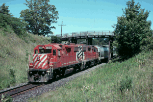
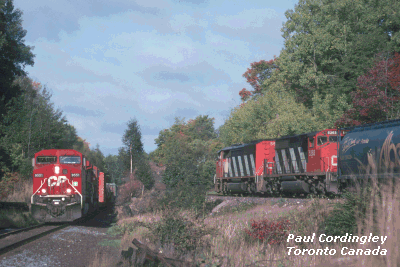
The CN Kingston and CP Belleville
Subdivisions run side by side for many miles east of Toronto on the
way to Montreal. There are some excellent photo opportunities in the
area east of Bowmanville. Scenery in this area is primarily farmland,
and the nearby Lake Ontario shoreline makes for a pretty backdrop.
Both lines are quite busy - you can count on seeing trains at any
time of the day.
To reach this area take Highway 401 east from Toronto, until you pass the Highway 115/35 junction east of Bowmanville. Just about any exit east of that point will take you south to the tracks. If one spot doesn't suit your tastes, the next one will.
 Two
especially good spots are on Nichols Road and Stacey Road, which run
north-south just east of Newtonville Road. Each of these locations
has a pair of pretty wooden bridges over the tracks. CN's Newtonville
crossovers lie in between these locations, right by the East Townline
Road grade crossing. You can get a map from Mapblast or Mapquest, the
lat/long coordinates are 43.918548 N and -78.44996 W. I like Stacey
Road the best but all three have really good views of both lines.
Lighting is good all the time.
Two
especially good spots are on Nichols Road and Stacey Road, which run
north-south just east of Newtonville Road. Each of these locations
has a pair of pretty wooden bridges over the tracks. CN's Newtonville
crossovers lie in between these locations, right by the East Townline
Road grade crossing. You can get a map from Mapblast or Mapquest, the
lat/long coordinates are 43.918548 N and -78.44996 W. I like Stacey
Road the best but all three have really good views of both lines.
Lighting is good all the time.
Another good spot is at Lovekin siding which is between Newtonville and Newcastle. There is a wooden bridge over CN and a level crossing with CP with a wide parking area. Just follow the shore road west from Newtonville and you'll find this spot.
CP frequently broadcasts a lineup for the Belleville Subdivision on 161.265 Mhz just after 07:00.
The CP and CN transcontinental lines come together in spots between Bala and Parry Sound, about 130 miles north of Toronto. This is a very scenic area with lots of lakes, rock cuts, and natural forest. To reach this area, take Highway 400 north from the city towards Parry Sound. This past year, the 4-lane highway was extended to Parry Sound. To reach Rosseau Road, access the old Highway 69 and watch for the local road running west just north of the junction with Highway 141. Parry Sound, further up Highway 69, is another good spot.
CP normally broadcasts a lineup for the Parry Sound Subdivision on 160.845 Mhz just after 07:00.
In spring and early summer, plenty of bug repellant is a must!
Dundas is a small city just northwest of Hamilton. It's the first station name on the CN Dundas Subdivision, west of the Bayview/Hamilton Jct/Hamilton West area. The CN main line climbs the Niagara Escarpment in this area.
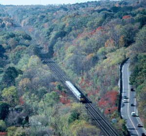 There
are high cliffs overlooking the CN right of way. The Bruce Trail - a
world-renowned hiking trail that runs from Niagara Falls to Tobermory
- runs along the top of the escarpment, with a number of conservation
areas along this trail. This is a wonderful place for hiking, with
many good vantage points overlooking the CN line.
There
are high cliffs overlooking the CN right of way. The Bruce Trail - a
world-renowned hiking trail that runs from Niagara Falls to Tobermory
- runs along the top of the escarpment, with a number of conservation
areas along this trail. This is a wonderful place for hiking, with
many good vantage points overlooking the CN line.
The prime lookout is in the Spencer Gorge Wilderness Area, where a rock outcropping overlooks the line. The scene looks west, all the way to the summit of the grade at Copetown. The Bruce Trail descends the escarpment here, crossing the CN right of way on a level clearing where the CN Dundas depot once stood.
You can reach the Spencer Gorge Trail from the Wilderness Area's parking lot on Harvest Road. Take Highway 8 to Harvest Road, or come south from Highway 5 on Ofield Rd South. The right of way of an abandoned narrow guage quarry railway crosses Harvest Road just east of the park. If arrive outside the park hours, of if you don't want to pay the parking fee, drive a little further east down Harvest Road, and you'll see a trail with room to park on the side of the road.
![]()
Copyright © 1996, Paul Cordingley
Revised - May 5, 2005
url:http://www.trainweb.org/railsintoronto/stone.html


