TrainWeb.org Facebook Page
Bowie Race Track Branch


PRR / Amtrak in Maryland
Modern day photo tour

Accompanying each photo below are:

Click a photo to see a larger view. Please send your comments and corrections to Steve.


Special Note: >>> Some places described on this page host quiet, high-speed trains. Stay well clear! <<<

<< Previous (north) | THIS PAGE: Bowie Race Track Branch | Next (main line, south) >>

Brief Historical Background:

Bowie Race Track Wye

Bowie Race Track Wye
Mile: (118.3) Date: May 2018
Ease: C View: NE
Area: A T6:
Map: PG 10 B 3 Topographic Maps

South of the Patuxent River bridge, in Prince George's County, we reach a location PRR called Arundel, or "Del" for short; locals called it Hicks Mill. As AMTK 2002 crosses that bridge, the photographer is standing where the northeast leg of PRR's wye to serve Bowie Race Track had been completed during November 1936.

This tour page proceeds generally south and southeast from here. Photos that look south and/or east (see View data) generally look toward the race track's location.


Wreck
Photo courtesy The Baltimore Sun

Wreck
Mile: 0.1 Date: Feb 1961
Ease: View: N
Area: T6:
Map: PG 10 B 3 Topographic Maps

Bowie RR Museum display It was at that leg of the wye that during a snowy February 1961 a Race Track Special derailed, killing six people and injuring more than half the approximately 400 people aboard. The two model F7 / PRR EF15A engines rolled onto their side.

A display (right) at the Bowie RR Museum quotes a witness, "People were thrown all around... glass was flying everywhere. Two or three seats back, a man was hanging out of the window, and I think he was dead."

Link: Bowie RR Museum info


Wye 1961
Photo courtesy The Baltimore Sun

Wye 1961
Mile: 0.2 Date: Feb 1961
Ease: View: N
Area: T6:
Map: PG 10 B 3 Topographic Maps

Newspaper accounts report the train had been travelling at 50 mph in the turnout rated at 15 mph. The PRR main line from the north descends at a 1% grade along the mile leading to the wye.

Link: 1961 wreck at this spot


Wye 2018
Photo courtesy Google

Wye 2018
Mile: 0.2 Date: Apr 2018
Ease: View: N
Area: T6:
Map: PG 10 B 3 Topographic Maps

Though disused for over 40 years, the wye remains visible in aerial photos.


Northeast Leg

Northeast Leg
Mile: 0.0 Date: May 2018
Ease: C View: SW
Area: A T6:
Map: PG 10 B 3 Topographic Maps

AMTK 2000 passes the location of the 1961 derailment. Unable to hold this turn to the left, the derailing equipment wound up in the trees at center.


Southwest Leg

Southwest Leg
Mile: 0.0 Date: May 2018
Ease: C View: NE
Area: A T6:
Map: PG 10 B 3 Topographic Maps

The southwest leg survives as this mound of earth that leads into the trees on the right. It is older than the northeast leg because it was built during the early 1930s as part of a siding to serve Charles L. Ruffin's Massaponax Corporation sand and gravel company. It was also the first to be disused when in 1961 PRR discontinued Race Track Specials from Washington.

PRR apparently scooped up adjacent soil, leaving behind low spots on either side of the mound where stagnant water now gathers.


Race Track Special
Photo credit John B. Yeabower

Race Track Special
Mile: Date: ~1935
Ease: A View: NE?
Area: C+ T6:
Map: DC 16 H 1 Topographic Maps

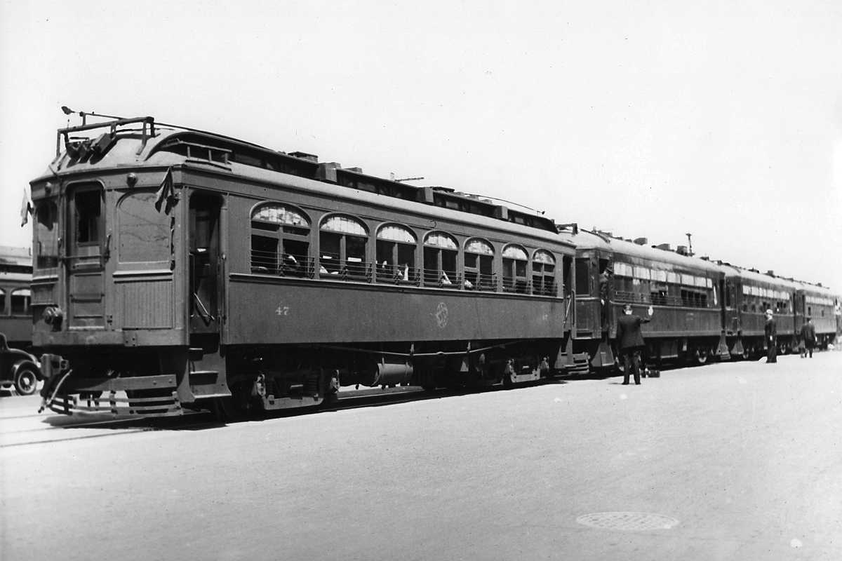
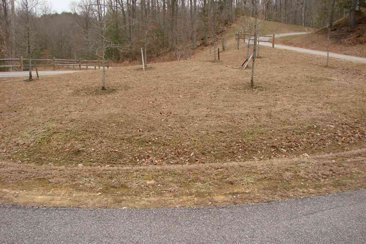
WB&A provided special service to the race track via 4-car trains like this. This photo may have been snapped near White House Station, then outside downtown Washington, and where full 4-car trains could be assembled without violating the city's 2-car limit.

1953 sched courtesy collection of Frank A. Wrabel 
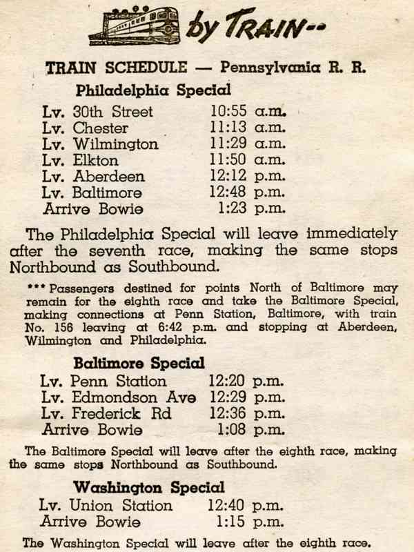
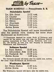
A 1953 PRR schedule (at right courtesy collection of Frank A. Wrabel) shows a race-day train arriving at Bowie 2.5 hours after departing Philadelphia, with stops at Chester (PA), Wilmington (DE), Elkton (MD), Aberdeen, and Baltimore. The trip from Baltimore took 35 minutes. From Penn Station the Baltimore Special stopped at Edmondson Avenue and Frederick Road, arriving after 48 minutes. The non-stop trip aboard the Washington Special from Union Station took 35 minutes.

By 1971, the Baltimore Special had been merged into the Philadelphia Special, which required 3 hours and 11 minutes from Philadelphia. The round trip fare, with Bowie admission, was $13.25. Racegoers from New York would depart at 8 AM then change for the special at Philadelphia around 10 AM.


Ballast

Ballast
Mile: 0.1 Date: May 2018
Ease: C View: SE
Area: A T6:
Map: PG 10 B 3 Topographic Maps

The northeast leg is preferred by the ATVers who churned up this ballast.


Del

Del
Mile: 0.2 Date: May 2018
Ease: C View: NW
Area: A T6:
Map: PG 10 B 3 Topographic Maps

The two legs of the wye met here where one found Del station, basically a shanty with a telephone. Since the line was not signalled service relied on telephonic communication. The southwest leg of the wye is much more overgrown, and can be identified here only by its shadow (left).

An 1878 Hopkins map shows this as the location of a steam-powered saw mill of John and Benjamin Hicks.


Track Map

Track Map
Mile: Date: 1949
Ease: View: NE (up)
Area: T6:
Map: PG 10 Topographic Maps

This track map shows the layout in schematic form. This tour is proceeding to the right.

Circa 1900 topographic maps illustrate most of the branch was built atop an old road that had crossed the B&P / PRR main line at grade on its way to Lemons Bridge.


Washout

Washout
Mile: 0.2 Date: Nov 2017
Ease: C View: NE
Area: A T6:
Map: PG 10 B 3 Topographic Maps

When PRR first arrived here, Massaponax was scouring the area for stone and sand. The excavation pits left behind are now water-filled, and complicate drainage to the Patuxent. Some past storm eroded the old right of way at this culvert. Crossing this spot on foot now during a damp month means slogging through mud, muck, and mosquitoes.


1938 Aerial
Photo courtesy Johns Hopkins University

1938 Aerial
Mile: Date: Apr 1938
Ease: View: N (up)
Area: T6:
Map: PG 10 Topographic Maps

This 1938 aerial shows the full branch. At this time the connection between PRR and the race track was only a couple years old.

The race track was caught off guard by the WB&A's closure during August 1935. The Boston Iron & Metal Company had purchased WB&A leftovers and quickly begun dismantling the steel rails and bridges for scrap. With the racing season scheduled to begin in November, track owners managed to convince the B&O to help. The solution including covincing the scrappers to delay their efforts, lowering the floor of the ex-WB&A Westport Tunnel, and adding clearance under low bridges so B&O equipment would fit. Then the newly-formed Baltimore & Annapolis leased B&O equipment and ran trains to Bowie... for just two weeks.

A longer-term solution began to take form during 1936 when PRR assumed service by switching trains at Odenton, Maryland from the main onto the almost parallel ex-WB&A track for a 6-mile trip to the race track. PRR deemed that length of parallel track too expensive to acquire and maintain, hence rushed into service the shorter connection this tour page follows.


Footings

Footings
Mile: 0.4 Date: Oct 2017
Ease: C+ View: N
Area: A T6:
Map: PG 10 C 3 Topographic Maps

Concrete pads and walls survive along the route. Some drawings show tipples about here where cars were loaded with sand and gravel.


Massaponax
Photo courtesy Google

Massaponax
Mile: 0.4? Date: ~1938
Ease: View: NE?
Area: A T6:
Map: PG 10 C 3 Topographic Maps

Those tipples are likely in the background left of this photo of Massaponax's operation from Gravel and Sand Deposits of Eastern Maryland by Nelson Horatio Darton. At this side of the tree line those dark rectangles may be railcars, and the pairs of light-color poles leftovers of WB&A's catenary. PRR's race track special trains rolled past all this on their way to the track.


Wide

Wide
Mile: 0.5 Date: Nov 2017
Ease: B- View: SE
Area: A T6:
Map: PG 10 C 3 Topographic Maps

Drawings also depict a small yard in this vicinity, which may account for the width of the opening in the trees. It's possible that briefly during the 1930s the yard was served concurrently by PRR from the north, and WB&A from the south.

Continuing south we reach a rails-to-trails effort known as the WB&A Spur Trail that has paved the route.


Ties

Ties
Mile: 0.6 Date: Nov 2017
Ease: B- View: S
Area: A T6:
Map: PG 10 C 4 Topographic Maps

Old track crossties can be found in many places along the trail including a few extra long ones. Lengthier ties are employed at track switches.


WB&A Trail Sign

WB&A Trail Sign
Mile: 0.8 Date: Nov 2017
Ease: B View: E
Area: A T6:
Map: PG 10 C 5 Topographic Maps

Trail signs are posted every quarter mile. The wording gives the impression this trail follows a WB&A Spur, and not one of PRR. I do not know whether that is a wording coincidence or confirmation WB&A's spur indeed had reached this far north.

AA Co trail Feb 2019 Eventually a bridge across the Patuxent River is slated to connect the main WB&A Trail in Prince George's County with the portion in Anne Arundel County, at which time the whole notion of a spur trail will fade into history. The planned bridge is near the site of a 19th century bridge that had spanned the river.

Shown at left is the Anne Arundel County trail that substitutes for WB&A's straight route that was severed by the Two Rivers community. The new, roundabout route will add over a mile to the WB&A Trail, and is much steeper than WB&A's alignment. There are two horseshoe curves like this along the way. At photo time this trail dead-ended down at the Patuxent River.


Bear Run

Bear Run
Mile: 1.2 Date: Nov 2017
Ease: B View: NE
Area: A T6:
Map: PG 10 C 5 Topographic Maps

WB+A herald The (PRR's?) culvert for Bear Run was replaced with this trail bridge.

This is another candidate location for the uncertain northern reach of the WB&A's spur to the gravel pits. South of here the line/trail becomes as straight as the arrow in WB&A's herald.


Quarter-Mile

Quarter-Mile
Mile: 1.3 Date: Nov 2017
Ease: B+ View: N
Area: A T6:
Map: PG 10 C 6 Topographic Maps

At the quarter-mile post, paint substitutes for ties and rails.


Walkway

Walkway
Mile: 1.5 Date: Nov 2017
Ease: B+ View: N
Area: A T6:
Map: PG 10 C 6 Topographic Maps

wetlands My guess is modifying the wetlands left behind by the sand and gravel miners would have required too much paperwork, so the trail built a short causeway of sorts across the muddiest stretch. Drainage is poor here.


Paved

Paved
Mile: 1.6 Date: Nov 2017
Ease: B+ View: N
Area: A T6:
Map: PG 10 C 6 Topographic Maps

All of the trail is paved, and where it rises higher above the ponds, it gets a guardrail/fence.


Spur Trail Start

Spur Trail Start
Mile: 1.7 Date: Nov 2017
Ease: A- View: S
Area: A T6:
Map: PG 10 C 7 Topographic Maps

We've reached the trail's start where the crossties are paint but the rails are real. The location, however, is not real railroad since the branch had instead continued straight through the clump of vegetation on the right, then onward to another wye.

About the spur, before the trail was built, reader Jim Younger had written:

    "The wye at 'Arundel' where the main met the branch is long gone. The actual right of way through the pines is now a vehicle road, which is more or less passable. All along the ROW there are ties and spikes, now mostly hidden by vegetation.

    "Where the branch met the WB&A (now the WB&A trail), you can see where two legs of the wye crossed the asphalt service road (to some county building). A little further on, amid more ties and spikes, there is the remainder of a trestle that crosses Horsepen Creek. This is at the base of the hill up to the actual grandstand area. Unfortunately, the PRR didn't signal the branch, opting to telephone between the shanty at Arundel and the one at the grandstand (both long gone).

    "When the grandstand was there, you could see the tracks in the pavement and you have a link to that already. Now that the grandstand is gone, the pavement and rails may be history too.

    "I always thought this branch was an interesting rail operation. It's just a shame to let it slip into obscurity."


WB&A Wye
Photos credit James P. Shuman

WB&A Wye
Mile: 1.7 Date: 1935
Ease: B- View: NE
Area: A T6:
Map: PG 10 C 7 Topographic Maps

In an attempt to stay solvent during its later years, WB&A provided freight service in the form of hauling gravel and sand. zoom This train is veering left from the WB&A main line onto the part of the branch we've just toured. Today, a trail parking lot accessed from Race Track Road is adjacent the right edge of this photo, but the old right-of-way is a tangle of thorny brush.

Into the distance (zoom view, right) the WB&A's main line dips towards its Patuxent River crossing, then rises on the Anne Arundel County side of that river. The dark line leading to the right is WB&A's track to Bowie Race Track. When PRR assumed race track service, it kept and reused all WB&A wye track in the foreground so it could both turn engines and hold trainsets that did not fit within the race track's yard.

Change for: WB&A tour at this site


Boyle

Boyle
Mile: 1.7 Date: Nov 2017
Ease: A View: NE
Area: A T6:
Map: PG 10 C 7 Topographic Maps

None of WB&A's wye survives in the grassy area at center, but overhead wires criss-cross above the site.

Bowie Race Track opened in 1914 at first under the name Prince George's Park then later Bowie Race Course. Soon WB&A extended a spur to it from this location known to the railroad as Boyle. In this photo the race track is to the right.

After the B&O/B&A partnership for two weeks of service to Bowie ended, PRR temporarily operated steam specials to the race track by connecting to the WB&A at Naval Academy Junction (Odenton). In time for the 1937-38 racing season, PRR built the shortcut seen earlier in this tour.

Link: Pennsy sends special train to rescue those snowbound at Bowie Race Track 1958


Naval Academy Junction
Photo credit James P. Shuman

Naval Academy Junction
Mile: Date: May 1935
Ease: A View: N
Area: A- T6:
Map: AA 12 J 3 Topographic Maps

This one-photo detour shows where PRR trains bound for Bowie Race Track during 1936 would have approached the camera while turning south onto ex-WB&A track near Rieve's Store in Odenton. As of this writing, the site of Rieve's Store is occupied by a Walgreens along MD 170 south of its intersection with 175.

Bowie Race Train sign courtesy collection of Frank A. Wrabel Potential passengers could identify PRR's special race trains by placards like the one at right (image courtesy collection of Frank A. Wrabel).

Link: 1936 abandonment


Trestle

Trestle
Mile: 1.8 Date: Nov 2017
Ease: B View: SE
Area: A T6:
Map: PG 10 C 7 Topographic Maps

This 1945 PRR-built trestle over Horsepen Branch replaced an earlier one of WB&A, and survives with rusty rails still on top.


Horsepen Branch

Horsepen Branch
Mile: 1.8 Date: Nov 2017
Ease: B- View: S
Area: A T6:
Map: PG 10 C 7 Topographic Maps

Adjacent the trestle, crumbling concrete suggests a structure of some sort, perhaps part of a system to collect water for the horses, of both the animal and iron varieties. USGS topo maps from the period place a "Water" label here, as they do at other locations where water was available for steam engines.


Rails

Rails
Mile: 1.8 Date: Nov 2017
Ease: B View: SE
Area: A T6:
Map: PG 10 C 7 Topographic Maps

Trains mag Aug 1944 Rails still extend across the top of the trestle. They may be the very same segments as seen in this 1946 Trains magazine photo that looks in much the same direction toward the racetrack. Back at the Boyle wye, PRR kept a pusher waiting in case trains could not climb this final hill up to the race track.

Links: Aug 1946 Trains magazine page 42, page 43, page 44, page 45


1950s Aerial
Photo courtesy City of Bowie

1950s Aerial
Mile: 1.7 Date: ~1955?
Ease: View: SE
Area: T6:
Map: PG 10 C 7 Topographic Maps

That hill leading up the to the train yard is at bottom left in this aerial view during an active racing day.

At the left edge of the photo, old maps place Bealmears Bridge across the (Big) Patuxent River. I hope to look for its remains some day.

Link: source photo


Track 1967
Photo credit P Morrisset

Track 1967
Mile: 1.9 Date: Mar 1967
Ease: B View: W
Area: A- T6:
Map: PG 10 D 7 Topographic Maps

Motive power during the 1960s was often E units, such as PRR 4273, an EMD E8A that at photo time had been recently renumbered from 5703 in preparation for the merger with New York Central that formed Penn Central.

Arriving 4273 has just passed the branch's "Track" control point that was located at the race track's northwest boundary. It is about to arrive in the yard behind the race track.


Track 2019

Track 2019
Mile: 1.9 Date: Mar 2019
Ease: B View: W
Area: A- T6:
Map: PG 10 D 7 Topographic Maps

If not for the rails still embedded in pavement one would not know this is the site of the previous photo. No remnants of the Track shack remain, not even a foundation, perhaps erased by a sewer line that was built here after the trains stopped running. Rusty rails litter the treed area ahead.


Flagged
Photo credit P Morrisset

Flagged
Mile: 1.9 Date: Mar 1967
Ease: B View: E
Area: A- T6:
Map: PG 10 D 7 Topographic Maps

The track's western entry road lacked crossing signals, hence a flagman oversees the process of the train rolling into the yard behind (north of) the race track. Anxious racegoers will soon disembark from this train and head to the track which is off photo right.

Link: 1962


Place Your Bets
Photo courtesy Frank A. Wrabel collection

Place Your Bets
Mile: 2.2 Date: 1946
Ease: B+ View: W
Area: A- T6:
Map: PG 10 D 7 Topographic Maps

Racing that had been suspended during World War II resumed in 1946 with help from some PRR K-4 Pacific 4-6-2 steamers.


Track Yard

Track Yard
Mile: 2.1 Date: Nov 2017
Ease: B+ View: W
Area: A- T6:
Map: PG 10 D 7 Topographic Maps

The tracks behind the track survive, but perhaps for not much longer since both redevelopment and revival are being studied for the site. Bowie Race Track has been closed since 1985, and its horse training center ceased operation during 2015.

During 2018 The Stronach Group, the dominant player in Maryland horseracing, announced plans to shift activity away from Pimilco in Baltimore, to both Laurel and Bowie.

The train yard was/is to the north of the race oval. There were/are 8 train tracks, each 600 to 1010 feet in length, where past racegoers disembarked then later, richer or poorer, climbed back aboard. During peak popularity, 10 trains would arrive per race day. The trains departed after certain races of that day, such as the seventh or ninth, had been completed.

Links: similar view 1992, proposal 2019


Grandstand
Photo courtesy Marty Hager

Grandstand
Mile: 2.2 Date: Nov 2003
Ease: B+ View: N
Area: A- T6:
Map: PG 10 D 7 Topographic Maps

This grandstand was demolished and carted away during 2004.

Link: 2004 report of demolition


Race Track

Race Track
Mile: 2.2 Date: Nov 2017
Ease: B+ View: SW
Area: A- T6:
Map: PG 10 D 7 Topographic Maps

This was the view to the southwest from the grandstand. The location was intentional: by keeping racegoers in the warm sun Bowie could host races during the winter, the only track in/near the northeast US to do so.

Under the Penn Central banner, the final scheduled train departed from Bowie on April 17, 1971. After Amtrak began control of much passenger rail service on May 1, 1971 it did not continue trains to Bowie.


THE MAKING OF THIS PAGE

In addition to the photos graciously contributed, I gathered some of my own, including these:


Bridge Out

Bridge Out
Mile: Date: May 2018
Ease: B View: E
Area: A T6:
Map: PG 10 B 4 Topographic Maps

Reaching the wye at the main line looked simple: there are paved paths behind Bowie State University. However those paths turn to dirt and split, with no signage.

After taking several wrong turns that led to swamps, we found a bridge. Its decking has seen better days but the metal structure looked like it could support us, so onward we went.


Swampy

Swampy
Mile: Date: May 2018
Ease: B View: SW
Area: A T6:
Map: PG 10 B 3 Topographic Maps

That also led to puddles and streams. Even the service "road" was underwater during 2018's damp, but very green spring. We wanted to reach somewhere on the right.


Beaver Dam

Beaver Dam
Mile: Date: May 2018
Ease: B View: W
Area: A T6:
Map: PG 10 B 3 Topographic Maps

The beavers are making this area so swampy the forest service has resorted to mining their ponds.

No, that object on the left appears to be the case of a discarded electrical transformer.

Will a beaver dam support the weight of a person who wishes to cross? We learned the answer is yes - provided one does not slip off it.

Link: mine that washed up on Gilligan's Island


Ballast Mountain

Ballast Mountain
Mile: Date: May 2018
Ease: B- View: N
Area: A T6:
Map: PG 10 B 3 Topographic Maps

The railroad dealt with the swamp by mounding the earth, then adding layer upon layer of stone ballast, creating what looks to be a large hill made entirely of ballast. The hill is over 20 feet high and the stone is loose.

Ultimately, reaching the wye required an entirely different route.


<< Previous (north) | THIS PAGE: Bowie Race Track Branch | Next (main line, south) >>

Or, return to main page

Copyright Notice