TrainWeb.org Facebook Page
PRR / Amtrak Photo Tour


PRR / Amtrak in Maryland
Modern day photo tour

Accompanying each photo below are:

Click a photo to see a larger view. Please send your comments and corrections to Steve.


Special Note: >>> The places described on this page host quiet, high-speed trains. Stay well clear! <<<

<< Previous (north) | THIS PAGE: Piney Orchard to Arundel | Next (branch) >>

Amtrak C&S

Amtrak C&S
Mile: 113.8 Date: Oct 2018
Ease: B View: SE
Area: B T6:
Map: AA 12 H 4 Topographic Maps

This is the newest version of the trackside manhole covers. C&S stands for Communication & Signals.


Piney Orchard

Piney Orchard
Mile: 113.8 Date: Oct 2018
Ease: B View: S
Area: B T6:
Map: AA 12 H 4 Topographic Maps

The line reaches its highest elevation in the Piney Orchard area of Anne Arundel County. Here the ascent from the Patapsco River becomes a decline to the Patuxent River. A grade crossing with Lokus Road near the center of this photo was closed around 1930.

Link: Derailment 12 Jul 2019


Piney Orchard Yards

Piney Orchard Yards
Mile: 114.5 Date: Apr 2003
Ease: B View: NE
Area: B+ T6:
Map: AA 12 G 5 Topographic Maps

Piney Orchard's water tower does its best jellyfish imitation near an Amtrak yard.

This small yard hosts Amtrak maintenance of way equipment. During my 2003 visit, the place was deserted, except for several run-down looking MOW units. Later visits found more activity. The yard dates to 1981.

Apr 2003 MARC 68, Oct 2017 AMTK A16501, Apr 2003 LMIX 506, Oct 2017 AMTK A16104, Oct 2017 Oct 2017 SBC-8, Oct 2017 Apr 2003

Links: 1988, 1988, 1988, 1988, 1988, 2013 inside MARC 68


Signals

Signals
Mile: 115.0 Date: Oct 2018
Ease: B- View: NE
Area: B T6:
Map: AA 12 F 5 Topographic Maps

Trains bypassing the yard come under the jurisdiction of these signals.

Deep zoom reveals heat distortion even on a mild autumn day. This tour has more deep zoom photos than other tours because reasonable access to the Penn Line is more limited. Enjoy only from a safe distance.


Amtrak 617

Amtrak 617
Mile: 115.0 Date: Oct 2018
Ease: B- View: NE
Area: B T6:
Map: AA 12 F 5 Topographic Maps

Oct 2018 These bi-level cars are Viewliner Sleeper Cars. The car at the end carries baggage.

Before the 1970s, many of the PRR's baggage cars doubled as railway post office (RPO) cars for the United States Post Office Department. B&O had procured the first contract to regularly carry mail around 1835. The last RPO run between New York and Washington, DC happened on June 30, 1977.

Links: Viewliner info, baggage car info


MARC 26

MARC 26
Mile: 115.5 Date: Oct 2018
Ease: B View: SW
Area: C? T6:
Map: AA 12 E 6 Topographic Maps

Northbound MARC 26 leads six bi-level cars that are not sleeper cars, though some exhausted commuters have been known to doze off in them.


Range Road

Range Road
Mile: 115.6 Date: Aug 2000
Ease: A- View: NW
Area: F? T6:
Map: AA 12 D 7 Topographic Maps

Original B&P stonework is found along the western side of the bridge over Range Road and Rogue Harbor Branch. The remainder is relatively looking SE, Nov 2018 newer concrete, probably dating from when the bridge was widened for 3 tracks around 1930. Four tracks might fit as well.

As might be obvious from the stream's location, these two photos look opposite directions. Since Range Road no longer connects through, driving from the location of the photo above to the one at left involves a roughly 14-mile, 40-minute trek.

Note that judging by post-2000 graffiti and gunfire, this seems to have become a favored hangout of well-armed teenagers.


Map 1878
Image courtesy Johns Hopkins University
NEW! early-May 2025

Map 1878
Mile: ~113 to ~118 Date: 1878
Ease: View: N (up)
Area: T6:
Map: AA 12 E 8 (center) Topographic Maps

This tour is proceeding southwest (toward bottom left). Drawn when B&P was less than a decade old, this map shows at least five grade crossings between Odenton (upper right) and the Patuxent River (lower left). All of them were eliminated during the century that followed.

North of the river near J. T. Thurle's land from the 1920s to the 1950s, the Salvation Army operated a summer camp known as Happyland, and later Camp Patuxent, for disadvantaged families of Washington, DC. Attendees arrived via train, and later by bus.

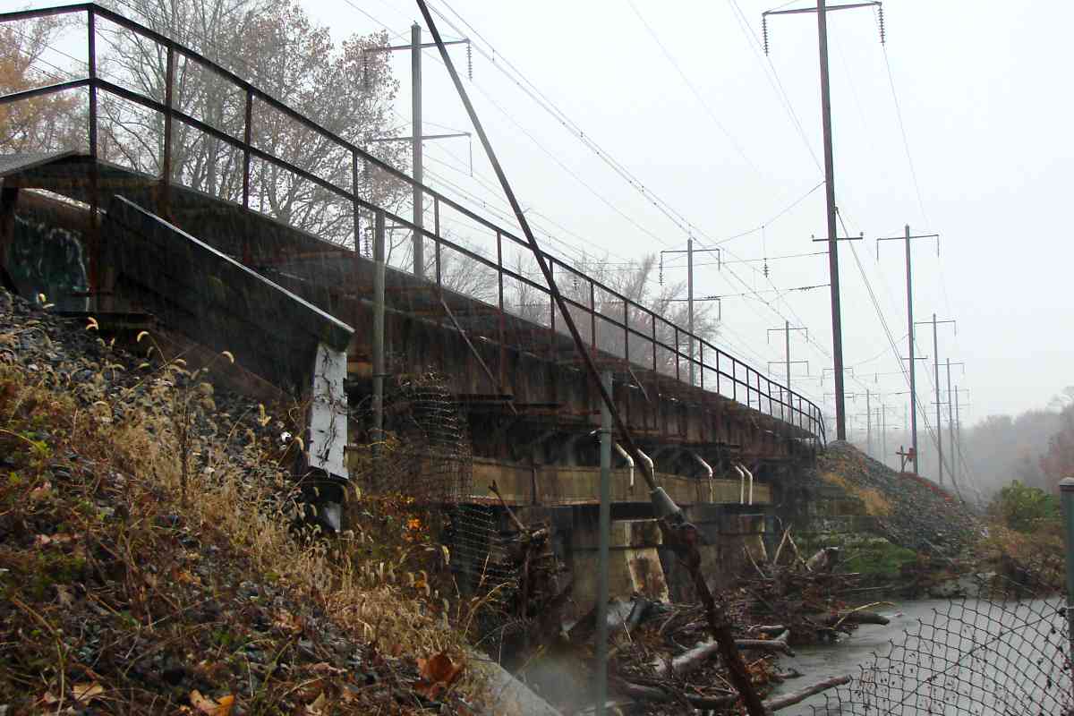
The tour is about to cross the Little Patuxent River, the \ diagonal wandering through the left half of this map. Beyond the river, B&P's Patuxent Station appears to have stood on the west side of the tracks. Its closing date is unknown, but it continued to appear on PRR station lists through at least 1945.

Link: Happyland


Little Patuxent

Little Patuxent
Mile: 116.0 Date: Nov 2018
Ease: C View: SW
Area: C? T6: 347
Map: AA 12 D 8 Topographic Maps

Rain at 39 degrees arrived sooner than forecast, making for one of looking NW, Oct 2017 the more miserable - but memorable - rail history research outings. I'm told, "Nothin' lasts forever, even cold November rain."

The view at left from downstream came during a much more pleasant autumn day, though it seemed no amount of waiting would produce a train. The supports appear to have room on this, their east side, for the planned 4th track.


Fifth Avenue

Fifth Avenue
Mile: 116.4 Date: Oct 2017
Ease: A View: SE
Area: A- T6:
Map: AA 12 C 8 Topographic Maps

Sleepy Woodwardville's capriciously-named Fifth Avenue is the Penn Line's only driveable single-lane underpass. Fifth Avenue serves a tiny trackside community, the only one between Odenton and Bowie on the west side of the line. A cannery had operated near here during the 1800s.

Stonework dates this grade separation to circa 1870 original B&P construction. The bridge for the trains was widened for 3 tracks probably around 1930, with room made for 4 plus a maintenance road.


MARC 7857

MARC 7857
Mile: 116.5 Date: Oct 2017
Ease: B View: NE
Area: A- T6:
Map: AA 12 C 9 Topographic Maps

South of Fifth Avenue, MARC 7857 splits the uprights.


Split

Split
Mile: 116.5 Date: Oct 2017
Ease: B View: S
Area: A- T6:
Map: AA 12 C 9 Topographic Maps

A little farther south, we come upon one of the Penn Line's more insulated crossbar curious (re)configurations. What had been triple track on the left was during the 1980s split into two separate rights of way.

The bracing between old and new catenary columns appears to be a customized crossbar, insulated to prevent current from flowing between the rights of way, even if a live wire falls onto it. The other end of the split does not have similar bracing. The black rectangles at the track detect problems with the cars rolling above.


MARC 18

MARC 18
Mile: 116.9 Date: Nov 2018
Ease: C View: S
Area: A T6:
Map: AA 12 C 10 Topographic Maps

Single track now occupies where triple track was found during the 20th century. This is the only place along the Northeast Corridor that one can find a train on a single-track alignment.


Amtrak 656

Amtrak 656
Mile: 117.0 Date: Nov 2018
Ease: C+ View: S
Area: A T6:
Map: AA 12 C 10 Topographic Maps

The new alignment received double track. The new alignment is, at most, 150 feet away from the original. Though the new alignment lessens a curve, if that were the goal, an even straighter path was possible.


C&S Shed

C&S Shed
Mile: 117.4 Date: Oct 2017
Ease: B View: NW
Area: A T6: 248
Map: AA 12 B 11 Topographic Maps

keystone Very possibly the last survivor of its kind in Maryland, this PRR-keystone-sporting Communications and Signals shed (right) stands in relative obscurity along the least-developed Penn Line mile between Baltimore and Washington. This PRR concrete design was popular during the 1908-1918 period after which the railroad shifted to steel sheds. The PRR used a three-window version of this shed as a Block Station. This one was made by Massey Concrete Products Corporation.

B&P had a stop in this vicinity named Anderson.

As for CUT SEC, SEC refers to a section of track for cab signalling purposes, hence the insulated track joints in the foreground. CUT? Perhaps circuit? This is where the Severn (PRR section 22) and Bowie (PRR section 23) substation circuits meet.

Link: PRR power overview from 1935 (PDF file)


MARC 32

MARC 32
Mile: 117.5 Date: Oct 2017
Ease: B View: SW
Area: A T6:
Map: AA 12 B 11 Topographic Maps

Baltimore-bound MARC 32 reaches the Conway Road grade crossing that closed during the 1940s when Fort Meade expanded.


Amtrak 2031

Amtrak 2031
Mile: 117.5 Date: Mar 2019
Ease: B View: NE
Area: A T6:
Map: AA 12 B 12 Topographic Maps

Crews were working on the original alignment as AMTK 2031 took the newer route. A disused signal bridge rusts in the foreground.


Amtrak 651

Amtrak 651
Mile: 117.9 Date: Mar 2019
Ease: C- View: SW
Area: A T6:
Map: AA 12 B 12 Topographic Maps

On a gray day, milepost 118 peeks up on the right to see that northbound AMTK 651 has just crossed into Anne Arundel County.


Bridge 1885
Photo credit Wilson Brothers Company
NEW! early-May 2025

Bridge 1885
Mile: 118.0 Date: 1885
Ease: C- View: SW
Area: stay off tracks T6:
Map: AA 12 A 12 Topographic Maps

The Patuxent River separates Anne Arundel and Prince George's counties thereby necessitating a bridge. A B&P two-track version, probably made of wood and/or iron, survived floods of August 13, 1873 see tracks think train because the embankments at both ends were washed downstream, thus widening the passage for the river. I believe the steel version seen here replaced it circa 1885.

Please do not take photos from the tracks. Attempting that is tempting fate because modern Amtrak electric trains are very quiet and very fast. There is insufficient time to get out of the way of a 100 mph train that surprises you. I want you to be able to come back to this web site often.

Links: source photo, a B&P iron bridge, See Tracks? Think Train


Aerial
Photo courtesy Library of Congress

Aerial
Mile: 118.2 Date: 1970s
Ease: View: E
Area: T6:
Map: PG 10 B 3 Topographic Maps

I have not found when the 1885 bridge was replaced by this one. I would speculate that happened circa 1930 when the line was electrified.

Links: 1873 flood, LoC Source photo ~1970


Patuxent River

Patuxent River
Mile: 118.1 Date: Aug 2000
Ease: C View: NE
Area: A T6:
Map: PG 10 B 2 Topographic Maps

The PRR bridge over the Patuxent River is much like its one over the Patapsco: low and long. At one time, it supported 4 tracks, but only 3 have been raised and upgraded for Northeast Corridor use, while the 4th, seen straight ahead in this photo, grows moss as a maintenance truck accessway.

B&O spanned the Patuxent River via a higher, shorter bridge at Laurel, about 10 miles upstream (left).


Underneath

Underneath
Mile: 118.1 Date: May 2018
Ease: C View: NE
Area: A- T6:
Map: PG 10 B 2 Topographic Maps

The line's piecemeal upgrading over time is revealed by the varying styles of track supports.

With Maryland being prime B&O turf, little has been penned about the history of this B&P/PRR line. As of this writing, this photo tour is the most comprehensive online historical documentation of the line.


Amtrak 616

Amtrak 616
Mile: 118.3 Date: May 2018
Ease: B- View: NE
Area: A T6:
Map: PG 10 B 3 Topographic Maps

Deep zoom looking back north finds AMTK 616 passing milepost 118 as it approaches PG County.


Bowie Racetrack Wye

Bowie Racetrack Wye
Mile: 118.3 Date: May 2018
Ease: C View: SW
Area: A T6:
Map: PG 10 B 3 Topographic Maps

About the Bowie Race Track Branch, reader Jim Younger wrote:

    "The wye at 'Arundel' where the main met the branch is long gone. The actual right of way through the pines is now a vehicle road, which is more or less passable. All along the ROW there are ties and spikes, now mostly hidden by vegetation.

    "I always thought this branch was an interesting rail operation. It's just a shame to let it slip into obscurity."

The next page tours the branch...


<< Previous (north) | THIS PAGE: Piney Orchard to Arundel | Next (branch) >>

Or, return to main page

Copyright Notice