TrainWeb.org Facebook Page
Trolley Photo Tour


Trolley Line #9
Modern day photo tour

Accompanying each photo below are:

Click a photo to see a larger view. Please send your comments and corrections to Steve.


<< Previous (index) | THIS PAGE: Ellicott City to Oella | Next (east) >>

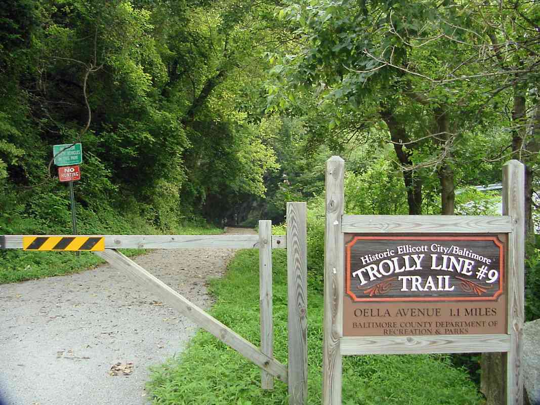
Brief Historical Background: Trolley Line #9

Terminal
Photo courtesy Kilduffs
NEW! May 2026

Terminal
Mile: -0.3 Date: 1950s
Ease: A View: NE
Area: A BSTPY: 55
Map: Ho 12 F 9 Topographic Maps

Trolley Line #9's westernmost reach was near Howard County's Court Avenue adjacent to 8390 Main Street. As such, it was Baltimore's only line that ventured into another county.

Links: 1955, 1955


Terminal 2026
NEW! May 2026

Terminal 2026
Mile: -0.3 Date: Apr 2026
Ease: A View: NE
Area: A BSTPY:
Map: Ho 12 F 9 Topographic Maps

The former fire department building remains standing, but the trolley's waiting spot has been remade into parking.


Aerial 1952
Photo courtesy Johns Hopkins University
NEW! May 2026

Aerial 1952
Mile: -0.3 to 0.1 Date: Aug 1952
Ease: View: N (up)
Area: BSTPY:
Map: Ho 12 G 9 Topographic Maps

Court Avenue Station is the building nearest the upper left corner. From there, the trolley followed Main Street (the bright horizontal line) through Ellicott City east to its Patapsco River crossing. The arrow points to what might be a trolley car.


Main Street
NEW! May 2026

Main Street
Mile: 0.0 Date: 1955
Ease: A- View: W
Area: A BSTPY: 55
Map: Ho 12 G 9 Topographic Maps

The trip along narrow Main Street could be delayed by automobiles parked far from the curb.

Link: looking east on Main St. 1955


Under B&O
Photo credit unknown
Updated May 2026

Under B&O
Mile: 0.0 Date: 1955
Ease: A View: NE
Area: A- BSTPY:
Map: Ho 12 G 9 Topographic Maps

The sun was setting on the #9 line when this car rolled under B&O's Old Main Line. Car number 5706 joined Baltimore Transit Company after starting service with United Railways and Electric.

Link: 5706 fantrip
Change for: Old Main Line tour at this site


West Entrance
Photo courtesy Digital Maryland
NEW! May 2026

West Entrance
Mile: 0.0 Date: ~1910
Ease: A View: E
Area: A BSTPY: 54
Map: Ho 12 G 9, Ba 40 F 4 Topographic Maps

East of B&O, the trolley soon reached its single-tracked bridge over the Patapsco River.

Wagons and pedestrians used the adjacent covered bridge. One reference reports it was built in 1870 and lasted until 1914.

Link: covered bridges at Ellicott City


Over the River
NEW! May 2026

Over the River
Mile: 0.0 Date: 1957?
Ease: A View: NW
Area: A BSTPY: 54
Map: Ho 12 G 9 Topographic Maps

If the sign that displays this photo is correct about the 1957 date, two years after regular service ceased, that means this depicts a fan trip.

Link: car 5748


Trolley Bridge

Trolley Bridge
Mile: 0.0 Date: Apr 2001
Ease: A- View: E
Area: A BSTPY: 54
Map: Ho 12 G 9 Topographic Maps

Stone piers from the trolley's bridge over the Patapsco are easily spotted from the north side of the current road bridge.

As a reference point, B&O's Ellicott City Station is less than 200 feet away at the photog's back.

Link: ~1920


East Entrance
Photo courtesy Enoch Pratt Free Library
NEW! May 2026

East Entrance
Mile: 0.1 Date: ~1910
Ease: A View: N
Area: A BSTPY:
Map: Ba 40 F 4, Ho 12 G 9 Topographic Maps

The trolley bridge's east end rested on the Baltimore County side of the river where Oella Avenue is found.

Links: source photo, ~1909


BTC 5748
Photo courtesy Don Ross collection
NEW! May 2026

BTC 5748
Mile: 0.1 Date: Sep 1953
Ease: A View: N
Area: A BSTPY:
Map: Ba 40 F 4, Ho 12 G 9 Topographic Maps

A Baltimore Transit Company trolley crosses over Oella Avenue with 11 feet of clearance.


Oella Avenue

Oella Avenue
Mile: 0.1 Date: Aug 2001
Ease: A View: N
Area: A BSTPY:
Map: Ba 40 F 4, Ho 12 G 9 Topographic Maps

The steel is gone but the stone piers remain. Oella Avenue squeezes between two of them on the Baltimore County side of the river.


Ellicott's Mills
NEW! May 2026

Ellicott's Mills
Mile: 0.1 Date: Jan 2017
Ease: A View: S
Area: A BSTPY:
Map: Ba 40 F 4, Ho 12 G 9 Topographic Maps

Here's the opposite view, with stones from part of a trolley pier visible at bottom left. The Ellicott Brothers opened a mill across the street in 1772, one that continued to operate into the 2020s. As of this writing, it is being repurposed for mixed use. Much of the exterior architecture is to be retained.

Detour: B&O's bridge to the mill at this site


Trail Sign

Trail Sign
Mile: 0.2 Date: Aug 2001
Ease: A View: E
Area: A BSTPY:
Map: Ba 40 F 4 Topographic Maps

The trail was marked with this sign (spell checker please!) at its west end. The sign was revised later.


Rock Collision

Rock Collision
Mile: 0.2 Date: May 2021
Ease: A- View: N
Area: A BSTPY:
Map: Ba 40 F 4 Topographic Maps

The rock the trolley line had to excavate was formed in a tectonic collision millions of years ago. The trolley line spans three geographic zones at the collision.


Westchester Ave Bridge

Westchester Ave Bridge
Mile: 0.2 Date: Sep 1999
Ease: B+ View: E
Area: A BSTPY:
Map: Ba 40 F 4 Topographic Maps

The winding Westchester Avenue is carried over the trolley's excavation by means of a rickety-looking bridge. Roads here too narrow for school buses kept Trolley #9 operating longer than it would have otherwise.

A picture of the trolley in operation at this spot can be found on page 136 of Joetta Cramm's book Howard County A Pictorial History. This excellent book contains many other historical pictures of the area up and down the Patapsco River that B&O's Old Main Line follows.

Link: view east from bridge in 1955


Column

Column
Mile: 0.2 Date: Aug 2001
Ease: B+ View: S
Area: A BSTPY:
Map: Ba 40 F 4 Topographic Maps

The stone column at left stops well below the current Westchester Avenue bridge. Perhaps a bridge of a different design once spanned the cut, or the column supported the overhead catenary of the trolley.


Cables

Cables
Mile: 0.2 Date: Aug 2001
Ease: B+ View: S
Area: A BSTPY:
Map: Ba 40 F 4 Topographic Maps

Some of the cables that supported the trolley's electrical service can still be found hanging from the rocks above the trail.


Railings

Railings
Mile: 0.3 Date: May 2021
Ease: B+ View: W
Area: A BSTPY:
Map: Ba 40 F 4 Topographic Maps

After 2001, railings were added to the trail. This is a reverse view back to the Westchester Avenue bridge. This is the section with the highest rock walls.


Cut

Cut
Mile: 0.3 Date: Aug 2001
Ease: B View: W
Area: A BSTPY:
Map: Ba 40 F 4 Topographic Maps

Despite 70 years of experience in cutting through hills for railroads, such cuts were still tough work during the 1890s. This was "the unkindest cut of all" since it bankrupted the Columbia and Maryland Railway owners.

The path can get muddy here hence the wooden platform / walkway. The white objects on the hill at left are a fence that appears to mark the edge of private property.

I'm not sure if the stone seen in the lower right foreground has any particular significance (i.e. if it is a trolley line artifact).


Shallow Arch

Shallow Arch
Mile: 0.4 Date: Sep 1999
Ease: B View: NE
Area: A BSTPY:
Map: Ba 40 F 4 Topographic Maps

This shallow, brick-arched bridge still carries the right-of-way over Cooper Branch, the stream seen here. The bridge, now over a century old, is looking a little weary, but like the Roman arched bridges that inspired it, this is a durable structure. This, as well as a few other masonry bridges and culverts ahead, are the most tangible surviving evidence of the trolley line.


<< Previous (index) | THIS PAGE: Ellicott City to Oella | Next (east) >>

Or, return to main page

Copyright Notice