TrainWeb.org Facebook Page
Old Main Line Photo Tour


B&O Old Main Line
Modern day photo tour

Accompanying each photo below are:

Click a photo to see a larger view. Please send your comments and corrections to Steve.


<< Previous (east) | THIS PAGE: Ilchester to Grays | Next (west) >>

Ilchester Bridge
Photo courtesy Herb Harwood collection

Ilchester Bridge
Mile: 10.7 Date: 1941
Ease: B View: W
Area: A IC2:
Map: Ba 40 K 7, Ho 13 B 13 Topographic Maps

With the ruins of the Patterson Viaduct unseen off to the left, from above the tunnel the rocky face enjoyed by climbers affords a view of the current bridge along the realigned route. This bridge dates to 1902 and remains in use by CSX; unlike its predecessors in this vicinity, this bridge has had a long life.

Trackside across the river you'll find Ilchester Station's second location.


Ilchester Tunnel W

Ilchester Tunnel W
Mile: 10.7 Date: Apr 1999
Ease: A View: E
Area: B IC2: 203
Map: Ho 13 B 13 Topographic Maps

The new alignment's Ilchester Tunnel emerges from the hillside just upstream from the Patterson Viaduct, and promtly crosses the bridge over the Patapsco River and Ilchester Road. Here is the view you can obtain simply by driving past on Ilchester Road.

I wonder if some of the granite blocks in the bridge support were originally part of the destroyed portion of the viaduct.


Ilchester Autumn
NEW! late-Mar 2020

Ilchester Autumn
Mile: 10.7 Date: Oct 2000
Ease: B View: SE
Area: B IC2:
Map: Ho 13 B 12 Topographic Maps

Autumn colors were out in full force on this late October day.


Ilchester Station

Ilchester Station
Mile: 10.7 Date: Jun 1999
Ease: B View: E
Area: B IC2:
Map: Ho 13 A 12 Topographic Maps

The cement slab in the brush on the right marks the relocation of the small Ilchester Station. The building survived until about 1963.

Links to older pictures: ~1920, ~1960, ~1970, 1985


Ilchester Closure
Photos courtesy John Dowling

Ilchester Closure
Mile: 10.7 Date: ~1930
Ease: B View: SW
Area: B IC2:
Map: Ho 13 B 12 Topographic Maps

sign 
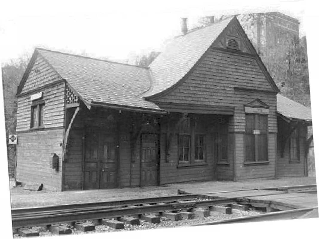
Reader John Dowling kindly shared these images and their story:

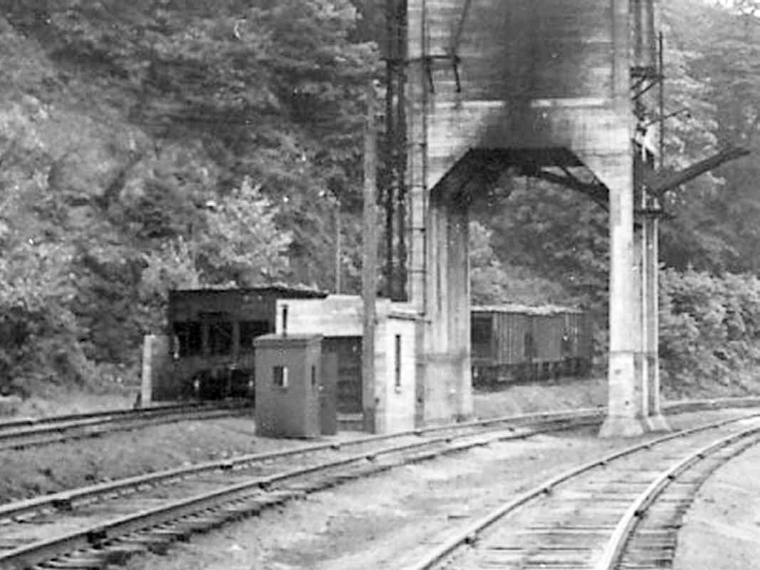
    "Shortly after I got my driver's license in 1962, I was visiting the depot and happened to meet the Ilchester station master. After he asked if I was interested in trains, he told me the building was being torn down and I could take what I wanted.

    "I (also) took the notice off the door regarding the depot's impending demise. The building's life was extended a few months after the date on the notice because it was used by the crew that was relocating the track to the center of the tunnel and (I think) increasing the tunnel's clearance. When the end came I was heartbroken."

notice 
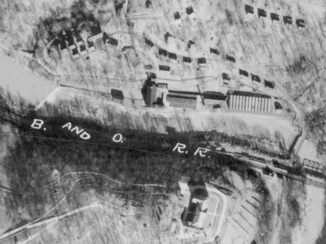
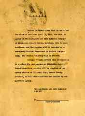
The text of that 1962 closure notice reads as follows:

"Notice is hereby given that on and after the close of business April 13, 1962, the station agency of The Baltimore and Ohio Railroad Company at Ilchester, Howard County, Maryland, will be discontinued, and the station will be operated as a non-agency station restricted to carload freight only. The station building will be retired.

"Carload freight service will continue to be provided for our patrons at Ilchester, however less-than-carload service will be provided at our agency station at Ellicott City, Howard County, Maryland, as will other business now handled by our Ilchester agency. (signed) /The Baltimore and Ohio Railroad Company/, by Superintendent."


Ilchester 1927
Photo courtesy Johns Hopkins University
NEW! late-Mar 2020

Ilchester 1927
Mile: 10.7 Date: ~1927
Ease: View: N (up)
Area: IC2:
Map: Ho 13 B 12 Topographic Maps

In 1837, a few years after B&O arrived here, the Thistle Manufacturing Company opened on the Patapsco River's north bank. During 1925, the mill Simkins Sep 2003 converted from water power to electricity. Its river dam depicted in this photo above the B of B&O would endure until removal during 2011. The mill saw a series of owners, the last being Simkins Industries (2003 photo right) that recycled paper until a 2003 fire damaged much of the facility and brought an end to 166 years of operations here. Per Wikipedia, through 1991 this was the last company town in Baltimore County. As of 2020 a few worker's homes still dot the hillside above the factory site.

In the aerial photo, visually below the railroad is St. Mary's College, with its terraced gardens.


Ilchester 1952
Photo courtesy Johns Hopkins University
NEW! late-Mar 2020

Ilchester 1952
Mile: 10.7 Date: Aug 1952
Ease: View: N (up)
Area: IC2:
Map: Ho 13 B 12 Topographic Maps

During the 1940s the mill expanded across the river to the Howard Country side, and used a conveyor to transport goods across the river between the main section and a B&O siding.

The steepness of the hills in this area discouraged further development of the town, so this aerial photo captured Ilchester near its peak.


Trucks
NEW! late-Mar 2020

Trucks
Mile: 10.7 Date: Jun 1999
Ease: B View: NW
Area: B IC2:
Map: Ho 13 B 12 Topographic Maps

Judging by the disrepair of that siding (it's buried on the right), it fell into disuse around 1970, about the time service shifted to trucks. Into the 2000s, large numbers of trailers would gather around the paper processing plant, both trackside as well as along Ilchester Road.


Retaining Wall
NEW! late-Mar 2020

Retaining Wall
Mile: 10.8 Date: Jul 2019
Ease: B View: NW
Area: B IC2:
Map: Ho 13 A 12 Topographic Maps

This has long been a trying area for the railroad, with its periodic floods and erosion issues. This wall protected both the railroad and Thistle Mill's facilities on this side of the river.


CSX 8761

CSX 8761
Mile: 10.9 Date: Oct 2000
Ease: B View: NW
Area: B+ IC2:
Map: Ho 13 A 12 Topographic Maps

As dusk approaches on a cool autumn evening, CSX 8761 leads loaded autoracks east.


Lees Water Tank
Updated late-Mar 2020

Lees Water Tank
Mile: 11.5 Date: Oct 2000
Ease: C+ View: S
Area: A IC2:
Map: Ho 12 K 11 Topographic Maps

tank Approximately midway between Ilchester and Ellicott City are the ruins of both Lees and Gray, two very small settlements. Pictured is the water tank at Lees, something easy to overlook during leaf season. Tanks were typically placed on a hillside so water could flow into tenders by gravity. B&O employed many Vanderbilt type tenders whose cylindrical shape made them sturdier and able to carry more water.

Lees had been a stop for water since the 1800s, then fell into disuse when its customers, steam engines, stopped visiting during the 1950s.


Lees
Photo courtesy John Teichmoeller collection

Lees
Mile: 11.5 Date: ~1950
Ease: C+ View: W
Area: A IC2:
Map: Ho 12 K 11 Topographic Maps

At Lees, steam locomotives took on water via the trackside penstocks in the foreground; the Lees coaling tower is seen in the background. According to Harwood in his Impossible Challenge books, the coaling tower was added during World War II to provide a locomotive refueling location outside the immediate Baltimore vicinity. Presumably this reduced overcrowding at Baltimore during the busy wartime years.


Water
Photo courtesy John Teichmoeller collection

Water
Mile: 11.5 Date: ~1950
Ease: C+ View: W
Area: A IC2:
Map: Ho 12 K 11 Topographic Maps

Streams here were insufficient to quickly refill tanks, so during the 20th century B&O added a pump house (bottom right) to filter river water and pipe it uphill to the tank.


Relics
Photo courtesy Dave Hiteshew

Relics
Mile: 11.5 Date: Feb 2008
Ease: C+ View: E
Area: A IC2:
Map: Ho 12 K 11 Topographic Maps

Despite numerous Patapsco River floods, remants of the pump house, piping, and even a utility pole all survive(d) at this spot into the 21st Century.


Coal Delivery
Photos courtesy John Teichmoeller collection

Coal Delivery
Mile: 11.5 Date: ~1950
Ease: C+ View: W
Area: A IC2:
Map: Ho 12 K 11 Topographic Maps

drop Coal hoppers were backed onto a short uphill siding siding from which they could be individually rolled toward the camera and over bins into which via gravity they would drop coal. A mechanism scooped up the dropped coal and carried it to the top of the tower.

Note the wall left of the coal hopper because...


Bins

Bins
Mile: 11.6 Date: Jan 2017
Ease: C+ View: SE
Area: A IC2:
Map: Ho 12 K 11 Topographic Maps

... it still exists, seen here from a different angle.


Lees Coaling Tower

Lees Coaling Tower
Mile: 11.6 Date: Oct 2000
Ease: C+ View: SW
Area: A IC2: 279
Map: Ho 12 J 11 Topographic Maps

The Lees tower survives too, albeit in a useless form. One source reports the railroad intentionally tipped it over during 1953 to get it out of the way.

The black mound between the tracks and tower is some leftover coal uncovered by recent CSX track work.


Lees Coaling Tower 2
Photo courtesy Gene Leache

Lees Coaling Tower 2
Mile: 11.6 Date: May 2005
Ease: C+ View: SE
Area: A IC2: 279
Map: Ho 12 J 11 Topographic Maps

Gene Leache contributed this better view of the coaling tower that he snapped during the spring.


Lees Looking East
Photo courtesy John Teichmoeller collection
NEW! late-Mar 2020

Lees Looking East
Mile: 11.7 Date: ~1950
Ease: C+ View: E
Area: A IC2:
Map: Ho 12 J 11 Topographic Maps

The steam engine's insatiable need for coal and water was a major factor in the transition to diesel-electric locomotives.


Grays Water Tank Ext
Photo courtesy Gene Leache

Grays Water Tank Ext
Mile: 11.8 Date: May 2005
Ease: B- View: SW
Area: A IC2:
Map: Ho 12 J 11 Topographic Maps

Hiding in the trees a little further west is an older water tank, this one a discovery of Gene Leache, who recalled it from his youth and found it again. The stones seen here are a retaining wall; the tank itself is a bit further up the hillside.


Grays Water Tank

Grays Water Tank
Mile: 11.8 Date: Jan 2017
Ease: C+ View: N
Area: A IC2:
Map: Ho 12 J 11 Topographic Maps

This tank was fed by a stream, and by the dry looks of things, an unreliable stream. That may explain why a tank was added not far away at Lees.

Grays is named for Edward Gray who from Thomas Mendenhall in 1812 bought a paper mill on the other (Baltimore County) side of the river. After that mill burned in 1820, Gray rebuilt as a cotton mill. When Edward Gray died in 1856, his daughter operated the business until 1888. Later the mill was purchased by the Patapsco Electric Company for the generation of electricity. The Patapsco Electric Company was organized by the same Victor G. Bloede whose name was applied to the dam downstream.


Grays Water Tank
Photo courtesy Gene Leache

Grays Water Tank
Mile: 11.8 Date: May 2005
Ease: C+ View: NE
Area: A IC2:
Map: Ho 12 J 11 Topographic Maps

Here's a view of the brick-lined interior. The wooden pieces are remnants of the tank's roof.


Mile 12

Mile 12
Mile: 11.9 Date: Jan 2017
Ease: B- View: NW
Area: A IC2:
Map: Ho 12 J 11 Topographic Maps

There's much more than just a post at mile 12...


First Tower?
Photo courtesy Dave Hiteshew

First Tower?
Mile: 12.0 Date: Mar 2007
Ease: B- View: W
Area: A IC2:
Map: Ho 12 H 11 Topographic Maps

Some reports claim this structure at milepost 12 was a "switchouse", the railroad equivalent of a canal's "lockhouse". Here was constructed the first commercial railroad track switch in the USA, one designed to connect to Ellicott Mills. Since in 1830 railroading standards did not yet exist -- some were then being established by B&O -- it's easy to envision the railroad might want an employee constantly nearby to monitor and oversee proper switching of trains. In that sense, the "switchouse" is more like a railroad tower.


Crusher Siding

Crusher Siding
Mile: 12.0 Date: Jan 2017
Ease: B- View: SE
Area: A IC2:
Map: Ho 12 H 11 Topographic Maps

However the structure is much larger than a typical canal lockhouse, suggesting it originally had, or was remodeled for, a different purpose.

These stone walls adjacent to the house are wide enough to permit passage of a rail car, and nearby is a disused B&O-style stone culvert. B&O's Form 6 from 1917 says "Crusher Siding" was here, which suggests the building was a gravel factory that loaded crushed stone into hoppers from above.


Siding Culvert

Siding Culvert
Mile: 12.0 Date: Jan 2017
Ease: B- View: N
Area: A IC2:
Map: Ho 12 H 11 Topographic Maps

Debris from the flood that tore through Ellicott City during July 2016 remains piled against this old-but-enduring culvert.

The active line, on right, gets its own circa-1830 culvert...


Culvert

Culvert
Mile: 12.0 Date: Jan 2017
Ease: B- View: N
Area: A IC2:
Map: Ho 12 H 11 Topographic Maps

... as seen here. This box culvert's stonework is a bit more regular, but the lack of mortar says its antebellum, likely constructed contemporaneously with the disused culvert of the prior photo.


Switch

Switch
Mile: 12.1 Date: Oct 2000
Ease: B- View: SE
Area: A IC2:
Map: Ho 12 H 11 Topographic Maps

This switch marked the start of a roughly half mile long siding to the mill at Ellicott City (behind the photographer).

Records indicate the first railroad bridge crossing to the factory was built around 1830.


CSX 8506

CSX 8506
Mile: 12.2 Date: Jan 2017
Ease: B- View: SE
Area: A IC2:
Map: Ho 12 H 10 Topographic Maps

Empty autoracks head back to the midwest.


Eroded
NEW! late-Mar 2020

Eroded
Mile: 12.2 Date: Jul 2019
Ease: B- View: NW
Area: A IC2:
Map: Ho 12 H 10 Topographic Maps

The floods of 2016 and 2018 ate away at the river bank. The rusty rails reveal this is not the active track, hence CSX has not bothered to shore it up.


End

End
Mile: 12.4 Date: Jan 2017
Ease: B- View: NW
Area: A IC2:
Map: Ho 12 H 10 Topographic Maps

The track that had led to the mill in Ellicott City was disconnected around 2007 to make room for new signals.


Burro

Burro
Mile: 12.5 Date: Oct 2000
Ease: B View: N
Area: A IC2:
Map: Ho 12 H 10 Topographic Maps

For years that track had served as convenient temporary storage, such as for this CSX maintenance-of-way crane BC 9611.


Signal

Signal
Mile: 12.5 Date: Jan 2017
Ease: B View: NE
Area: A IC2:
Map: Ho 12 H 10 Topographic Maps

Signals like this with heads facing opposite directions are less common.


CSX 8641

CSX 8641
Mile: 12.6 Date: Jan 2017
Ease: B+ View: NW
Area: A IC2:
Map: Ho 12 G 10 Topographic Maps

They signalled this eastbound train to proceed across a grade crossing added for a signal maintenance road. CSX 853 faces the same direction as the lead engine.


<< Previous (east) | THIS PAGE: Ilchester to Grays | Next (west) >>

Or, return to main page

Copyright Notice