


| The Callington
Branch Bridges and Level-Crossings |
||||||
|
||||||
### This Page is Under Construction ###
This page describes the Bridges and Level-Crossings of the former Callington Branch railway line. Please click here for an Index of all Callington Branch pages in RailWest.
Information about the bridges and level-crossings of the East Cornwall Mineral Railway (ECMR) is very limited and most of it has been gathered from background details in contemporary articles about the subsequent conversion and extension. Apparently there were seven public level-crossings, four manned by gate-keepers, but no signals were provided and no lights were allowed to shine in the direction of the railway from the gatekeepers' houses between sunset and sunrise.
When the new Light Railway was opened in 1908 the Inspection Report by Major JW Pringle contained a certain amount of information about both bridges and level-crossings. The line was an entirely new construction from Bere Alston to a location on the old ECMR roughly ¾ mile south of Gunnislake, but from there onwards to Callington it was essentially a reconstruction of the original ECMR infrastructure. There were also a couple of bridges on the abandoned ECMR incline line which then became redundant (click here for a 1998 picture of the underbridge at the foot of the incline).
Read below for more details about the various Bridges and Level-Crossings after 1908.
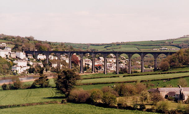
Calstock Viaduct looking east in 1998
According to the 1908 Inspection Report, on the old section of line all the bridges had been reconstructed as single-span steel structures, there being 4 overbridges and 13 underbridges. On the new extension section of line there were 4 overbridges (3 of them single-span brick arches about 15' long and the fourth being a timber footbridge) and 9 underbridges (4 of them brick arches and 5 of them formed from steel girders). On one of these underbridges just east of Calstock station at 1m 68c there is a maker's plate with the inscription "FINCH & Co Ltd ENGINEERS 1905 IRONFOUNDERS CHEPSTOW"; perhaps this company supplied the metalwork for all the bridges, but further research is necessary.
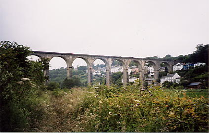
The eastward extension to Bere Alston involved the crossing of the River Tamar, which forms the boundary between Devon and Cornwall in this area. This crossing was achieved by the construction of the Calstock Viaduct, an elegant structure of 12 arches 850' long which carries the railway almost 120' above the river. Despite the abundance of granite in the area the viaduct was built from concrete, the contractors being Langs of Liskeard. Apart from some sections cast 'in situ' the bulk of the structure was constructed from a total of 11,148 individual blocks, each weighing at least 1 ton and cast from concrete at the site. The work was not without its problems and there were particular difficulties with the foundations of the piers in the river. This viaduct remains in use today as a monument to an engineering practice which was rapidly superseded by ferro-concrete.
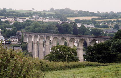
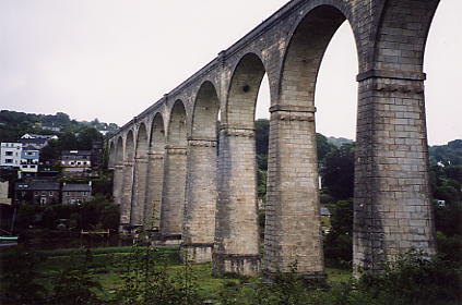
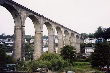
| Calstock Viaduct photographed from the Devon side in 2003 | ||||||
 |
 |
 |
 |
|||
| South side | South side | North side | North side | |||
There were several un-gated level-crossings on the railway. On the new extension there were 2 public crossings, at Okeltor (2m 28c) and Sandways (3m 31c). On the reconstructed part of the old line there were 3 public crossings, at Chilsworthy (some distance west of the station at 5m 45c), Latchley station (6m 41c) and at Phoenix (7m 0c adjacent to the later Seven Stones halt). There were also a number of private crossings.
The Light Railway Order required that speed be reduced to 10mph at 300 yards from each crossing, but the Inspection Report recommended a further reduction to 5mph at 50 yards in the following cases:-
Note: the Report merely states the mileage/chainage at which the speed board is to be erected, and it has not been possible to determine the Chilsworthy and Kit Hill entries with certainty (the status of Kit Hill as a public or private crossing also seems a little confused). A Southern Railway document of 1926 about speed restrictions at the various crossings refers to a 5 mph restriction only in the Up direction at Chilsworthy, and makes no reference to Kit Hill at all.
In some places the railway company itself imposed a more severe restriction because of the local situation. During the late-1920s the Southern Railway tried, but failed, to get approval to shorten the restricted distance to 200 yards. During their investigations they found that, in any case, many of the warning boards were not out the full distance from the crossings, but it is not clear what action (if any) was taken. Since the truncation of the branch at Gunnislake in 1966 the only public road level-crossings to remain in use are those at Okeltor and Sandways, both of which are located between Calstock and Gunnislake. All trains are required now to stop before proceeding over these two crossings.
Since the truncation of the branch at Gunnislake in 1966 several of the bridges on the closed section of line have been demolished. However a number still remain, including:-
In 1994 the old station at Gunnislake was closed and a new station was opened a few chains to the east, on the site of the former coal yard once served by Perry Spear's siding. This alteration enabled the removal of the railway bridge over the A390 road, whose low headroom had been a source of trouble for road traffic for many years.
© CJL Osment 2004
Gunnislake A390 bridge photograph © Steve Burdett
|
© West Country Railway Archives 2004 Page last updated: 29 Apr 2016 |
Home Page: http://www.railwest.org.uk E-Mail: railwest@bigfoot.com |
||||||


