


| The Callington
Branch A Description of the Line |
This page describes the route of the former Callington Branch railway line. Please click here for an Index of all Callington Branch pages in RailWest.
Map of the Callington Branch
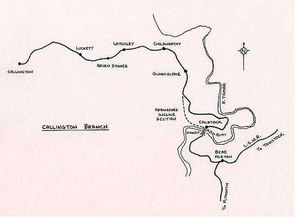
The line followed a fairly tortuous route in many places, especially over the part that formed the 1908 BA&CLR extension. From Bere Alston the line leaves in a south-west direction, but swings round north-west on a 10 chains curve and heads north-east towards Calstock, turning almost due north on a 9 chain curve to run over Calstock Viaduct into Calstock station. The station itself is on a 7 chain curve and down trains leave going east on a gradient that steepens from 1 in 264 to 1 in 37, while swinging back through 180 degrees to run due west. There follows a series of curves of average 10 chains radius as the line rise over 400 feet in the next 2½ miles to joined the original ECMR about half a mile south of the next station at Gunnislake.
From Gunnislake the line ran roughly westwards towards Callington station over a section that was slightly easier, although still with many sections at gradients steeper than 1 in 100. Because of the numerous sharp curves and steep gradients the line speed was not very high: there was an overall maximum limit of 25mph, with numerous more severe restrictions. There were several un-gated level-crossings and the Light Railway Order required that speed be reduced to 10mph 300 yards from each crossing, although in some places the railway company itself imposed a more severe restriction because of the local situation. The total length of the branch was 9 miles 60 chains.
To be continued...
© Chris Osment 2002
|
© West Country Railway Archives 2002 Page last updated: 02 Mar 2012 |
Home Page: http://www.railwest.org.uk E-Mail: railwest@bigfoot.com |
||||||


