|
Module/Owner
|
Description
|
|
Arvana
Foster Brennen
Module Diagram
|
90 deg. Corner Module
96" min. radius corner module with Cotton Gin industry.
|
|
|
Brush Creek
Adam Eastman
(OK Free-Mo, mentor, and frequent participant)
Module Diagram
|
Approximately 57" X 24" 45 deg.
45 deg. corner module. Bridge over creek.
|
|
|
Caballo Creek
Dave Dane
Module Diagram
|
Approximately 12' X 2'
Two 6' long modules. Passing siding and tail track.
A MOW/RIP siding based on DRGW trackage in the Eastern Utah high painted desert. It has a 6 foot east switch module and a 6 foot west switch module.
The 6 foot 45 degree "Caballo Curve" curve section with a creek crossing can be inserted for 18' total length.
Includes a section gang shed as well as signals and signal sheds.
|
|
|
Caballo Curve
Dave Dane
Module Diagram
|
Approximately 6' X 2' 45 deg.
45 deg. corner module. May be used within Caballo Creek for 18' total length.
|
|
|
Calumet River
Patrick Wilkinson
Module Diagram Coming Soon
|
Approximately 4' X 2' Bridge Module
Single track bridge module.
|
|
|
Copeland Bend
Tye Jackson
Module Diagram
|
Approximately 6' X 2' 45 deg.
Single track 45 deg. corner module. The scenery is inspired by an area of mailine UP track Just west of Strawn, TX. It has an oilfield location with pumpjack and tank battery on it representative of the recent boom in oil exploration and production that has occurred on the Copeland Ranch.
|
|
|
Dalwor Junction
Ryan Harris
Module Diagram
|
Approximately 3' X 2' 45 deg. wye
45 deg. Wye. Single track. Highway bridge over track.
Dalwor Junction, located approximately 1 mile due east of the Tarrant County courthouse in Fort Worth, Texas, forms the east leg of a wye constructed by the Chicago, Rock Island & Gulf Railroad nearly a century ago.
Today the trackage is owned and operated by Railtran, a joint effort of the cities of Fort Worth and Dallas, and serves the Trinity Railway Express commuter operation as well as BNSF freight operations.
Interstate 35W passes over Dalwor Junction, providing motorists with a view of both the Trinity River and the railroad.
The module features a scratchbuilt monopole billboard and a pair of scratchbuilt highway bridges based on the original 1958 concrete pier and steel beam construction.
Model of Fort Worth prototype.
|
|
|
Fort Rose and T'Pau City
Maxon Widner "Sarge"
Module Diagram Coming Soon
|
Approximately 17'6" X 2'
Double Track/Military Base.
A free-lance module which services a rail-head for the Army and a small industrial section of the city. It is serviced mainly by the Rock Island, the SDG, and the T&W RR companies.
SDG stands for the "Soli Dea Gloria".
T&W is the Texas & Widner.
|
|
|
Gunter Grain
Jacob Damron
Module Diagram
|
Approximately 18' X 2'
Three 6' long modules. Single track with passing siding, industrial lead, and 2 grain elevator tracks.
|
|
|
Liberty Lumber
Wallace Inman
Module Diagram Coming Soon
|
Approximately 6' X 26"
Double track with 2 lumber spurs.
|
|
|
May Ave.
Adam Eastman
(OK Free-Mo, mentor, and frequent participant)
Module Diagram
|
Approximately 4' X 2'
Single track. Track passes over road (May Ave.)
|
|
|
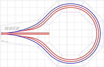
Rittaround Loop
Jeffrey Ritter
Module Diagram

|
Approximately 16' X 11' Balloon Loop
Three track loop module.
42", 45", & 48" radius loop tracks.
(Former MN.Free-Mo James J. Hill Module)
|
|
|
Saginaw Yard
North Texas Free-Mo
Module Diagram
|
Approximately 12' X 3'
Multi track staging yard. In progress. May be lengthend as needed.
|
|
|
South Plains Ethanol
Jeffrey Ritter
South Plains Ethanol Official Website
|
Approximately 4' X 26" With 12' X 4' Peninsula
Double track with 12' peninsula for Ethanol plant industrial trackage.
Two corn unloading tracks and 2 Ethanol loading tracks.
|
|
|
Tower 60
Paul Fisher
Module Diagram
|
Approximately 8' X 6'
Double track main with single track 45 deg. interchange. Includes 3 industrial spurs.
Model of Fort Worth prototype.
|
|
|
Valley Mills
Glenn Hargrave
Module Diagram Coming Soon
|
Approximately 8' X 6' 90deg. corner.
Represents the large curve outside of Valley Mills, TX on the former Santa Fe (now BNSF) main line between Galveston and Fort Worth. This line was built by the Gulf, Colorado, and Santa Fe Railway in 1881. The curve lies between mileposts 258 and 259 (from Galveston), and runs through a deep cut in the central Texas limestone. It is single track, between the sidings of Valley Mills and Manhattan. State Highway 317 crosses the Northwest end of the curve and provides a scenic vantage point to photograph trains as they round the curve and emerge from the cut. Passenger trains such as Santa Fe's Texas Chief, and Amtrak's InterAmerican and Lone Star used this line. The line sees numerous grain trains during harvest time bound for Galveston, and several manifest freights each day. A number of unit coal trains also use the line, including the train to the Smithers Lake Power Plant (UFIX).
Model of Valley Mills, TX. prototype.
|
|


 Our Modules