TrainWeb.org Facebook Page
Baltimore Trolley Line #27


Baltimore Trolley Line #27
Modern day photo tour

Accompanying each photo below are:

Click a photo to see a larger view. Please send your comments and corrections to Steve.


Background: Baltimore Trolley Line #27

Map 1948
Image courtesy Johns Hopkins University

Map 1948
Mile: Date: Jan 1948
Ease: View: N (up)
Area: BSTPY:
Map: Ba 42 H 2 (center) Topographic Maps

The 27 line's run along Washington Boulevard is illustrated by this 1948 Baltimore Transit Company system map. The dotted line indicates the rolling stock had evolved to "trackless trolleys" (electric buses) by this time.


Trackless Trolley
Photo courtesy Library of Congress

Trackless Trolley
Mile: Date: Jun 1940
Ease: A View: NE
Area: C+ BSTPY: 145
Map: Ba 42 F 4 Topographic Maps

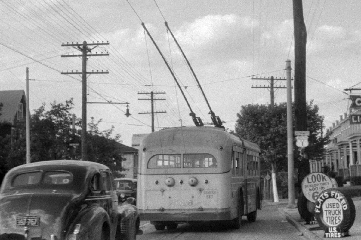
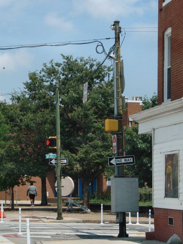
A Line 27 trackless trolley was photoed at Morrell Park. Note it has two connections to the overhead power. Since the buses rolled on insulating rubber wheels, electricity was unable to flow from the overhead wire into the ground. Two connections permitted the current to flow in from one and out via the other.

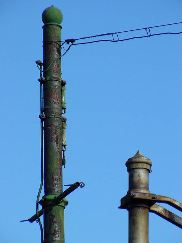
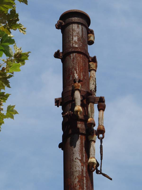
Two light-colored poles suspend the trolley wire. The one on the left has an globe-shaped top and is, I believe, older than poles topped by a flat finial, such as that at right. Look closely along the horizontal wire between the poles to find three thicker sections. Those are wooden insulators, some of which have survived into the 21st century.

Links: side view, 1922


From I-95

From I-95
Mile: Date: Jan 2022
Ease: A View: NW
Area: B BSTPY:
Map: Ba 42 J 3 Topographic Maps

Our next stop is adjacent to the former Montgomery Ward & Company warehouse. Those too young to have shopped at Ward should be aware that Ward and Sears were the mail-order giants of their day. Walmart and Amazon would later take their place.

The building has been repurposed as office space named Montgomery Park. You can see it while driving southwest from Baltimore on I-95.

The rails are not trolley leftovers but rather the ex-B&O Locust Point Branch that CSX now calls its Mt. Clare Branch. Streetcar 27 (and Washington Boulevard) crossed it at grade at the thin bright strip near railroad signals.


Aerial 1927
Photo courtesy Johns Hopkins University

Aerial 1927
Mile: Date: 1927
Ease: View: N (up)
Area: BSTPY:
Map: Ba 42 H 3 Topographic Maps

A small yard is visible right of center. It may have temporarily held B&O railcars to/from Montgomery Ward. Multiple references say this Ward building dates to 1925, though it looks more than two years old in this view. Perhaps construction was not yet finished.


Aerial 1953
Photo courtesy Johns Hopkins University

Aerial 1953
Mile: Date: Feb 1953
Ease: View: N (up)
Area: BSTPY:
Map: Ba 42 H 3 Topographic Maps

The trolley and B&O intersected at bottom center.

As of 2026, this remains the oldest, still-active grade crossing of freight rail in Baltimore City. It originated with B&O's Locust Point Branch during the 1840s. The oldest active railroad grade crossing in the world can be found a few miles west where Old Frederick Road meets B&O's/CSX's Old Main Line.

Change for: B&O Locust Point Branch tour at this site
Detour: B&O Old Main Line tour at this site


URE 8142
Photo courtesy Baltimore Streetcar Museum
and Digital Maryland

URE 8142
Mile: Date: 1925
Ease: A View: NW
Area: C BSTPY:
Map: Ba 42 H 3 Topographic Maps

United Railways and Electric's car 8142 poses outside the warehouse. The grade crossing with B&O is immediately off photo left. The tracks in the foreground belong to a small B&O yard that was removed before the 1953 aerial photo above.

Note the globe-top pole at the left edge. Below, we'll revisit it during the 21st centory.

Link: photo source


Oldest Grade Crossing

Oldest Grade Crossing
Mile: Date: Dec 2003
Ease: A View: NE
Area: C BSTPY:
Map: Ba 42 H 3 Topographic Maps

The globe-top pole in the 1925 photo above was still standing in 2003: it's the tallest pole on the left, here on duty to suspend traffic signals at the grade crossing. Railroad warning flashers are mounted on their own poles.

Diesel-powered buses replaced the electrically-powered trackless trolleys by 1960. Poles that suspended their power wires remain scattered around the city. Several have been repurposed to hold other wiring or signals.

The No Left Turn sign tells drivers to not turn onto the former B&O tracks. Signs of that style date back at least to the 1950s.

Link: early transport


Globe-Top

Globe-Top
Mile: Date: Dec 2003
Ease: A View: E
Area: C BSTPY: 30
Map: Ba 42 H 3 Topographic Maps

The separate poles become evident when viewed from a slightly different angle. I call that on the left a globe-top pole. Two wooden insulators spattered with green paint dangle from it. Does anyone know the purpose of the crossbar?

Several finial types are to be found on poles like this. Some globes are more onion-shaped than this one. Many, but not all, globe-tops are former trolley system poles. Most lamp and signal poles installed by Baltimore City during the mid-20th century are painted green.

Link: repair truck


Xing 2025

Xing 2025
Mile: Date: Feb 2025
Ease: A View: NE
Area: C BSTPY:
Map: Ba 42 H 3 Topographic Maps

The trolley wire poles disappeared when the grade crossing was modernized around 2012.


Map 1914
Image courtesy Maryland State Archives

Map 1914
Mile: Date: 1914
Ease: View: N (up)
Area: BSTPY:
Map: Ba 42 H 2 Topographic Maps

Continuing northeast from the B&O grade crossing at lower left, we find United Railways and Electric's car barn and repair shop shown in light red. That looks like a B&O - UR&E interchange track at bottom. Bayard Street is the diagonal at upper right.


MTA Shop

MTA Shop
Mile: Date: Aug 2022
Ease: A View: E
Area: C+ BSTPY:
Map: Ba 42 H 2 Topographic Maps

United Railways and Electric streetcars were repaired here at what became Carroll Park Shops. At photo time, Maryland Transit Administration called this the Bush Division and used it as a bus depot. Note the distinctive roofline and windows because they also appear in older photos.

I believe the pole at left is the same one visible at left in the 1940s photo linked below.

Links: 1940s, BTCo 5825, 7074, shop interior


Not Globe

Not Globe
Mile: Date: Aug 2022
Ease: A View: NE
Area: C+ BSTPY:
Map: Ba 42 H 2 Topographic Maps

This pole somehow escaped the green paint. This one demonstrates that some poles were not topped by a globe finial. Wooden trolley wire insulators hang on despite non-use since about 1960. Modern systems like Baltimore's light rail employ nylon insulators.

Links: 1918, buses here 1939, Brill 2163


Bayard Street

Bayard Street
Mile: Date: Aug 2022
Ease: A View: E
Area: C+ BSTPY:
Map: Ba 42 J 2 Topographic Maps

The green poles where Washington Boulevard intersects Bayard Street lack a globe on top. While not definitive proof, that lack increases the chance they were not trolley wire poles.

Link: here 1940


Ostend Street

Ostend Street
Mile: Date: Aug 2022
Ease: A View: E
Area: B- BSTPY:
Map: Ba 42 J 1 Topographic Maps

The poles at Ostend Street have globe-tops and might be trolley leftovers.

UR&E declared bankruptcy in 1933 then was reorganized in 1935 as the Baltimore Transit Company. Baltimore's last streetcars ran during November 1963.

Link: heading back to Morrell Park 1940s


UR&E Map 1929
Image courtesy Johns Hopkins University

UR&E Map 1929
Mile: Date: 1929
Ease: View: N (up)
Area: BSTPY:
Map: Ba 35 B 13 (center) Topographic Maps

UR&E published this map of its service in the downtown area. The 27 Line is at bottom left.

I hope you enjoyed this look at a tiny portion of the system.


For other tours here, select from the map: clickable map

Or, return to main page

Copyright Notice