TrainWeb.org Facebook Page
B&O Metropolitan Branch Photo Tour


B&O Metropolitan Branch
Modern day photo tour

Accompanying each photo below are:

Click a photo to see a larger view. Please send your comments and corrections to Steve.


<< Previous (east) | THIS PAGE: Washington DC | Next (west) >>

Brief Historical Background:


Washington Station
Photo courtesy Library of Congress

Washington Station
Mile: 0.0 Date: 1908
Ease: View: NE?
Area: B IC2: 96, 150, 151
Map: DC Dwn 8 C, PG 17 D 1 Topographic Maps

When the Metropolitan Branch finally in 1873 began operation, Union Station did not yet exist. Instead trains rolled to New Jersey Avenue and C Street where B&O's older, pre-Civil War station found itself in a then-new hole: at the time Washington city was in the midst of raising its swampy streets via 15 feet of landfill. The station, demolished in 1908, exhibited an architectural style similar to B&O's surviving station in Frederick, MD.

Locomotives steamed past the Capitol until politicians tired of B&O and Pennsy invading so deeply into their city, and in 1905 forced those railroads to join at Union Station, about a half mile northeast of the B&O's station.

Link: station pics


Union Station

Union Station
Mile: 0.4 Date: Jun 1999
Ease: A View: NE
Area: B IC2: 228
Map: DC Dwn 9 C, PG 17 C 2 Topographic Maps

Before the automobile and airplane made much of an impression, a grand Union Station was constructed to support trains of the Pennsylvania Railroad, Baltimore and Ohio Railroad and Southern Railway. Though the steam trains of those companies no longer chuff here, Amtrak plus commuter lines of MARC, VRE and the Washington, DC Metro system keep the station busy.

Union Station had declined in parallel with rail passenger traffic post World War II, and by the 1980s was grimy and in disrepair. Fortunately, the station was recognized for its place in history before it could be demolished: a restoration during the 1990s gave it a new vitality.

Links: Pic group, Images of Union Station


Immense
Photo courtesy Dave Hiteshew

Immense
Mile: 0.5 Date: Sep 2008
Ease: A View: N
Area: B IC2:
Map: DC Dwn 9 C, PG 17 D 1 Topographic Maps

Union Station is huge, the largest train station on the East Coast; a wide-angle lens helps capture it in one photo, but makes the walls appear to lean inward.


Fountain
Photo courtesy Dave Hiteshew

Fountain
Mile: 0.5 Date: Sep 2008
Ease: A View: NE
Area: B IC2:
Map: DC 16 D 1 Topographic Maps

This 1912 fountain memorializes Christopher Columbus. Flanking Columbus on the west side is an Indian figure, and on east side is an older man representing Europe (the Old World). The three flags behind represent Columbus' three ships. The stone inscription reads "TO THE MEMORY OF CHRISTOPHER COLUMBUS WHOSE HIGH FAITH AND INDOMITABLE COURAGE GAVE TO MANKIND A NEW WORLD BORN MCDXXXVI DIED MDIV".


The Progress of Railroading
Photo courtesy Dave Hiteshew

The Progress of Railroading
Mile: 0.5 Date: Sep 2008
Ease: A View: E
Area: B IC2:
Map: DC 16 D 1 Topographic Maps

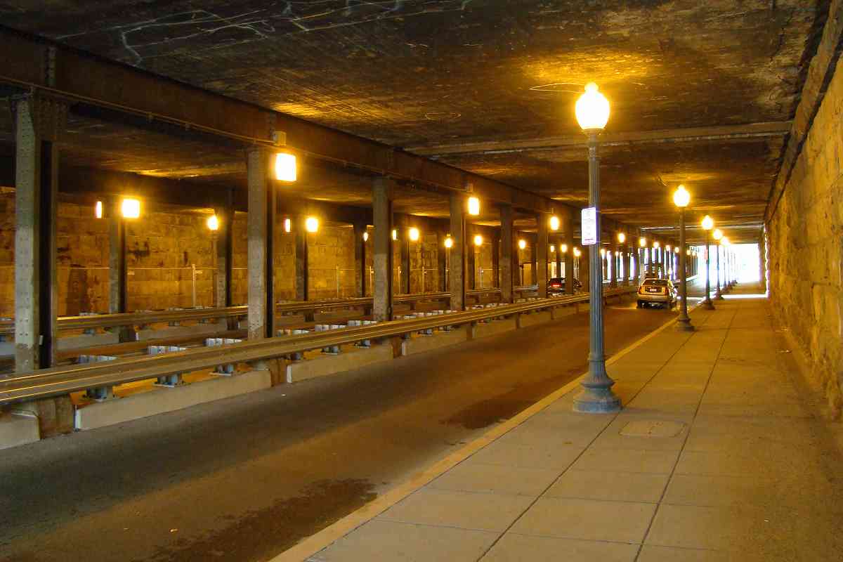
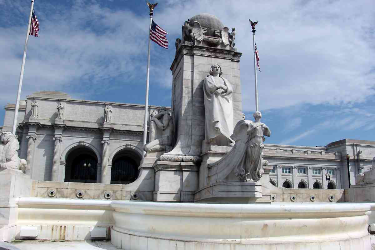
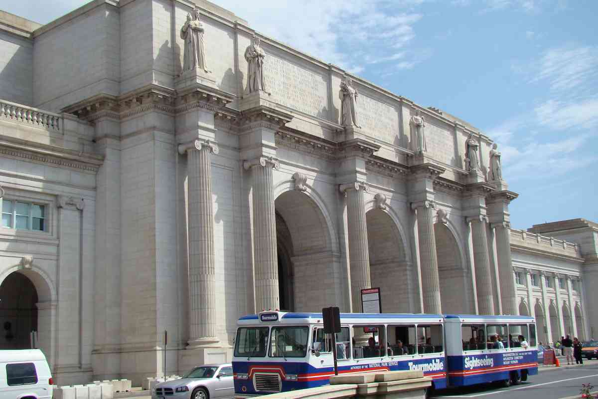
Sculptures designed by Louis St. Gaudens stand guard above the entrance to Union Station. Cut by Andrew E. Bernasconi, the 18-feet tall allegorical figures represent Archimedes - Mechanics, Ceres - Agriculture, Apollo - Imagination or Inspiration, Themis - Freedom or Justice, Thales - Electricity, and Prometheus - Fire. Accompanying aspirational inscriptions by Harvard president Charles William Eliot read with some grandiosity:

  • FIRE - GREATEST OF DISCOVERIES, ENABLING MAN TO LIVE IN VARIOUS CLIMATES, USE MANY FOODS AND COMPEL THE FORCES OF NATURE TO DO HIS WORK.
  • ELECTRICITY - CARRIER OF LIGHT AND POWER, DEVOURER OF TIME AND SPACE, BEARER OF HUMAN SPEECH OVER LAND AND SEA, GREATEST SERVANT OF MAN ITSELF UNKNOWN.
  • THOU HAS PUT ALL THINGS UNDER HIS FEET. SWEETENER OF HUT AND OF HALL, BRINGER OF LIFE OUT OF NAUGHT, FREEDOM O FAIREST OF ALL, THE DAUGHTERS OF TIME AND THOUGHT.
  • MAN'S IMAGINATION HAS CONCEIVED ALL NUMBERS AND LETTERS - ALL TOOLS VESSELS AND SHELTERS - EVERY ART AND TRADE ALL PHILOSOPHY AND POETRY - AND ALL POLITIES. THE TRUTH SHALL MAKE YOU FREE.
  • THE FARM - BEST HOME OF THE FAMILY - MAIN SOURCE OF NATIONAL WEALTH - FOUNDATION OF CIVILIZED SOCIETY - THE NATURAL PROVIDENCE.
  • THE OLD MECHANIC ARTS CONTROLLING NEW FORCES BUILD NEW HIGHWAYS FOR GOODS AND MEN OVERRIDE THE OCEAN AND MAKE THE VERY ETHER CARRY HUMAN THOUGHT.
  • THE DESERT SHALL REJOICE AND BLOSSOM AS THE ROSE.

Link: installing Thales statue 1912


Interior
Photo courtesy Dave Hiteshew

Interior
Mile: 0.5 Date: Sep 2008
Ease: B+ View: W
Area: B IC2:
Map: DC 16 D 1 Topographic Maps

No less impressive is the interior immediately inside the main entrance.

Link to older picture: ~1921


Levels
Photo courtesy Dave Hiteshew

Levels
Mile: 0.5 Date: Sep 2008
Ease: B+ View:
Area: B IC2:
Map: DC 16 D 1 Topographic Maps

What had been the basement baggage level is now a food court, while the middle level offers ticketing. Shops and other facilities occupy the level above.

In 1953, Pennsylvania RR's runaway "Federal Express" train roared into the station, collapsed the floor and fell to the baggage level, just days before crowds were expected for a Presidential inauguration.

Links: Wreck of the Federal Express, 1986 pic


Capitol
Photo courtesy Dave Hiteshew

Capitol
Mile: 0.6 Date: Sep 2008
Ease: B View: S
Area: B IC2:
Map: DC 16 D 1 Topographic Maps

As seen from the west side of the building, the station faces the US Capitol, a half mile distant.


Link
Photo courtesy Dave Hiteshew

Link
Mile: 0.6 Date: Sep 2008
Ease: B View: NW
Area: B IC2:
Map: DC 16 D 1 Topographic Maps

Railfans who go bonkers trying to figure out where this rusty link from Union Station across 1st Street leads can step across the street into the American Psychological Association building.

Reader Steve Cross, who was a GPO employee and sometimes opened the doors for the trains, kindly fills in details:

    "The bridge carries now-unused tracks into the Government Printing Office warehouse. The tracks curve to the right upon entering the building and run almost the entire length of the building on the third floor. Very sturdy construction for 1930s era." (Subsequent to that era, the GPO was renamed the Government Publishing Office.)


East Side
Photo courtesy Dave Hiteshew

East Side
Mile: 0.6 Date: Sep 2008
Ease: B View: SE
Area: B IC2:
Map: DC 16 D 1 Topographic Maps

Behind the station's east side, Amtrak trains have a choice of several platform and passageway styles.


Platforms
NEW! Sep 2020

Platforms
Mile: 0.6 Date: Jul 2019
Ease: B View: S
Area: B IC2:
Map: DC 16 D 1 Topographic Maps

At the platforms, the roofs over the passengers are the century-old station originals.

Link: train christening 1929


View North
Photo courtesy Dave Hiteshew

View North
Mile: 0.6 Date: Sep 2008
Ease: B View: N
Area: B IC2:
Map: DC 16 D 1 Topographic Maps

Turning around to look the opposite way yields an excellent view of the tracks leading to/from the station. That's the H Street "Hopscotch Bridge" crossing below.

Prior to Union Station, below was where B&O's Metropolitan Branch had split to the left from the Washington Branch. Next the Met followed what is now First Street to New York Avenue, where it zig zagged briefly along what was Boundary Avenue (now Florida Avenue), and then followed the alignment it currently does.


H Street
Photo courtesy Dave Hiteshew

H Street
Mile: 0.7 Date: Sep 2008
Ease: B View: N
Area: B IC2:
Map: DC 16 D 1 Topographic Maps

Beyond the H Street bridge at left we can see a 6-car Metro Red Line train is approaching Union Station. At right-center K Tower oversees operations.

Since the National Children's Museum is nearby, decorations were added to create the Hopscotch Bridge.

Links to older pics: 1920, 1920s


Metro Prep
Photo courtesy District Department of Transportation (DDOT) Library
NEW! Sep 2020

Metro Prep
Mile: 0.7 Date: Aug 1974
Ease: A View: NE
Area: B IC2:
Map: DC 16 D 1 Topographic Maps

signage H Street didn't always arch over the yard, it used to pass under. As seen here during the mid-1970s, first the railroad bridge was given a makeover to support DC's then-new Metro system. Soon thereafter, the H Street bridge was built, and the old underpass converted into a storage area.

The multi-font, ransom-note appearance of the sign at right, with upside-down J used for the letter r, adds an implied madman's "or else" message to the basic "keep out" one.

Link: DDOT source photo


Zoom 2008
Photo courtesy Dave Hiteshew

Zoom 2008
Mile: 0.7 Date: Sep 2008
Ease: B View: N
Area: B IC2:
Map: DC 16 D 1 Topographic Maps

A departing Metro train curls past Washington's bus depot toward another Metro train stopped at the Red Line's New York Ave, Florida Ave, Gallaudet University Station. The station's name was later simplified to NoMa. In the distance, New York Avenue crosses over the tracks.

Links station info at Wikipedia, similar ~1910s


Deep Zoom 2019
NEW! Sep 2020

Deep Zoom 2019
Mile: 0.7 Date: Jul 2019
Ease: B View: N
Area: C IC2:
Map: DC 10 E 12 Topographic Maps

The Union Station area experienced significant growth during the MARC 4912 first two decades of the 2000s. Developers wanted to acquire air rights here so they can also construct office buildings over the tracks, but then covid-19 came along and changed where many people work.

Below the catenary, MARC 4912 rushes in ahead of an approaching train being pushed by Amtrak 657. These two engines are the ones seen in the Platforms photo above which was snapped shortly after this photo.


K Street
Photo courtesy Dave Hiteshew

K Street
Mile: 0.9 Date: Sep 2008
Ease: A View: W
Area: B- IC2:
Map: DC 10 E 13 Topographic Maps

The K, L, and M Street underpasses were virtually indistinguishable from each other in their sodium-illuminated grittiness. Later mods for bike lanes gave each a unique, and more-welcoming, look.


2nd Street

2nd Street
Mile: 1.0 Date: Jul 2005
Ease: A View: N
Area: B IC2:
Map: DC 10 E 13 Topographic Maps

On the east side of the tracks, 2nd Street NE parallels while K, L and M Streets scoot underneath. Since the time of this photo, this area has been spiffed up and the road repaved and restriped.

Link: reverse view 1910s


Trackside
Photo courtesy Dave Hiteshew

Trackside
Mile: 1.0 Date: Sep 2008
Ease: B View: N
Area: B IC2:
Map: DC 10 D 13 Topographic Maps

From trackside, NoMa Metro Station appears surrounded by a web of catenary and signals. The signals are similar to B&O CPLs because B&O was tasked with signal design for the Union Station Terminal joint project it shared with the Pennsylvania Railroad.

Part of the station resides on what had been a small B&O yard between M and N Streets, east of First Street NE that saw use into the 1970s.

Links: 1917, Railfan Guide to Union Station


C Tower 1920
Photo courtesy Library of Congress
NEW! Sep 2020

C Tower 1920
Mile: 1.1 Date: ~1920
Ease: B View: N
Area: B T6:
Map: DC 10 E 13 Topographic Maps

The 1920s wins the award for Decade with the Neatest Track Ballast.

Judging by its appearance to the left of C Tower, a new bridge for New York Avenue has not yet opened to traffic.


Deeper Zoom 1977
Photo courtesy Library of Congress
NEW! Sep 2020

Deeper Zoom 1977
Mile: 0.7 Date: 1977
Ease: View: N
Area: T6:
Map: DC 16 D 1 Topographic Maps

Prior to the 2000s, where NoMa station now exists at lower left, B&O had a small yard. The railcars at right, on the near side of New York Avenue, occupy a small Pennsylvanis Railroad freight yard. By photo time it was under Conrail control. It was accessed by a single-track route under New York Avenue.

New York Avenue leaps over the tracks at photo middle. Beyond it was Eckington Yards, B&O's primary freight facility in Washington. The largest, the E Yard, extends from photo middle to the left. Even more distant, notice three groups of boxcars. The closest of those three occupied the D Yard, with the more distant ones residing in the C and B Yards.

Link: LoC source photo


<< Previous (east) | THIS PAGE: Washington DC | Next (west) >>

Or, return to main page for other tours.

Copyright Notice