TrainWeb.org Facebook Page
Old Main Line Photo Tour


B&O Old Main Line
Modern day photo tour

Accompanying each photo below are:

Click a photo to see a larger view. Please send your comments and corrections to Steve.


<< Previous (east) | THIS PAGE: disused at Henryton | Next (west) >>

Henryton - Brief Historical Background:

Approach

Approach
Mile: 24.8 Date: Sep 2005
Ease: B View: W
Area: A IC2:
Map: Ho 5 K 7, Ca 35 K 6 Topographic Maps

Since about 1850, an S-curve has led the way west into the next Old Main Line tunnel, now named Henryton. However, before then, the original right of way continued left to avoid the hill.


Mantis on Rail

Mantis on Rail
Mile: 24.8 Date: Sep 2005
Ease: B View: NE
Area: A IC2:
Map: Ho 5 K 7, Ca 35 K 6 Topographic Maps

If this little guy hopes to catch a train this way, he'd better start praying.


Looking Back

Looking Back
Mile: 25.0 Date: Sep 2005
Ease: B View: E
Area: A IC2:
Map: Ca 35 K 6, Ho 5 K 7 Topographic Maps

In this view back to the location from which the first photo was snapped, the green line marks the original alignment.


Shelf

Shelf
Mile: 25.0 Date: Sep 2005
Ease: B View: S
Area: A IC2:
Map: Ho 5 K 7, Ca 35 K 6 Topographic Maps

Despite the passage of over 150 years, a shelf of land still echoes the original alignment just prior to its crossing over the Patapsco River.


Washout

Washout
Mile: 25.0 Date: Dec 1999
Ease: B View: S
Area: A IC2:
Map: Ca 35 K 6, Ho 5 K 7 Topographic Maps

A bottleneck in the Patapsco indicates where the original alignment had spanned. A rail passenger's account dating from 1832 describes the bridge as being made of stone.

Hinting that report is correct, more than the usual number of stones litter the streambed below. Howard County is on the left, and Carroll County on the right.


Henryton Bridge

Henryton Bridge
Mile: 25.1 Date: Dec 1999
Ease: C+ View: NE
Area: A IC2:
Map: Ca 35 K 6, Ho 5 K 7 Topographic Maps

Looking back from the Carroll County side to the location at which the prior photo was snapped shows the current OML bridge spanning the river.


Cut

Cut
Mile: 25.1 Date: Dec 1999
Ease: C+ View: E
Area: A IC2:
Map: Ca 35 K 6, Ho 5 K 7 Topographic Maps

The early B&O did not make hillside cuts except where very necessary, such as at this location on the south side of the hill.

Note the narrowness of this cut, room for only one track. This, and a similar cut east of Sykesville Tunnel, are the only remaining places one can find clear evidence of the OML's original, single-track form.


Aerial 1952
Photo courtesy Johns Hopkins University
NEW! late-May 2020

Aerial 1952
Mile: 25.2 Date: Aug 1952
Ease: View: N (up)
Area: IC2:
Map: Ca 35 J 6, Ho 5 J 7 Topographic Maps

Henryton marker Henryton Tunnel is at right, below photo center. Northwest of the tunnel one finds Henryton State Hospital that opened during 1923 as a tuberculosis sanitarium.

The bright line running north/south is Henryton Road, which crossed the Patapsco River near photo bottom. Adjacent the railroad on the north side of the tracks was the hospital's power house that generated steam heat. Shadows between the tracks and river east of Henryton Road suggest B&O's Henryton Station, little more than a shack, was still standing at photo time.


Henryton
Updated late-May 2020

Henryton
Mile: 25.2 Date: Sep 2005
Ease: B- View: W
Area: B+ IC2:
Map: Ca 35 J 6, Ho 5 J 7 Topographic Maps

You can glimpse Henryton Station's concrete foundation surviving in the brush at left.

The original alignment (green line) swings from around the hill and meets the current one near the disused Henryton State Hospital power house. The hospital closed during 1985.

I found online no earlier interior photos of the power house than those below that date from September 2005. At that time the facility had been disused for 20 years but vandals had broken into the power house only shortly before.

interior The pumps and controls are fairly typical ones for an oil-fired boiler: fuel and temperature gauges, smoke monitors, timers, etc. These, with nameplate "Power and Combustion, Inc." of Baltimore, appear to date to circa 1970 when many heating plants converted from coal to oil. Then the oil crisis hit, causing many to switch to a lower grade of oil, which could be a bear to get started burning if the furance was cold. Some units employed natural gas as a starter but from the controls I saw no evidence that was done here.

control panel controls oil pumps


Henryton 2019
NEW! late-May 2020

Henryton 2019
Mile: 25.2 Date: Jun 2019
Ease: B- View: W
Area: B+ IC2:
Map: Ca 35 J 6, Ho 5 J 7 Topographic Maps

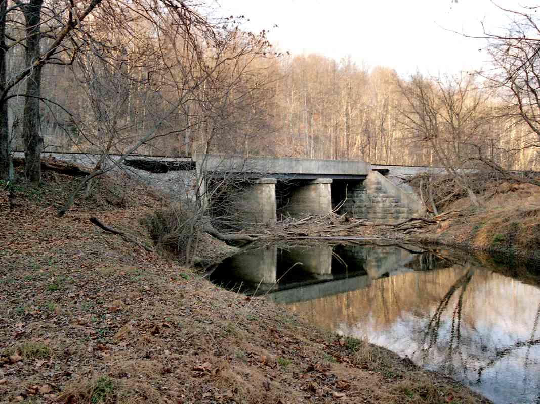
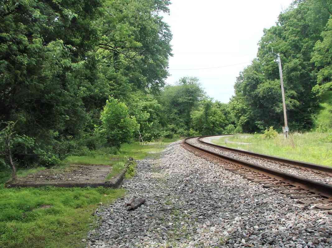
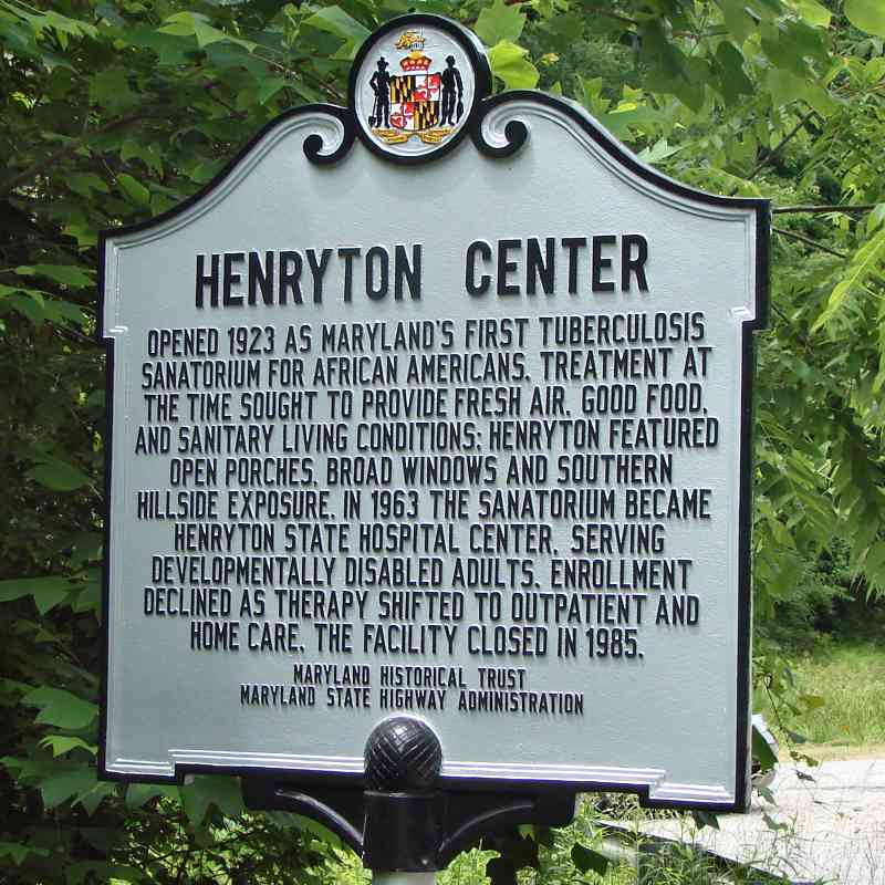
All Henryton Hospital buildings were demolished during 2013, but B&O's station foundation survives at left.

The beginning of the end for the hospital came during the mid 2000s when police seemed to tire of guarding it. We visited around 2001 while the main gate at Henryton Road was open, and found a lady sitting in a beach chair in the middle of a large parking lot. Rather than explain why the area was under guard, she acted annoyed that we were there and abruptly chased us out, admonishing us for not obeying the no trespassing sign. As we learned upon departure, that sign was not visible because it was facing inward on the gate that had been swung 180 degrees open.

Other Patapsco Park visitors likely experienced similar odd treatment, making them wonder what was going on at the old facility, thus increasing curiousity. Eventually, police could not keep up with the number of curious visitors, some of whom began to vandalize the buildings, hastening their end. Such destruction exhibits human psychology that some say reveals a feeling of inferiority or a lack of confidence. A friend likes to build small snowmen to see who kicks them down, and says from that he learns a lot about people.


Sidings

Sidings
Mile: 25.3 Date: Sep 2005
Ease: B- View: W
Area: B+ IC2:
Map: Ca 35 J 6, Ho 5 J 7 Topographic Maps

The mostly-buried rails of two power station sidings meet at an unusual angle, probably reflecting installation during two different eras. The oldest likely dates to the 1923 opening of the hospital, and presumably facilitated coal delivery. A visit in 2019 found these rails still extant.


bridge

Bridge
Mile: 25.3 Date: Apr 2001
Ease: A- View: N
Area: A IC2:
Map: Ho 5 J 7, Ca 35 J 6 Topographic Maps

The abutment at lower right is not a railroad structure, but is instead what remains of the Henryton Road bridge that was washed out in 1972's Tropical Storm Agnes.

The power house's brick chimney towers in the background.


Agnes Damage
Photo by William Schuler, courtesy Steve Schuler

Agnes Damage
Mile: 25.3 Date: Dec 1975
Ease: B- View: SW
Area: B IC2:
Map: Ca 35 J 6, Ho 5 J 7 Topographic Maps

The Henryton Road bridge lies on its side where Agnes left it.

Photo contributor Steve Schuler writes:

    "Attached is what I believe to be the Henryton Road bridge. I'd guess that Dad shot this with the railroad just to his back looking toward Howard County. There appears to be a temporary roadway next to the damaged bridge. I'm curious to see what you can dig up on this relic. Could this be 3 year old Hurricane Agnes damage that had not yet been repaired?"

Jeff Adams had seen the temporary bridge in person in 1975. He writes:

    "I believe the bridge depicted is actually a Bailey bridge (temporary) that replaced the original bridge destroyed by Hurricane Agnes in 1972. This bridge was apparently toppled by Hurricane Eloise in 1975. After that, it was decided to just close the road to through traffic. The type of bridge in the photo was used at many crossings of the river and were gradually replaced with permenant bridges, except Gaither Rd."


Landslide

Landslide
Mile: 25.4 Date: Apr 2001
Ease: B View: NW
Area: A IC2:
Map: Ho 5 J 7, Ca 35 J 6 Topographic Maps

It appears B&O used fill to create land upon which to build a straighter alignment leading to/from Henryton Tunnel. The railroad employed the same technique at Union Dam Tunnel, and just like at that location, here the Patapsco's erosive force constantly gnaws away the fill. In this photo, on a crisp spring day, a CSX track inspector checks the extent of the undermining.

On December 15, 2006 a freight train derailed near this location; the event acts as a reminder that you must use caution and be aware of the risks when exploring any of these areas. You can be severely injured or even killed if you are anywhere in the vicinity during a derailment. Such accidents are rare but they DO happen. My recommendation is to stay away unless you accept the various risks.

Link: 2006 derailment pictures


<< Previous (east) | THIS PAGE: disused at Henryton | Next (west) >>

Or, return to main page

Copyright Notice