TrainWeb.org Facebook Page
PRR / Amtrak Photo Tour


PRR / Amtrak in Maryland
Modern day photo tour

Accompanying each photo below are:

Click a photo to see a larger view. Please send your comments and corrections to Steve.


Special Note: >>> Places described on this page host quiet, high-speed trains. Stay well clear! <<<

<< Previous (northeast) | THIS PAGE: President Street Branch | Next (main line, southwest) >>

Brief Historical Background:

President Street Branch

President Street Branch
Mile: 91.9 Date: Aug 2018
Ease: A View: W
Area: B T6:
Map: Ba 36 B 12 Topographic Maps

The President Street Branch is represented here by the two tracks that curve left at photo lower left. They were the first tracks here until joined by Union Railroad (URR) about 40 years after construction. The latter is the route the Amtrak train is following. The view from I-895 is obstructed by fences.

The bright rectangle is a relatively new bridge for CSX's line to Sparrows Point.

Links: 2013, 2014
Change for: ex-B&O, CSX Sparrows Point tour at this site, URR tour at this site


Intermodal

Intermodal
Mile: 92.0, spur 0.5 Date: Aug 2016
Ease: A View: N
Area: C T6:
Map: Ba 36 A 13 Topographic Maps

The two tracks from the prior photo have divided into several by the time we can see the PSB from Lombard Street.

An NS intermodal facility operates adjacent Lombard Street as a sort of Bay View extension. The leftmost track, the one with bright ballast, supports railcar interchange with CSX.

Link: 2013


Under B&O

Under B&O
Mile: 92.0, spur 0.7 Date: Aug 2016
Ease: B+ View: NE
Area: C- T6:
Map: Ba 35 K 13 Topographic Maps

After PRR cut off B&O's track-leased access northeast of Baltimore, B&O built its own line to Philadelphia during the 1880s, including this Whipple truss bridge, the only survivor of its kind in Maryland. It is believed to be the oldest metal bridge still in use by CSX.

Change for: B&O Sparrows Point tour


Four Tracks

Four Tracks
Mile: 92.0, spur 0.7 Date: Aug 2016
Ease: B+ View: S
Area: C- T6:
Map: Ba 35 K 13 Topographic Maps

Four tracks over Eastern Avenue tell you the PSB was busier at one time. Much containerized cargo now goes directly from ship to truck, or vice versa, at the marine terminals, leaving these tracks underutilized. The PSB bridges over Eastern Avenue immediately ahead.


Over Eastern Avenue
NEW! Jul 2025

Over Eastern Avenue
Mile: 92.0, spur 0.7 Date: Jul 2024
Ease: A View: E
Area: C+ BSTPY: 115
Map: Ba 35 K 13 Topographic Maps

Grade separation circa 1930 involved rerouting Eastern Avenue slightly north to this spot. This view of PSB's bridge is one more familiar to Eastern Avenue drivers. The red bridge beyond carries the CSX line that was previously operated by B&O.


Eastern Avenue 1927
Photo courtesy Johns Hopkins University
NEW! Jul 2025

Eastern Avenue 1927
Mile: 92.0, spur 0.7 Date: 1927
Ease: View: N (up)
Area: B- T6:
Map: Ba 43 K 1 Topographic Maps

We're following the / diagonal. Grade separation at Eastern Avenue had not yet happened. 11th Street is now named Janney. The photographer of the 1915 photo below was standing near the T of EASTERN and looking east (right).


Janney at Eastern 1915
Photo courtesy Baltimore Streetcar Museum
and Digital Maryland
NEW! Jul 2025

Janney at Eastern 1915
Mile: 92.0, spur 0.8 Date: 1915
Ease: A View: E
Area: C+ T6:
Map: Ba 35 K 13 Topographic Maps

Back in 1915, PW&B's four tracks (left to right in foreground and later part of PSB) met Eastern Avenue and its UR&E trolley at this grade crossing. B&O's almost parallel line (distant dark rectangle) was grade separated from Eastern Avenue.

Crown Cork and Seal, once an active rail service customer, is on the right.

Link: photo source


Crown Cork and Seal
NEW! Jul 2025

Crown Cork and Seal
Mile: 92.0, spur 0.9 Date: Jul 2024
Ease: A- View: NE
Area: C T6:
Map: Ba 43 K 1 Topographic Maps

Crown Cork and Seal Company (right) was itself sealed between this rail line and one of B&O's. CC&S began in Baltimore in 1892 when William Painter invented the first reliable bottle cap. It sealed beer bottles with a combination of cork and steel. This basic design was employed to bottle soft drinks like Coca-Cola into the 1970s. The company expanded into can manufacture and has claimed to make one of every five beverage cans used worldwide. CC&S spread its can and cap manufacture from Baltimore to other locations around the world.

Link: CC&S at Baltimore Heritage site


Aerial 1927
Photo courtesy Johns Hopkins University
NEW! Jul 2025

Aerial 1927
Mile: 92.0, spur 1.2 Date: 1927
Ease: View: N (up)
Area: T6:
Map: Ba 43 K 2 (center) Topographic Maps

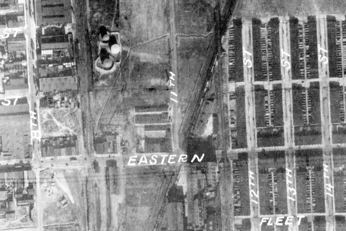
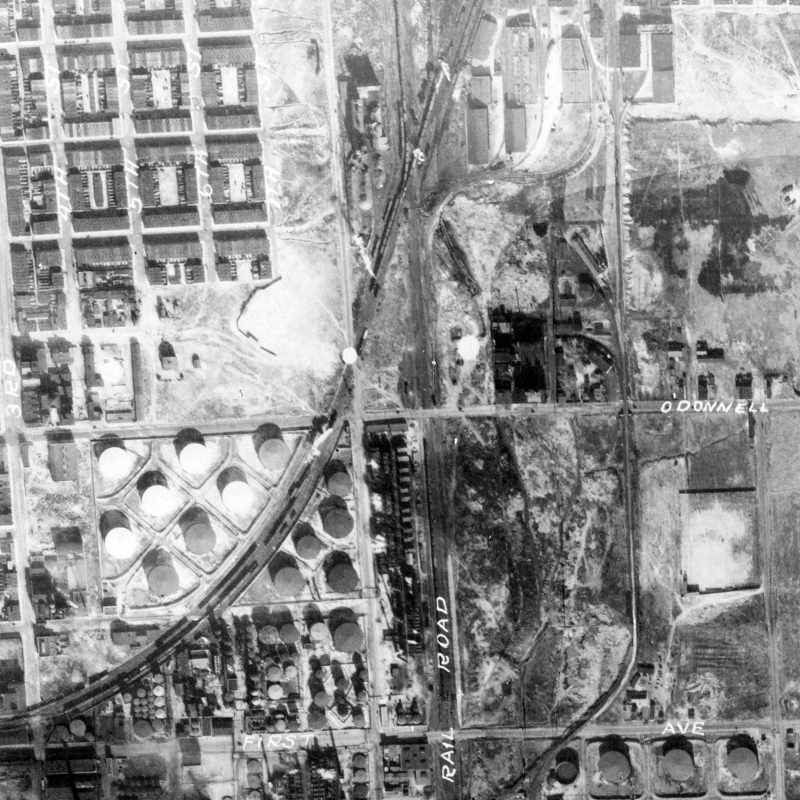
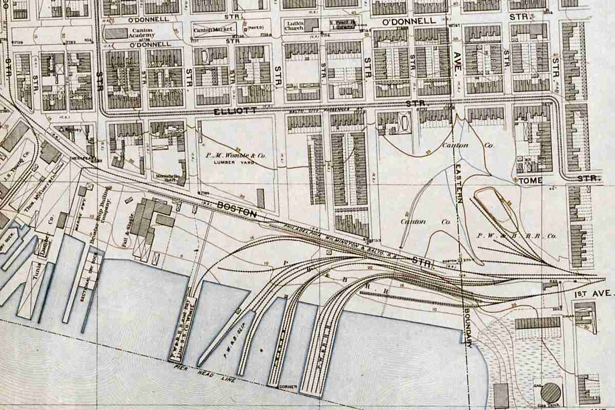
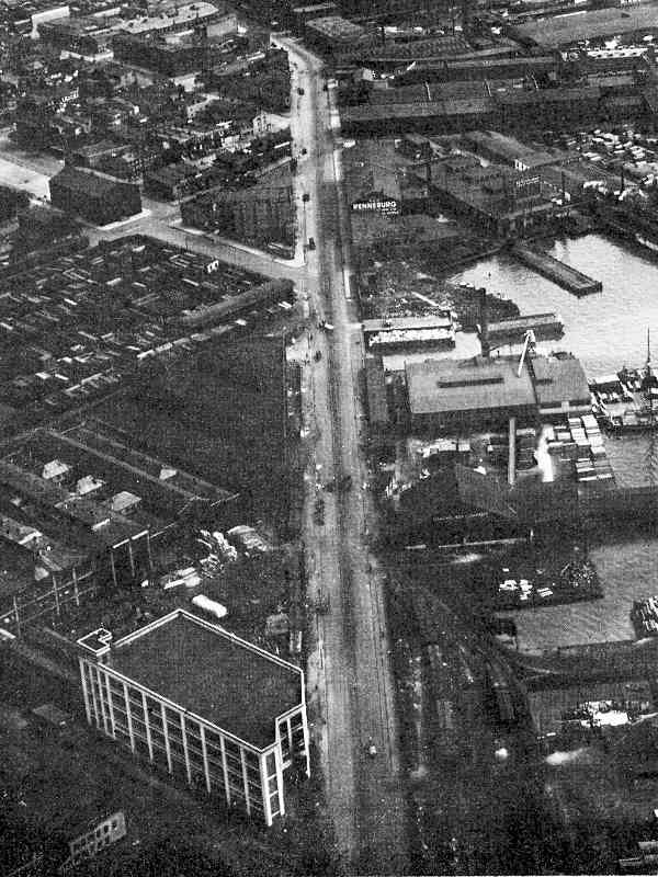
PW&B runs in the shape of the letter j from the top center of this aerial view toward the lower left where it is about to meet "First Ave", now named Boston Street.

At the "X" of tracks at top center, PW&B meets the newer URR line at a spot called Union Crossing. PW&B predated URR. URR and Northern Central/PRR became chums so they shared the route marked "Rail Road" even after URR was remade into Canton Railroad.

At photo time, PW&B continued across the NC line. Both were under the PRR umbrella, so they shared a connection at the X. PW&B traffic could turn south into Canton, as we'll see later in this tour, but originally it continued south-southwest to its Baltimore station. This tour will first follow the route to that station.


Union Crossing

Union Crossing
Mile: 92.0, spur 1.3 Date: Nov 2016
Ease: A View: N
Area: C+ T6:
Map: Ba 43 K 2 Topographic Maps

Ex-PW&B tracks west of Union Crossing saw their last train during the 1980s, and all but a short stretch of rails to cross Haven Street (next panel) were later removed. A few stranded boxcars sit at right, parallel to the still-active, ex-URR alignment to/from Canton. Subsequent to this photo, new houses were built left of center.

The route to President Street Station, which is located about 2.5 miles to the west (left), ran along Boston and Fleet Streets. Except for that station and assorted oddly-curved buildings, almost no evidence of the line remains.


Haven Street
NEW! Jul 2025

Haven Street
Mile: 92.0, spur 1.3 Date: Jul 2016
Ease: A View: N
Area: B- T6:
Map: Ba 43 K 2 Topographic Maps

This tiny bit of PW&B route hung on into the 2010s to serve a business on the west side (left) of Haven Street at Dillon Street.


Exrow Parking
NEW! Jul 2025

Exrow Parking
Mile: 92.0, spur 1.7 Date: Nov 2016
Ease: A View: W
Area: B T6:
Map: Ba 43 J 2 Topographic Maps

Some of the disused PSB has been repurposed into automobile parking.


Atlas 1894
Image courtesy Johns Hopkins University
NEW! Jul 2025

Atlas 1894
Mile: 92.0, spur 2.1 Date: 1894
Ease: View: N (up)
Area: T6:
Map: Ba 43 H 2 Topographic Maps

PW&B's main line had continued west of Canton via Boston Street and other surface streets. Even after Union Tunnel opened in 1873 and enabled passengers to reach PRR's main station at Charles Street, this route remained in use for freight purposes for about another 100 years. Many PW&B sidings curl south to waterfront docks.

That marked "P.W.&B. Slip" shows where the Transfer Bridge below can be found.


Transfer Bridge
Photo courtesy Johns Hopkins University
NEW! Jul 2025

Transfer Bridge
Mile: 92.0, spur 2.2 Date: 1924
Ease: View: SE
Area: T6:
Map: Ba 43 H 2 Topographic Maps

The Transfer Bridge at center facilitated railcar movement between land and barge. Though disused, it remains extant and surrounded by water as of 2025.

Link: video about bridge (YouTube)


Boston Street
Photo courtesy Johns Hopkins University

Boston Street
Mile: 92.0, spur 2.8 Date: 1924
Ease: View: SE
Area: T6:
Map: Ba 43 F 1 Topographic Maps

Tracks were visible along Boston Street in 1924, as well as boxcars on waterfront sidings. The tall building at lower left remains extant as of 2018 at the corner of Boston and Hudson Streets, with "The Can Company" painted on its corner and an Outback Steakhouse occupying its bottom floor.


Wood Stringers
Photo credit HH Harwood

Wood Stringers
Mile: 92.0, spur 3.7 Date: 1998
Ease: View: ?
Area: B T6:
Map: Ba 43 D 1 Topographic Maps

Sewer work at the east side of President Street Station uncovered old track made with wooden stringers presumably to which iron strap rail had been affixed. This style of track was tried during the 1830s after which it quickly fell out of favor due to lack of durability. This may be track built by B&PD before it merged into PW&B.


President Street Station
Photo courtesy Google

President Street Station
Mile: 92.0, spur 3.7 Date: Oct 2017
Ease: A View: SE
Area: B T6:
Map: Ba 43 D 1 Topographic Maps

By more westward street running, ultimately PW&B reached its Baltimore passenger station at President and Fleet Streets. Horse-drawn carriages shuttled travellers between here and B&O at Mount Clare and Camden Station.

The 1849-constructed building is the oldest surviving rail terminal in the United States; Ellicott City Station is older, but no longer a terminal. During 1861 riots, it saw some of the earliest bloodshed of the American Civil War, and now houses a Civil War Museum. A burgeoning Harbor East development during the 21st century brought several high rises to the area.

Links: 1936, 1974


Canton Junction
Photo courtesy Todd Sestero

Canton Junction
Mile: 92.0, spur 1.6 Date: 1972
Ease: A- View: S
Area: C- T6:
Map: Ba 43 K 2 Topographic Maps

semaphore 2016 To finish this page, we'll jump back to near Union Crossing and instead head south, as NS trains now do, rather than west. About 0.3 miles south, the tracks reach another former crossing, that of B&O, which is depicted in this 1972 photo. Two semaphore signals hung on here into the 1970s. Both signals are gone, but one of their poles survives, now obscured by vines (right). These photos both look generally south into Canton Yard now shared by CSX and Norfolk Southern. The primary 21st century traffic consists of coal being hauled to CONSOL Energy's export pier in the distance.


Coal

Coal
Mile: 92.0, spur 2.1 Date: Nov 2018
Ease: A View: S
Area: B T6: 300
Map: Ba 44 A 4 Topographic Maps

Sometimes hoppers stack up waiting to be unloaded at CONSOL.


Coal Hill

Coal Hill
Mile: 92.0, spur 1.9 Date: May 2017
Ease: A View: S
Area: C+ T6:
Map: Ba 44 A 3 Topographic Maps

All that coal has to be held somewhere until the next ship arrives. It is piled into 70-foot mounds like the one seen in the background from Penn Mary Yard almost a mile away. That's CTN 1204 and CTN 1307 in the foreground, both belonging to the Canton Railroad, a Class III switching and terminal railroad that operates at the port.

Change for: Canton Railroad tour


Waiting
NEW! Jul 2025

Waiting
Mile: 92.0, spur 2.5 Date: May 2023
Ease: A View: S
Area: B- T6:
Map: Ba 44 A 4 Topographic Maps

Trains of waiting hoppers can span more than a mile.


Black Sun
NEW! Jul 2025

Black Sun
Mile: 92.0, spur 2.5 Date: May 2023
Ease: A View: SW
Area: B- T6:
Map: Ba 43 K 5 Topographic Maps

Long ago, I visited a business client up near the Arctic Circle. This photo reminds me of the bleak scene of their mining operation, except many square miles looked like this. That experience encouraged me to move toward other industries.

A few CSX engines wait in the distance, left of center.

Link: tar sand mining


From Keith Avenue

From Keith Avenue
Mile: 92.0, spur 2.6 Date: Jul 2016
Ease: A View: SW
Area: B T6: 304
Map: Ba 43 K 4 Topographic Maps

The coal holding area at the waterfront occupies more than 40 acres.


CONSOL
Screen capture (fair use)
NEW! Jul 2025

CONSOL
Mile: 92.0, spur 2.7 Date: 1998
Ease: View: N
Area: T6:
Map: Ba 43 K 5 Topographic Maps

A better view of the coal yard can be had via the film Enemy of the State.

Change for: more screen captures within CTN tour


Salt

Salt
Mile: 92.0, spur 1.9 Date: Jul 2016
Ease: A View: SE
Area: C+ T6:
Map: Ba 43 J 3 Topographic Maps

Coal is not the only bulk material delivered via train. Equally large mounds of salt wait for the next icy winter.


From I-95

From I-95
Mile: 92.0, spur 2.5 Date: Aug 2017
Ease: A View: N
Area: B T6:
Map: Ba 43 K 4 Topographic Maps

As seen from I-95 near the Fort McHenry Tunnel, huge salt mounds make tankers look small enough to be models. The branch now ends in this vicinity as a loop to ease the return of empty hoppers. The tall building belongs to CareFirst in Canton.


<< Previous (northeast) | THIS PAGE: President Street Branch | Next (main line, southwest) >>

Or, return to main page

Copyright Notice