TrainWeb.org Facebook Page
Trolley Photo Tour


Rhode Island Avenue Trolley
Modern day photo tour

Accompanying each photo below are:

Click a photo to see a larger view. Please send your comments and corrections to Steve.


<< Previous (west) | THIS PAGE: Beltsville to Laurel | End of tour || main index

US 1 Then
Photo credit HH Harwood

US 1 Then
Mile: Date: 1948
Ease: View: N
Area: IC2:
Map: PG 7 H 3 Topographic Maps

Simpler times, or Outer Mongolia? At the US 1 (Baltimore Avenue) grade crossing in Beltsville a grand total of three autos await a green signal from the simple overhead traffic light as a trolley glides past. Note the single track.

The short fence in the foreground, also seen back at Madison Street, must have served a dual purpose: to indicate a trolley stop, as well as provide a crude seat for those waiting.


US 1 2004

US 1 2004
Mile: Date: Apr 2004
Ease: A View: N
Area: B IC2:
Map: PG 7 H 3 Topographic Maps

Now: more cars, more wires, more traffic signals, but fewer trolleys.

From this point north, the ROW remains on the west side of US 1 and generally parallels it.


South of US 1 Then
Photo credit HH Harwood

South of US 1 Then
Mile: Date: 1948
Ease: View: SW
Area: IC2:
Map: PG 7 H 3? Topographic Maps

Harwood turned to look the opposite direction and snapped this view of CTC 372. The ad says "Your Fresh-Up 7 Up". The building on the right appears to be Bart's Service Station (the fuzzy lettering might instead read Jack's or Jake's).


South of US 1 Now

South of US 1 2004
Mile: Date: Apr 2004
Ease: A View: SW
Area: B IC2:
Map: PG 7 H 3 Topographic Maps

Now: The utility poles have been shifted left to make room for Rhode Island Avenue, and the Service Station lives on as a Jiffy Lube. The side of the building is now obscured by a parking facility, but its roof retains a notably similar design.


Beltsville Then
Photo courtesy HH Harwood collection

Beltsville Then
Mile: Date: 1947
Ease: View: NE
Area: IC2:
Map: PG 7 J 1 Topographic Maps

CTC 374 pauses at Beltsville "Terminal". There was no terminal building, of course, instead Odell Road was simply the end of the line at the time of this photo. I believe service to points further north was eliminated in 1925.

For future reference, note the chimneyed house hiding behind the trolley car.

Reader Vernon Tyler contributed:

    "While I do not have the volume, the Leroy King DC streetcar history likely provides an exact date of end of operations between Laurel and Beltsville."


Beltsville 2004

Beltsville 2004
Mile: Date: Apr 2004
Ease: A View: NE
Area: B+ IC2:
Map: PG 7 J 1 Topographic Maps

Now: The trolley's gone, but the chimneyed house remains at the intersection of Odell Road and Rhode Island Avenue.

The white house at the right side of the Then photo above would have been visible in this more recent photo had the pine tree not been in the way.

On again, off again Rhode Island Avenue ends for good two blocks ahead.


Mt Rainier Bound
Photo credit HH Harwood
NEW! mid-Mar 2024

Mt Rainier Bound
Mile: Date: 1948
Ease: View: N
Area: IC2:
Map: PG 7 J 1 Topographic Maps

This trolley will soon head south to Mt. Rainier, a Maryland neighborhood along Rhode Idland Avenue immediately outside Washington, DC.

Link: ~1950


Path

Path
Mile: Date: Mar 2004
Ease: B View: NE
Area: B IC2:
Map: PG 3 J 13 Topographic Maps

For a short distance after Rhode Island Avenue expires, the trolley ROW has been maintained as a sort of walking path between houses on the north side of Beltsville.

There's a small stream ahead (Indian Creek), but any vestiges of a trolley bridge were removed when in the 1960s a concrete streambed was added. After that the ROW becomes wooded.

Over 75 years have passed since the last trolley did so here, but there are still a few artifacts to be found if you know where to look. We'll continue our search northeastward.


Arched Bridge

Arched Bridge
Mile: Date: Mar 2004
Ease: B+ View: E
Area: A IC2:
Map: PG 3 K 12 Topographic Maps

Hiding untouched in the woods on the south side of Ammendale Road is this prize: the only surviving trolley stone and brick arch bridge (at least that I have found). It appears to be wide enough to have hosted double track.


Bridge Closeup

Bridge Closeup
Mile: Date: Mar 2004
Ease: B+ View: NE
Area: A IC2:
Map: PG 3 K 12 Topographic Maps

Like an old man losing his teeth, the bridge is losing its war with both time and trees. This is an excellent illustration that brick arches are not as durable as stone arches. Old B&O stone arched bridges that have been disused for longer than this bridge survive in better shape than this one.

In the distant left through the trees, offices of the Ammendale Business Campus can be glimpsed across Ammendale Road. With a nod to local history, an even newer office complex a short distance west of here on Ammendale Road has chosen to name its access road Trolley Lane.


East Side

East Side
Mile: Date: Jan 2021
Ease: B+ View: NW
Area: A IC2:
Map: PG 3 K 12 Topographic Maps

The bridge's east side is in slightly better condition.


ROW Gap

ROW Gap
Mile: Date: Mar 2004
Ease: A View: SE
Area: B+ IC2:
Map: PG 4 A 11 Topographic Maps

In the Muirkirk vicinity, both the Ammendale Business Campus and the Konterra Business Campus now sit atop the trolley right of way, obliterating it. Vehicles and billboards on US 1 can be seen in the distance.

But, wait, what's this in the campus parking lot? A break in the curb where none should be? That's enough to pique the curiosity of your photo tour guide. See the next item...


ROW Map

ROW Map
Mile: Date:
Ease: View:
Area: IC2:
Map: PG 4 B 11 Topographic Maps

On this Maryland State Highway Administration map, note the strip of land I've highlighted with red. That's the disused trolley ROW, still on the books.

It aligns perfectly with the location of the curb gap. I bet the construction guys saw the dashed lines on their map, and decided that meant a road was planned, so they dutifuly left a gap in the curb!


Maryland National Memorial Park

Maryland National Memorial Park
Mile: Date: Jan 2003
Ease: A View: SW
Area: B+ IC2:
Map: PG 4 C 9 Topographic Maps

It's somehow appropriate that the longest, mostly undisturbed stretch of trolley ROW lies in a cemetery. This view looks southwest back toward Muirkirk and Beltsville. The slight gap in the trees in the distance does indeed appear to be a continuation of the ROW.


Cemetery

Cemetery
Mile: Date: Jan 2003
Ease: A View: NE
Area: B+ IC2:
Map: PG 4 D 8 Topographic Maps

Look on a map: the road within the cemetery that parallels US 1 is the trolley's ROW.


Driveway

Driveway
Mile: Date: Mar 2004
Ease: A View: SW
Area: B+ IC2:
Map: PG 4 D 7 Topographic Maps

A long, tree-lined driveway marks the ROW at Contee Road.


Mulberry St

Mulberry St
Mile: Date: Mar 2004
Ease: A View: NE
Area: B IC2:
Map: PG 4 E 6 Topographic Maps

Mulberry Street heads slightly more north (left) than the trolley had from this spot. Ahead, the northern part of Laurel Lakes Shopping Center (right) occupies the former right of way.


Aerial 1938
Image courtesy Johns Hopkins University
NEW! mid-Mar 2024

Aerial 1938
Mile: Date: 1938
Ease: View: N (up)
Area: IC2:
Map: PG 4 F 5 (center) Topographic Maps

The trolley (green line) crossed Cherry Lane at what is now Laurel Place. At photo time, the line ran not quite parallel to US 1 while crossing Laurel Sanitarium's front lawn.

Links: Sanitarium photo, Laurel Sanitarium


Cherry Lane
NEW! mid-Mar 2024

Cherry Lane
Mile: Date: Dec 2023
Ease: A View: N
Area: B IC2:
Map: PG 4 F 5 Topographic Maps

There, beneath the blue suburban skies, Cherry Lane's walking path (photo bottom-left) adjacent Laurel Lake traces the trolley's route. North from Cherry Lane, Laurel Center Mall has erased the right of way. Giant Food sits where the trolley had operated. North of there, the trolley followed 6th Street.


6th St

6th St
Mile: Date: Mar 2004
Ease: A View: N
Area: B+ IC2:
Map: PG 4 G 3 Topographic Maps

It's not obvious, but north of MD 198 in Laurel, 6th Street now marks the ROW. This view is at the intersection with Carroll Avenue.

It was from here that during 1909 the Brewster Park Hotel was dragged south along the trolley rails to move it to the Laurel Sanitarium, now the site of tall apartment buildings along Ashford Boulevard. A process that was supposed to need two days instead shut the trolley for two weeks.

Links: hotel move, Brewster Park Hotel


Opening Day
Photo courtesy Laurel Historical Society
NEW! mid-Mar 2024

Opening Day
Mile: Date: 1902
Ease: A View: E
Area: B+ IC2:
Map: PG 4 G 2 Topographic Maps

Don't worry, underneath they were all wearing "I heart Laurel" t-shirts.

Link: source photo


Laurel Station 1908
Photo courtesy Maryland Historical Society

Laurel Station 1908
Mile: Date: 1908
Ease: A View: NE
Area: B+ IC2:
Map: PG 4 G 2 Topographic Maps

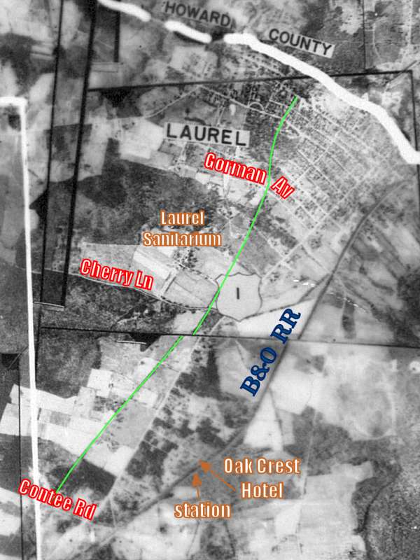
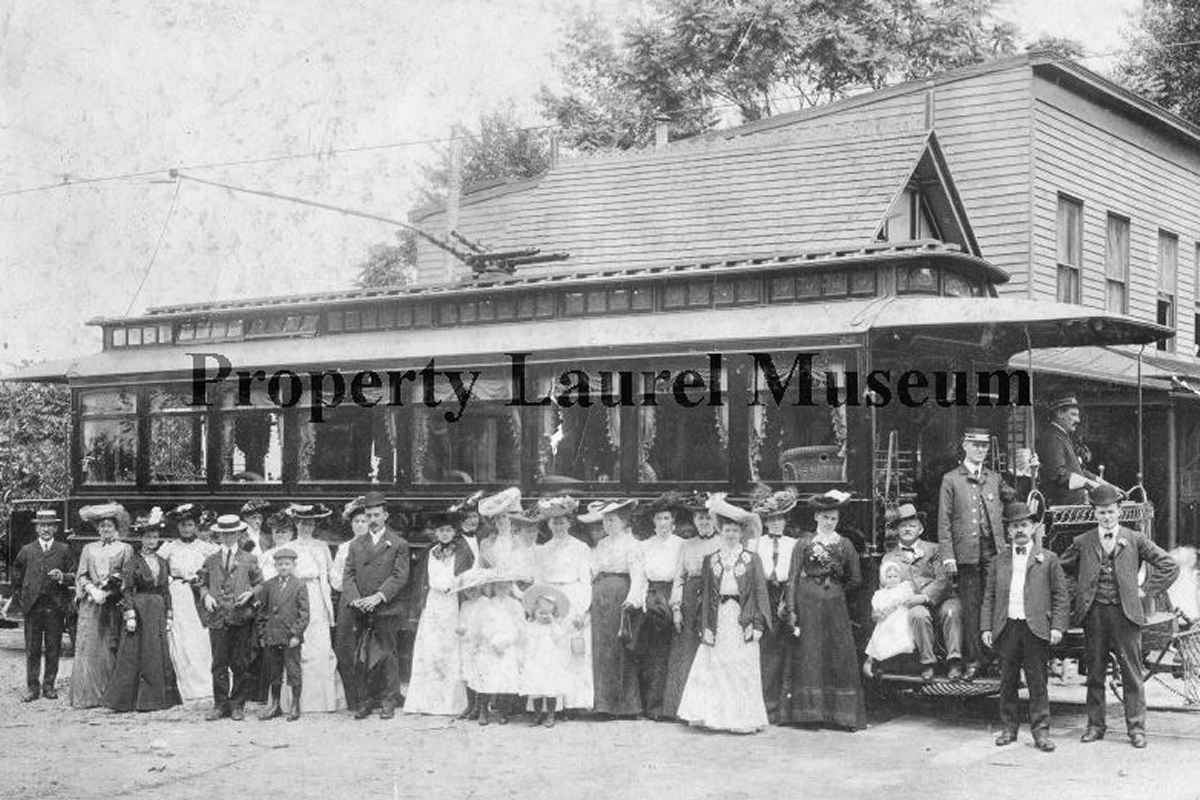
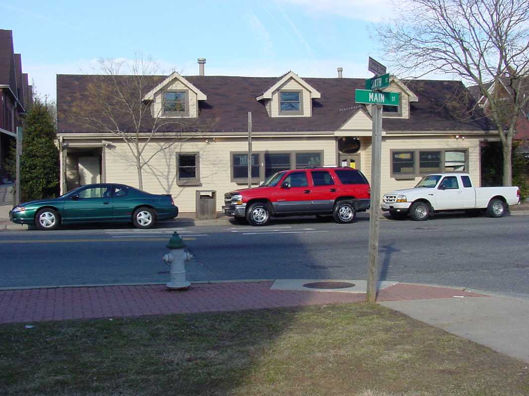
By 1902, the trolley company had reached Laurel, about 15 miles from Washington DC, and built this terminal at 6th and Main. One accident involved the trolley failing to stop, and rolling down to the Patuxent River.

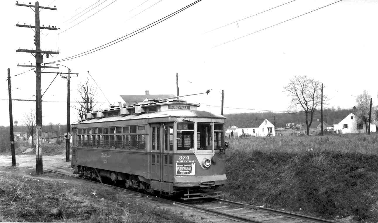
During the early 20th century, anticipating that few people would want the newfangled invention called the automobile, the trolley company made grand plans for an interurban line that would continue northeast to Annapolis Junction, and/or connect with the Catonsville - Ellicott City trolley, which was operated by an associated corporation.

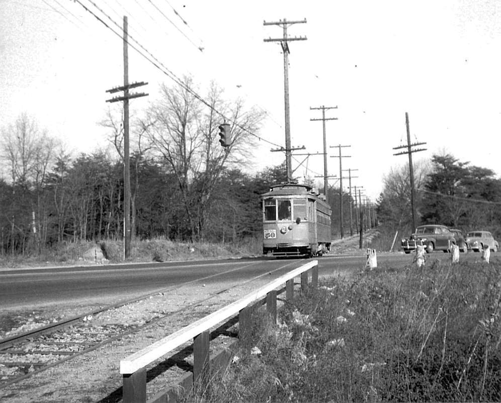
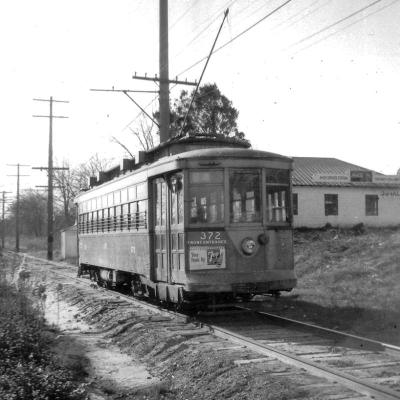
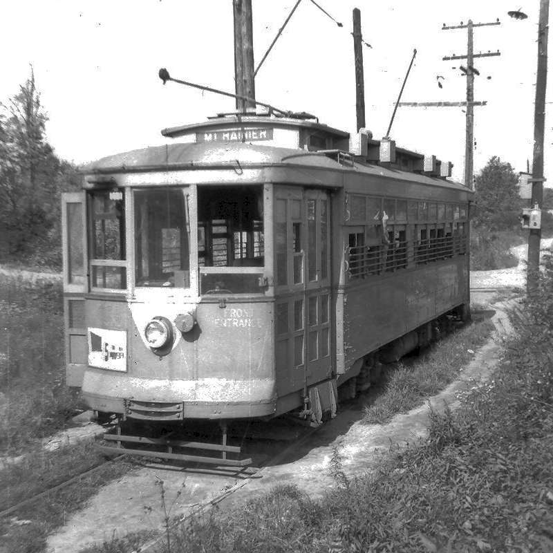
By comparison to Prince George's County, Howard County to the north was relatively deserted. The lack of demand plus the rise of the automobile squelched extension plans. Instead, during the first half of the 20th century, the trolleys were gradually shifted from private to public holdings, and then supplanted by buses.

Link: 1902 opening, 1908


Laurel Station

Laurel Station
Mile: Date: Mar 2004
Ease: A View: NE
Area: B+ IC2:
Map: PG 4 G 2 Topographic Maps

Sometime after trolley service ceased in 1925, the building was rotated 90 degrees but it still serves customers: at photo time it housed Main Street Sports Grill.

As the years passed, the end of the line retreated south from Laurel to Beltsville to Branchville and, then finally in 1962, all streetcar service in Washington, DC ceased. But, as this tour has shown, their rights of way and other artifacts survive to the present in many forms.

More trolley information:


<< Previous (west) | THIS PAGE: Beltsville to Laurel | End of tour || main index

For more tours here now, select from the map: clickable map

Or, return to main page

Copyright Notice