TrainWeb.org Facebook Page
WB&A Photo Tour


Washington, Baltimore and Annapolis Railway
Modern day photo tour

Accompanying each photo below are:

Click a photo to see a larger view. Please send your comments and corrections to Steve.


<< Previous (index) | THIS PAGE: Washington DC to Patuxent River | Next (northeast) >>

Brief Historical Background: WB&A

Map 1937

Map 1937
Mile: Date: 1937
Ease: View: N (up)
Area: EH:
Map: Topographic Maps

In many places, electric interurban railways were the first to string power-carrying wires outside the big cities. With electricity so close, it was inevitable that towns along the line would request, and purchase, power from the railways.

As this electricity distribution map from 1937 shows, the service grid is perhaps the primary legacy of the interurbans. Power lines follow many of the long-disused railways even today, then branch off along spurs or state roads.

The blue green line highlights the route of WB&A's main line that this tour follows from bottom left to upper right.


Map 1945

Map 1945
Mile: Date: 1945
Ease: View: N (up)
Area: EH:
Map: Topographic Maps

WB&A's eastward (right) route out of DC that it shared with streetcars is shaded in blue-green. Note that this topo map background dates to 1945, a decade after WB&A had ceased service, by which time service was exclusively provided by Capital Transit Company streetcar Route 12.

The location of each of WB&A's three DC terminals is indicated. Even though chronologically it was not the first terminal, for tour purposes it is logical to begin at the westernmost of those three.


Westernmost
Photo credit unknown

Westernmost
Mile: Date: 1910s
Ease: A View: NE?
Area: A EH:
Map: DC 15 K 1 Topographic Maps

Siting of a rail terminal was anything but simple in Washington, DC. By the time WB&A arrived in town, Washington already had its own streetcar lines, political interests at many levels, lingering fear of the uncertain powers of electricity, and other concerns.

To reach deep into downtown, WB&A shared rails with the Washington Railway & Electric's Columbia line streetcars. WB&A trains rode west along New York Avenue to between 14th & 15th Streets NW, about 1000 feet east of the White House. WB&A had no actual terminal building in the vicinity until 1921, so passengers simply boarded from the street as in this photo. When service began, the round trip fare between Washington and Baltimore cost $1.25, rising to $2.37 in 1926.


Terminal
Photo credit John J. Bowman

Terminal
Mile: Date: 1930s
Ease: A View: W
Area: B EH: 122, 124, 230
Map: DC 17 C 1 Topographic Maps

Growth in DC associated with World War I made the 15th Street location a busy and passenger-unfriendly one, consequently during 1921 WB&A opened a terminal a few blocks northeast at New York Avenue between 11th and 12th Streets, NW. Finally passengers could board trains from a station designed for that purpose rather than from a busy street.

wba 100 wba 60

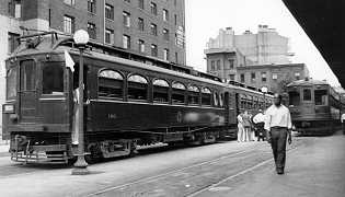
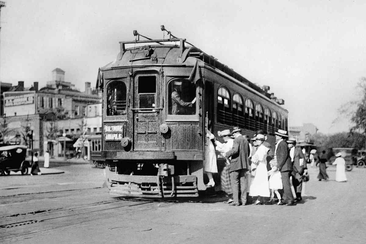
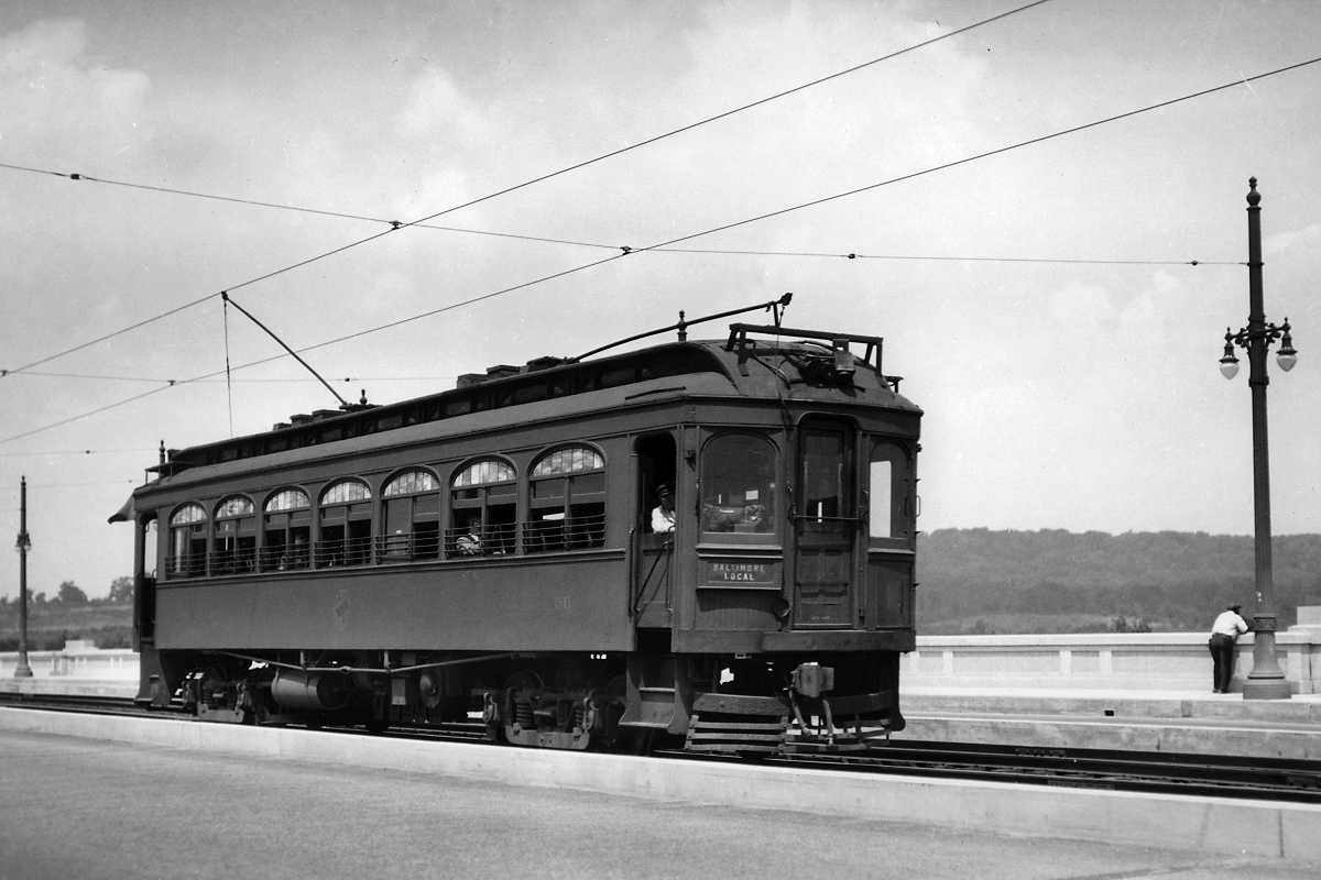
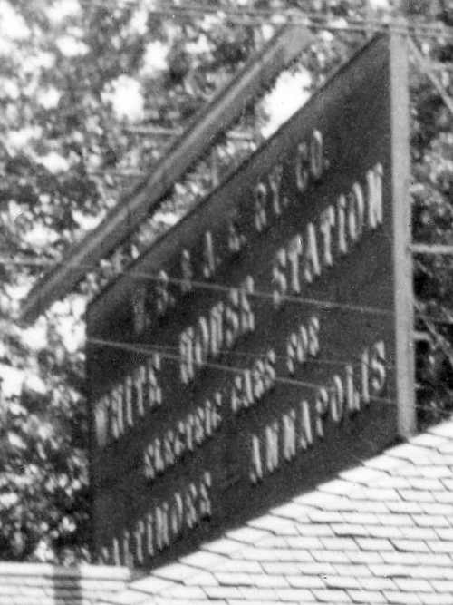
The large text on WB&A car 60 reads:

Most Direct Service
Eastern Shore of Maryland
Via W.B.&A.E.R.R.
Annapolis And Claiborne Ferry

6 Trains Daily From And To
Washington and Baltimore
Operate to Ferry Wharf Annapolis

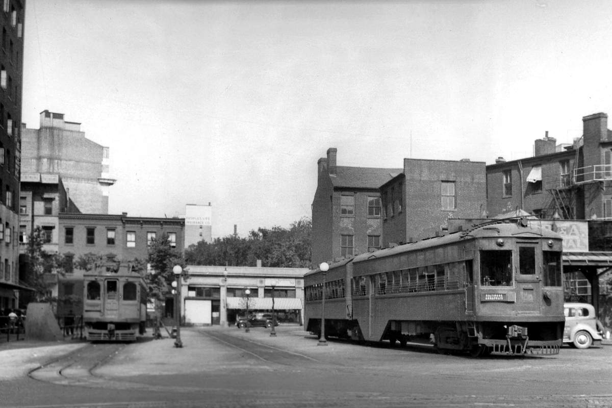
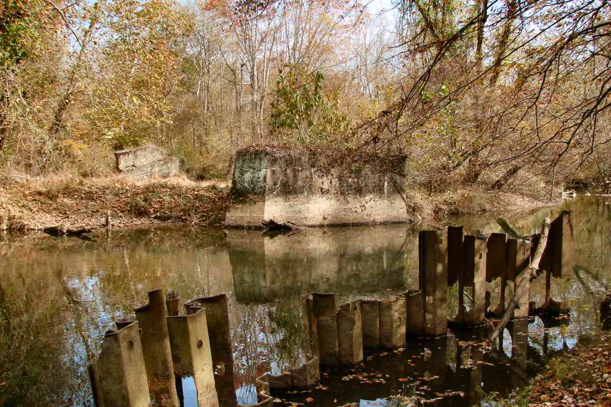
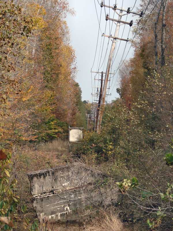
This terminal would be converted for Greyhound Buses after WB&A shuttered during 1935. Somewhat similarly, Claiborne Ferry, that crossed the Chesapeake Bay, was put out of business when the Chesapeake Bay Bridge opened in 1952. Hotel Annapolis, adjacent on the north (left, in main photo), was torn down during 1988 to make room for an office building. 
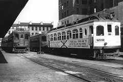
Additional photo credits: left, unknown, circa 1935; right Howard E. Johnston, August 1932.


Massachusetts Avenue
Photo credit John B. Yeabower

Massachusetts Avenue
Mile: Date: 1935
Ease: A View: E
Area: B EH:
Map: DC 16 B 1 Topographic Maps

You might notice the lack of catenary at Massachusetts Avenue and 5th Street, NW. DC law required the power source to be underground, hence WB&A cars such as 204 were equipped for electric supply from both overhead or below-ground conduit, one at any given time. Trains made the awkward, manual switch of power source at 15th and H Streets, NE, a site, in a bit of puffery, WB&A had called White House Station.


Union Station
Photo courtesy Dave Hiteshew

Union Station
Mile: Date: Oct 2008
Ease: A- View: NE
Area: B+ EH:
Map: DC 16 D 1 Topographic Maps

Before reaching White House Station, there was another station of some importance along the way...

Washington, DC's Union Station opened one year before the arrival of the WB&A. While WB&A's larger cousins, B&O, Pennsylvania, and Southern railroads, served the station directly, WB&A stopped behind (northeast of) it along H Street, a route now plied by buses such as the eastbound one seen here. During the WB&A era, H Street traversed Union Station's yard via an underpass rather than a bridge.

Links: H Street underpass photos circa 1960


White House Station
Photo courtesy Library of Congress

White House Station
Mile: Date: ~1908
Ease: A View: N?
Area: C+ EH: 22, 121
Map: DC 16 H 1 Topographic Maps

Yes, there was a physical WB&A station at 15th and H Streets (where they are now joined by Benning Road, Maryland Avenue, Florida Avenue, and Bladensburg Road), sign but it was almost 3 miles from the White House occupied by U.S. Presidents. It served as terminal from 1908 to 1910.

The rooftop sign reads:

W. B. & A. E. RY. CO.
WHITE HOUSE STATION
ELECTRIC CARS FOR
BALTIMORE ANNAPOLIS

At the time of this photo, WB&A's original rolling stock was too heavy to continue west along the conduit (underground) power stretch of track, hence passengers had to change trains to continue their journey. With car modifications plus standardization of the electricity to 1200 volts direct current, WB&A cars were able to continue west starting during 1910.


1948 Aerial
Photo courtesy DDOT

1948 Aerial
Mile: Date: ~1948
Ease: View: NE
Area: EH:
Map: DC 16 H 1 Topographic Maps

This aerial captures H Street's streetcars during their final years. That's Maryland Avenue running from photo bottom to top. White House Station had been located between those two roads; in this view that's the upper right pie slice.


DC Streetcar
Photo courtesy Google

DC Streetcar
Mile: Date: Sep 2017
Ease: A View: E
Area: C+ EH:
Map: DC 16 H 1 Topographic Maps

After a long hiatus, during 2016 streetcars returned to the White House Station area as "DC Streetcar". White House Station had been near the tree left of photo center. As of this writing, 2.2 miles of track, out of a planned 37, are in operation along H Street and Benning Road, the same route WB&A had served. The cost of bringing back the streetcars was so high (so far roughly $100 million per mile) many have questioned if it is a wise use of taxpayer money.

Link: 21st Century DC Streetcar


Plow Pit
Photo credit James P. Shuman

Plow Pit
Mile: Date: Jul 1935
Ease: A View: SW
Area: C+ EH: 220
Map: DC 16 H 1 Topographic Maps

WB&A was, after car redesign, able to ride farther into DC, but still needed to change from overhead to conduit (underground) power. Articulated WB&A car 21 awaits its current source changeover by a plowman who either lowered/raised the trolley pole and attached/stowed the plow at the "plow pit" depending on the car's direction of travel. Unlike the trolley pole, typically the plow did not remain with the car but was rather attached to the next incoming car that arrived via overhead wire power.

At the rear is a carhouse that had belonged to the Columbia Railway, builder of the first streetcar line in this area. The structure survived into the 1970s.


Race Track Special
Photo credit John B. Yeabower

Race Track Special
Mile: Date: ~1935
Ease: A View: NE?
Area: C+ EH:
Map: DC 16 H 1 Topographic Maps

Special service to the Bowie, Maryland Race Track was provided by 4-car trains like this. HH Harwood speculates that two cars were the maximum permitted on city streets, so the full train was put together where private (center-road) track began near White House Station.


Benning Road
Photo credit Bruce D. Fales

Benning Road
Mile: Date: Jul 1935
Ease: A View: NW
Area: C+ EH:
Map: DC 16 K 1 Topographic Maps

Familiar overhead power was available at the Benning Road bridge spanning the Anacostia River. Under strict definitions, a difference between a streetcar and a trolley is that the latter draws power from an overhead line.


Orange Line

Orange Line
Mile: Date: Sep 2017
Ease: B View: W
Area: C EH:
Map: DC 17 C 1 Topographic Maps

Washington Metro's Orange, Blue, and Silver Lines retrace the WB&A route across the Anacostia River, albeit via their own, newer bridges and rights-of-way. The automobile below this 8-car Orange Line train is driving west along Benning Road. The three tall structures in the distance are, from left to right, the Library of Congress, Capitol, and Washington Monument.


Bridge
Updated late-Jul 2018

Bridge
Mile: Date: Sep 2017
Ease: B View: W
Area: C EH: 170
Map: DC 17 C 1 Topographic Maps

The closest tracks in this photo belong to Metro and those beyond to CSX. The partially hidden bridge beyond originally facilitated coal deliveries to Pepco's Benning Road power plant at distant left. The plant was shuttered during 2012. During various eras, coal had been hauled to this vicinity by one or both B&O/CSX and Pennsylvania, with the final distance to the plant handled by short line railroad and/or Capital Transit as needed.

The curve of the bridge mimics the curve WB&A had executed at grade as it turned northeast to parallel the Pennsylvania RR's line. CSX subsequently acquired that Pennsy line, hence the CSX coal hoppers below. WB&A's tracks were at a lower elevation that all those seen here, and ran along a private right-of-way parallel to Kenilworth Avenue on its west side. Kenilworth Avenue has since been widened.

Link: power station photo 2010


Deane Avenue

Deane Avenue
Mile: Date: Jul 2005
Ease: A View: E
Area: C EH: 119
Map: DC 11 C 13 Topographic Maps

Where Kenilworth meets Deane Avenue, WB&A turned east to cross Kenilworth at grade then proceed under the Pennsy and B&O tracks along a dedicated right-of-way, one it did not need to share with horse carts and automobiles. Train operation here was complicated by the adjacent Watts Creek that picked inopportune times to rise out of its banks and flood this area.

Behind the photographer, WB&A had served a Benning Race Track that was never quite the same after DC's temperance movement in 1908 banned horse racing within city limits. The race course site was converted into the Mayfair Mansions housing development immediately following World War II.

Note the CSX hopper retains its original NYC reporting mark.

Links: LoC race track photos, motorcycle racing 1912
Change for: Landover Sub tour at this site


Nannie Helen Burroughs Avenue
Photo courtesy Google

Nannie Helen Burroughs Avenue
Mile: Date: Aug 2017
Ease: A View: E
Area: C EH: 20
Map: DC 11 E 13 Topographic Maps

Deane Avenue becomes Nannie Helen Burroughs Avenue east of the railroads. Along this stretch, WB&A and Chesapeake Beach Railway (CBR) crossed trackage. This spot away from the crowded downtown streets also became a good place for car storage, that a century later is reflected by significant road width seen at 49th Street. WB&A continued east-southeast from here, reaching the DC / Maryland border where Eastern Avenue meets Dix and 53rd Streets NE in Seat Pleasant, Maryland. WB&A and CBR exchanged passengers at the District Line stop.

When both WB&A and CBR went under (1935), about one mile of the latter's trackage in this vicinity became the East Washington Railroad, a short line that largely owed its existence to being in the right place to accept coal from B&O at Chesapeake Junction (behind the photographer) then roll it downhill to the Benning power plant. This cozy arrangement endured until the 1970s when the plant shifted to oil.

Links: CBR, East Washington Railway


MLK Boulevard

MLK Boulevard
Mile: Date: Nov 2017
Ease: A View: NE
Area: A- EH:
Map: PG 13 K 4 Topographic Maps

WB&A's route northeast from the DC line near Seat Pleasant has been repurposed into the wide Martin Luther King Boulevard, aka Maryland State Road 704.

WB&A has not operated here since 1935 so I did not search for surviving artifacts along the boulevard since I doubt any are to be found. If you know better, pass the word.

During 2000, J. L. Toth published the following list of WB&A stops in PG County:

District Line
Gregory
Huntsville
East Columbia Park
Dodge Park
Glenarden
Ardmore
McCarthy
Cherry Grove
Vista
Lincoln
Randle
Bell
Hillmeade
High Bridge
Lloyd
Bowie Road
plus others at the link below

Link: Toth's archived page


Lottsford Vista Road

Lottsford Vista Road
Mile: Date: Nov 2017
Ease: A View: NE
Area: A EH:
Map: PG 14 A 4 Topographic Maps

At Lottsford Vista Road, MLK Boulevard veers off the old right of way, revealing a stand of shorter trees near photo center. That's the first sign of the WB&A.


Folly Branch

Folly Branch
Mile: Date: Nov 2017
Ease: A- View: NE
Area: A- EH:
Map: PG 14 B 3 Topographic Maps

At the north corner of Lottsford Vista Road and MD 450 the WB&A Trail begins its trek over 5 miles northeast to the Patuxent River. This rails-to-trails effort dates to the 1990s.

The first clear evidence of the route's prior purpose comes at Folly Branch where old WB&A concrete bridge abutments are wider than those for the trail's bridge.

Link: basic trail info and map


Trails and Autos

Trails and Autos
Mile: Date: Nov 2017
Ease: A View: NE
Area: A- EH:
Map: PG 14 B 2 Topographic Maps

Several houses are scattered along the WB&A route with no access other than the old right of way. Some of these houses may date to the period when electricity was available only near the railway.

So in various places automobiles share the trail with hikers, bikers, and cats.

Already we're encountering overhead high voltage power lines. Many substations adjoin the WB&A route.


Glenn Dale Boulevard

Glenn Dale Boulevard
Mile: Date: Nov 2017
Ease: A- View: NE
Area: A EH:
Map: PG 9 E 13 Topographic Maps

tube The trail swerves to go under Glenn Dale Boulevard. The swerve also appears in aerial photos from 1993, but surely WB&A's track had been straight.

After World War II, the disused WB&A alignment was under consideration for repurposing into an automobile road connecting Baltimore and Washington. When the B-W Parkway arrived during the 1950s, it ended up about 4 miles west of here.


Hillmeade Road

Hillmeade Road
Mile: Date: Nov 2017
Ease: A View: N
Area: A EH:
Map: PG 9 F 12 Topographic Maps

facade

Sometimes WB&A took the low road (grade crossing), but more often the high road (bridge).

The stones covering the abutments of the trail bridge over Hillmeade Road are merely facade, which suggests the original abutments are hiding underneath, meaning WB&A had bridged Hillmeade Road.


Walkers

Walkers
Mile: Date: Nov 2017
Ease: A- View: NE
Area: A EH:
Map: PG 9 J 11 Topographic Maps

Autumn colors on a mild day bring out more trail users. Near Highbridge Road, WB&A needed two bridges, one over the road and another (distance) over the Pennsylvania Railroad's Pope's Creek Branch.


Under

Under
Mile: Date: Nov 2017
Ease: B View: SW
Area: A EH: 32
Map: PG 9 J 10 Topographic Maps

High bridge WB&A's bridge here over the railroad was called High Bridge, hence the name of the adjacent road.

The inset photo taken at this location appears on one of the trailside signs. None of WB&A's steel bridges survive today. The bridge extant at the time of the main photo was built for the trail.


Popes Creek

Popes Creek
Mile: Date: Nov 2017
Ease: B+ View: N
Area: A EH:
Map: PG 9 J 10 Topographic Maps

Deep zoom from that bridge takes us north toward Bowie where a Pennsylvania RR signal remains on duty even though the Pope's Creek line has been transferred to CSX.


Biker

Biker
Mile: Date: Nov 2017
Ease: A- View: SW
Area: A EH:
Map: PG 10 A 8 Topographic Maps

Though the high-voltage lines go another way, lower voltage lines give this biker something to follow.

This section was actively under consideration at photo time for a trails-to-rails project of a high-speed superconducting maglev train connecting Baltimore and Washington. The line would perhaps extend in the future to both Richmond, Virginia and Boston, Massachusetts. As with all such projects, understandably there are also NIMBYs. hyperloop site Dec 2017

Competing for a route in the area is Elon Musk's Hyperloop. Nusk announced during October 2017 Hyperloop construction would begin in Hanover / Jessup, Maryland at the northeast corner of MD 295 and 175. The site (right) showed no change by the end of 2017 , except the hastily-erected fencing surrounding a ceremonial plot was beginning to come apart. At photo-left beyond the trees is a tour bus on MD 295 (B-W Parkway) under which the Hyperloop is proposed to run.

Links: Baltimore Washington SCMaglev site, Hyperloop in Maryland


Bridges

Bridges
Mile: Date: Nov 2017
Ease: B+ View: NE
Area: A EH:
Map: PG 10 A 8 Topographic Maps

masonry Unlike its steel bridges, a few of WB&A's boxy masonry bridges are still to be found, such as this one on the southwest side of MD 197.

It no longer carries anything but itself and some plants -- even the trail bridges over it -- but it does illustrate the railway's preferred construction style.

Link: Concrete Railroad Bridge (PDF)


Maryland 197

Maryland 197
Mile: Date: Apr 2004
Ease: A View: SE
Area: A EH:
Map: PG 10 A 8 Topographic Maps

The longest of the trail's bridges is that over MD 197. It was built around 2001.


Grade Crossing

Grade Crossing
Mile: Date: Nov 2017
Ease: A- View: NE
Area: A EH:
Map: PG 10 A 8 Topographic Maps

WB&A and MD 197 had met at grade, though not for very long since Route 197 arrived here around 1930 and WB&A operated for only five more years afterward. The gap in guardrail marks the old right of way.


Horsepen Branch Bridge
NEW! late-Apr 2019

Horsepen Branch Bridge
Mile: Date: Mar 2019
Ease: B View: SE
Area: A EH:
Map: PG 10 B 7 Topographic Maps

WB&A Trail crosses Horsepen Branch via this repurposed old rail bridge. I am not a structural engineer, but the size of those cracks and the way bulging concrete that concrete slab is bulging outwards give me pause. This bridge was open for trail use at photo time; I assume someone (PG County?) inspects these structures from time to time. Though that loose block at top center is not essential to the bridge's integrity, only plant roots are preventing it from falling into the stream below.

All other extant WB&A concrete bridges have concrete at 45 degree angles in the corners where the walls meet the top. This one does not, suggesting it dates to a different era. Its poor condition compared to other WB&A bridges implies this bridge is older, or perhaps lacking revisions applied to others, but I have seen no confirming data.

Link: Cooper Union's Engineering building appears modeled on this


Race Track Road

Race Track Road
Mile: Date: Nov 2017
Ease: B+ View: NE
Area: A EH:
Map: PG 10 C 7 Topographic Maps

Race Track Road gets the oval tube treatment. Ink stamping on the metalwork indicates it was made in 1999. The stretch from here to the Patuxent River had been owned by the Washington Surburban Sanitary Commission until purchased for the trail.


Boyle

Boyle
Mile: Date: Nov 2017
Ease: A- View: NE
Area: A EH: 92
Map: PG 10 C 7 Topographic Maps

At this spot known to the railroad as Boyle, WB&A built spurs to Bowie Race Track (right), as well as to gravel pits (left). These were solely WB&A operations initially, and electrified, but when the WB&A went under in 1935 the Pennsy temporarily operated steam specials to the race track by connecting to the WB&A at Naval Academy Junction (Odenton). In time for the 1937-38 racing season, the Pennsy, after acquring property from the Massaponax Gravel Corporation, connected to the two ex-WB&A spurs from a spur of its own to the gravel pits. Rail service to the race track continued until spring 1971.

Link: Pennsy sends special train to rescue those snowbound at Bowie Race Track 1958


Trestle

Trestle
Mile: Date: Nov 2017
Ease: B View: SE
Area: A EH:
Map: PG 10 C 7 Topographic Maps

Along the race track spur, this 1946 trestle over Horsepen Branch survives with rusty rails still on top.

Links: Aug 1946 Trains magazine page 42, page 43, page 44, page 45
Change for: Bowie Race Track Branch tour at this site


Patuxent River

Patuxent River
Mile: Date: Nov 2017
Ease: B View: E
Area: A EH:
Map: PG 10 D 6 Topographic Maps

Back along WB&A, we have arrived at the Patuxent River, one of the railway's more significant water crossings. Concrete piers that are probably original construction poke from sandy soil. Erosion control efforts are themselves being eroded away. The iron portions of the bridge were sold for scrap during the 1930s, but only after the Pennsylvania RR had stopped using the line from Odenton to run Bowie Race Track Specials after WB&A closed.

Link: 1936 abandonment


Unconnected

Unconnected
Mile: Date: Nov 2017
Ease: B View: NE
Area: A EH:
Map: PG 10 D 6 Topographic Maps

For more than 10 years, the WB&A trail has abruptly ended at the Patuxent River, stymied by a property dispute on the Anne Arundel County side. Another segment of the trail exists in Anne Arundel County and someday may be reached via a detour around the disputed portion seen in the distance.

Links: who owns the right of way?, WB&A passenger car


<< Previous (index) | THIS PAGE: Washington DC to Patuxent River | Next (northeast) >>

Or, return to main page

Copyright Notice