


| Bere Alston An Outline History of the Railway Station |
|||||||||
|
|||||||||
Bere Alston railway station is located in the west of the County of Devon, close to the River Tamar and the county boundary with Cornwall. The station was situated on the former main line of the London & South Western Railway (L&SWR) from Exeter to Plymouth via Okehampton and Tavistock, around the northern edge of Dartmoor, and it was also the junction for the branch to Callington. Since the closure of the ex-L&SWR main line north of Bere Alston in 1968, and also the truncation of the Callington branch at Gunnislake in 1966, the station is now a part of the 'Tamar Valley' branch line from Plymouth to Gunnislake.
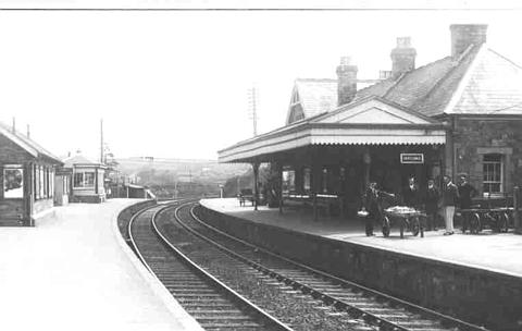
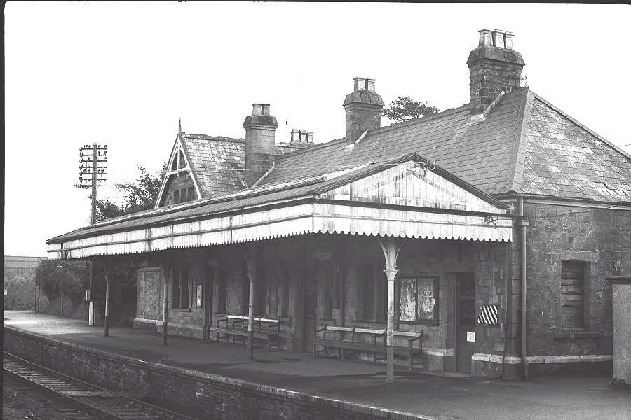
Bere Alston station circa-1930 looking east towards Tavistock
In 1874 the London & South Western Railway (L&SWR) opened an extension of their standard-gauge main line from Exeter via Okehampton to Lydford, where it met the single-line broad-gauge branch of the South Devon Railway (SDR) from Plymouth via Tavistock to Launceston. The L&SWR reached an agreement with the SDR, who granted running powers to the L&SWR and laid a third rail on their branch so that the L&SWR trains could run over the mixed-gauge line to reach Plymouth. The L&SWR line was built originally as a single-track also, but by the end of 1879 it had been doubled right through to Lydford.
The arrangement with the SDR was not ideal and the L&SWR service suffered from the need to run trains to and from their busy main line along a single-track branch owned by another company. However in 1890 the Plymouth, Devonport & South Western Junction Railway (PD&SWJR) opened a new double-track main line from Devonport (Plymouth) to Lydford, where it made an end-on connection with the L&SWR line. This new line was leased to the L&SWR, who now gained their own independent access to Plymouth. Unlike the SDR branch, which ran from the east of Plymouth, the PD&SWJR line ran from the west of Plymouth close to the River Tamar and Bere Alston station was situated on this section of line.
On the Cornish side of the River Tamar there were many mines and quarries in the area around Gunnislake and Callington. These were connected to the riverside quays at Calstock by means of the narrow-gauge East Cornwall Mineral Railway (ECMR), which had been opened in 1872 from Callington to Calstock. In 1891 the PD&SWJR purchased the ECMR and in 1908 they opened an eastwards extension to join their main line at Bere Alston. The whole of the branch was converted to standard gauge and upgraded to carry passenger traffic as a Light Railway. The extension was known officially as the "Bere Alston & Calstock Light Railway", but often it was referred to simply as the "Calstock Light Railway" and this term seems to have been used for the whole of the branch to Callington. Click here for more details about the Callington Branch.
Bere Alston station was opened for passenger traffic on 2nd June 1890 as part of the new PD&SWJR line from Lydford to Devonport, although the goods yard and signal-box had been in use since 12th May that year. At first the station was named 'Beer Alston', but the spelling was changed to 'Bere Alston' in November 1897. It was a fairly ordinary station with separate Up and Down platforms on the double-track line - the line being regarded as 'Up' to Exeter and 'Down' to Plymouth. The next station up the line was Tavistock, whilst down the line was Bere Ferrers. Although the PD&SWJR line ran generally from south to north on its way from Plymouth to Lydford, the curvature of the line as it followed the high ground east of the Tamar meant that Bere Alston station in fact lay on an east-west axis (east being at the Tavistock end). The line was on a continuous curve of 20 chains right through the station, falling at 1 in 330 towards Tavistock. The mid-point of the station was 220 miles 15 chains from Waterloo station (the L&SWR terminus in London).
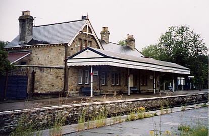
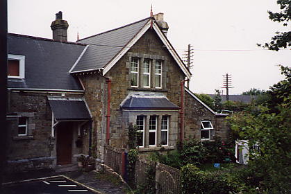
The main station buildings were situated on the Down platform and these were a smaller version of the style provided at Tavistock. There was a waiting shelter on the Up platform and a wooden footbridge between the two platforms at the Plymouth end. At the rear of the Up platform there was a goods shed, end-loading dock and two sidings, which were connected to the Up line by a trailing connection at the Tavistock end. There were crossover roads between the Up and Down lines at both the east and west ends of the station. The signalling of the station was controlled by a 17-lever L&SWR Type 3B signal-box, which was located on the Up platform near the Tavistock end. All the main buildings were constructed of local Dartmoor granite with slate roofs.
In 1908 Bere Alston became a junction station with the opening of the extension of the "Calstock Light Railway", although the actual changes appear to have been fairly minimal. The new branch approached the station from the north-west on a sharp curve and steep rising gradient, and ran into the goods yard area at the rear of the Up platform. The Up platform now became an island platform, with a new rear face 240' long along the western part of its length to serve the branch trains - at the eastern end of the branch platform was the zero point for calculation of mileages on the branch. Apart from the addition of a run-round loop and two further sidings next to the branch, there appear to have been no further alterations to the original layout.
The track plan below shows the arrangements at the station circa-1920 (although unfortunately the plan omits the crossover just west of the branch platform which connected the branch line into the adjacent run-round loop ). The gradient of the branch at the approach to the station was so steep (at 1 in 40) that the buffer-stops at the ends of the new sidings adjacent to the branch (of which the first part can be seen on the plan) were almost at the roof height of trains on the branch line!
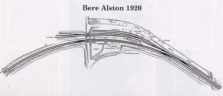
The branch was provided with its own signal-box, which was situated at the Calstock end of the island (Up) platform next to the road underbridge. This signal-box was a small ground-level wooden hut, of the same style as provided elsewhere at that time on the new branch, and it contained a 4-lever interlocking frame. The branch signalling was very basic, in keeping with its Light Railway status, with just Home and Starting signals. (Click here for more details on the signalling of the Callington Branch.) The only physical link between the new branch and the original PD&SWJR line was a single connection within the goods sidings - this was controlled by an adjacent single-lever ground-frame, locked by a key kept in the main-line signal-box.
After the Railway Grouping of 1923 the new Southern Railway (SR) took over the L&SWR and PD&SWJR lines, and became the new owners of Bere Alston station. In 1927 they closed the former branch signal-box and transferred its work to the ex-L&SWR box. This signal-box was extended at the Plymouth end and the lever-frame was increased from 17 to 30 levers in order to accommodate the additional signals that were added to the 'branch' side of the station at the same time. The signalling details for the new layout can be seen in a later signal diagram circa-1961. Also during SR ownership the original wooden footbridge between the main-line platforms was replaced by one comprising a lattice-girder span with concrete supports pillars and steps. The platforms themselves were each about 420' long on their main-line faces.
 |
 |
Nationalisation and Later Changes
After railway nationalisation in 1948 Bere Alston was controlled variously by the Southern and Western Regions of British Railways, as different boundary changes took effect. During the early 1960s the freight traffic declined and steam gave way to diesel multiple units (DMUs) for the passenger service on the branch. There was talk of total closure of the branch, but the poor road access in the area meant that the railway viaduct at Calstock remained an important link across the River Tamar. However on 5th November 1966 the Callington Branch was closed completely beyond Gunnislake and the remaining section stayed open for passenger traffic only. The same year saw the closure on 2nd August of the two sidings (opened in 1908) adjacent to the branch.
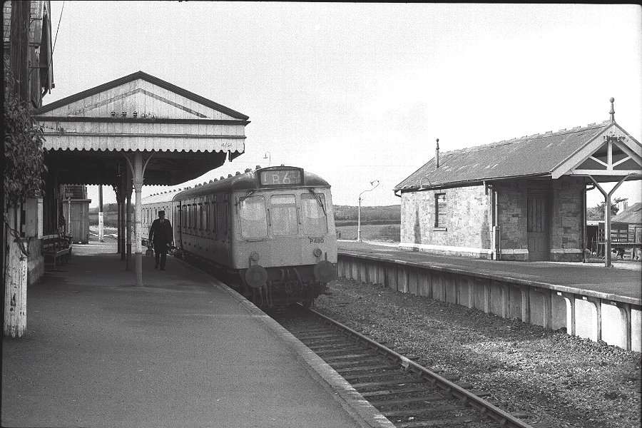
On the 6th May 1968 the whole of the ex-L&SWR main line from the east end of Bere Alston station (at mileage 219m 66c) to Meldon Quarry (just west of Okehampton) was closed completely to all traffic. This radical reduction in the railway service in West Devon left Bere Alston as the terminus of a double-track branch from Plymouth over the truncated remains of the former PD&SWJR line, served only by local trains. However it continued to function as a through station rather than a terminus, because the passenger service was revised so that all trains ran through from Plymouth to Gunnislake with a reversal at Bere Alston.
With the disappearance of freight traffic all the remaining sidings at Bere Alston were abolished in November 1968 and subsequently removed, along with the branch run-round loop, leaving only a plain single-line on the branch side of the Up platform. The branch now made a simple trailing connection direct with the former Up Main, but the directions were re-named so that the line was now 'up' to Plymouth rather than 'down'. The new arrangements can be seen in the revised 1968 signal diagram. Down DMUs from Plymouth arrived at Bere Alston and stopped at the former Up platform, then pulled forward and reversed onto the branch. In the return direction the DMU ran off the branch onto the old Up main, then reversed across the eastern crossover onto the old Down main and ran back to Plymouth. It was not uncommon for the train to stop at both the main and branch platforms, so a 'free' trip across the station by train was always a possibility!
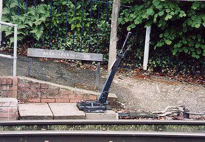
On 7th September 1970 Bere Alston signal-box was closed and the main line to Plymouth was reduced to a single track serving the former Down platform, which is now the only one in use. The branch was re-aligned to make a new junction at the south end of the former Down platform and the old alignment past the rear of the island platform was abandoned. The new junction is controlled by a 2-lever ground-frame, which is released by a key on the single-line train staff and worked by the guard. After this re-arrangement the island platform was taken out of use and the footbridge demolished.
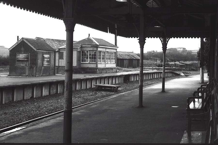
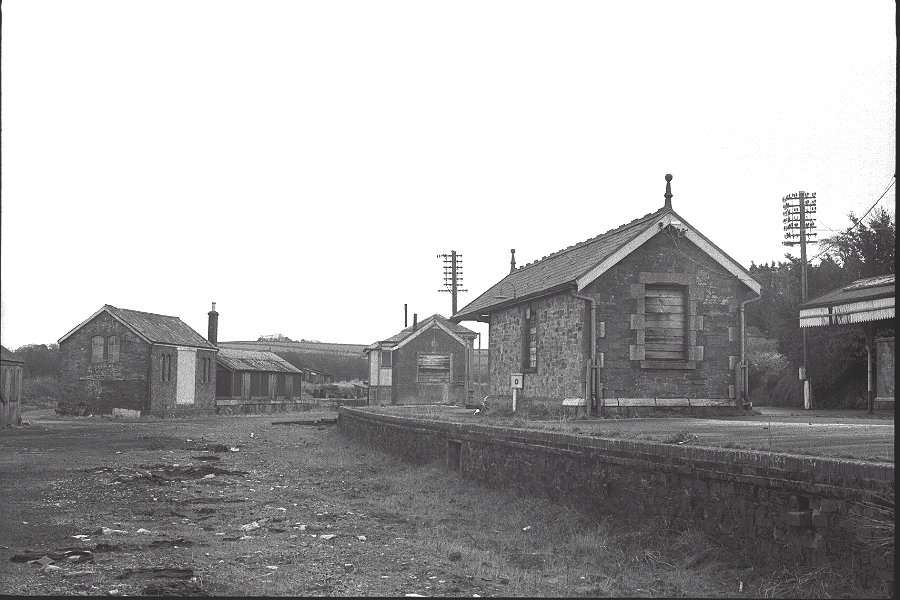
During the 1970s and early 1980s Bere Alston station suffered from the neglect that afflicted so many rural railways. All the railway staff were withdrawn and the station was boarded-up, although the former station-master's house remained in use as a private dwelling. The following set of photographs from the early 1970s gives an idea of the general air of dereliction which existed at that time (click on the thumbnail images to see larger pictures).
| Bere Alston station photographed in the 1970s | ||||||||
 |
 |
 |
 |
 |
||||
| Station building on old Down platform |
Looking across to former Up platform |
Looking west towards Plymouth |
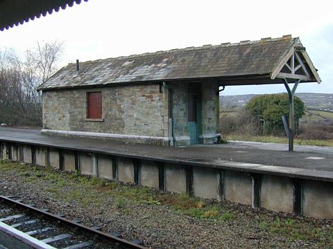
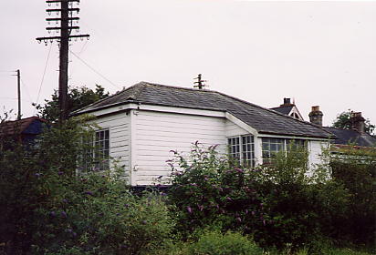
Disused branch side of Up platform |
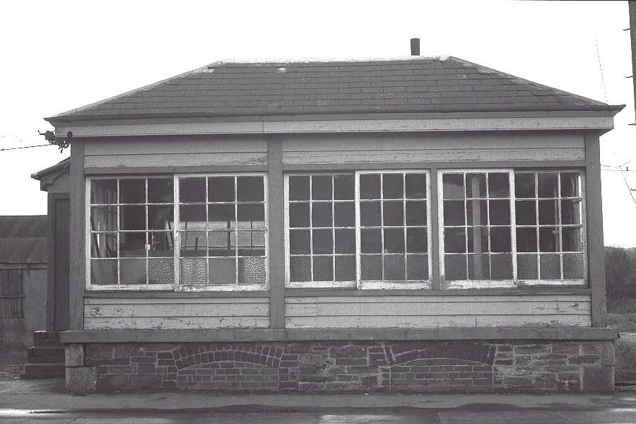
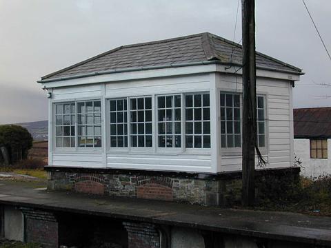
Former LSWR signal-box |
||||
In due course new British Rail 'corporate image' signs and paint appeared, but they soon faded and the station slowly rotted and rusted away. However fortunately British Rail eventually woke up to the potential of the line and began marketing it as the "Tamar Valley Line", promoting its scenic views and tourist attractions. As a result the station eventually received a much-needed visit by the painters, who applied a colourful livery to the wood and iron work of the station building and platform which made a great improvement. Both the former signal-box and the waiting shelter survive for use by the Engineers' Department and indeed the signal-box was refurbished in recent years. Sadly however the former goods yard remains an area of dereliction. The Photo Gallery has some pictures of the station in recent times.

In 2007 this enamel sign (measuring 16' x 18") was discovered in Bere Alston, but its origin was a mystery for a number of reasons. Firstly, although Bere Alston did become a junction with the opening of the branch to Callington, there is no record that it was ever officially known as 'BERE ALSTON JUNCTION'. The colour scheme (white lettering on a dark blue background) is also confusing as it does not conform to the known colour schemes of either the L&SWR or PD&SWJR. Although a number of the signs on the station have appeared in photographs over the years, there was nothing known to match this one.
A photograph from the L&SWR period shows the running-in board on the Down platform and that read:- 'BERE ALSTON CHANGE FOR THE CALLINGTON BRANCH'. This board had dark lettering on a light background - the colour scheme is subject to debate but there seems to have been a degree of regional autonomy with the light colour described as white, cream and salmon and the dark colour described as black, brown and stone. Later photographs show the signs as white lettering on a dark background (white on green) and confirm that the running-in boards that faced the main line on both the Up and Down platforms were worded the same - originally the L&SWR boards repainted, later they were replaced by enamel signs. The board on the Up platform was double-sided, but the branch side said simply 'BERE ALSTON'.
However a photograph circa-1910 shows a long rectangular plate on the rear wall of the waiting shelter on the island Up platform. Although impossible to read the wording, further investigation has shown that it would have matched the size of the mystery blue sign. The origin and/or style of this sign may in fact lie with Colonel H F Stephens, from his involvement with the re-building of the ECMR. From comparison with other railways in his 'empire' he was very fond of enamel signs with white letters on a blue background, and he also used the term 'Junction' whenever he created a 'joint station'. When the branch was built to Bere Alston there are signs of Col Stephens separating 'his' facilities on the station from those of the L&SWR - this was his standard practice so that he didn't pay rent to the larger company for their facilities if he could provide them himself. Although not firm proof, it would seem likely therefore that this mystery blue sign was provided by Col Stephens in order to face 'his' railway.
© Chris Osment 2003
Track plan courtesy of George Reeve (Irwell Press)
1930 photograph courtesy of Mike Watts collection, 1970s photographs
courtesy of Steve Johnson
Blue sign image and information courtesy of Bruce Hunt, with further
information courtesy Brian Janes (The
Colonel Stephens Museum)
Photo Gallery (Click on the thumbnail images to see larger pictures)
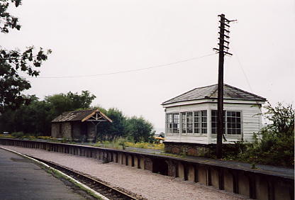
| Bere Alston station photographed on 26th December 2001 | ||||||||
 |
 |
 |
 |
 |
||||
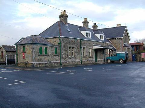
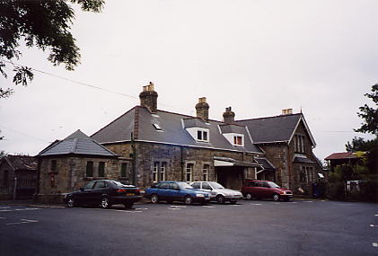
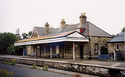
| Station building seen from forecourt |
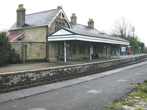
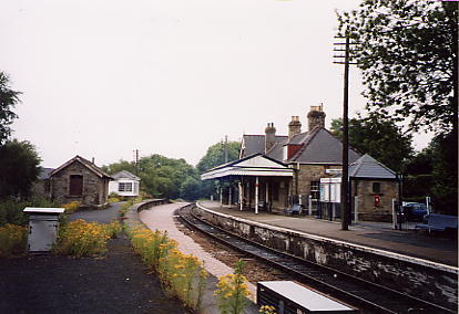
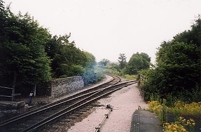
Looking west towards Plymouth |
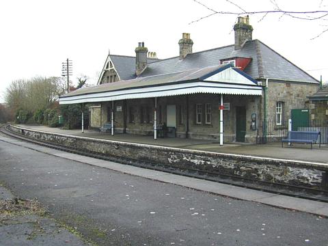
Looking east towards Tavistock |
Disused shelter on island Up platform |
Former ex-LSWR signal-box |
||||
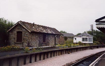
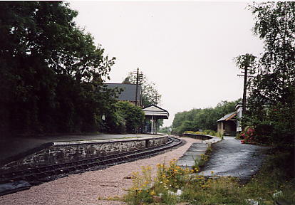
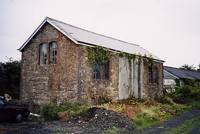
Bere Alston station photographed on 8th July 2003 |
||||||||
 |
 |
 |
 |
 |
||||
| Station building seen from forecourt |
Looking west towards Plymouth |
Looking east towards Tavistock |
Rear of disused shelter |
Rear of signal-box |
||||
 |
 |
 |
 |
 |
||||
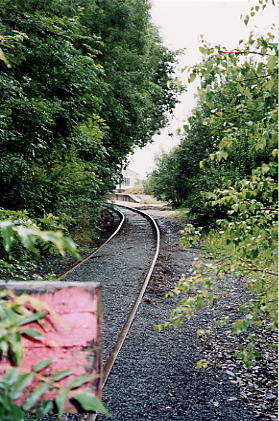
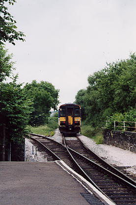
| Looking east towards Tavistock |
Looking east towards Tavistock |
Looking west towards Plymouth |
Looking west towards Plymouth |
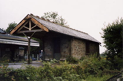
Disused goods shed | ||||
 |
 |
 |
 |
 |
||||
| View from the dead-end |
Station house | Ground frame | Junction looking towards Plymouth |
Train leaving for Gunnislake |
||||
2001 photographs © Mike Dunse 2003 photographs © Chris Osment
|
© West Country Railway Archives 2003 Page last updated: 02 Mar 2012 |
Home Page: http://www.railwest.org.uk E-Mail: railwest@bigfoot.com |
||||||


