


INDUSTRIAL, TERMINAL RAILROADS & RAIL-MARINE OPERATIONS OF BROOKLYN, QUEENS, STATEN ISLAND, BRONX & MANHATTAN:
 |
 |
 |
| PALMER'S
DOCK EAST RIVER TERMINAL RAILROAD and the BROOKLYN EASTERN DISTRICT TERMINAL |
||
|
A Comprehensive History of Operations, Property, Equipment and Personnel 1870 - 1983 |
||
by Philip M. Goldstein © 2025 |
||


|
updated:
|
||
|
update summary: |
date: | website location: (with quicklink) |
| Brooklyn North "Red Survey" Maps 14 & 15 (North 3rd through North 12th Streets) added Pidgeon Street - Queens "Red Survey" Map 21 (Pidgeon street) added Queensboro Terminal - Queens "Red Survey" Map 25 added 1967 oblique aerial images of direct carfloat service to Domino Sugar Refinery added 1967 oblique aerial image of Schaefer Brewery (centerpipe carfloat) added 1912 North 9th Street Grain elevator photo added 1965 oblique aerial of North 10 - 12th Street property image added |
24 July 2026 | Brooklyn North Waterfront "Red Survey" Maps 14 & 15 Queens Waterfront "Red Survey" Map 21 Queensboro Terminal Kent Avenue South 3rd Street - Domino Sugar Breweries - Schaefer Brewery Property images Independent Scrap - Property Image N 10 the Street |
counter activated
12/6/2021
MAIN
INDEX
(with subchapter listing)
|
A
substantial amount of documents, newspaper articles, large images,
technical drawings, maps and graphics were placed on their own
"subpage" to better utilize space on this
main page.
* = .pdf file with no return link to this page: right click and open file in new window or use back arrow on your web browser to return to this website! |
||||||||||||||||||||||||||||||||||||||||||||||||||||||||||||
This website, while theoretically is stand alone, is in fact only just one part of another more comprehensive website which pertains to the extensive freight railroad history in the New York Metropolitan Area:
In conjunction with that above research, I have also yet another website detailing the histories of military installations with accompanying rosters of locomotives that operated throughout the New York Metropolitan Area:
MILITARY RAILROADS OF THE NEW YORK METROPOLITAN AREA
This link is to the main index to all my websites, almost all of which are concerned with the history of various things in the New York City area, not solely pertaining to railroads:
INDEX OF WEBSITES BY PHILIP M. GOLDSTEIN
.
.
.
.
|
|
|
Welcome! You have found the most comprehensive and authoritative website on the world wide web regarding the facilities & operations known as Palmer's Dock, East River Terminal Railroad and the Brooklyn Eastern District Terminal. As information continues to be located, submitted and obtained on an in-frequent basis, I strongly recommend that you bookmark this website and check back frequently, as this website is updated as that information arrives. To think that this website originally started out in 2005 as a mere roster and photo album for only the steam locomotives; yet has progressed into the comprehensive and detailed history of the people, the properties and all the equipment that eventually went on to be known as the Brooklyn Eastern District Terminal. This historical accounting has even exceeded my expectations, and is only made possible with the assistance of many fine and established historians and BEDT fans including: Robert Brendel, Jose Feliciano,Thomas Flagg, Tom Hendrickson, Joseph Roborecky, Paul Strubeck and Jay Wanczyk. It is only fair they receive credit for their contributions. This website is as much theirs as it is mine and everyone who has contributed to this website appears in the special thanks chapter in alphabetical order. Not forgetting what I set out to do, I am also proud to acknowledge that this website also contains the largest photo archives of Brooklyn Eastern District Terminal you are ever likely to see on the web or in any bound book. The collection of images on this website, contains the images from several notable "old time" collections; F. Rodney Dirkes, Harold Fagerberg, Gerald Landau, Steve Meyer and Frank Zahn to name a few. It is also due to the unprecedented and selfless cooperation of many other renowned photographers, (as well the current owners of those photo archives), such as: Art Bink, Seth Bramson, Gene Collora, Tim Darnell, Al Galanty, Theodore Gleichmann, David Keller, Norman & Marie Wright, Ron Ziel and many others. They made their generous contributions to this website in good will and for the entire railroading community to share, in admiration of this Fallen Flag Railroad. Our gratitude is also due to the repositories of many digital collections and archives for both images and documents, including but certainly not limited to: New York Public Library, New York State Library, Railroad Museum of Pennsylvania, Southern Methodist University Library / DeGolyer Collection, Hagley Museum & Library, University of Pittsburgh, and the Canada Science & Technology Museum. Therefore, I ask that you please respect the ownership copyrights on those said images where listed. Other than that, please enjoy the website and don't forget to sign the guestbook!
~
Philip M. Goldstein ~ |
A
Brief History Of Rail - Marine Traffic in
New York
.
..
|
Map
of Railroad & Terminal Facilities in the |
|
A Glimpse of the Way Things
Were
It is the year 1870. Ulysses S. Grant is in the White House after being elected president following a successful victory in the Civil War. Walrus mustaches are popular among men, and tops hats are in. The Department of Justice is created as a government agency. The Army Weather Bureau is created, and this would become the National Weather Service and the current Cape Hatteras Lighthouse is placed in service. The transcontinental railroad celebrates it's 1 year anniversary. There are no electric lights and either the mail or the telegraph is the means of communicating long distance, (even though a gentleman inventor named Alexander Graham Bell is tinkering with acoustic telegraphy, which in a a few years yields a device that will eventually become known as the telephone).
In New York City; the Statue of Liberty does not exist and just north, Ellis Island, known then as Castle Garden, is beginning to bustle with freshly arrived immigrants looking to become Americans. North Manhattan is wild forests. Staten Island is similar with a smattering of farms. Brooklyn and Queens are highly developed the closer you get to New York Harbor, but the eastern edges of Brooklyn & Queens are what would be considered "rural", and farmland dominated the view.
Long distance travel, primarily via horse drawn wagon; is beginning to give way to the railroads. But, horse drawn carriages and small steam locomotive drawn street cars were the way to travel anywhere out of walking distance within the city.
Long Island (which is comprised of Kings [Brooklyn], Queens, Nassau & Suffolk Counties), and Staten Island (Richmond County) were truly isolated from the mainland US. There are no bridges or tunnels spanning the East or Hudson Rivers. The Brooklyn Bridge would not be opened until 1883 and the Manhattan, Williamsburg, Queensboro or George Washington Bridges would not be built until may years after that. There are no Holland, Lincoln or Queens Midtown Tunnels.
The only way to transport anything to these locations was by water: either by ship, boat, lighter or barge. If you found it necessary to go from Brooklyn or Queens to Manhattan, or from Staten Island or New Jersey to Manhattan, you would have to take a ferry. The waterborne vessels of this period are powered either by wind and sail or primitive steam power and coal is starting to increase as the fuel of choice for furnaces and boilers, which are used for heat or propulsion power.
The "second" industrial revolution is underway in earnest, and the mass production of consumer goods is taking hold. To get the raw materials, commodities and items from the mainland to Long Island, everything was shipped by water from New Jersey to Manhattan and Long Island. Today, it is difficult to envision this isolation with the myriad of bridges, highways, and tunnels (and gridlock!) linking Brooklyn, Queens and Long Island with the mainland.
As a result of this waterborne traffic, many dockside terminals and warehouses were built around the New York City proper for storage. The large mainland trunk line (or known later on as Class 1) railroads had their own equipment and properties; namely: tugboats, lighters, barges and ferries to bring these commodities to and from various mainland railroad points around the NY Harbor. To get the commodities to the New Jersey shoreline; many railroads, their locomotives themselves powered by steam, have built a vast network of tracks radiating towards the New York area.
In the pre-float bridge days, freight had to be manually transferred at the docks and wharves from newly arrived trains to barges and lighters (a lighter is essentially a barge with an enclosed structure on it, similar in design to a one room warehouse). Of the lighters that carried products that need to be kept chilled, (i.e.: milk, meat, fruits and vegetables), these lighters were insulated (usually with double walls filled with sawdust) and were equipped with roof hatches for the loading of ice to be carried on board.
This was a time consuming and back breaking method, of having to unload a freight car on the dock, load it onto a lighter or barge, transport the lighter cross-harbor to Brooklyn, then unload it. Then repeat the process again for the trip back. It also required vast labor pools. There had to be a better way...
The Development
of Carfloats & Float bridges
(or how to get freight cars from here to there by water)
.
So in order to load and unload the railcars themselves from the carfloats, the carfloats would be moored to the device known as the float bridge and that's where the pontoon type float bridge came in. But, the actual design of the local float bridge had to be figured out at that point.
This dilemma had been solved by the invention and development of the carfloating and the "float bridge" or "transfer bridge". The history of the the first railroad car transfer bridge in the United States, reflects that it was built in 1838 under a joint venture by the Camden & Amboy and Baltimore & Potomac Railroads to provide passenger car ferry service across the Susquehanna River at Harve De Grace and Perryville, Maryland.
Understanding the
Differences between "Carferrying" and
"Carfloating"
It should be understood that the primary difference between carferrying and carfloating is thus:
Carferrying
essentially was a way to take entire trains (freight
or
passenger) across a body of water and usually the entire train
in a single trip; at a location where for various
reasons a bridge or tunnel would have been impractical.
Once this train
has been ferried from one shore to the other, it
would continue on its journey to its final destination, which
may be hundreds of more miles from the ferrying point. Of
course, when a bridge could be built over (or a tunnel under) that
waterway at a later date, it would be; thereby greatly reducing those
delays in those trains having to use car ferry transportation.
Based on this, carferries were almost always self-propelled and large
enough to accomodate a large train.
Carfloating
on the other hand,
at least in regard to New York Area operations,
started primarily as an extension to a terminal operation; dedicated
specifically for freight service (no passanger conveyance), which is
quite different from carferrying.
Of course, carfloating was used where building a bridge was impractical
as well.
This became especially so, as freight traffic grew and destinations all
around the harbor were added to the terminal. Many bridges would be
needed to span the Hudson, East & Harlem Rivers and since the
bridges and their associated approaches would need to be built tall
enough as not to impede the marine traffic, a great deal of very
valuable real estate would be wasted on the shores of New York
Harbor and connecting estuaries!
Carfloats however,
could
be brought to anywhere along the hundreds of miles of waterfront in the
region, over tax-free "real estate" maintained by the government, i.e:
the harbor waters. They could be moored to a simple pier anywhere along
the waterfront, and loaded and unloaded without any sort of supporting
infrastructure.
Most
importantly, the end destination of the carfloat was a freight terminal
or pier. The train (or freight cars) did not continue onwards from that
destination.
Furthermore, carfloats are unpowered, and need a tugboat to move them
from one location to another.
.
 |
The first intensive use
of the dedicated carfloating of freight in the United States seems to
have occurred during the Civil War, when freight cars were floated on
makeshift barges along the Potomac River, to serve places where
existing rail lines could not reach for various reasons. As
published in "American Railroad Freight Car", by John H. White, Jr.
(1993, Johns Hopkins University Press) credits Brigadier
General Herman Haupt for first carfloating on a barge in 1862, during
the Civil War. In the October 2000 issue of "Model Railroader"
magazine, p. 82-85 there is an illustrated article on the
November 1862 construction, under the direction of Brigadier General
Herman Haupt, of a carfloat operation for the Union Army at Alexandria,
Virginia.
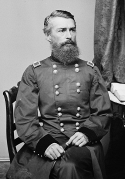
Haupt had been the Chief Engineer of the Pennsylvania Railroad and was in the process of constructing the Hoosac Tunnel when he was "conscripted" to run the U. S. Military Railroad. Two steam powered tugboat drawn floats were constructed, each holding 8 cars transversely, and they were served by triple-track aprons at the transfer landings, running from Alexandria, Virginia, down the Potomac River 60 miles to Aquia Landing, about 10 miles northeast of Fredericksburg, Maryland. In addition, George Abdill on page 48 of his book "Civil War Railroads: A Pictorial Story of the War between the States, 1861-1865 "(1961, Indiana University Press) calls it "pioneer car ferry" which it was not. Instead, it was the pioneer carfloat in the United States. General Haupt supervised the construction of these transfer bridges at both terminals of this proposed water route. General Haupt also designed, requisitioned materials and built the unique railroad float barges. The carfloats consisted of two large-sized Schuylkill type barges moored side by side, across both of which long timbers were placed supporting eight tracks mounted transversely (from port to starboard instead of the modern configuration of bow to stern). At Alexandria, VA; the loaded freight cars were placed singly aboard each of the eight tracks of the carfloat. The carfloat was then towed sixty miles by steam tug to Aquia Landing, VA. Once at this location, railroad crews unloaded the carfloats by pulling the cars. While not this has not been confirmed, it appears from maps and background detail that the three transfer bridges were located in Alexandria, VA; and the eight track bulkhead was at Aquia Landing, VA. We were able to locate three images of the operation in searching the web. All three images are attributed to the National Archives, but were located on a very nice website showcasing Bernard Kempinski's "The American Civil War in Miniature". |
|
|
Brigadier
General Herman Haupt |
||
|
|
|
|
| . | ||
|
|
||
|
The wharfs and transfer bridges at Alexandria, Virginia. All
four photos: |
||
.
Once the freight cars were unloaded, they were then able to forward those freight cars with their contents, without the need of "breaking bulk" (unloading the freight from the car) along the rebuilt rail line of the Richmond, Fredericksburg and Potomac Railroad to Falmouth, across from Fredericksburg, VA; on the north bank of the Rappahannock River.
According to Haupt this was:
"the first known attempt to transport cars by water with their cargoes unbroken. The Schuylkill barges performed admirably and thus was formed a new era in military railroad transportation. The length of the barges were sufficient for 8 tracks carrying eight cars, and two such floats would carry the sixteen cars which constituted a train."
All of this construction occurred over a period of two weeks. Haupt was ready to support further military operations by November 17th, 1862. As to how the cars were loaded onto the barges, the technology was already in place for carferrying. So the Civil War usage of carfloating maybe was more of an inspiration than an invention, inspiring the New Jersey railroads about how to serve Manhattan without having to unload everything out of the cars onto ferryboats or sail lighters on the Jersey side.
.
Carfloating comes to New
York Harbor
.
The first mention of carfloating in New York Harbor can be read in the (Trenton) Daily State Gazette, November 13, 1866, p. 3:
"CENTRAL RAILROAD: The Central Railroad Company [of New Jersey] are having a large scow constructed for the purpose of conveying the freighter cars directly from Communipaw to the New York side. It is large enough to hold eight cars which will be run in on rails from the track on this side. It will be in operation next week. The Western mail which has heretofore been carried by the Erie Railway has been transferred to the Central Road."
As to this and the early history of carfloating in general, why do we call this only a "hint" ? While this article does state fact, it turns out that there were forces behind this operation that were more complex than mentioned here. Believe it or not, the Pennsylvania Railroad was the real sponsor, even though at the time its own tracks came nowhere near New York Harbor!
As read in "History of the Pennsylvania Railroad", by J. Elfreth Watkins, 1896; the Empire Transportation Company's line was organized in 1866, it wished to deliver to Manhattan and since the Pennsylvania Railroad did not reach or have a terminal at that location, it contracted with the Central Railroad of New Jersey, which did build the first carfloat for that purpose. Early in 1867, the operation began with the first carfloats carrying those freight cars across the Hudson River. The "car-ferry" route was from Communipaw, NJ Terminal to Pier 14, on Manhattan's west side, which was occupied at the time by the Central Railroad of New Jersey.
By this method, the Empire Transportation Company was able to load & unload its freight cars at Pier 14 in New York City and transport said freight to its destinations without the need to "break bulk". Arrangements were then made by the Union Railroad and Transportation Company with the Camden & Amboy Railroad and the New Jersey Railroad & Transportation Company for hauling these freight cars through Jersey City, instead of unloading the freight in New Jersey, and transporting it via steamboat between South Amboy and Pier 2 in Manhattan, which had been the existing procedure.
As the remainder of the railroads in New York Harbor saw the advantages of carfloating, it rapidly gained acceptance and use. Lighters by the way, weren't totally obsolete; as some railroads still maintained "pier stations" along the waterfronts, where there was insufficient room for a rail terminal and float bridge.
Lowell Palmer also recognized the usefulness of carfloating, and as discussed later on this website, he would install his first float bridge on the Williamsburg waterfront in 1876. According to research, this would be the very first float bridge constructed for use by a Brooklyn rail terminal; and in all likelihood, the first float bridge for a rail terminal anywhere east of the Hudson River.
Should you be interested in an in-depth comprehensive look at the development, designs and histories of carfloat transfer / float bridges in the New York Harbor area, please refer to this page of the website: Development of Carfloat Transfer Bridges in New York Harbor.
If
you
would like to learn how carfloats
were "moored" to the float bridges, and the proper procedure for such,
please
visit the following chapter through this link:
Carfloat
Mooring & Pinning Procedures.
Railroads on the Shores
of New York Harbor
There were dozens of railroads that took up residence on the Hudson River shoreline, some with more than one railyard. Many of those railroads would merge with another throughout their history, and henceforth bring about a name change, but for historical purposes I will name each railroad as an individual, as this website applies to the cumulative history since 1870. A list of those railroads, throughout the history of New York Marine Rail operations, are as follows:
|
. |
 |
..
1943 Terminal &
Facilities Map for the Port of New York
.
Mere words cannot show the prevalence of the mainline railroads on the shores of the Hudson River, so I have included a excerpt from a 1943 Terminal & Facilities Map for the Port of New York, issued by the New York Central Railroad. You can view a large image by clicking on the thumbnail:
|
|
Throughout those ensuing years however; while almost all these railroads would have some sort of facility on the the west bank of the mighty Hudson River (also referred to as the North River), those shipments from New Jersey that were destined for Brooklyn, Queens and Long Island; meant going through the four Brooklyn and one Queens terminals.
Only a small handful of the trunk line / class 1 railroads had terminals in Brooklyn and Queens that were equipped with float bridges for carfloating operations, those being:
|
terminal |
location |
railroad |
|
Brooklyn Brooklyn Brooklyn Brooklyn Brooklyn Queens |
Pennsylvania RR Baltimore & Ohio / New York New Haven & Hartford RR Long Island RR / New York New Haven & Hartford RR Delaware, Lackawanna & Western RR Delaware, Lackawanna & Western RR Long Island RR / Pennsylvania RR |
*Footnote:
the Pennsylvania yard at North
4th Street was surrounded by BEDT and yet had no physical
connection
to the BEDT tracks that surrounded it, as was the BEDT Pidgeon Street
yard
was across the street from the LIRR yard, but again there would be no
track
connection between the
two. The
only interchange
connections between these railroad terminals was by carfloat.
Independent / Contract
Terminals of Brooklyn
.
In addition to the large trunk line or "class 1" railroads carfloating to and from Manhattan and New Jersey, there were also the "independent" or "contract" terminals located in Brooklyn. These were known as "contract terminals", as they would be contracted by the trunk line / class 1 railroads to deliver the freight cars to their final destinations in Brooklyn and Queens, which of course in most cases those trunk line / class 1 railroads could not do.
These terminals, such as the Brooklyn Dock & Terminal and Brooklyn Wharf & Warehouse would be eventually absorbed by the larger terminals and after they were absorbed, history may have forgotten their names until now. These contract terminals would prosper, expand, and some would eventually utilize steam, diesel & electric locomotives for the unloading and loading of rail traffic transported by barge, lighter and carfloat.
The recognized "independent" or "contract" (non-class 1) terminals with railroads in Brooklyn were:
|
.
It should also be understood that Palmer's Dock / East River Terminal Railroad / Brooklyn Eastern District Terminal, New York Dock, Bush Terminal and Jay Street Connecting offline terminals were known collectively as the "Union Freight Terminals". This was due to the fact that the Brooklyn Eastern District Terminal, Bush Terminal and New York Dock all handled freight for many of the Class 1 railroads. This is in contrast to the Class 1 owned offline terminals, where almost all of the freight handled was consigned to that sole specific railroad.
Palmer's Dock would be organized this year, 1870; and thus is the reason this year is the starting point for our journey through history above. Palmer's Dock, and through it's successors: the East River Terminal and the Brooklyn Eastern District Terminal, operated until 1983 and at it's peak, would have a total capacity of 1000+ cars, would transport 27,000 cars per year and the distinction of serving the New York "Brooklyn" Navy Yard.
Palmer's Dock / East River Terminal Railroad
/ Brooklyn Eastern District Terminal had many float bridges
throughout
its history, which were located at:
.
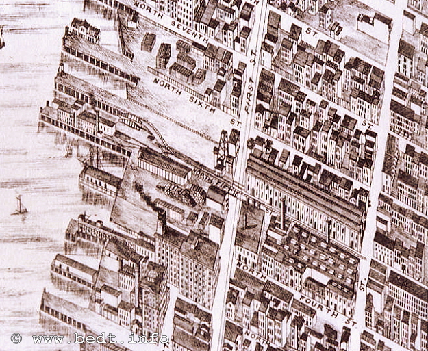
| North 3 Street | Williamsburg, Brooklyn |
| North 5 Street | Williamsburg, Brooklyn |
| North 6 Street | Williamsburg, Brooklyn |
| North 9 Street | Williamsburg, Brooklyn |
| Wallabout Terminal | Wallabout Basin, Brooklyn |
| Brooklyn Navy Yard | Wallabout Basin, Brooklyn |
| Pidgeon Street | Long Island City, Queens |
| Warren Street | Jersey City, NJ |
|
as well as pier stations, which were located at: |
|
| 13th Street "Queensboro Terminal" | Long Island City, Queens |
| South 3 Street | Williamsburg, Brooklyn |
I
myself, am
particularly interested in
the history of the Palmer's Dock / East River Terminal Railroad /
Brooklyn
Eastern District Terminal; and this website reflects that interest. Now
that
we can understand of the mechanics of carfloating and the importance of
the
contract terminal in Brooklyn, we will now delve into the intricate and
detailed
history of the Palmer's Dock / East River Terminal / Brooklyn Eastern
District
Terminal.
.
.
Timeline of Palmer's Dock, East
River Terminal
Railroad & Brooklyn Eastern District Terminal
.
..
.
..
Significant Dates
In Palmers Dock / East River Terminal / Brooklyn Eastern District
Terminal
History
I felt it was important for the reader to comprehend the significant dates in Palmer's Dock, East River Terminal and Brooklyn Eastern District Terminal history.
Therefore, this chapter outlines those significant dates, in chronological order.
| 1870: | Palmer's Dock wharf facilities organized |
| 1873: | First carfloat & tugboat purchased by Lowell Palmer, and Erie RR is sole interchange customer / partner |
| 1874: | Palmer's
Dock railyard construction begins Palmer's Dock establishes and leases a terminal to Erie Railroad Partnership with Havemeyer & Elder begins |
| 1875: | First
steam locomotive purchased Palmer's Dock begins interchange with NYC, WS, CRRNJ, DL&W & PRR railroads |
| 1876: | First float bridge installed along Kent Avenue in Williamsburg, Brooklyn |
| 1905: | Lowell Palmer disassociates from Palmer's Dock operations |
| 1906: | Palmer's Dock properties is incorporated by Havemeyer's & Elder into Brooklyn Eastern District Terminal (navigation corp.) |
| 1906: | Pidgeon Street Terminal, Long Island City opens |
| 1907: | East River Terminal Railroad incorporated by Havemeyer's & Elder |
| 1910: | Warren Street Terminal, Jersey City opens |
| 1914: | Queensboro Terminal (pier station), Long Island City opens |
| 1915: | ERT (railroad) & BEDT (navigation) consolidated and re-incorporated as BEDT (a consolidated "freight terminal" corp.) |
| 1928? | Warren Street Terminal, Jersey City closes |
| 1936: | Wallabout Market Terminal, Brooklyn opens |
| 1940: | (Possibly 1941) Operations begin in New York Navy Yard, Brooklyn |
| 1941: | Wallabout Market Terminal, Brooklyn closed due to expansion of New York Navy Yard, Brooklyn |
| 1962: | First diesel-electric locomotive purchased |
| 1963: | Steam locomotive operations cease |
| 1964: | Bulk Flour Terminal opens |
| 1966: | US Government sells Brooklyn Navy Yard to NY City for private development (operations continue) |
| 1967?: | North 5 Street float bridge use discontinued (possibly North 3rd Street as well) |
| 1972: | BEDT purchased by Petro Oil / Burmah Oil |
| 1976? | Petro / Burmah Oil (and BEDT) purchased by R. J. Reynolds Tobacco and merged with Aminoil |
| 1976: | BEDT receives contract from ConRail to carfloat for themselves & New York Dock |
| 1977: | (possibly 1978) Pidgeon Street Terminal, Long Island City closed |
| 1978: | Brooklyn Eastern District Terminal purchased by New York Dock |
| 1983: | Brooklyn Eastern District Terminal / New York Dock ceases all operations |
.
.
.
I have taken
the time to draw up a flow
chart, to better show the dates of incorporation and the principles
involved
with those corporations.
This chart was originally in two parts in the
Palmer's
Dock and Brooklyn Eastern District Terminal
chapters:
.
.
|
entity
/ corporation |
|
|
|
Palmer's
Dock's |
Lowell Palmer Lowell Palmer, |
|
|
|
||
|
|
||
|
Brooklyn
Eastern
District Terminal |
East
River Terminal Railroad |
Havemeyer & Elder |
|
|
||
|
|
||
|
Brooklyn Eastern
District
Terminal |
Havemeyer & Elder |
|
|
|
||
|
Brooklyn Eastern
District
Terminal |
Petro Oil Co. |
|
|
|
||
|
Brooklyn Eastern
District
Terminal |
.R. J. Reynolds / Aminoil Oil..... |
|
|
|
||
|
Brooklyn Eastern
District
Terminal |
New York Dock Properties |
|
| . | ||
|
for
more information, please refer to documents included in the ICC filing,
located elsewhere on this website: |
||
.
Palmer's Dock: 1870
-
1906
.
|
Lowell
Mason Palmer, for whom Palmer's Dock was named for; was a significant
manufacturer of barrels and casks in the New York area. These barrels
and casks were how large amounts of refined sugar, among many other
commodities, was shipped in those days.
Lowell Mason Palmer was born on March 11, 1845; in Chester, Ohio. Lowell was the oldest of two children from the marriage of Chester Palmer and Achsah Smith Melvin and could trace his roots on his mothers side to the Mayflower. Lowell Palmer was educated in public schools and attended Western Reserve College where he was a student until the outbreak of the Civil War. Upon the fall of Fort Sumter in 1861, and the call for 75,000 volunteers by President Lincoln, Lowell Palmer enlisted at the age of 16. He would fight in all the the battles of the Cumberland including: Chickamauga under General Thomas; in General Schofield's Corps in the Atlantic Campaign under General Sherman; and he participated in the battles of Franklin and Nashville. He became a member of General Schofield's staff, and would rise to the rank of Captain. |
|
Lowell Palmer would marry Grace Humphrey Foote on October 24, 1877. Together, they would have eight children:
| offspring | born | .. | died |
| Lowell Melvin | 1878 | ||
| Arthur Wellington | 1879 | ||
| Harold Irving | 1880 | 1889 | |
| Florence Edith | 1882 | ||
| Grace Marian | 1883 | ||
| Lily Cortelyou | 1885 | ||
| Ethel Josephine | 1889 | ||
| Carleton Humphrey.. | 1891 |
To those of you who are paying attention: you will notice these children's names match the names of the original group of locomotives purchased by Lowell Palmer as listed in the steam locomotive roster! There is one exception however: no locomotive ever bore Harold's name.
My hypothesis is that Harold either died at childbirth or shortly after. As it turns out this my hypothesis is correct, as Harold died at 9 years of age. Locomotive #7 would be named "Chester", and presumably named after Palmer's birthplace of Chester, Ohio.
Lowell Palmer was a proponent of righteousness and beneficent action in business and citizenship, and his values won him the respect of many of the foremost business men in New York City. He was also a great lover of art (one of the very few things he had in common with Henry Havemeyer), and from 1900 to the time of his passing, he would be trustee of the Brooklyn Gallery of Arts & Sciences. The gallery of paintings in his home in Brooklyn was considered one of the most noted in the City of Brooklyn and his library contained many first editions.
Lowell Palmer died at 70 years of age in Stamford, Connecticut; on September 30, 1915. At the time of his death, he was:
|
president of: E . R.
Squibb (pharmaceuticals); |
His son, Lowell Melvin Palmer, eventually rose to the position of president for the Brooklyn Cooperage Co. From the maps you will see below, you will find many structures labeled for Brooklyn Cooperage in the Palmer's Dock area, so it appears that Palmer utilized their properties along the Williamsburg waterfront to further their investments.
Palmer's
company was located in the
Williamsburg section of Brooklyn on the East River waterfront.
The property
was immediately north of, and adjoined the American Sugar Refining
plant
located at South 3rd Street, in the area formerly known as "Palmer's
Dock"
or "Palmer's Cooperage".
A cooperage is the
manufacture and / or repair
of wood barrels and casks.
The Palmer Cooperage was organized in 1867 and it was known at the time as "Palmer's Cooper Shop". Sometime in the late 1870's or early 1880's, Palmer relocated his cooperage to the property that was bounded by 1st and 2nd Streets and by North 6th and North 7th Streets. "1st Street" was later renamed Kent Avenue, and "2nd Street" was renamed Wythe Avenue. Palmer would construct another building between North 5th and North 6th Streets a short time afterwards.
Palmer's Cooperage, would supply all the wood casks and barrels to most, if not all, of the Sugar Refiners in the Williamsburg area (Havemeyer & Elder were not the only one) and would eventually expand further north to include properties around North 7th Street and Kent Avenue, as well as the horse stable between North 9th and North 10th Streets and Kent and Wythe Avenues. His great success caught the attention of Frederick C. Havemeyer and in 1874, Havemeyer & Elder turned over all their cooperage interests to Lowell Palmer, and the Brooklyn Cooperage Company was organized, with Mr. Palmer (Sr.) as president.
It was also at this time that Palmer and the Havemeyer's formed a co-partnership and organized the terminal and railroad "Palmer's Dock".
Palmer's Dock - Property
& History
.
The Beginning - Sugar
The Palmer's Dock facilities, ultimately were created as a result from the sugar refiners of the area (American Sugar only being one of many) having so much raw material to receive and so much refined product for shipment. In short: Havemeyer & Elder, the owners of American Sugar, would receive raw sugar through Palmer's Dock and then refine it. Then Palmer would package it for shipment and ship it as well. As a result, Lowell Palmer eventually recognized the lucrativeness in creating freight depots in the area to handle freight, and in 1870, he began to do so.
As per Tom Flagg, in a document viewed by him; BEDT Vice President Edward C. Potter Jr. gave a lecture to the "Brooklyn Traffic Club" on April 25, 1913, in which it explains how Lowell Palmer purchased a carfloat and a tugboat in 1873 to transport freight cars to and from the Williamsburg location. These freight cars would be loaded aboard the carfloat and picked up at the Erie facility (in New Jersey) and then brought to and unloaded along the bulkhead in Williamsburg. At this early point in time, they were not removed from the carfloat.
Not only was the Brooklyn Cooperage formed (mentioned in Palmer's Cooperage chapter above), and as his early business partnership with Havemeyer & Elder apparently was quite successful, they would enter partnership once again in 1874, in which the Palmer's Dock railroad terminal was established. Acquisition / merger details of Palmer's' Dock and Havemeyer & Elder are scarce, but it has been recorded that Lowell Palmer supervised operations after it's organization.
.
Freight Terminal & Steam Locomotive
Also in 1874, Palmer established a freight terminal on North 5th Street between Wythe Avenue and Berry Street. Palmer began laying a network of railroad tracks to move that freight to and from the East River bulkhead and the freight house. He leased that freight house to the Erie Railroad. In 1875, the first steam locomotive was ordered by Havemeyer & Elder for use at Palmer's Dock, and was constructed by Baldwin Locomotive Works. It would be named after the Havemeyer patriarch, Frederick C. Havemeyer.
Palmer would conduct business with Erie Railroad exclusively for about one year, at which time he would now begin to interchange with other railroads: New York Central & Hudson River, West Shore, Central RR of New Jersey, among other several others. From historical accounts, the first trackage was laid in the vicinity of North 5th Street. As the other railroads leased property from Palmer and the freighthouses constructed, the trackage would expand north. And other locomotives would be purchased as the railroad and terminal operations expanded.
.
First Float Bridge In Brooklyn
In 1876, Palmer constructed and installed what is understood to be the first float bridge in the Williamsburg area, much less all of Brooklyn. Early property maps and the Galt & Hoy drawing below show the concentration of trackage in the North 5th Street area, and this is where the first float bridge was installed. The significance of this may be lost in this modern era of "door to door" shipping; but in 1876, this was a substantial leap forward in the the transportation of freight cars via water. Being the success that it was, other Brooklyn based terminals would follow Palmer's lead and install float bridges at their terminals as well.
Tom Flagg generously submitted the following item from his archives. It is a Galt & Hoy Panoramic Drawing from 1879 of the Palmer's Dock facilities. What makes it more unique is the fact that it was done from an aerial perspective. It shows a single float bridge located between North 5th and North 6th Streets with trackage extending east along North 5th Street as previously discussed.
Galt & Hoy - 1879
Special thanks to Tom Flagg for this beauty!
.
Consolidation and Expansion
In 1890, Palmer's growing property acquisitions necessitated the need for him to began to reconstruct and consolidate his property. His property now housed many more freight depots, structures and team tracks for the growing railroad and by this point in time, the Palmer property now comprised of the area between North 4th Street and North 10th Street, and between the East River bulkhead and Berry Street.
Tom Hendrickson located the following newspaper article on Palmer's Dock, which is dated Aug 17, 1890 and was printed in the Brooklyn Eagle. This article is a very interesting read, as it not only describes the local merchants, but the sizes of the structures and estimated cost for the construction of same:
"A Huge Railroad Depot"- Brooklyn Eagle, August 17, 1890
.
Palmer's Board of Trade - Hay & Produce Market
Also, according to City of New York Department of Health Annual Reports (1905 & 1907) and the August, 17, 1890 Brooklyn Eagle article above; Palmer's Dock was also the chief place for the importation and distribution of vegetables in bulk in Brooklyn. Palmer also organized an entity known as the "Palmer's Dock Hay & Produce Board of Trade". The nature of this "Board of Trade", from what I comprehend it to be, was a operating entity of Palmer's Dock as to secure a better lot price on the bulk purchase of hay and produce, to be distributed from a centralized location (Palmer's Dock).
The original farmers market was located in the Wallabout Market some distance south (by the Brooklyn Navy Yard). According to newspaper accounts this Wallabout facility was crowded and dilapidated. Palmer recognized the need for a newer, larger facility and commenced construction of such in Williamsburg. There would be several instances of the Pennsylvania Railroad filing a lawsuit against this Palmer's Board of Trade, for offering lower than reasonable rates in competition to the Pennsylvania, and not furnishing the same terminal facilities to the Pennsylvania RR as Palmer would do for others. This new Hay & Produce Market, was a huge success and help bolster Palmer's reputation, as well as keep the Williamsburg waterfront in active competition with the other developing terminals and markets.
.
Coal Depot
In 1892, Lowell Palmer constructed a huge coal depot at North 9th Street between Kent Avenue and the East River. This coal depot was actually multi-story, and served by an elevated coal trestle extending out onto the pier and into a covered piershed. This coal depot replaced the coal shed of the Philadelphia and Reading Railroad as well as a few other minor coal dealers.
Please note, it was first thought that the original coal depot was located on North 5th Street and Berry Street. This is not the case and was an error on the author's part. The cylindrical concrete coal silos located on North 5th Street between Wythe Avenue and Berry Street (that appears in some of the locomotive images) was actually the Lehigh & Scranton Coal Co. and was built in the late 1910's or early 1920's. It is NOT the original Palmers Coal Depot as previously stated here. Palmer's Coal Depot is marked as such on the 1898 Belcher Hyde Property Map in the Terminals, Facilities & Yards chapter.
By building this coal depot, Palmer could buy coal at cost, transport to his facility, and resell at great profit to coal dealers in the area. The new coal depot was more of a coal trestle with storage bins underneath. The hopper cars would be brought up an incline by locomotive and located over the bins, and discharge their load into the bins below. Then, the coal retailer would back his "wagon" under the silo, and the coal was screened and dispensed directly into the wagon, to be delivered to the customer's homes and businesses.
Portions of the elevated coal trestle and pier can be seen in the 1914 photo that appeared in the weekly publication of the Merchants Association of New York: "Greater New York". This image is available for viewing below in the East River Terminal chapter; East River Terminal Property Photo.
This new coal depot was a significant improvement in reducing labor and handling time, as the previous method employed by the Philadelphia & Reading Railroad required many men to first shovel it out of the barges into tubs that would be hoisted to the dock side. Then it would be shoveled into wheel barrows, and then walked up a few blocks to their shed, then shovel it once again. This was very time consuming, labor intensive and costly.
As Palmer's new facility directly transferred coal into the depot from the hopper car, this cut back significantly on manpower, and likewise labor cost. As a result of this "new" cost efficient method, Palmer and his coal depot prospered. Here is an "in depth" article:
"Palmer's Coal Depot" - Brooklyn Eagle, October 12, 1892
Palmer's Dock would go on to construct a pier warehouse at the foot of North 7th Street with other structures served by rail on both sides of North 9th Street west of Kent Avenue. Palmer's Dock also had several buildings including a stable throughout the surrounding neighborhood.
Palmer's Dock trackage also continued to serve the main warehouse of Brooklyn Cooperage which was located between North 6th and North 7th Streets, (which divided the two railyards) by way of a service track on North 7th Street. Please refer to the 1898 Belcher Hyde Property Map and 1907 / 1908 Bromley Property Map in the Terminals, Facilities & Yards chapter.
Oddly, from referencing these property maps, Palmer's Dock trackage did not extend south to North 4th Street where the American Sugar Refinery was located; which from all accounts was the reason Havemeyer & Elder and Palmer's Cooperage united to form the Palmer's Dock and which in turn would eventually become the BEDT.
Research by Jay Wanczyk located the following entries in a book titled "The Eastern District of Brooklyn", by Ambrose Armbruster. It was first published in 1912, with additions in 1941. All references are short, and not all have dates, and they are listed by street. The following are excerpts from the listings:
|
Kent Avenue pages: "Lowell
M. PALMER, established 1870, a terminus of the Erie R. R. at PALMER'S
Dock. "It soon got very crowded. The water front, including the dock at the foot of North 6th Street, extending south to PALMER'S Dock and west to Kent Avenue was bought from James McLEARY, and a regular network of tracks were laid." "PALMER'S Cooperage, a 6 story brick building on Kent between North 6th & North 7th." "The
great fire in DICK & MEYER'S Sugar Factory so badly damaged
these buildings that they were razed and the site became part of the
freight yard tract. DICK
& MEYER'S Sugar Refinery "Lowell
M. PALMER had erected a new cooperage between North 5th & 6th
Streets. "Austin NICHOLS & Co. erected their warehouse at North 3rd to North 4th Streets in 1914." "HAVEMEYER'S
old sugar refinery later covered this site. The HAVEMEYER'S began in a
humble way, in a former hay and storage house owned by a man,
HUSSE. N. 5th Street pages: "Lowell PALMER'S cooperage, Kent Avenue, damaged by fire, May 28, 1887 and again on June 1, 1891." "A
freight station of the Pennsylvania Rail Road Co., in 1905 was here,
another at Wallabout. The Erie Rail Road, also a freight station, North
5th Street, #47, N. Y. Central & Hudson River Rail Road, near
Berry
Street." N. 6th Street pages: "West Shore Rail Road, had its freight yard at Kent Avenue." "Lowell M. PALMER docks, 1905, at the foot of the street. Philadelphia & Reading Rail Road Co., had a freight station here, also the Baltimore & Ohio Railroad Co." "WINTJEN, DICK & SCHUMACHER, 1858, sugar refinery, corner of Pike & Cherry Street, N.Y.C. In 1863 they built a large brick building for their plant at the foot of Division Avenue, Williamsburgh. The firm dissolved in 1873. The new firm of DICK & MEYER formed the same year and a sugar refinery built at the foot of North 7th Street." (This Dick & Meyer sugar refinery might be the one that became part of the "freight yard" noted above under Kent Avenue.) "The
sugar house on North 8th Street, near the river front was destroyed by
fire." "Lehigh Valley Rail Road, had a freight station at Kent Avenue."
|
.
Other Palmer Locations
Lowell Palmer would also have an "L" shaped pier shed located in Jersey City around 1908 (possibly prior to this date) through 1919. This pier shed would also go on to serve BEDT and American Sugar Refiners at their Warren Street Terminal.
This pier shed can been seen (barely) in the photos of the Warren Street vicinity and on the Hopkins Property Map of that area, of which both can be viewed in the Terminals, Facilities & Yards chapter.
.
Palmer Relinquishment / Havemeyer Takeover
Information that is continuing to be collated by Tom Hendrickson, is showing there was "parting of the ways" between the Havemeyer's and Palmer in the years after 1900.
The exact causes are unknown to us this time, but it appears that Lowell Palmer became disenchanted with the operations in Williamsburg, and left the organization around 1905 to devote his time to Squibb pharmaceuticals and his other business interests.
It has been put forth by Tom, that Palmer wished to distance himself from the Havemeyer's, due to their growing scandals and less than ethical business practices. Whether there is any truth or basis to this theory, remains to be confirmed.
We know clearly enough through historical
documentation, that the Havemeyer's eventually incorporated the
navigation
portion of Palmer's Dock operations into the Brooklyn Eastern
District
Terminal in 1906 and the railroad portion into the East River Terminal
Railroad
in 1907.
.
.
Palmer's Dock - Equipment
& Trackage
.
.
Equipment
Returning to the railroading history of
the Palmer's Dock; throughout it's existence; Palmer owned a total of
eight
0-4-0T and 0-6-0T steam locomotives.
| name | number |
| Frederick C. Havemeyer... | |
| Florence | 2 |
| Grace | 3 |
| Lily | 4 |
| Arthur | 5 |
| Ethel | 6 |
| Chester | 7 |
| Carleton | 8 |
|
The first locomotive was named Frederick C. Havemeyer, rather than numbered. The remaining locomotives bore both numbers and the names of Lowell Palmer's children and of Palmer's birthplace: Chester, Ohio. These locomotives were built by Baldwin Locomotive Works and were originally built as "Steam Dummies" (steam locomotive with a dummy or false street car body over engine). The
purpose of this was to avoid the frightening
of horses in the streets, which from other accounts the horses were
startled
by the steam "whooshing' and reciprocating machinery. As the internal combustion engine gained usage and trucks replaced horses, the need for the dummy shell was eliminated. |
|
| Palmer's Dock removed the shells, and modified the better of the locomotives for longer endurance and efficiency, and eventually converting a few of them to oil fired and larger water tanks.. |
"Chester" / #7
with
Street Car shell a/k/a "Steam Dummy" or "Cab All Over"
|
When Palmer's Dock was re-incorporated as the Brooklyn Eastern District Terminal (as a navigation company) in 1906 and East River Terminal Railroad in 1907 (the Bromley map of 1907/1908 still shows the property listed as Palmer's Dock); most of the equipment, including the steam locomotives, tugboats, carfloats, and the properties were "inherited" by the ERT/BEDT. Locomotives 6, 7 and 9 would go on to operate into the 1930's for the BEDT. Number 8 would be scrapped first, followed later by the others.
.
Trackage
The following article was discovered within the Official Proceedings of September 1900 for the monthly meeting of the Western Railway Club. In this discussion, it specifies the design of the trackage, how the locomotive is used at the Palmer's Dock:
Official
Proceedings of the Western Railway Club -
September 1900
added 22 October 2010
.
.
Facilities
So far, not much has been located denoting the trackage capacities of Palmer's Dock. However, according to the "Report of the Committee on Terminals and Transportation of the New York State Food Investigating Commission" published 1913; the car capacity of Palmer's Dock in 1903 was:
| delivery trackage: | 304 cars |
| storage trackage: | 290 cars |
| freight house capacity: .. | 47,733 square feet * |
* = "Capacity given is that of the loading and unloading platforms, terminal is not equipped with freighthouse."
.
.
Palmer's Dock
- Lessees & Interchange Partners
Railroad cars
would arrive at the various
yards of the mainland railroads (as mentioned above). These cars would
be
sorted according to destination in classification yards for transfer or
interchange to other railroads.
For cars destined to businesses served by Palmer's Dock; Palmer's Dock would dispatch tugboats with carfloats to those mainland terminals, which would arrive and moor. The mainland railroad would load the railroad cars onto that carfloat and Palmer's Dock would "pick up" those carfloats. More often than not, the carfloats would be loaded quickly, and tugboat would just wait until loaded and set sail. In reciprocation, railcars belonging to those mainland railroads would be returned at same time.
After 1875 when Palmer was no longer exclusively dealing with the Erie and throughout the ensuing years, other railroads and steamship lines leased space in the Palmer's Dock facilities or used Palmer's Dock to handle and store their freight. Combining the names listed from the Brooklyn Eagle news release in 1890 and from an advertisement in the journal "Railroad Men" from February 1903, Vol. XVI, No. V; Palmer had the eventual presence of the following railroads and steamship lines in Williamsburg:
|
railroad |
steamships | |
| . | ||
| Baltimore & Ohio | Citizens Line for Troy | |
| Canada Southern | Murray's Barge Line for Albany & Troy | |
| Central Railroad of New Jersey | People's Line for Albany | |
| Central Vermont | Old Dominion Steamship | |
| Chesapeake & Ohio | ||
| Delaware & Hudson Canal Railroad | ||
| Elmira, Cortlandt & Northern | ||
| Erie | ||
| Grand Trunk | ||
| Lehigh Valley | ||
| Michigan Central | ||
| Michigan Southern | ||
| New York Central & Hudson River | ..... | |
| New York, Lake Erie & Western | ||
| New York, Ontario & Western | ||
| New York, West Shore & Buffalo | ||
| Philadelphia & Reading | ||
| Pennsylvania | ||
| Rome, Watertown & Ogdensburg | ||
| West Shore |
The Pennsylvania would eventually open their own freight station / terminal at North 4th Street, and the New York, New Haven & Hartford would open a freight station / terminal at North 1st Street. But the other railroads would go on to continue to use Palmer's Dock and subsequently the Brooklyn Eastern District Terminal for transporting their freight into Brooklyn.
.
..
.
The history of
Palmer's Dock, as
well as the East River Terminal Railroad and subsequently the Brooklyn
Eastern
District Terminal, also starts with the Havemeyer family; brothers
William
& Frederick; Frederick's sons: Henry Osborne and Theodore; and
Theodore's'
son Henry Osborne. (This is not a mistake, Theo named his son after his
brother.)
The Havemeyer's would make their fortune in the sugar business. They owned several sugar refineries in the NY area, and would consolidate their interests on the shores of Williamsburg. Not only would the Havemeyer's find financial success, they would also come to be most influential in local politics as well, even in the face of tribulation and scandal.
. .
|
William |
< brothers > |
Frederick
Christian |
|
|
| |
| |
||
|
William
Frederick, Jr. |
Frederick
Christian, Jr. (NY,
1807 - 1891) & Sarah Osborne née Townsend |
||
|
|
|||
|
George
W. |
Theodore
Augustus (NY,
1839 - 1897) |
Henry
Osborne (NY,
1847-1907) |
|
|
|
| |
||
|
|
(9
children to include:) |
Adaline (1884
- 1963) |
|
|
| |
|||
|
Henry Osborne, Jr. (?, 1903 - ?) |
|||
I am at this time respectfully requesting that if any of the Havemeyer descendants should happen across this website, that they please contact the author. I am seeking images of Henry Osborne Havemeyer (1876-1965 and son of Frederick), and Henry Osborne Havemeyer, Jr. (1903- ? and grandson of Frederick).
You may contact me at bedt14@aol.com
.
.
Timeline - The Havemeyer
Family
Wm. &
F. C. Havemeyer Sugar;
Havemeyer, Townsend & Co.;
Havemeyer & Elder;
and the
American Sugar Refining Co;
How sweet it was!
| 1799: | William Frederick Havemeyer Sr. accepts invitation to relocate to NY to work in Mr. Seamen's sugar refinery on Pine Street in Manhattan, New York. | |
| 1802: | Frederick Christian Havemeyer, Sr. emigrates from England after completing his apprenticeship and joins William. | |
| 1805: | Frederick C. Sr. and his brother William F. Sr. lease land and open the Wm. and F. C. Havemeyer Sugar Refinery at 87 Van Dam Street (formally Budd Street) in Manhattan. This is partially in response to the growing demand for sugar, and as other prominent names of New York history had entered sugar business, including the Livingston's, Bayard's, Cuyler's, Roosevelt's, Stewart's, and Van Cortlandt's. | |
| 1807: | Frederick C. Sr. & William F. Sr. become American citizens. | |
| 1828: | William Sr. and Frederick Sr. sell their company to their respective sons William F. Jr. and Frederick C. Jr. | |
| 1839: | Theodore A. is born to Frederick Jr. | |
| 1841: | Frederick C. Sr.
passes away. Frederick C. Jr. turns over control of Sugar Company to
other members of the Havemeyer family.
William F. Jr. leaves the sugar business to enter politics. |
|
| 1845: | William F. Havemeyer Jr. is elected mayor of New York City. | |
| 1847: | Henry Osborne (the uncle) was born. | |
| 1855: | Frederick C. Havemeyer, Jr. reenters the sugar business and relocates the Havemeyer sugar company from 87 Van Dam Street in Manhattan, to the waterfront on South 3rd Street, in the Williamsburg section of Brooklyn, where undeveloped land, a deep-water harbor, and abundant cheap labor soon attracted other refineries. | |
| 1857: | The Havemeyer
corporation name changes over the years to reflect the various
partnerships entered into, and the Havemeyer, Townsend and Company was
organized to include in-laws and other investors, is formed.
Daily refined sugar output capacity: 300,000 lbs. |
|
| 1863: | Havemeyer Townsend & Co. renamed Havemeyer & Elder. | |
| 1865: | As a result of the Civil War, the sugar industry in the Gulf states was destroyed, and sugar refining becomes concentrated in New York City, where the port had become the largest in the country, the transportation system was extensive, and banks were numerous. | |
| 1873: | Daily refined sugar output capacity: 1,000,000 + lbs. | |
| 1875: | The Havemeyer's
consolidate their sugar business with Palmer's Dock; which was
named for Lowell Palmer.
Henry O. Havemeyer (the uncle) elected president of Long Island Rail Road. |
|
| 1876: | Theodore and his
wife Emilie (who was daughter of Austrian Consul General in NY) have a
son, and name him Henry Osborne as well, and would be nephew
to the first Henry Osborne, and of whom would take the helm of
BEDT later in it's history.
Because of the intense competition of sugar refineries in the City, the City of New York tries to fix sugar prices. |
|
| 1882: | The Havemeyer and Elder Sugar Refinery catches fire on January 9th, and is partially gutted. Most of the damage is contained to the 10 story brick "sugarhouse" between South 3rd and South 4th Street. It would be rebuilt. | |
| 1883: | Henry (the
uncle) divorces his wife Mary Louis Elder, and marries her niece
Louisine Elder. Henry O. and Louisine have distinct parallel tastes for
art that compliment each other, and Louisine is very good
friends with Mary Cassatt, a most famous and renowned artist.
Meanwhile, Henry O. Havemeyer (the nephew) was being privately schooled, and moved seasonally with his family between the family's three homes in Manhattan, NY; Newport, RI; and Mahwah, NJ; except from 1884-86 when the Havemeyer's took up residence in Europe. Daily refined sugar output capacity: 3,000,000 lbs. |
|
| 1887: | The City of New York's failure to fix sugar pricing leads Henry (the uncle) to form the Sugar Refineries Company (known as the Sugar Trust) to control the price of sugar and the labor pool. This trust consolidated most of the major refineries in Brooklyn. | |
| 1891: | Frederick passed
away. Henry (the uncle) inherits the sugar refining entities and
expanded them with assistance from his brother, Theodore. Henry holds
position as chairman, Theodore holds position of president.
This was accomplished when, after being ruled illegal by the New York State Supreme Court; the sugar trust is reorganized by the Havemeyer's, who re-incorporate as the American Sugar Refining Company in New Jersey and retain headquarters in NY on Wall Street. Henry (the uncle) is the main driving force behind Havemeyer and Elder Co.; and becomes president of the American Sugar Refining Company. |
|
| 1896: | Henry (the nephew) enters Yale College, but does not return the following year after his father Theodore's death in 1897. Uncle Henry persuades his nephew Henry to stay in Brooklyn and learn the sugar business. Henry (the nephew), receives his education by working on the Brooklyn Docks, by starting as a sugar sampler, and within two years he advances to the position of Assistant Superintendent. | |
| 1899: | Henry (the nephew) returned to Yale, received his degree and graduated in June 1900. | |
| 1900: | Henry (the nephew) marries Charlotte Whiting of Newport, RI; in July and the newlyweds go on a grand tour of Europe for their honeymoon. Upon his return to New York, Henry (the nephew) enters the main Wall Street office of American Sugar Refining Co. (the parent company of Havemeyer & Elder) to learn the accounting and financial aspects of the family business. | |
| Havemeyer & Elder eliminates the little remaining competition in the region, by consolidating the surviving refineries in NY City into the National Sugar Refining Company of New Jersey. The American Sugar Refining Company was the most important firm of the Sugar Trust, and the loose network of companies controlled by the Havemeyer's dominates the market. | ||
| 1903: | Henry (the nephew) and his wife Charlotte are parents to Henry Osborne, (Junior).; who would also become involved in railroading operations in Brooklyn. | |
| 1906: | Henry (the nephew) leaves his position with American Sugar and becomes president of the newly organized Brooklyn Eastern District Terminal, a navigation company, that is a subsidiary of the Havemeyer & Elder firm and handles the transportation of sugar in and out of New York. | |
| 1907: | Henry O. Havemeyer
(the uncle) founder of Havemeyer & Elder dies of
a ruptured pancreas, also presumably of stress as a result of
the criminal charges entered against him as a result of an
"under-weighing" scandal the Havemeyer & Elder /
American Sugar Company was embroiled in.
American Sugar, directly and indirectly accounted for 98 percent of the national production of sugar by 1907. From that year, the American Sugar Company engaged in a protracted legal battle with the federal government over its control of the trust, during which its share of the cane market fell from 53 percent to 32 percent. Until this time however; the Havemeyer & Elder company would come to control half the sugar refining capacity of the United States. Sugar refining was the New York City's most profitable manufacturing industry from 1870 until the First World War; and 59 percent of the country's imported raw sugar was processed here in 1872 and 68 percent by 1887.) This legal struggle would not end until 1922, with a settlement that allowed the firm to remain intact but would force it to refrain from unfair business practices. As a result, competition revives and the Havemeyer & Elder firm ceases to dominate the sugar industry. After the Depression the sugar refining industry declined in the city as alternatives to sugar and modern technology were introduced. (Details about this scandal can be read below in the excerpt from T. Roosevelt's auto-biography). Henry (the nephew) would pick up the pieces and with his new company, the Brooklyn Eastern District Terminal; will become a fundamental part of railroad freight movement in the New York Harbor. The East River Terminal Railroad is incorporated this year, as a steam railroad company. This railroad handles the railroad traffic from the carfloats of the Brooklyn Eastern District Terminal Navigation Company. |
|
| 1915: | The East River Terminal Railroad and Brooklyn Eastern District Terminal (a navigation corp.) are merged and re-incorporated as the Brooklyn Eastern District Terminal, (a freight terminal corp.) | |
| 1917: | The refined sugar warehouse and packaging warehouse are seriously damaged by fire. | |
| 1918: | Renovation and reconstruction begins of the BEDT property North 4th Street through North 10th Streets. | |
| 1924: | American Sugar Refinery in Jersey City (Warren Street) totally destroyed in fire. | |
| 1927: | The sugar refinery and adjoining property located at South 1st Street undergoes major renovation, which include the boilerhouse and raw sugar warehouse (both structures of which remain today). |
.
Henry Osborne Havemeyer
(the uncle)
Next to Lowell
Palmer, Henry Osborne Havemeyer
would have to be the most influential person in the history of the
Palmer's
Dock, East River Terminal, and by his legacy; the Brooklyn Eastern
District
Terminal.
Henry would also serve as president of the Long Island Rail Road, and was elected to that position on April 13, 1875 and held that position for one term. Other than art, as mentioned above, the other business interests of Henry Havemeyer would include sugar trusts, mining, insurance and banking.
The Sugar Trusts, as they was popularly called, was the result of the Havemeyer's buying up the independent sugar refineries in the New York City area and consolidating them. This gave the Havemeyer's a great deal of power in the sugar industry. As we all know, this type of business power often leads to legal skirmishes. Some of these were the result of competitor's jealousies, and some were the result of genuine violations of law.
Henry's business practices, upon review of historical documents; were tenacious. Some of these tactics are questionable under todays ethics, and in some cases were punishable by law. But as we all can recognize, the Havemeyer's were not doing anything that was not being done by other influential business men of the era, such as the Vanderbilt's, Morgan's, Gould's, etc. If there was a dollar to be made, he found or deduced a way to make it.
As one can expect; the Havemeyer's and
their associates would prosper.
|
|
The New York residence of Henry O. Havemeyer was located on the corner of Fifth Avenue and Sixty-sixth Street and consisted of a modernized French Renaissance mansion. The Havemeyer's also maintained homes in Newport, RI; Mahwah, NJ; and Lake Wales, FL. |
|
|
|
|
|
|
In
1883, Henry divorced his
wife Mary Louis Elder, and would marry her niece Louisine Elder.
Louisine
was the daughter of George Elder and wife Mathilda Waldron. The Elder's
were
business partners with the Havemeyer's in the sugar industry.
Henry and Louisine had distinct parallel tastes for art that complimented each other, and Louisine was very good friends with Mary Cassatt, a most famous and renowned artist. Henry and Louisine would have three children: Adaline (b. 1884); Horace (b. 1886) and Electra (b. 1888). Electra would be the only offspring to follow in her parents art collecting habits and she would go on to create the Shelburne Museum. In 1929, a substantial portion of Henry's collection was bequeathed by Louisine to the Metropolitan Museum of Art, in New York; where it formed the foundation of the "European Impressionist" collection.
Horace would follow in his father's footsteps and eventually become partners with his father, uncle, cousin and a few other close business associates, in the formation of the East River Terminal and Brooklyn Eastern District Terminal.
Henry was a member of several prominent social clubs and societies, namely: the Sons of the American Revolution (peculiar, as the Havemeyer's were partially of British descent) and the St. Nicholas Society. Henry & Louisine collected art, mostly of European artists, such as Degas and Monet.
At some point in time, the City of Brooklyn named a thoroughfare in Williamsburg "Havemeyer Street", in recognition for the Havemeyer's. Havemeyer Street runs for approximately 15 blocks from Division Avenue to Union Avenue. Havemeyer Street runs parallel to the East River on a north by northeasterly course and it is six blocks southeast of Kent Avenue, where the East River Terminal operated.
When
Henry Havemeyer passed away on December
4, 1907; the streets surrounding his home: Fifth Avenue, Madison Avenue
and
the side street East Sixty Sixth Street were blocked with automobiles
and
horse drawn carriages of the attendees. His funeral was widely attended
by
many business leaders and notable Americans:
.
|
US Steel Arbuckle Brothers, Jay Street Terminal; acting president of American Sugar Palmer's Dock inventor attorney & diplomat |
|
as well as deputations from:
|
|
The casket was borne by American Sugar Refining employees to a simple black hearse drawn by two horses. The funeral procession consisting of carriages of Havemeyer family proceeded to Greenwood Cemetery in Brooklyn; where Henry Havemeyer was interred in the family vault.
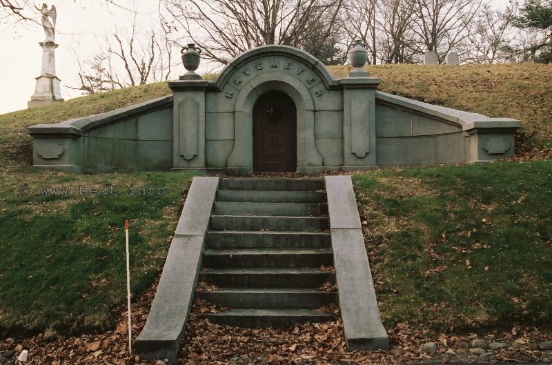
Havemeyer
family vault
Green-Wood Cemetery, Brooklyn, NY - 26 January 2010
authors photo
.
.
Henry Osborne Havemeyer, nephew
Henry's nephew, also named Henry Osborne Havemeyer, (to whom I formerly referred to as "the younger") would become instrumental in guiding the Brooklyn Eastern District Terminal. Nephew Henry and his wife Charlotte, would have a son, whom would be named (you guessed it) Henry Osborne Havemeyer as well. He was the third male to carry the name Henry Osborne, but since this latest edition of the Henry Osborne heritage is actually the son of the nephew, I will refer to him as Henry Jr.
Henry Sr. and his wife Charlotte would
collect Americana, including paper currency, pamphlets, coverlets,
manuscripts,
snuff boxes, portrait busts, cartoons, medals and prints. Henry donated
to
the New York Historical Society, thousands of portraits of
prominent
Americans. These items are still on
display.
.
.
Henry Osborne Havemeyer Jr., by the way, would also go work for the Brooklyn Eastern District Terminal, and hold the position of assistant to the President.
Keeping true to the Havemeyer's family contributions to railroading (whether infamous or beneficial), Henry Jr's. claim to fame would be that he invented an apparatus for float bridge and carfloat track alignment and mating, and he applied for and received patent #1,591,086 for this device in 1926. Paul Strubeck located the following patent application in one of searches.
Basically, this device is similar in principle to a "guarded frog" on a turnout, but his design was not a "V" as used in a frog situation, but rather a simple guard on one side of the rail to prevent derailments when the wheel set of a freight car transgressed from the float bridge rail to the carfloat rail.
His patent application better explains
the device, so I highly recommend you view the patent drawing and
application
here:
.
H. O. Havemeyer Jr., Patent
Application; December 29, 1925
.
I am also at this time, going to ask that any descendants of the Havemeyer family please take the time to contact me at bedt14@aol.com
..
.
The
Havemeyer's and their relatives
(Townsend's, Elder's), through consolidation of their 15 sugar
refineries
and through their political connections, would eventually become known
as
the "Sugar Trust". They would become extremely successful in the
business
world of America.
The success of the Havemeyer's is not to say that
the Havemeyer
and Elder sugar interests were without tribulation or scandal. As
mentioned
above, there were many investigations and indictments throughout their
early
history. Speaking frankly, it appears that the Havemeyer's almost
always
seemed to be embroiled in some legal folderol.
These lawsuits varied greatly in topic, and most
were filed
in connection either with: receiving secret rebates from other
railroads,
fixing sugar prices (after the City of New York failed to), and in an
under-weighing scandal. Located in Theodore Roosevelts' (yes, the 26th
president
of the United States) autobiography, this author uncovered the
following:
.
Theodore
Roosevelt (1858–1919). An Autobiography.
1913. To read the complete details and decision of this lawsuit in it's entirety, please click on following link: THEODORE ROOSEVELT AUTOBIOGRAPHY (please note: there is no link to return you to this website - use your back/previous arrow on your browser) |
.
East River Terminal Railroad;
1907 - 1915
.
Upon my initial
research for this website
many years ago, the name "East River Terminal Railroad" appeared
infrequently
if hardly at all. The first and only reference to it
that I had
come across, was in the 1990 Semaphore newsletter by E. M. Koehler,
where
I learned of it. I would not hear the name again until Tom Hendrickson
informed
me he found reference to it, as I will explain below. At first
perception,
it seemed that East River Terminal Railroad was used interchangeably
with
Palmer's Dock; but as it turns out this is not the case.
|
The documentation located and submitted by Tom Hendrickson, clarifies the use of the name East River Terminal as its own entity. Tom located several articles pertaining to the East River Terminal Railroad in the New York Times archives. The first of which relates to it's incorporation and is dated November 20, 1907, and in the principles you will notice that Lowell Palmer is not mentioned. The name appeared once again upon Tom locating it on page 265 in New York Times Index of 1916, where he was also able to find the digital images seen here. So, the navigation aspect of the business was incorporated as the Brooklyn Eastern District Terminal Company (a navigation corporation) on June 22, 1906; while the East River Terminal Railroad was incorporated in the State of New York as a steam railroad company on November 19, 1907. For a long time, I often wondered why the East River Terminal Railroad was incorporated at a much later date, and you will learn why later in this chapter. |
|
.
.
.
|
This next article, states how the Pennsylvania Railroad opposed the expansion of the East River Terminal Railroad, which had now announced it's southward expansion below North 5th Street to North 4th and North 3rd Streets. This article can be seen here to the right. Is it not ironic how the mighty Pennsylvania Railroad would oppose this two block expansion, of this "little" terminal railroad? Well the mighty Pennsylvania thought that by the East River Terminal Railroad expanding to south of North 4th Street, it (the PRR) would be encircled by East River Terminal Railroad trackage thereby preventing it from expanding either its trackage or its freighthouse as well as restrict truck / trailer movements on it's property. Granted, some of these concerns held validity. Evidently, history clearly shows that the Public Service Commission allowed this expansion, as this new trackage would be in place in 1915 for the opening of the Austin Nichols Building between North 3rd and North 4th Streets on Kent Avenue. |
|
.
.
|
Oddly, in an another New York Times article, the Havemeyer
& Elder principals: Henry O. (the nephew); Theodore A.;
Frederick C.; and Horace Havemeyer are apparently trying to
publicize the "disassociation" of the East River Terminal Railroad
(owned by Havemeyer's & Elder) from the American Sugar Refining
Company (of which we already are aware that the Havemeyer's are / were
involved in).
Not only is Henry O. stressing that the East River Terminal Railroad has no connection to American Sugar Refining, but he is also stressing that the East River Terminal Railroad has no interests in the Havemeyer & Elder Sugar Refinery, which is stated here to have been sold to American Sugar. Notice how Henry O. states that East River Terminal Railroad holds the franchise rights for the tracks in the streets, and handles the cars of the Brooklyn Eastern District Terminal, a corporation, all of whose stock is owned by Havemeyer's & Elder. The reasons for this public disassociation from American Sugar Refining are unclear, but the end result is transparent enough: to establish the East River Terminal Railroad and related railroad properties as a completely separate entity from the American Sugar Refining, which at this time is still embroiled in the under-weighing scandal, and sugar trust investigation. This disassociation could also have been a tactic to separate the East River Terminal Railroad from the lawsuits that the United States Courts were pursuing against American Sugar for receiving secret railroad rebates from the New York Central & Hudson River Railroad, among other railroads as well. As a result of this article seen to the right, we are now able to determine that the Havemeyer & Elder group incorporated the Palmer's Dock venture, which they had gained control of, into two separate entities and this took place not long after Lowell Palmer left the Palmer's Dock organization in 1905. |
|
.
East River Terminal
Railroad Property Photos - What It Looked
Like!
While the average reader might not comprehend, any images of the Brooklyn Eastern District Terminal prior to the late 1950's and likewise, its predecessors; are quite scarce. The reasons for this are unclear, as there appears to be sufficient images of other railroad facilities, equipment and installations of this era. So, it is with unbridled excitement, that I add the following images to this website for all to enjoy.
The top one was located by none other than our very own retired BEDT engineer, Joe Roborecky; who has been contributing more than his fair share of assistance in research. Ironically, he located it on a "Google Book" search, even though I had searched their archives many times before!
The image was taken circa March or April 1914 and actually comes from the April 6, 1914 issue of the weekly publication: "Greater New York - Bulletin of the Merchants Association of New York".
While this photo might not technically be an aerial photo, it is definitely not taken from ground level either. At first, both Joe and I thought the image was taken by hot air balloon. This hot air balloon method had been used to photograph the Bush Terminal railyard, and of which that image may be seen on that particular page.
We also believed we were looking at the North 5th and North 6th Street Yards, with the Austin Nichols building being the background. It was only upon reading the accompanying article that we discovered that the Austin Nichols building was still being planned, and not yet constructed.
This threw off our pinpointing the location until we referenced the property maps in the Terminals, Facilities & Yards chapter of this website. It was then we realized that we were looking at the northern portion of the property, (North 7th through North 9th Streets) and not the southern portion (North 4th - North 6th Streets) as originally believed.
By referencing the 1907 / 1908 Bromley Property Map, Joe and I were able to hazard a guess from where this image may have been taken: the top of the grain elevators of the Brooklyn Elevator and Mill! As Palmer's Hay Storage building was only three stories tall (which is believed to have become the North 10th Street freighthouse), it would not have afforded the higher perspective of the wood trestle in the photo, which is at least two stories tall in itself.
The only structure that would have been tall enough for one to "look across" at the roof of the Brooklyn Cooperage building (in the background) would be either a similarly tall building, a water tower, or a coal or grain elevator. Of these, we do know there was a grain elevator on North 9th Street and the bulkhead by referencing the 1907 / 1908 Bromley Map.
Anyhow, this fantastic picture shows a
great many interesting details which we may now revel in;
.
The image, which is looking south from North 9th Street and shows in the background, the multi-story Brooklyn Cooperage building and faintly, the Williamsburg Bridge;
Directly across from the Brooklyn Cooperage building, is the covered pier shed of Palmer's Dock;
Several stick lighters about the Palmer's Dock pier
The western portion of the North 7th and North 8th Street railyards, and;
A small steam locomotive (left side of the photo, about the horizontal centerline) can be seen in the image. It appears to this author, judging from the proportions of this locomotive; that it is one of the earlier 0-4-0T saddletankers (this locomotive looks remarkably similar to the Harlem Transfer #1 0-4-0T, also of Baldwin manufacture);
Two different types of lighters and a coal barge at the bulkhead of the North 7th Street yard;
In the foreground, is a wood trestle extending out and onto a covered pier shed, of which this elevated trackage and trestle was previously undocumented and unknown to us (we now realize the Coal Depot was multistory and served by this very trestle).
.
If the viewer takes notice, there are no
float bridges visible
in the image. This is because the North 9th Street float bridge is out
of
view below the photographer, which was located practically at the foot
of
the grain elevator, (from where it is believed this photo was taken
from
the roof of); and the North 5 and North 6th Street float bridges are
out
of view just behind the Brooklyn Cooperage building.
One must also keep in mind, according to the 1907 / 1908 Bromley Map, the two yards (North 4th through North 6th and North 7th through North 9th Streets were segregated and not connected, with the Brooklyn Cooperage building dividing the property and railyards. This is apparent in the photo below.
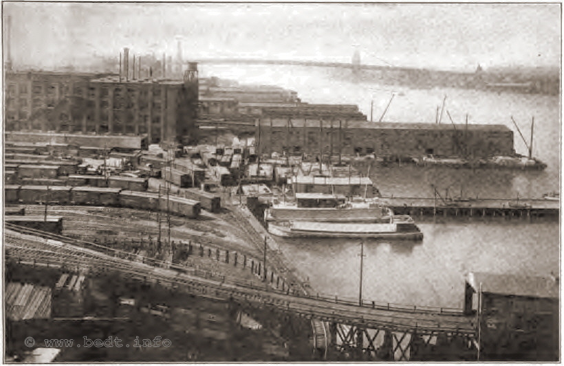
East River Terminal Railroad / Brooklyn Eastern District Terminal -
circa March or April 1914
Looking south.
.
.
A link to
a subpage containing the complete
article accompanying this image is below. It is a multi-page article on
the
Brooklyn Terminals and is an interesting read on its own accord. Of
peculiar
note in the article, is that the Terminal is referenced to as the
Brooklyn
Eastern District Terminal, even though technically the East River
Terminal
Railroad exists, which was not yet merged with but leased
to BEDT Navigation
at this time. It also details the facilities of the Bush Terminal, New
York
Dock, Jay Street Terminal and the proposed South Brooklyn Terminal
Railroad:
Now every once in a while, Tom Flagg sends
something to whet my appetite. On May 6, 2009; Tom sent me this image.
It
is from the book "Brooklyn: A National Center of Commerce and Industry"
published in 1914 by the "Committee on Industrial Advancement
of the
Brooklyn League". Tom states the photos might well have been taken the
year
before, or even earlier. But, as both this image and the one above are
of
approximately the same year, 1914; they provides us with two different
views
of the North 9th Street locale. In the image below, (which is facing
east)
many interesting structures can be seen:
.
Multi-story wood construction "Brooklyn Elevator & Milling" feed elevators. Of which by the way are proudly advertising "BROOKLYN ED TERMINAL"! It is from the top of this structure that the photo above was taken.
Behind this feed elevator is the three story brick structure which at the time of this image, was utilized for hay market & storage. This structure would become the North 10th Street Freight House. This was the only structure in this part of the property which survived into the "modern era" of BEDT operations.
Moving right, we have BEDT Carfloat #14 moored to the North 9th Street float bridge and North 9th Street Yard. One must keep in mind, at the time this image was taken, BEDT was the navigation company handling marine transportation, and the East River Terminal Railroad would be the railroad aspect of operations.
Between the float bridge and ramp for the coal trestle, is a two story structure. It was undetermined what purpose this structure served until Tom furnished a copy of the 1905 Sanborn Fire Map. It turns out this structure was one of TWO engine houses(!) that were operated simultaneously. (This one by North 9th Street and the other by North 5th Street.)
To the right of the of this structure, is the brick North 9th Street freight house running up the north side of North 9th Street.
Looking down the coal trestle ramp, we look directly down (east) on North 9th Street.
Slightly to the right we are looking up the trestle ramp, through the "covered bridge" / shed, of which its purpose is unknown. It is possible this was a location for dumping coal in scows underneath the covered trestle.
Following those tracks through the "covered bridge" leads us to Palmer's Coal Pockets in the background.
Under the inclined coal ramp fan (where the tracks spread out before entering the coal shed) an enclosed shed occupied the space.
The white fence is a stock yard, and there was a cattle shed here as well.
To
the right of this and ground level is the North 8th Street Yard.
.
It is highly suggested that viewers reference the 1905 Sanborn Fire Map, for in depth details to the structures in this area.
In
case this might be a little confusing, please
click on the image below for an annotated copy of the image.
Use your back arrow to bring you back here!
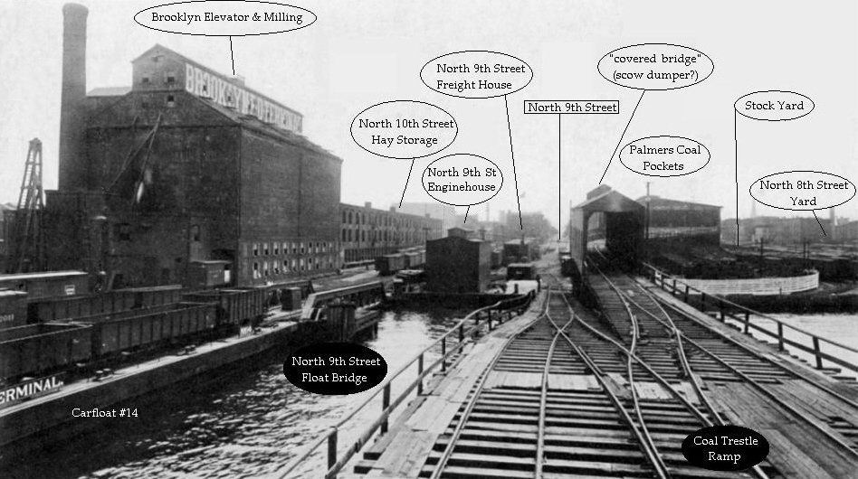
East River Terminal Railroad / Brooklyn Eastern District Terminal - circa 1914
Looking east.
courtesy of Thomas Flagg
added 06 May
2009
.
.
Other than the building on the bulkhead, (which
I learned
from the Sanborn Fire Map was one of two enginehouses); the
purpose
of that white fence eluded us as well. As it appears the North 8th
Street
Yard was not fenced off, why would this section be? This question
remained
unanswered, until I reviewed a 1905 Property Map, where it was noted it
was
in fact a cattle yard. Apparently, this was a facility for the holding
of
livestock until they were "needed" (read: slaughtered) by the many meat
packers
on the side streets east of the terminal.
While the exact date that the photo was taken is not known; judging from the lack of bustle, I would hazard a guess it was taken early to mid morning on a Sunday.
Another interesting fact that arose during research, is the New York Times archives shows that on November 25, 1912, an explosion and subsequent fire destroyed the plant of the Union Sulphur Company located on North 10th Street (between North 10th and North 11th Streets).
Thirty-four persons were injured with and undetermined number perished. Flying embers set fire to the hay market on the opposite side (south side) of North 10th Street. In a statement issued to the New York Times by H. O. Havemeyer, $245,000 worth of damage was done to the Union Sulphur Works, which was insured for $375,000, as well as undisclosed amounts of damage upon the hay market. The upper two floors of the grain elevator were also heavily damaged.
Therefore, there are now two possibilities
pertaining to the Brooklyn Elevator & Mill structure seen
in the
above image:
This image was taken prior to the fire and subsequent damage, or
These structures were
rebuilt.
By referencing the 1924 Fairchild Aerial Photo and the 1929 Belcher Hyde property maps, we can now also see that the BEDT property was totally redeveloped between the date of this photo and the mid 1920's; as no trestle or the covered piershed can be seen anywhere on BEDT property at these dates, and the Brooklyn Cooperage building is no longer shown on maps.
It may be of unique interest to compare even later images, maps and landmarks with this photo. The circular fenced portion of the property just to the other side of the wood trestle, would become the approximate location of the enginehouse we are now so familiar with. Also the point of which the elevated track upon the wood trestle crosses over the track on the ground (running parallel to the bulkhead) is the approximate location of the "diamond" crossover (behind the enginehouse) leading to the North 9th Street yard trackage in the more modern (post 1924) and recognized track layout.
.
The following document was located
by Paul Strubeck. It is a report from the Senate of the State of New
York,
Report of the Public Service Commission, First District and dated 1915
(even
though it was released in 1917). At first I was excited by the data,
then
very confused.
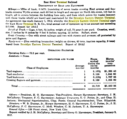
.
If you have not already noticed, there
is some very curious and contradictory details in this document. It
states:
(with my comments in parenthesis):
Miles of Track: 0.1475? (That translates into only 778.8 feet!)
Tracks: 60 feet in length? (Seeing as how the blocks from Kent to Wythe Avenue is 400 feet long, how can that be? Sixty feet wouldn't hold two 35' boxcars... But this report clearly states that 7 tracks cross Kent Avenue and four tracks cross Wythe Avenue, but lists them only as 60 feet in length - the width of the thoroughfares.)
Only one locomotive?
(We know from
builder records several locomotives were purchased in the years before
this document.)
I commenced in writing a long and lengthy "rebuttal" chapter to this data, after consulting the 1907 / 1908 Bromley and 1929 E. Belcher Hyde maps, which clearly show trackage on North 4th Street much longer than the "60 feet" stated in the report. In the end, I deleted the paragraph until I could decide on how to best confirm or disprove this data. Well, that occurred about two hours later when reviewing the following document, which was also located and sent to me by Paul Strubeck.
This document is a request for Permission to Issue Stock and Acquire and Hold the Stock of the Brooklyn Eastern District Terminal (a navigation corporation) and the East River Terminal Railroad (a steam railroad company). It is also a request for permission to exercise its franchise on those two companies. It short, it pertains to the merger of the East River Terminal Railroad (a railroad company) and the Brooklyn Eastern District Terminal (a navigation company) into the Brooklyn Eastern District Terminal (as a freight terminal company).
| Application for Permission to Issue Stock |
.
.
But,
upon cautious reading of this
document, we can finally learn WHY the East River
Terminal Railroad
was created and why its trackage was understated.
.
.
Apparently, the Havemeyer's applied for an expansion of their terminal station to North 4th Street (to build and service the upcoming Austin Nichols building), and such expansion required tracks to cross city streets. This required a certificate of convenience from the Public Service Commission and a franchise from the Board of Estimate. When they filed for the franchise, they were informed that such a franchise to operate railroad tracks in city streets could not be granted to a navigation company, but a railroad company would be allowed to do so; and hence forth the application was denied.
Upon further review of that application, it was determined that the firm who installed the railroad crossings already in place at North 5th Street and Kent Avenue (that firm being Palmer's Dock) did not have such right to do so because the franchise to cross streets by rail was not clear in its statement of incorporation. The right to cross the streets had been granted by the Aldermen of Williamsburg, and apparently never formalized through New York City legislature.
The Havemeyer's was advised to file a new franchise application to the Board of Estimate to clarify that usage. If approved, then the Havemeyer's / East River Terminal Railroad were advised to refile for the certificate of convenience. Well, that franchise application was denied, because the certificate of incorporation previously filed in 1907 by the East River Terminal Railroad was not amended to reflect the railroads intent to expand it's trackage north of North 4th Street (where BEDT Navigation was already operating).
It was also claimed that such an amendment cannot be issued because of a limitation on a railroads width is not to exceed six rods (a rod being 16.5 feet) or a total of 99 feet. The layout of the operations as per the intent of expansion, was seven blocks wide (North 3rd to North 10th Streets), and is in automatic violation of the statute. (It is not stated, and if I understand correctly; this rule applies to main lines and trunk lines and is not applicable to Freight Terminals, of which you should remember that neither the ERT or BEDT was incorporated as such as of this date).
So, the East River Terminal Railroad was organized and with it apparently the Havemeyer's incorporated a company comprised of a 700 foot long railroad with only a few short sidings located along North 4th Street, listed to keep in under the "6 rod" rule (section 8 subparagraph 3 of New York State Railroad Law). Furthermore, a locomotive was leased from BEDT navigation. The result? An instant railroad and the right to lawfully cross city streets, even though the Brooklyn Eastern District Terminal (incorporated as a navigation company) was the company operating a railroad and executing most of the train movements across the streets.
And don't think for one minute the Public Service Commission did not know what was going on here either, as I think the highlighted text says it best:
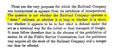
excerpt
from the
Application to Acquire, Merge
and Issue Stock -
Reports of the New York State Public Service Commission - First
District
- 1917
"A
sham railroad!" You have to
admire the bluntness (and humor) of that statement in such a formal and
legal
state agency document!
Seriously though, as I had stated at the beginning of this chapter, I had wondered why the East River Terminal Railroad was incorporated at a later date than that of the Brooklyn Eastern District Terminal (navigation company). Fortunately, it is stated in this application and the facts are now known. Ironically, at the end of all this legal maneuvering and reviewing in 1915, the Public Service Commission granted the application to consolidate all the Havemeyer operations under one name and reissue stock, and the Brooklyn Eastern District Terminal as we know it was born and now incorporated as a Freight Terminal Station, so their tracks and trains could now legally cross city thoroughfares.
In documents pertaining to the corporate history of the Brooklyn Eastern District Terminal as furnished to me by Tom Flagg, which in turn had been supplied to him in an interview with Marion McClelland in December 20, 1976; it is stated that in a contract with the City of New York dated December 27, 1909, the City granted the rights to the East River Terminal Railroad to construct and maintain trackage in North 5th Street, North 6th Street, North 7th Street North 8th Street, North 9th Street as well as Kent and Wythe Avenues. This significantly "expands" the actual trackage in use by the East River Terminal.
|
There is also an interesting coincidence of dates that was brought to my attention by Tom Hendrickson. The Brooklyn Eastern District Terminal was re-incorporated as a freight terminal company on November 4, 1915. Lowell M. Palmer passed away just five weeks prior on September 30, 1915. It is Tom's contention that the Havemeyer's incorporated this new entity to secure full ownership over the properties. The article seen at right, is the public announcement that the Public Service Commission granted the application for permission of the Brooklyn Eastern District Terminal (as a freight terminal company) to issue and hold stock of the Brooklyn Eastern District Terminal, a navigation company, and the East River Terminal Railroad. This application has the effect of consolidating those two entities (as described in the application in link above). As a result of this new information, it is believed and hypothesized that the Havemeyer's initially incorporated BEDT Navigation and ERT Railroad as two separate entities to protect and isolate either company from the other as a result of lawsuits, claims or negative attention from the Sugar Trust scandals among other things. Upon the death of Lowell Palmer and the settlement of the sugar trust problems; perhaps the Havemeyer's decided that those threats were no longer a factor and could consolidate the two entities. |
|
.
.

Brooklyn Eastern District
Terminal; 1906 - 1983
.
.
The name Brooklyn Eastern District Terminal as we know it, had its true beginnings in 1906 as a Navigation Company, and in the very beginning was incorporated as such under the Transportations Corporations Law of the State of New York on June 20, 1906.
It was not until the November 5, 1915, after all the franchises and certificates of conveniences were finally approved; that all the properties, railroad, marine equipment and other assets were formally consolidated and incorporated under the name by which we know it and as a Freight Terminal operation; with a railroad, tugboats and carfloats. As previously discussed in the chapters above, the name by which we know had its beginnings in 1906 and until 1915, and between those dates; generally referred to the navigation corporation operated by the Havemeyer's, even though it was operating a railroad along Kent Avenue.
Paul Strubeck located some information in the following documents. The following is a summary and pier dimensions as listed in "Ports of the United States, 1916", and it makes a good overview.
|
"The Brooklyn Eastern District Terminal was probably the first private terminal for public use in the Port of New York. According to well authenticated report, this terminal had it's beginning in 1876. This organization has three terminals. The main terminal is located on the East River in Brooklyn and includes frontage between North Third and North Tenth Streets. Of the branch terminals on is on the Tidewater Basin in Jersey City and the other known as the Queensboro Terminal, on the East River, between Thirteenth and Fourteenth Streets in Long Island City. The main terminal of the Brooklyn Eastern District Terminal is adjacent to the large refineries of the American Sugar Refining Co. and to other important manufacturing concerns and occupies an area of about 740,000 square feet. This terminal has one large covered pier for steamship freight and six open piers, in addition to four car-float bridges. The yard capacity of the main terminal is 1,500 cars and the equipment includes 10 locomotives, 13 car floats, 12 lighters, and 5 tugs. An interesting feature is the operation of the car floats on a regular schedule. The main terminal has a hay-storage warehouse with a floor area of 37,250 square feet and two warehouses for the storage of flour and package freight, one being 450 feel long, 75 feet wide, and three stories high, while the other is 120 feet long, 75 feet wide, and four stories high. This terminal is equipped with coal pockets of 35,000 tons capacity and with three cranes, two of 10 tons and one of 20 tons capacity, for handling heavy freight. The Queensboro Terminal occupies a river frontage of 419 feet and has a long wharf and wharf shed. This terminal has only recently been established. The Jersey City Terminal of this company is located at the foot of Warren Street on the Tidewater Basin of the Morris & essex Canal. This terminal has direct connection with the various railroads having terminals on the New Jersey shore of the New York Harbor, and has a freight yard with a capacity of 100 cars, car-float bridges, and warehouses for the storage of freight." |
Ports
of the Unites
States, 1916
Department of Commerce - Bureau of Foreign & Domestic Commerce
Miscellaneous Series - No. 33
Report on Terminal Facilities, Commerce, Port Charges,
and Administration as Sixty-Eight Selected Ports
by Grosvenor M. Jones.
.
Details
as to the dimensions and
occupants of the piers of the Brooklyn Eastern District Terminal that
appear
in this book at this point are listed in the
Terminals,
Facilities & Yards
chapter of this
website.
.
.
Non-Erie Beginnings a/k/a
True Independent
.
To this day, many BEDT fans unfortunately still go by the misinformation that the BEDT was originated by, and / or was; an Erie Railroad operation. On Bill Russell's "Pennybridge" website (which is no longer on world wide web), it had been stated that:
"the BEDT was organized by the Erie Railroad".
.
In Jay Bendersky's book, "Brooklyn's Waterfront Railways" it states,
"In 1906 the railroad, with the leadership of mighty Erie, would be reorganized into that railroad with the unusual name: the Brooklyn Eastern District Terminal".
.
Bendersky goes on to infer a BEDT association with the Erie simply by judging from the design of the early BEDT herald / logo style below (diamond with side bars);
"The herald of the BEDT obviously came from its mentor, the Erie".
![[Image]](http://members.trainweb.com/bedt/bedt/erieherald.jpg) |
![[Image]](http://members.trainweb.com/bedt/bedt/bedtoldlogo2.gif) |
In any case, this "Erie involvement" or "Erie origins" information is, by all historical accountings uncovered and known to date, is simply not true. The similarities between the heralds is perhaps an honor to their (Lowell Palmer & Erie Railroad's) first business dealings, or is simply a coincidence. (Bush Terminal's 80 ton GE locomotives bore a three stripe paint scheme bearing a striking resemblance to the "Five Stripe" scheme as seen on the GG1 electric locomotives of the Pennsylvania Railroad. Should we now infer Bush Terminal to be of Pennsylvania heritage based on this similarity?)
Anyhow, this Erie origin misinformation
is perhaps the most prevalent error in the previously published history
of
the Brooklyn Eastern District Terminal. Therefore, I am going to
disprove
this "Erie ownership / operation" with several points of easy reference
through
the following documents and historical facts. My comments appear below
each
point in italics.
Congressional Sugar Trust court proceedings and Palmer's own testimony; 1911
Ambrose Armbruster's Williamsburg Brooklyn historical accountings; 1912
Corporate history of the Brooklyn Eastern District Terminal furnished (by the BEDT in 1976) to Tom Flagg; dated 1919
Brooklyn Daily Eagle Business Review article of November 4, 1925
Miscellaneous facts
.
While Lowell Palmer established a terminal on North 5th Street and subsequently leased a building to the Erie Railroad in 1874; the property, railyards and operation were under the sole control of Lowell Palmer until 1875.
It was at this time that Lowell Palmer formed a partnership with the Havemeyer's.
Also in 1875 other railroads came to lease property from Palmer as well, as discussed in the chapter on the history Palmer's Dock.
.
1)
Lowell Palmer's Testimony in the
Congressional Hearings of the Sugar Trusts - 1911
Perhaps the most important supporting evidence to refute this misinformation, would come directly from Lowell Palmer himself. At the Congressional "Sugar Trust" hearings in 1911; Lowell Palmer testified to the following:
"When I commenced, Havemeyer's station was at St. John's Park, N.Y., so they had to cart and have ferriage on every pound of sugar shipped by rail; and that seemed to be an unfair arrangement and I brought in the Erie in 1874; I brought in the New York Central, I guess, in 1875; then the Central brought the West Shore, and that year they brought in the D. L. & W. and the Pennsylvania, and the Pennsylvania came and bought a block of ground adjoining that property."
Quite simply; there you have it. Palmer
"brought in" the
Erie in 1874 and other railroads in 1875. The Erie did not bring him
(or
the Havemeyer's for that matter) into an agreement, arrangement or
terminal.
Palmer's Dock had already been established in 1870 when he brought in
the
other railroads, five years later.
.
2) "The Eastern District of Brooklyn", by Ambrose Armbruster - 1912, 1941
As discussed previously in the Palmer Dock history chapter, according to the publication "The Eastern District of Brooklyn" by Ambrose Armbruster; Lowell Palmer would establish a terminus on his property, for the Erie Railroad in Williamsburg in 1874.
Palmer's Dock would have exclusive business dealings with Erie Railroad 1874 through 1875, at which time Palmer become host to many other railroads.
Palmer would sell the North 5th Street freighthouse outright to Erie and this structure is shown below in the 1907 Bromley map still marked for Erie, but was now only accessible by the West Shore Railroad yard at North 5th and North 6th Streets and not by Palmer's Dock tracks north of North 7th Street. In the Belcher Hyde maps of 1929, this same structure is now marked as part of the BEDT.
Furthermore, upon referring the 1907 Bromley map, one will see no less than four trunk line / class 1 railroads now on Kent Avenue around the time of formation of BEDT: Pennsylvania, West Shore, Erie and Central Railroad of New Jersey. Pennsylvania and West Shore would have trackage and yards on Kent Avenue pre-dating BEDT, and the Erie and CRRNJ would have freight depots only.
If the BEDT was truly Erie owned property or an Erie owned operation, why would they (the Erie RR) allow competing railroads to lease property on their site?
.
3) Corporate Documents of the Brooklyn Eastern District Terminal
Tom Flagg was furnished with several documents in his December 1976 interview with BEDT President Marion M. McClelland, which subsequently have been furnished to this author.
One of these documents, is the Corporate History of the Brooklyn Eastern District Terminal, dated 1919. This document was prepared by the Brooklyn Eastern District Terminal, in accordance with the requirements of Valuation Order #20, issued by the Interstate Commerce Commission on May 13, 1915.
Nowhere in the eight pages of this document, is it mentioned that the Brooklyn Eastern District Terminal was organized by or owned in whole or in part by the Erie Railroad.
.
4) Brooklyn Daily Eagle newspaper article
The following is an excerpt of a lengthy feature article on the success of the Brooklyn Eastern District Terminal. This article appeared in Business Review section of the November 4, 1925 issue of the Brooklyn Daily Eagle Newspaper. The article can be read in its entirety here: Success Story.
This article covers the rise of the Brooklyn Eastern District Terminal through it's auspicious beginnings under Palmer's Dock:
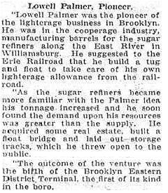
Take exceptional note of the following two sentences:
"He suggested to the Erie Railroad that he build a tug and float to take care of his own lighterage allowance from the railroad."
"He acquired some real estate, built a float bridge and laid out storage tracks, which he threw open to the public."
Need I say more?
.
5) Miscellaneous Facts
1875: Other foretelling facts, if one checks their railroad history; Henry O. Havemeyer (the uncle) would serve as president of the Long Island Rail Road beginning in 1875 and hold that position for one year. The LIRR as we have seen; would go on to have an association with the Pennsylvania, and use PRR designed equipment. But again, this involvement apparently did not reflect on Palmer's Dock operations.
1899: There would also be an announcement in the Brooklyn Eagle of a joint Long Island Rail Road / Palmer's Dock development of a freight terminal at the Pidgeon Street property acquired that same year by Lowell Palmer. No mention of Erie Railroad being involved which should be the case if Erie owned or operated Palmer's Dock. You can read the article in the Pidgeon Street chapter: Pidgeon Street.
1906: The Rebate Scandal and subsequent court trial involving the New York Central and American Sugar Refining (Havemeyer), shows where the American Sugar Refining Company received unfair rebates from the New York Central Railroad in transporting sugar.
If Palmers Dock or the Brooklyn Eastern District Terminal was Erie owned or controlled, why would they enter into agreements with the LIRR (the competition) and why then was the sugar shipped by New York Central (another competitor to the Erie) and why would the Havemeyer's negotiate with the New York Central for illegal rebates when the Erie could have simply transported it for free or reduced cost?
1910's - 1929: At some point, the North 5th Street freighthouse that had been sold to the Erie Railroad, would be repurchased by the Brooklyn Eastern District Terminal on an as yet unknown date (but presumably around 1907-1910). This as already mentioned, is reflected by the G. W. Bromley map of 1907 where the freighthouse is seen marked for Erie.
The E. Belcher Hyde maps of 1929 where
the freighthouse is now seen with the label of Brooklyn Eastern
District
Terminal.
1950's: Another popular contention that the Brooklyn Eastern District Terminal was directly involved with the Erie, would be that the BEDT leased a tugboat from the Erie while their tugs were under servicing.
But if one reflects upon history once again, documents show that the BEDT would contract with the Central Railroad of New Jersey for major locomotive repairs, as evidenced by the firebox explosion incurred by #14 in 1953.
Also the records and testimony in many court proceedings and lawsuits throughout the twentieth century; state that the East River Terminal Railroad, and likewise Brooklyn Eastern District Terminal was owned wholly by the Havemeyer & Elder Co. since 1906; and was formed as the result of the previous merger of Palmer's Dock and Havemeyer & Elder, and the subsequent success of that merger and business interests.
Prior to the formation of Conrail in 1976, Joe Roborecky recalls that one of the BEDT diesel locomotives was sent by carfloat to the Long Island Rail Road facility at Long Island City to have its wheel sets turned to return them to AAR contour specifications.
.
Conclusion:
As history and research have revealed thus far, other than those very early pre-Havemeyer & Elder days and business transactions regarding freight movements; Palmer's Dock and its successors; the East River Terminal Railroad and the Brooklyn Eastern District Terminal were not created, controlled, organized or administered to by the Erie Railroad.
In short, the Brooklyn Eastern District
Terminal, apparently (and obviously) remained truly
independent
of trunk line / class 1 influences, even though it would rely on many
of
those trunk line / class 1's for it's business, purchase of surplussed
marine equipment and intermittent
assistance
in heavy maintenance.
.
.
The Brooklyn Eastern District Terminal, like the Palmer's Dock / East River Terminal Railroad it descended from; was carfloat operation and a terminal railroad with no direct physical connection (interchange) to any other railroad. Yet it was interestingly enough would become a two state shortline (New York & New Jersey), and at various points in its history, would be classified as either a Class 2 or Class 3 railroad by the Interstate Commerce Commission. It was also known as a "contract terminal".
A contract terminal, in a broad scope and layman's terms, is defined as a company that is contracted by larger railroads to perform the final delivery aspects of shipped freight. As such, since the large railroads (Erie, CRRNJ, NYC, etc.) did not have freight terminals in Brooklyn, they would contract with the Brooklyn Eastern District Terminal (and likewise, Bush Terminal, New York Dock and Jay Street Terminal) to pick up freight from the trunk line / class 1 railroads facilities in New Jersey, and forward said freight to the respective consignees in Brooklyn.
On 13 March 2010, Joe Roborecky located the following advertisement in the May 20, 1911 edition of the Brooklyn Daily Eagle:
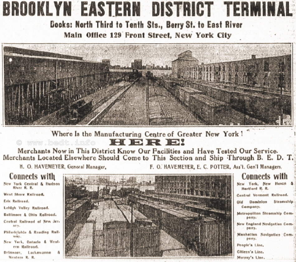
Brooklyn Daily Eagle -
May 20, 1911
The BEDT would not be a common carrier for many
years, at witnessed
by the court document below, but it would achieve common carrier status
by
1940. Prior to being named a "common carrier", the BEDT (and Bush
Terminal
and New York Dock with it) was classified a Contract Terminal. This
meant
that the company (BEDT in this case) was functioning as an agent of the
trunk
line / class 1 railroad that was shipping the item via BEDT carfloat.
I have located the following information, in of all places; an old lawsuit in which the BEDT was a respondent in a case for allowing an employee to remain on duty for more than 16 consecutive hours; (in violation of the Hours of Service Act). Conveniently, this lawsuit accurately describes the operations of the BEDT, and it's business arrangements with other railroads. Pertinent excerpts have been included here for informational purposes.
US v.
Brooklyn Eastern District Terminal, 249 U.S.
296 (1919) |
.
.
The
Highway Connection (that never
was)
On 14 January
2010 while during research
for the New York Dock Railway regarding the construction
dates for the
Brooklyn Queens Expressway (or "BQE" as it is more commonly called
among
urban New Yorker's); it was learned that the City of New York
originally
intended to construct a "spur" of the BQE to the Williamsburg
waterfront.
In 1940, it was proposed to construct the Brooklyn Queens Expressway and connect it to the already completed sections of the Gowanus Expressway (in the south) and the Meeker Avenue - Queens Boulevard section of the BQE (in the north). It is stated on Steve Anderson's website "NYC Roads" on the Brooklyn Queens Expressway page, that one of the proposals put forth by the New York City Planning Department for extending the BQE south of Meeker Avenue:
"The city plan included a "North 9th Street Connection," an elevated highway spur along North 9th Street that was to connect the mainline highway with Wythe Avenue. It was to provide access to an industrial area along the Williamsburg waterfront."
.
.
As I was on the telephone at that very minute with Joe Roborecky and read him that passage, his immediate comment reflected the conclusion I had already come to while reading:
"industrial area along the Williamsburg waterfront" = BROOKLYN EASTERN DISTRICT TERMINAL!
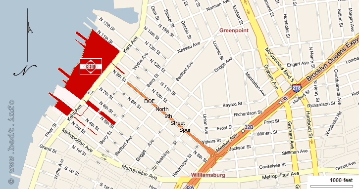
authors
rendering of proposed
Brooklyn Queens Expressway
North 9th Street spur
added 14 January 2010
.
It does not even take a great leap of imagination for one to see this BQE spur even points like an arrow at the Brooklyn Eastern District Terminal. Had this North 9th Street Spur of the BQE been constructed; the Brooklyn Eastern District Terminal would have seen and enjoyed a dramatic increase in freight traffic.
There is no doubt that this elevated highway spur would have made it extremely convenient for tractor trailers to enter and exit the limited access highway system and connecting Brooklyn and Queens along with other major arterial highways and water crossings leading to the other boroughs.
All this with minimal interference from vehicular traffic at cross and side streets, as well as pedestrian traffic. Therefore, this spur might have led to the possibility of a successful trailer on flat car (TOFC) operation at BEDT in later years, when that method of transporting trailers by train was perfected and gained popularity.
Logistically, North 9th Street which is a one way street, would have had to have been widened to accommodate the two way elevated highway. This would not have been an overly difficult feat for the City of New York, as they widened other thoroughfares for identical purposes through condemnation proceedings.
Therefore, North 9th Street would have most likely have become two way for the one block remainder of the distance from the end of the expressway spur at Wythe Avenue to Kent Avenue. More than likely than not; North 9th Street would have become two way the entire distance from Meeker Avenue to Wythe Avenue as well, and would have either run under or to the sides of the elevated highway.
Sadly, this Brooklyn Queens Expressway North 9th Street Spur would not become part of the finalized plan, and the current route of the expressway was what would be constructed and as it exists today.
Success of the Brooklyn
Eastern District Terminal
The success of
the Brooklyn Eastern District
Terminal could be measured by many factors, not the least of which
being
haulage, gross revenue, expansion and appearance.
For example, in 1912, according to the "Report of the Committee on Terminals and Transportation of the New York State Food Investigating Commission" published 1913, the track capacity of the Brooklyn Eastern District Terminal increased from 357 cars to 426 cars.
In 1914: it hauled over 150,990 tons of freight, for 1,200 shippers and 1,400 consigners and operated over 10.33 miles of track in New York & New Jersey. It operated 10 locomotives, 4 tugboats, 19 carfloats and employed 458 employees.
I have been fortunate to locate a Public Service Commission Summary of Annual Returns for First District Operating Steam Railroads for 1920. These reports compare and tabulate the economic figures for the different Freight Terminals & Steam Railroads that operated in Brooklyn & Queens: Brooklyn Eastern District Terminal, Jay Street Connecting, New York Dock, Degnon Terminal and New York Connecting. Oddly, Bush Terminal is not listed. You will note some interesting facts in these reports, such as the Brooklyn Eastern District Terminal handling 59,022 cars, over 9.24 miles of a track (a decrease of .63 miles form the previous year) with a gross income of $853,507.01. There were 115 employee injuries and 1 employee fatality listed for the Brooklyn Eastern District Terminal for that year.
Public Service
Commission - Summary of Annual Reports - 1920
On 13 March 2010; Joe Roborecky located a rather interesting feature article concerning the success of the Brooklyn Eastern District Terminal in an online archive. This article was originally published in the "Business Review "section of the November 4, 1925 issue of the Brooklyn Daily Eagle newspaper.
What I find most satisfying, is the content of the article bears out most of the conclusions I have reached through independent research some 85 years later! Unfortunately, the author of this feature article is not attributed so I cannot even belatedly thank this person for recording the statistics and great information:
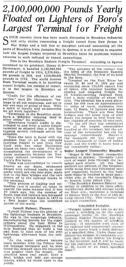
November 4, 1925 -
Brooklyn Daily Eagle
.
.
In 1954, as reported in the New York Times Article
below; the
Pennsylvania Railroad applied to the Interstate Commerce Commission to
abandon
their North 4th Street Freight Station. The Pennsylvania
Railroad subsequently sold that property to the Brooklyn
Eastern District
Terminal. I find it ironic how the Pennsylvania Railroad opposed the
expansion
of the Brooklyn Eastern District Terminal back in 1909; and now some 45
years
later, the BEDT was acquiring the property.
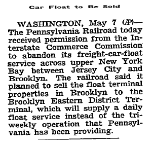
New
York Times - May 8,
1954
.
.
The Coverdale & Colpitts Report of 1956 very nicely lists the trends in Revenue & Traffic on page 7. I have recreated a portion of that table here:
|
year |
total revenue |
loaded cars |
poundage |
| 1935 - 1939* | $1,381,000 |
46,674 |
2,002,000,000 |
| 1940 - 1944* | $2,175,000 |
59,627 |
3,059,000,000 |
| 1945 - 1947* | $2,238,000 |
53,536 |
2,963,000,000 |
| 1948 - 1950* | $2,571,000 |
45,207 |
3,391,000,000 |
| 1951 | $2,749,000 |
44,908 |
2,375,000,000 |
| 1952 | $2,779,000 |
43,347 |
2,232,000,000 |
| 1953 | $2,714,000 |
42,274 |
2,130,000,000 |
| 1954 | $2,398,000 |
38,471 |
1,874,000,000 |
| 1955 | $2,680,000 |
42,386 |
2,112,000,000 |
* = average for years shown
In 1959; according to the Railroad Magazine
article by Melvin
Krampf, the BEDT would switch 27,000 carloads, and exceeded a gross
income
of $2,500,000.
Considering the fact that this railroad would never have more than 11 miles of track, defines this organization as a resounding success. Their equipment was always in good repair and prior to 1935, all of the locomotives, tugboats or carfloats were purchased new.
Another measurement of their success, would
be in its property expansions and acquisitions:
In
1906, the East River Terminal / Brooklyn Eastern District Terminal
would expand
and build a float bridge and terminal at Pidgeon
Street, Long Island City.
In 1910, ERT/BEDT opens the Warren Street Terminal in Jersey City.
In 1914, ERT/BEDT opens the Queensboro / 13th Street facility between Astoria and Long Island City.
In 1915, the Austin Nichols Building (a Havemeyer owned property) opens.
In 1936, BEDT opens its Wallabout Market Terminal just north of the Brooklyn Navy Yard.
In 1940; BEDT assumes operations in the Brooklyn Navy Yard.
In 1954, BEDT acquires the PRR North 4th Street Terminal Property.
In 1964, BEDT opens its Bulk Flour Terminal on Kent Avenue.
Throughout the years,
BEDT would
expand it's way north of North 10th Street in short increments,
to eventually reach North 12th Street.
You can read more about the histories of these expansions in the Terminals, Facilities & Yards chapter.
There is one other way to measure the success of the Brooklyn Eastern District Terminal, if not in a subtle and roundabout method. That would be in its impact on people. In 1933; John J. Bennett, Attorney General of the State of New York; filed suit in the New York State Supreme Court that the Brooklyn Eastern District Terminal did not uphold to it's agreement when it was issued a land use grant some 50 years prior, so the State of New York sought to "evict" the Brooklyn Eastern District Terminal from it's Kent Avenue properties. The details can viewed in yet another of the New York Times articles discovered by Tom Hendrickson here:
State Fails In Court To Seize Terminal - New York Times - May 10, 1933
What perhaps is most amusing about the article is that Justice Lockwood (the judge presiding over this case), as a teenager, had worked at the lumber company at the East River Terminal! Fortunately, Justice Lockwood recognized (and experienced first hand!) the positive commercial & economic impact that the Brooklyn Eastern District Terminal made in Williamsburg.
If the State had been successful in their lawsuit and objective; hundreds of employees would be jobless, the property would be vacant, property taxes no longer collectable, and the State would be stuck with a expanse of land, as even Attorney General Bennett (who was pushing the issue) said the property "would be a white elephant". Perhaps most importantly, if this lawsuit had been successful, my interest in the BEDT would not have occurred and this website would never exist... Oh the horror! :o)
Seriously though, while there were three other terminal railroads in Brooklyn (Bush Terminal, New York Dock and Jay Street Connecting); it is the Brooklyn Eastern District Terminal that people seem to remember most. As Jay Wanczyk pointed out to me in general discussion:
"One
of my
continuing thoughts about BEDT from its earliest
Palmer days to the very end is that the company always seemed to
conduct
its business in a first class business way, no slap-dash operation. The
employees
seemed to be proud of "their" railroad and the company proud of it's
image;
ads in the Official Guide were large and graphic; in the late 1950's
paining
up its steam locomotives "almost too well" in their final years for all
to
see, and later even spending the money and taking the time to erect a
professionally made large red and white flag sign on the flour
terminal.
Reading those new Palmer articles shows that
business leadership
approach seemed to begin with him and of course the Havemeyer's as
well.
I think that approach is what set the BEDT apart and above the other
small
Brooklyn railroads. Of the rest, only Bush Terminal seemed to have had
any
wide vision, and that came a bit later and still was not as broad in
it's
approach. At the very end though, it appears that NY Dock had the
management
that
prevailed."
If this astute business sense on the parts
of Palmer and Havemeyer can be recognized over a hundred some odd years
after
their involvement, I cannot help but feel this is a testament to their
vision
and success.
.
.
End Of Steam Operations
Ceremony
.
Eventually, Diesel-electric locomotives became the standard for all railroads. In the New York area, it is often attributed to the Kaufman Act, which was an attempt to ban steam locomotives operating in the City of New York.
But this is not the case.
Diesel-electric locomotives took over as the choice for locomotive power due to their ease of operation, efficiency, ease of maintenance and repair and common availability of parts. The railroad did not need to hire someone to baby sit the locomotive during off hours to keep steam pressure up as it did with steam locomotives. Yone simply turned the Diesel locomotive on or off; and it was pretty much ready to operate within minutes of starting. No waiting to build up pressure.
Upon the passage of the Kaufman Act in 1923, which in effect tried to eliminate the use of steam locomotives within city limits; those railroads operating with the confines of the City of New York had to turn to alternate methods of motive power. The Diesel- electric locomotive as switcher locomotive had already started to be tested in 1916; but it was not quite perfected. The Kaufman Law hastened the perfection.
Ironically, this became a moot point as the Kaufman Act was overturned as
unconstitutional by the US Statutory Court in 1926. As such the BEDT
never gave up its steam locomotives and continued operating them until
1963.
You can
read the comprehensive history of all steam locomotive restrictions for
the City of New York, beginning 1834 and ending with the Kaufman Act
and its repeal on the main page of this website:
But as we have seen; BEDT would have nothing to do with Diesel locomotives until the last possible moment.
Why the BEDT kept steam power until 1963 still remains to be learned, but it could very well have to be due to the fact that around the early to mid 1930's, the steam locomotives operating on the BEDT were converted from coal fired to oil fired, more specifically Bunker-C oil. As we can see from the many hundred of photos of the steam locomotives operating, they appear to be clean burning; and because the fuel was being used in the tugboats, so it was economical.
Eventually, BEDT would have to end steam locomotive operations. This was attributed not to the Kaufman Act, but to the fact that parts for the steam locomotives were becoming scarce, exceedingly expensive to make, or in some cases impossible to acquire.
Also to be considered is that the boilers of the steam locomotives could only be certified for so much service before having to be rebuilt. As BEDT would have to shop out their heaviest rebuilds, but as the trunk line railroads gave up steam and re-equipped their shop for diesel, and they would not be equipped any longer for a steam locomotive rebuild, leaving BEDT with no one to turn to for heavy steam repairs.
Regardless of the reason, the day that steam operations on the BEDT ended sadly came on October 25, 1963; when BEDT ceased all steam locomotive operations with #14 and #16 both being the last steam locomotives to operate on the BEDT as part of the "end of steam ceremony". Furthermore, the administration of the BEDT recognized this event for what it was, and made it a public event. The event would be well recorded by many railfans, and an article would be published in the New York Times. Due to the growing number of pictures I am receiving from this date, and a lengthy newspaper article received from Tom Hendrickson, inspired me to place these items on their dedicated page:
.
.
As a happy footnote to this occasion: all of the H. K. Porter saddletankers would not be scrapped, as the railfan movement was in its heyday. Unfortunately, Baldwin build #10 and #11 were already gone. Several parties sought out and purchased the remaining saddletankers for preservation and use on tourist railroads.
That is all except #16, who would sit somewhat forgotten on Kent Avenue, as a lone testament to the steam operations of BEDT, until her rescue in the mid-1990's, and numbers 10 & 11 that were scrapped prior to cessation of steam operations.

The first diesel locomotive to arrive on Brooklyn Eastern District Terminal property was an S1 model built by the American Locomotive Company (ALCo), in Schenectady, NY. This locomotive was formerly owned and employed at the Union Railroad of Pittsburgh, Pennsylvania as their #453, and it arrived at the Brooklyn Eastern District Terminal Kent Avenue yard in the fall of 1962. Brooklyn Eastern District Terminal would assign this locomotive as number 21, skipping over unassigned numbers 17 through 20.
Three more ALCo S1's would follow over the next few weeks or so, but from another railroad however. BEDT numbers 22, 23 and 24 would come from the New Orleans & Lower Coast Railroad as numbers 9013, 9014 and 9015, which was a subsidiary of the Missouri Pacific Railroad.
The final two locomotives would originally come from the Erie Lackawanna Railroad, numbered 307 and 313, and these would become BEDT #25 and 26 respectively. #25 would arrive in 1968 directly from Erie, and #26 would have a few more prior owners after Erie before winding up at the BEDT as late as 1973. Both of these were ALCo S1's as well.
Having all the same model of diesel locomotive would be beneficial from an operational standpoint, as parts could be shared among the locomotives. Ergo, if one locomotive had a faulty brake cylinder and another had a faulty fuel pump, one part could be taken from one locomotive to make repairs to the other and one of the two locomotives would be able to return to service. This practice is called a parts donor.
The locomotive being used as a parts donor could be on a temporary basis, until spare parts could be purchased; or it could be permanent basis, where the oldest locomotive, the locomotive worst condition or one that was involved in an accident, could be sacrificed and used for parts.
For detailed histories of the locomotives and their specifications, please visit: Equipment Rosters & Specifications.
There were two events associated with
the beginning of diesel operations for the Brooklyn Eastern District
Terminal,
and they are discussed in the next two chapters.
...
one-man steam locomotive operation vs. two-man Diesel locomotive operation
The Brooklyn
Eastern District Terminal
found it necessary to employ "firemen" for Diesel locomotive operations, whereas
the
steam locomotives were equipped for one man operation.
Stated in Jay Bendersky's book "Brooklyn's Water Railways", that by the combination of the long hood and high control stand in the cab of the S1's, visibility was obscured for the engineer and so firemen were hired to assist.
This is not the case as reported by Joseph Roborecky, BEDT engineer (1968-1983).
The reason for hiring the extra crewman, was that New York State had what is known as the "Full Crew Law" on the books regarding locomotive operations, and this law requires firemen to be present on locomotive operations. This law does predate BEDT Diesel-electric locomotive operations, but it remains unknown why BEDT steam operations escaped the use of firemen.
However, in the April 1961 issue of Railroad Magazine, it is explained how BEDT operated with only one crewman (engineer) in their steam locomotives. It simply states:
"New York State's full crew law permits a road having less than 25 miles of track to operate oil burning steam locomotives with only one man in cab; a diesel must have two."
This does
not however explain the
reasoning behind New York State allowing oil burning steam locomotives
to
operate with only one man.
I also understand the law to exempt the use of firemen on diesel locomotives weighing less than 45 tons (90,000 pound rule) which is why I believe the New York Dock Railway to have utilized GE 44 ton Locomotives (which were ballasted to 50 ton). The Alco S1's employed by BEDT after steam operation weighed more than the 44 ton limit imposed by the regulation (the ALCo's weighed 99 tons), therefore necessitating the hiring of locomotive firemen.
To date I have not been able to find a copy of the law anywhere as of yet to verify or explain this.
.
Brought to my attention by Joe Roborecky, was
another side effect
(unforeseen?) resulting from conversion of operation to the
diesel locomotives, and that was
the
enginehouse had to be extended.
The ALCo's were 16 feet longer than the 28 foot long Porters, and even after the diesels had been on BEDT property already one year, the enginehouse was still not extended, and the diesels being stored outside.
By 1967 however (the earliest picture I have, that shows the extension), the enginehouse was expanded to provide more track length inside, so the diesels could now take turns residing inside. This extension was of concrete block and approximately 15 - 20 feet in length, and about two to three feet higher than the brick structure. In the right picture below, you can see the concrete block extension interlaced with the original brick construction on the extreme left of the image.
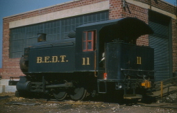 |
.... | 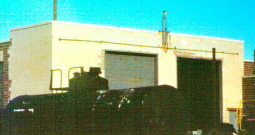 |
|
Original Structure,
|
Concrete
block
extension on east face |
.
.
Causes for the decline of
Rail-Marine traffic in New York City
Several
events hastened the end of
marine-rail traffic in the New York area, in addition to the general
economic
malaise that effected the United States and especially the New
York
Metropolitan area during the 1970's:
.
Robert Moses, who
starting from the late 1920's; campaigned and lobbied
for (as well as built) more roads and large arterial highways in and
around New York City and Long Island. This lobbying paid off post World
War II.
The completion of the
Verrazano Narrows Bridge, and related highway
connections in 1964.
The Brooklyn Navy Yard
closed in 1966, and this probably was the worse
event to occur to BEDT, as Uncle Sam was a major source of rail traffic
and revenue, but the effects of this event would not
be immediately felt.
In 1976; Conrail was created by Congress to reorganize and consolidate the financially troubled Northeast Class 1 railroads (Penn Central, Erie Lackawanna, etc).
.
.
Robert Moses:
Robert Moses was vehemently anti-rapid transit and railroad, and yes; you can blame him and Mayor Fiorello LaGuardia directly for the decline and outright removal of New York City trolleys and streetcars (booo - hisss!) as well as New York's elevateds. Both Moses and LaGuardia had vested monetary interests in Standard Oil, General Motors and other automobile related securities.
Naturally, this proliferation of highways and expressways; while improving the access of truck transportation to the rural and suburban areas of Brooklyn, Queens and Long Island; ultimately led to the decline of waterborne rail / freight traffic and the slow demise of the rail - marine carriers, such as BEDT and the others, even all rail terminals in New York City area; as freight by rail became redundant (and slower) to increasing tractor-trailer access to Long Island.
.
Completion of the Verrazano Narrows Bridge, 1964
If you were to ask me; all NY Metro Area marine - rail traffic really took a nose dive when the Verrazano Narrows Bridge opened in 1964 and the Brooklyn-Queens Expressway connections. (Ironically the Verrazano happens to be one of my favorite suspension bridges).
This new bridge and the associated road connections now linking Brooklyn with Staten Island; of which Staten Island was already linked with the mainland United States via New Jersey, via the Goethals, Outerbridge Crossing and Bayonne Bridges.
Now trucks could drive directly from the piers and wharves in New Jersey (or directly from other parts of the United States for that matter), right into the heart of Brooklyn. This meant that without having to travel the Holland or Lincoln Tunnels or the George Washington Bridge in order to cross the Hudson River into Manhattan; then crossing the East River bridges or tunnel to arrive in Brooklyn, truck traffic could now circumnavigate and avoid the growing congestion in Manhattan and arrive directly into Brooklyn.
.
Closure of the Brooklyn Navy Yard, 1966:
Defense Secretary Robert S. McNamara ordered the Brooklyn Navy Yard and Brooklyn Army Terminal shut down, as a cost cutting move. Even after the efforts of Senator-elect Robert F. Kennedy to prevent the closings, both were to shut down within 18 months. This loss of government freight movement, in addition to the eventual loss of the civilian businesses leasing space in the Navy Yard; took away a substantial proportion of BEDT traffic.
History has forgotten the name, but there was a major supplier of coal located in the Brooklyn Navy Yard for the NY Metro area (including segments of the public school system); as well as the Government buildings in the Navy Yard being heating with those black diamonds, and BEDT would bring in countless carfloats of hoppers loaded with coal destined for Brooklyn and Queens.
.
Formation of Conrail, 1976
For the most part, the economy of the United States was not in the best shape it had been, and the railroads suffered as well. The Class 1 railroads in the Northeastern United States were particularly hard hit:
|
Several of these railroad had parallel routes that were now redundant; others had rail lines severely impacted by the flooding caused by Hurricane Agnes. Here the Erie suffered the worst.
The government "bailed out" these financially troubled railroads by organizing them in 1976 into a single entity: "Consolidated Rail Corporation" or Conrail for short. While Conrail would now handle most of the Northeast United States' freight service, Conrail was not the least bit interested in marine operations, in any way shape or form.
Carfloating for Conrail
- 1976
.
.
Greenville,
NJ
Conrail would take possession of the Greenville, NJ railyard; which had been property of Penn Central and before that, the Pennsylvania RR.
However Conrail was not being the least bit interested in carfloating operations. The decision was made by Conrail to contract out the marine and float bridge operations at Greenville to the most qualified bidder.
According to Joe Roborecky, Conrail came to inspect the Brooklyn Eastern District Terminal operations at Kent Avenue prior to awarding the carfloating contract. Conrail came away very impressed and as a result, BEDT won the contract over New York Dock, for carfloating operations between Greenville and other surviving Marine-Rail interchanges in New York Harbor.
As part of the contractual agreement between Brooklyn Eastern District Terminal and Conrail, the BEDT would now handle the carfloat traffic for themselves, as well as the New York Dock Railway. According to the contract, the Brooklyn Eastern District Terminal would be paid by Conrail to load those carfloats for New York Dock, but would not be for paid for those carfloats loaded for themselves, which was included as part of the contract.
Coming to light in a Brotherhood of Locomotive Engineers / New York Dock / Brooklyn Eastern District Terminal "Arbitration Docket" dated December 15, 1980; is the fact that the BEDT also carfloated for the Baltimore & Ohio Railroad, between Greenville, NJ and St. George Terminal, which was located in Staten Island, NY. Prior to BEDT being awarded the Conrail carfloat contract, New York Dock carfloated between Greenville and St. George as well, according to this arbitration docket. A complete copy of this arbitration docket can be viewed in the Memoirs - Joe Roborecky - Unions chapter.
In the beginning of carfloat operations at Greenville, a BEDT locomotive was sent to Greenville to perform switching duties. However, BEDT locomotives did not have the train brakes operational in the cabs as part of the BEDT Air Brake Policy (see Memoirs - Joe Roborecky - Air Brake Policy). This lack of train brakes made switching operations difficult prior to loading the carfloats.
As a result, BEDT would find the need to lease Conrail locomotives for the loading / unloading of carfloats in Greenville. Several different Conrail diesels would be leased by the BEDT over the years to switch cars in the Greenville yard.
St. George Terminal (B&O), Staten Island
According to the Brotherhood of Locomotive Engineers Union Arbitration Docket dated December 15, 1980; mentions that the Brooklyn Eastern District Terminal had a carfloat route from Greenville, NJ to the Baltimore & Ohio Railroad's St. George Terminal, located in Staten Island.
This previously unknown and undocumented carfloat "route" of the Brooklyn Eastern District Terminal is significant in the fact that the Baltimore & Ohio Railroad, which in fact was still in business in 1976 (however now as a part of Chessie System), had given up its marine operations.
According to Tom Flagg's book (NY Harbor Railroads in Color, Volume 1, page 16), the B&O gave up their carfloating operations in the mid-1970's. This date could very easily be presumed to be when Conrail was formed in 1976 and the Brooklyn Eastern District Terminal won the contract for carfloating operations out of Greenville, NJ.
The St. George Terminal would close in
1980, and thus ending all carfloat traffic to this terminal at such
time.
Combined with the other circumstances mentioned
above, BEDT
began to suffer financially (as would NYD and Bush Terminal railroads
throughout
the latter half of the 1960's), but BEDT managed to keep their heads
(and
their carfloats) above water, and the ink in their ledgers "in the
black".
Bush Terminal would conclude operations in 1971, with New York Dock leasing the Bush Terminal property from New York City in 1972, and Jay Street Connecting was long out of the picture since 1959. BEDT's freight income would continue to diminish, and revenue would continue to diminish throughout the remainder of BEDT's history.
Sometime around 1972, Petro Oil (incorporated as Petroleum Heat & Power Co. of Stamford, CT) purchased the Brooklyn Eastern District Terminal from the Havemeyer family holdings. Petro, which is still in business; is a retailer of home heating oil among other petroleum products. Petro would also own the tank farm (formerly Standard Oil) on the East River and the inlet for Bushwick Creek, which is located just north of North 12th Street and the Brooklyn Eastern District Terminal Kent Avenue Yard.
To reflect this new ownership, the BEDT tugs "Petro Arrow" (ex-NYNH&H "Cordelia") and Petro Flame (ex-NYNH&H "Bumblebee") would be repainted into the Petro red/white/blue scheme. Oddly though, these tugs would have ports of registry in Philadelphia. There is also picture of a tank truck filling up locomotive #21 on the BEDT #21 photo page and that is almost certainly a Petro truck. (Matter of fact, my family used Petro Oil for many years to heat our former home in Brooklyn). On an as yet unknown date, Burmah Oil & Gas purchased the Petro Oil Company. (By the way, Burmah Oil is the proprietary holder of Castrol Motor Oil since 1966 and Burmah Oil is a British held company.)
In 1977; Reynolds Industries (better known to us as R. J. Reynolds Tobacco Company) purchased the Burmah Oil & Gas Co. and Reynolds merged their Aminoil holdings with the newly purchased Burmah Oil. Aminoil, which did not have U.S. based service stations or refineries, would now wholesale refined petroleum products on the East Coast through Petro Oil.
Sometime after this merger took place,
Reynolds / Burmah / Aminol began to suffer financial difficulties due
to
skyrocketing crude oil prices and began to divest itself of it's
non-essential
(and non-petroleum) holdings. This apparently included the BEDT
properties,
and so the BEDT was put up for sale.
In July 1975, the United States Railway
Association released
its "Final System Plan" which in accordance with the Regional Rail Act
of
1973, made recommendations for the reorganization of the
railroads in
the Northeast United States.
Subsequently, the Interstate Commerce Commission recommended that New York Dock and Brooklyn Eastern District Terminal operations be merged to avoid duplication of effort. It was at this time, (currently believed to be 1978) that Dock Properties, the parent company of the New York Dock Railway, purchased the Brooklyn Eastern District Terminal.
The following document was issued February 9, 1979 as a revisit to certain points in the original decision of that ICC recommendation:
.
It is not this authors intent to appear "anti-New York Dock" by any means, but several circumstances which appear to be unusual in nature have arisen through research. Other than the direct quotes from legal briefs and document filings, there is little to no documentation supporting these suppositions and in some cases third party "allegations".
According to a Brotherhood of Locomotive Engineers arbitration decision during a meeting held on November 19, 1980, it states:
"The accounts of New York Dock present a dismal financial picture, with a negative working capital position, substantial over-capitalization, a negative net worth, and a 3-year record of deficit operations."
As far as it is known, the Brooklyn Eastern District Terminal, while suffering from dwindling revenue and in some cases operating losses as well, still appeared in the black (by whatever margin) at the time of its sale to, and merger with New York Dock. However, it is understood that New York Dock was already filing for bankruptcy reorganization proceedings.
Whether the BEDT was either purchased by NYD to help offset losses, or whether NYD purchased BEDT for other reasons, remain unknown. The other substantial question that arises, is how a failing company (i.e. NYD), could have the wherewithal to purchase a financially sound company (BEDT).
According to the excerpt from paragraph 3 of the Abandonment Appeal (which can be read in it's entirety through the link several paragraphs below), we can better understand the dismal financial picture:
"BEDT's annual carloadings had dropped 91% in the period 1973-82. Business in the first three months of 1983 had dropped by 62% from the corresponding period in 1982 and by 88% from the corresponding period in 1981. BEDT had been unsuccessful in its efforts to improve productivity by getting the unions' agreement to change outdated and costly work rules and practices. BEDT's facilities on land required considerable modernization and rehabilitation and its marine equipment required extensive renewal, the total cost of which, it was estimated, would exceed $3 million. Operations for 1982 had resulted in a loss of $120,251. Cash and cash equivalents as of December 31, 1982, had declined to $8,636; current assets, excluding amounts due from affiliated companies, were only $381,873, as against current liabilities, excluding amounts due to NYD Properties, Inc., and affiliated companies, of $418,933. BEDT had, in recent years, been forced to sell corporate assets to meet current obligations.
Compare the information above to paragraph 7 of the same document:
"For reasons similar to those alleged by BEDT, NYD's carloadings had dropped 77% in the ten year period 1973-82. Its business for the final three months of 1983 was 36% less than in the corresponding period of 1982 and 56% less than in the corresponding period of 1981. Like BEDT, NYD alleged that it had endeavored unsuccessfully to get the agreement of labor unions to change outdated and costly work rules and practices; that its physical facilities required modernization, rehabilitation and renewal at a cost of nearly $12 million, which greatly exceeded its earning or borrowing potential; and that in recent years it had been forced to sell corporate assets to meet current obligations. It had a loss of $244,511 in 1982, with an aggregate retained deficit of $3,209,777. Its balance sheet as of December 31, 1982, showed current assets, exclusive of amounts due from NYD Properties and affiliated companies, of $877,574, as against current liabilities, exclusive of amounts due to affiliates, of $2,422,538."
Regardless
of these questions
and financial statistics, New York Dock purchased and merged with the
Brooklyn
Eastern District Terminal. Below are photographs of the contract
signing,
between NYD administration and BEDT employees, represented by J.
Roborecky,
ca. May 1979 or May 1980.
.
|
|
|
 |
||
|
from left: |
from left: |
from left: |
||
|
all photos: courtesy of J. Roborecky |
||||
.
The administration and personnel of both New York Dock Railway and BEDT organizations would be merged, and not without some difficulties in seniority standings, but eventually the two operations would merge. Strangely, the two railroads would keep their own separate identities and heralds until the end of operations in 1983. But, throughout this time period, equipment would be pooled and shared, with BEDT locomotives showing their presence at Bush Terminal and New York Dock properties, and New York Dock locomotives showing up on Kent Avenue as well (albeit very infrequently and this author has never seen photographs of this occurrence).
The Brooklyn Eastern District Terminal, regardless of who owned it; and not to mention the City of New of New York and the rest of the United States as well; were facing severe fiscal crises. These economic downturns would effect the BEDT, and they would eventually close its Pidgeon Street yard sometime in 1977 (perhaps early 1978). The BEDT, after being purchased by the New York Dock would not fare as hoped.
Whatever the reasons, the end result was the one and the same, and the Brooklyn Eastern District Terminal would not survive. The following image, taken on an overcast October 1982 day, clearly shows the lack of freight traffic in the yard and a solitary bulkhead car of lumber, with #16 guarding the subway airshaft can be seen. A gloomy photo for a gloomy end to one of Brooklyn finest and oldest offline terminal operations.
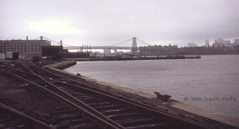
October 1982 - Bulkhead
at foot of North
8th Street looking south
unknown photographer
authors collection
added 03 February 2010
Brooklyn Eastern District Terminal filed the required ICC "Notice of Intent to Abandon Service" on April 8, 1983; and on August 12, 1983, operations at Kent Avenue Yard ceased altogether with the switching of a few covered hoppers at the Bulk Flour Terminal. The operations of New York Dock at Bush Terminal would not fare any better during this same time frame, and after several previous attempts at downsizing; it ceased operations on August 17, 1983.
Joe Roborecky was courteous enough to send me the following image. It is his time book, showing location, assigned locomotive(s), hours of duty and wages. Take particular note of 8/12 (last day of operations at Kent Avenue on locomotive 21) and of the entry for 8/17, with locomotives 22 and 25, and where in the last column is says: "LAST DAY AT NYD".
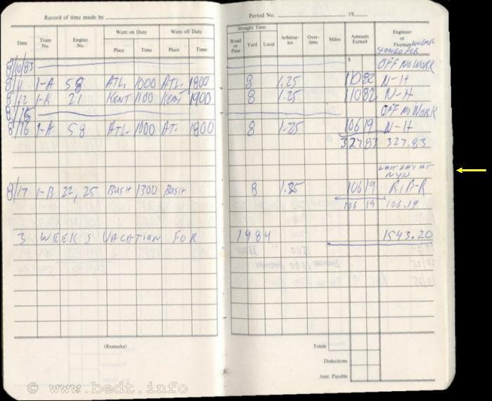
courtesy
of Joseph
Roborecky (R.I.P.)
.
.
According to this Abandonment Appeal (link below),
when this
decision was made by New York Dock to cease operations, it was
decided
upon to abandon the Brooklyn Eastern District Terminal properties
located
at Kent Avenue, but the New York Dock properties located at Bush
Terminal
would be sold to New York Cross Harbor Railroad, even though both
properties
were owned by New York Dock. This is not so difficult to understand
now,
as we know from post 1983 operations, only Bush Terminal would continue
to
operate under New York Cross Harbor ownership, with the Fulton Terminal
of
New York Dock being abandoned as well.
This is not to say the employee's went down with a fight. The following link will take to a copy of the Abandonment Appeal filed in 1984. While there is a lot of legalese and lawyer jargon, there is some pretty interesting information embedded in the chapters:
.
.
|
Eventually the New York Cross Harbor RR, would be organized a week later in August 1983 and would consolidate and NYD & BEDT assets, including several BEDT diesels as well as two tugboats. Some of the locomotives would be put back in service, and would be re-lettered NYCH. The remaining BEDT / NYD locomotives & equipment would be sold off, cannibalized for parts or were outright scrapped. The structures of the main office, the engine house and Bulk Flour Terminal would sit abandoned for many years. They would serve as silent sentinels for an era of marine terminal railroad interchange that has never been rivaled since. Sadly, they too would eventually be demolished. Meanwhile, BEDT #16 sat forlornly on Kent Avenue, with her brass and bronze parts being scavenged. #16 would sit there; first on a siding towards the water, then eventually placed on a concrete pad on Kent Avenue. It would be over 10 years later, before she was finally rescued by Robert Diamond of the Brooklyn Historic Railway Association. #16 would be brought to the New York Cross Harbor enginehouse on First Avenue (Brooklyn), worked on and cosmetically restored. A few years later, after some contentiousness between Mr. Doamond and New York Cross Harbor RR; #16 was then donated to the Railroad Museum of Long Island in Riverhead, NY; where she remains today, and kept in good cosmetic condition. And what has become of the Kent Avenue yards? Through the late 1980's, the rails were taken up and the crossties resold, and for over 15 years the land remained vacant. In July 2006, I had the opportunity to visit the BEDT stomping grounds. Sadly, nothing remains now; save for two sets of track about 100 feet long set in concrete on North 9th Street and Kent Avenue (site of the Bulk Flour Terminal), and a paved over spur to a building. Even Kent Avenue has been torn up, right down to sub-roadbed, and is being repaved, so all street crossing tracks have been torn out. |
|
Signs posted
along Kent Avenue state the
property is a park under construction and is heavily fenced off.
The Austin Nichols
building was
listed as a landmark,
but recently had that landmark status removed, but the
structure has
been preserved and the windows appear to have been replaced; and the
Domino
sugar refinery is no longer making the sweet stuff for coffee.
|
|
..... |
|
East River / Marsha P. Johnson State
Park
Present tense: There is a great land boom developing in the Williamsburg neighborhood, and the land that once was an industrial area and railyard is now home to a residential building boom. Not a bad idea considering the gorgeous views of the East River and Manhattan skyline! A portion of the site of the former BEDT yards Between North 8th and North 9th Streets is now the "East River State Park", and the remainder of the property south of this location is a housing complex. Its name? Palmer's Docks! (Dear Lowell: we've come full circle...)
I have been fortunate to have assisted with the development of this park at the request of Ms. Audrey Nieson of the New York State Office of Parks Recreation & Historical Preservation, Bureau of Historic Sites; in helping create, proof & correct historical information on the interpretative displays located in the park, as well as coordinating usage permission from those current owners of the images chosen to be incorporated in those displays.
The following is an excerpt from the New York State Office of Parks Recreation & Historical Preservation website:
[The] East River State Park is a seven-acre waterfront park located along the East River in the Williamsburg neighborhood of Brooklyn. It offers visitors a stunning view of the Manhattan skyline, a delightful play area, and the green space provides many opportunities for recreation and relaxation. As the site of a 19th century shipping dock, visitors to East River may also discover unique historical remnants like old cobblestone streets and railroad tracks embedded in concrete. Historic interpretive signs are provided for your convenience. The park preserves and protects the many natural and historical resources along this beautiful city waterfront. The park is free and open to the public.
In addition to the great views of the East River and Manhattan, the park offers native meadow plantings among the historic rail yard remnants; passive recreation; picnicking and barbecues.
As
time marches on, I am seeing more and
more residents from the ongoing "renaissance" of the Williamsburg
neighborhood
making their way to this site. Most are just people who have moved to
the
area and wish to learn more about the history of the area they now live
in,
and leave comments in the Guestbook. On 13 December 2011, I had the
pleasure
of posting a "new" image taken of the former BEDT property from a very
unique
vantage point. This image was generously submitted by Nate Able, a
resident
of the residential complex that now overlooks the
East
River State
Park (former BEDT 8A Yard).
...
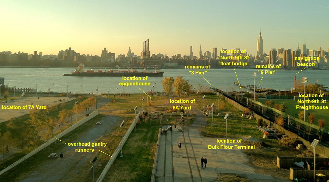
East River / Marsha P. Johnson State Park (former BEDT 8A Yard) - November 12, 2011
Click on image above for annotated
version.
N. Able photo
Thanks Nate!
.
|
Trailer on Flat Car Ramp........ |
|
| Copper | Customer List - Outbound |
.
Palmer's Docks, and likewise the East River Terminal and Brooklyn Eastern District Terminal that followed was in the business of transporting freight to and from it various customers. It is impossible to list every single type of freight that the BEDT transported over it's history. What I have been able to do is recreate a "customer list" from the various newspaper articles, lawsuits, documents, receipts and photographs that I have encountered over the years.
By 1940, the BEDT would become a common carrier, and through the years until its cessation of operations; the BEDT served many large local businesses. The table below lists the customers (where known) of Palmer's Dock, East River Terminal and Brooklyn Eastern District Terminal; 1870-1983. If you happen to be aware of a business that I missed, please feel free to submit it with it's commodity and location for listing.
One thing readers should take note of is, according to the Coverdale & Colpitts Report, carfloated freight car traffic did not go directly from the trunk line / class 1 mainline railroads to Pidgeon Street, Brooklyn Navy Yard team tracks or the "Direct from Carfloat" merchants. Instead, all freight cars were first carfloated to Kent Avenue first, where they would be sorted. Then, those cars destined for Pidgeon Street were then placed aboard a carfloat destined specifically for Pidgeon Street.
It seems odd that BEDT would want to handle the freight cars more times than necessary, but according to this report, this was the method used. Matter of fact, the Coverdale & Colpitts Report suggests revising this method to direct placement to both save the finances involved in the double handling and double move and to ease congestion in the Kent Avenue Yards.
It is understood this was done because it was more financially beneficial for BEDT crews to sort the cars at their home terminal on Kent Avenue, rather than pay the other Class 1 railroad in New Jersey to do so.
.
..
Railroad
Connections & Traffic
Proportions
The
Coverdale
& Colpitts Report
gives a precise breakdown
of the trunk line / class 1 railroads and the respective proportion of
freight
traffic the Brooklyn Eastern District Terminal received from those
railroads.
|
railroad |
connecting point |
% of traffic1935-1939 |
% of traffic1955 |
| Lehigh Valley Central RR of New Jersey Delaware, Lackawanna & Western Pennsylvania New York Central Erie Baltimore & Ohio New York, New Haven & Hartford New York, Ontario & Western |
Jersey City Jersey City Hoboken Greenville Weehawken Hoboken Jersey City Oak Point Weehawken |
15.4 % 14.2 10.8 22.2 14.8 8.4 6.2 7.1 0.9 |
18.1 % 17.7 16.2 15.1 11.5 9.3 5.9 4.9 1.3 |
.
..
.
One of the original reasons behind the creation of Palmer's Dock, would be to transport the raw sugar into Brooklyn for the sugar refineries, as well as ship the finished product out. The East River Terminal and likewise the Brooklyn Eastern District Terminal would follow suit as well in this assignment. American Sugar Refiners was located at Kent Avenue and the other refiner being New York Sugar Refiners at Pidgeon Street. The Pidgeon Street refinery would become Jack Frost brand in the later years.
The Havemeyer's constructed their main refinery in 1859 on South 4th Street. Eventually the property south would be purchased, and added. By reviewing the 1886 E. Belcher Hyde map, one can see the Williamsburg area in the vicinity of Palmer's Dock also still held quite a few sugar refineries. One would be located between North 3rd and North 4th, another between North 6th and North 7th Streets. Many more independent refineries would exist prior to this.
Upon the consolidation of those refiners by the Havemeyer's, the main refinery Havemeyer & Elder sugar refinery located by South 3rd Street, would become the sole refinery in the area. However, this refinery did suffer at least two catastrophic fires, one on January 9,1882 and another on June 12, 1887. This refinery at South 3rd would be completely rebuilt and expanded to South 1st Street in 1926.
Both images below, were taken by the author on July 12, 2008 from onboard the Lehigh Valley Railroad tugboat "Cornell".
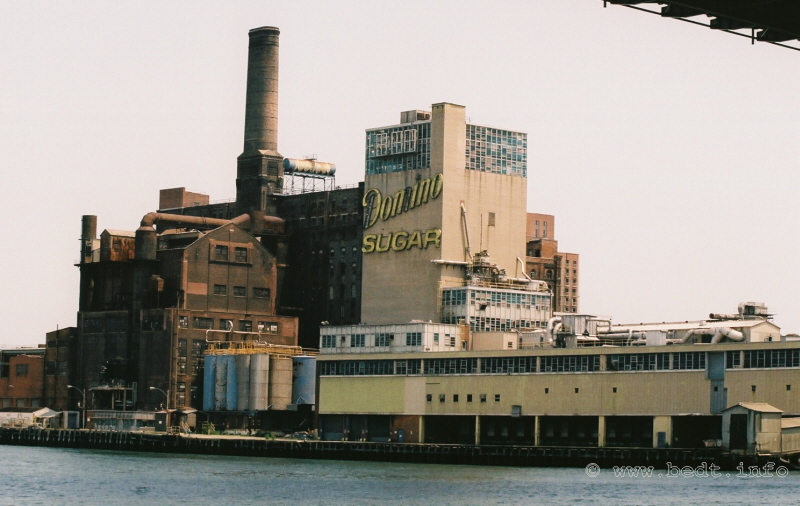
Havemeyer & Elder / American Sugar Refinery (brick /
left - ca.
1887?)
Amstar (Domino) Sugar addition (concrete / right - ca. 1926)
July 12, 2008 - South 3rd Street, Brooklyn, NY
Looking northeast from East River
photo by author
added 30 May 2009
.
.
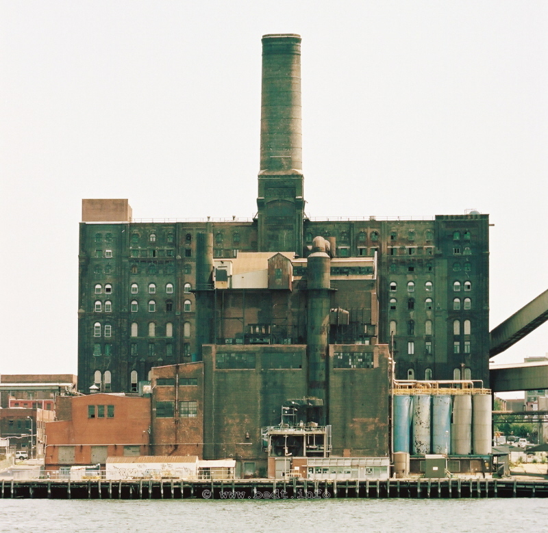
Havemeyer & Elder / American Sugar Refinery (1887?) -
July 12,
2008 - South 3rd Street, Brooklyn, NY
Looking east from East River.
photo by author
added
30
May
2009
.
.
|
Not only was the sugar brought into Brooklyn via Brooklyn Eastern District Terminal, but flour was also transported and stored as well. The Brooklyn Eastern District Terminal once maintained 10 flour terminals with a combined capacity of 450 carloads. Commercial bread bakers of the time, such as Pechter's and others; as well as macaroni manufacturers in the area would draw off the flour from these terminals in truck loads on an as need basis. Eventually Brooklyn Eastern District Terminal would construct the Bulk Flour Terminal for consolidating the specific storage of flour and semolina. The Bulk Flour Terminal would open on March 24, 1964, and cost $300,000 to construct. The Bulk Flour Terminal was constructed by the John Post Construction Corp, of Christopher Street, and the internal flour handling equipment was installed by the General Contract & Shick-Tube Veyor Co of Kansas City, MO. Flour would be pumped out of the hopper means of a removable cart that was placed under the hopper chutes. An image of this cart can be seen in the Joe Roborecky chapter on the Memoirs Page. |
|
.
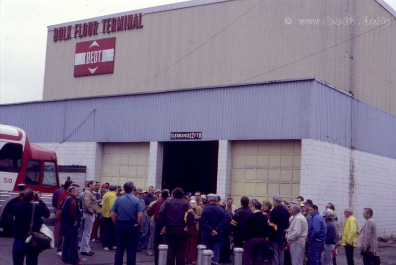
East (Kent Avenue) wall of Bulk Flour Terminal - October 1982
Appears to be a fan trip.
unknown photographer
authors collection
added 13 June 2010
.
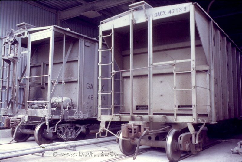
Covered hoppers inside the Bulk Flour Terminal- October 1982
(looking southwest with Kent Avenue behind photographer)
unknown photographer
authors collection
added 13
June 2010
.
.
.
.
Breweries, Beverages
& Distributors
Breweries
Other commodities being received, were carloads of hops for the Liebmann brewery (located in Brooklyn) and the Pabst brewery (located in Long Island), and these arrived via Brooklyn Eastern District Terminal. Hops and malted barley was off loaded at the terminal then hauled by truck to their respective destinations.
The Schaefer Brewery however, which having been serviced by the Lehigh Valley Railroad until 1975, would become a Brooklyn Eastern District Terminal customer that year. The Schaefer Brewery was located directly on the East River immediately north of the Brooklyn Navy Yard and Wallabout Canal. Schaefer was also a unique customer in the fact that it was a "direct from carfloat" customer.
Specially modified carfloats, known as "centerpipe" carfloats, were utilized with pneumatics in offloading the bulk material (hops, barley) held in covered hoppers aboard the carfloat.
This photos, found in July 2026; is within the Digital Collection of the New York Municipal Archives, and uncropped it contained a oblique aerial image of the South Williamsburg / Brooklyn Navy Yard vicinity. I have cropped it somewhat for the pertinent subject of this chapter. In the image, dated May 17, 1967; one can clearly see the Lehigh Valley "centerpipe carfloat" with hose attached along the bulkhead of the Schaefer Brewery. As the hose is attached to the rear of the carfloat, I can say with 100% certainty, that that is the Lehigh Valley carfloat (as BEDT's versions of the centerpipe were much longer, and had the hose connection and platform more towards the center of the carfloat. You can click on the image below for a larger, higher resolution image.
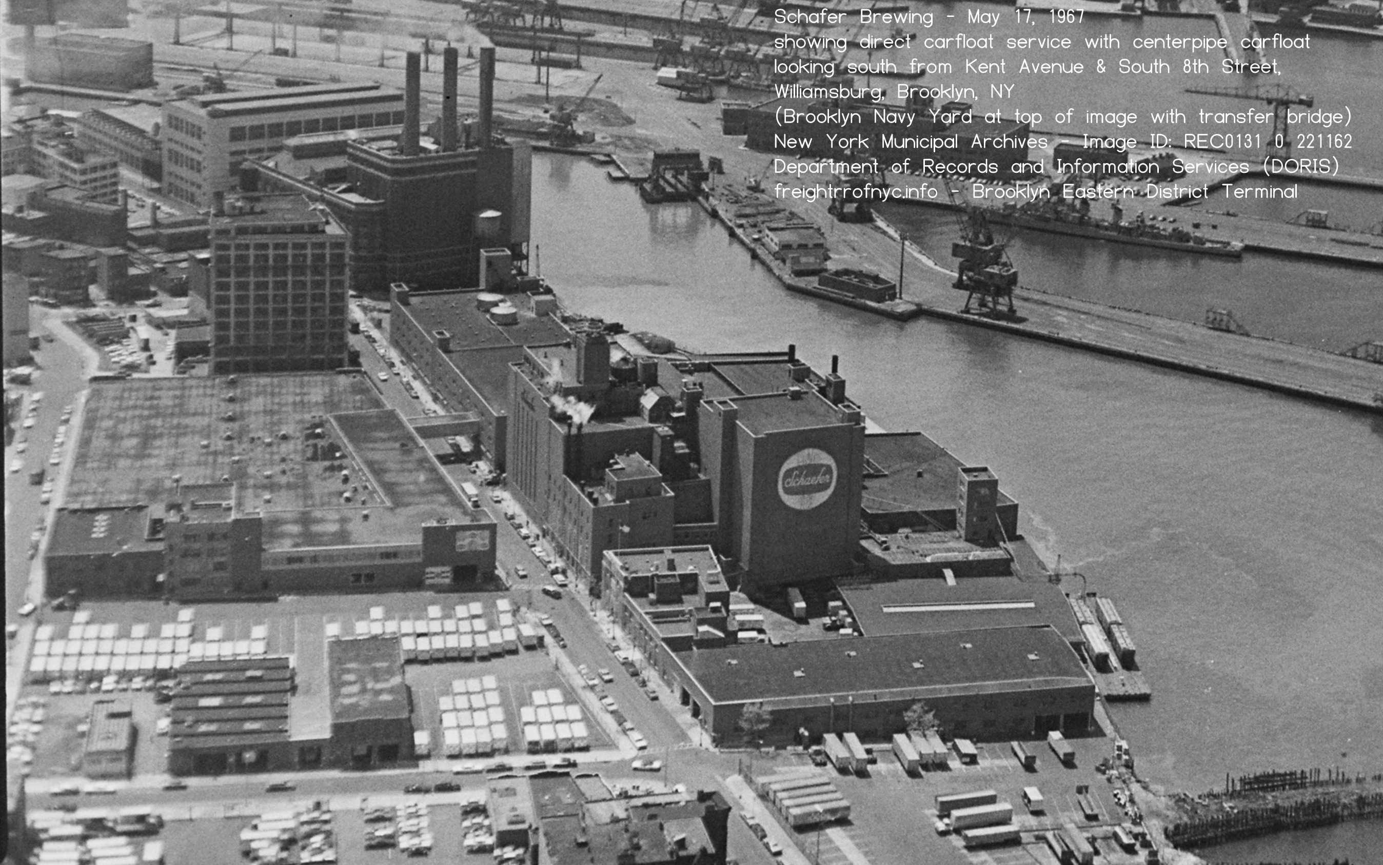
In this image, taken by Tom Flagg, we see a side view of the Lehigh Valley centerpipe carfloat at the Schaefer Brewery bulkhead.
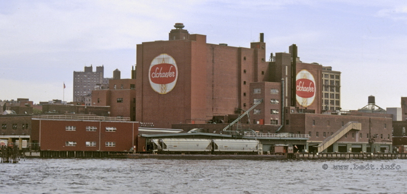
Schaefer Brewery
& Lehigh
Valley "centerpipe" carfloat
- September 1972
courtesy of T. Flagg
added 19 February 2010
.
At some point in its history, Schaefer Brewery became this direct from carfloat customer of the Lehigh Valley Railroad, although the exact date eludes us. As a result, the Lehigh Valley Railroad modified a carfloat into a centerpipe type. (More about this later.) In 1971, Schaefer decided to build a new brewery just outside of Allentown, Pa. The following excerpt is from "Breweries of Brooklyn", by Will Anderson; 1976:
Schaefer's most dramatic move with respect to plants was the decision, in 1971, to build a brand new, ultra-modern brewery just outside of Allentown, Pa. Realizing that all three of its plants at the time, Brooklyn, Albany, and Baltimore, were old and inefficient, Schaefer management decided it had to go the route being taken by Pabst, Schlitz, Anheuser-Busch and Miller - build a brand new and thoroughly modernized brewery rather than continue to try to upgrade old facilities. To construct a new brewery is extremely expensive, of course, but when it was opened in 1972 Schaefer could be justifiably proud - their Lehigh Valley plant was one of the most modern and efficient breweries in the world!
What does a company do, however, when it has one ultra-modern plant and three that appear very dated by comparison? The question is really rhetorical, of course; strive to add to the modern plant while phasing out the less efficient facilities. And that's exactly what Schaefer did. The Albany plant was shut down almost immediately, on December 31st of 1972. In 1974 the Lehigh Valley plant was expanded from its original 1,100,000 barrels-per-year capacity to 2,500,000 and then, in 1975, it was decided to expand again - to 5,000,000 barrels plus. By 1975, therefore, it was obvious that one of the two less efficient plants should and would be closed, the only questions remaining was which plant, Brooklyn or Baltimore, and when. Both questions were answered on January 22, 1976 when Robert W. Lear, Chairman and Chief Executive Officer of The F. & M. Schaefer Corp., announced the closing of the Brooklyn plant.
Apparently, when the Lehigh Valley Railroad
learned of Schaefers'
impending closing of the Brooklyn plant, Lehigh Valley dropped Schaefer
as
a customer before Schaefer actually closed, leaving the Schaefer
Brewery
without rail / carfloat service. Exactly why Lehigh Valley chose to do
this, is
currently
unknown.
As a result, the Brooklyn Eastern District Terminal stepped in and offered direct carfloat service for Schaefer's remaining tenure in Brooklyn. Improving upon Lehigh Valley's lead, the BEDT converted one of their platform / station type carfloats into a "centerpipe" carfloat as well, to be used for Schaefer Brewery unloading. Brooklyn Eastern District Terminal carfloat #26 would be selected for this conversion.
As it also happened, BEDT #26 was longer than the Lehigh Valley centerpipe carfloat and allowed for a greater car capacity. This would allow the Brooklyn Eastern District Terminal to reduce the number of times the centerpipe carfloat would need to be transported to and from Schaefer and the BEDT float bridges, and thereby reducing the number of times in having the freight cars swapped out on those centerpipe carfloats.
Brooklyn Eastern District Terminal also purchased a surplussed platform / station carfloat from the Pennsylvania RR (carfloat #588), and converted that carfloat to a centerpipe as well. Brooklyn Eastern District Terminal numbered this carfloat to BEDT #32. Images of both the #26 and #32 carfloats can be seen on the Marine Equipment page.
It should be noted that the center platforms removed from the carfloats would not go to waste either, and would be placed parallel to trackage so that trucks could backup to the platform and freight transferred from boxcars directly into the trucks. The platform from BEDT carfloat #26 was placed at North 9th Street, and the platform from Pennsylvania RR carfloat #588 was placed at Pidgeon Street.
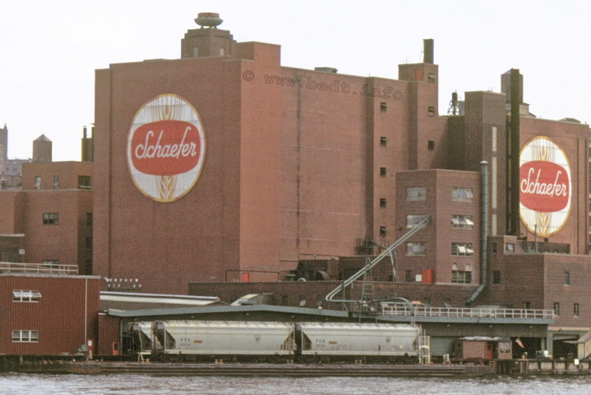
September 1972 - Stern
of carfloat to right of image.
T. Flagg photo
|
Many industries utilize pneumatic unloading, but this method allowed the covered hoppers to be unloaded pneumatically while still on the carfloat. At the Schaefer Brewery, an A frame held a pair of hinged rigid wall suction pipes, which hung over the bulkhead. When the carfloat needed to be moved, the pipes would swing up and out of the way. On the carfloat itself, the horizontal deck pipes made a 90 degree turn upward at the elevated platform, with the vertical pipe terminating just above the top of that platform. There were two deck pipes, one for each track. When the carfloat arrived and was moored, these hinged pipes would be lowered to and connected from the brewery to the vertical pipe on the carfloat. At deckpipe level, the deckpipe had capped couplings every 10 feet or so. Short sections of rigid wall hose would connect the individual hoppers to the coupling on the deckpipe, and after a vent hatch was opened, the materials within the covered hopper would be siphoned off. According to Joe Roborecky, not all cars were hooked up to the deckpipe at same time. When all the hopper cars on the carfloat were empty, that carfloat would be exchanged for one carrying full covered hoppers. In the image above and to the right, the Lehigh Valley carfloat is shown at Schaefer bulkhead. The graphic below denotes the distinguishing characteristics of the three carfloats. In
all actuality, the BEDT centerpipe carfloats were not in use long,
seeing how BEDT picked up Schaefer Brewery as a customer in 1975 and Schaefer
closed its Brooklyn plant towards the end of 1976 or early 1977. |
|
It leaves one to wonder even why BEDT would go through the expense of converting those carfloats for such a short duration, knowing Schaefer was closing the plant and leaving the New York area. Unless of course BEDT was hedging a bet on a last minute reprieve of Schaefers' decision to close the plant, and it would stay open. But, as we all know now, Schaefer closed the plant.
In November 2011, and once again due to
the keen eyes of Paul Strubeck; we have determined that there were in
fact
at least three centerpipe carfloats: BEDT #26, BEDT
#32 and one built
by the Lehigh Valley. (I originally concluded, erroneously I might add,
that
BEDT 32 was the Lehigh Valley carfloat). These three carfloats can be
easily
distinguished from each other:
BEDT #26 and #32 were longer (six 50'+ car capacity as having been modified from a station type carfloat) than that of the shorter Lehigh Valley carfloat.
BEDT #26 had Hayes style track bumpers, #32 had box style track bumpers painted yellow. The Lehigh Valley centerpipe carfloat had brown box style track bumpers.
BEDT #26 had mooring cleats, BEDT #32 had mooring cleats along the sides with button bitts on bow & stern, and the Lehigh Valley had double bitts along the sides.
On
BEDT #26 and #32, the deckpipe platform was offset from the end with a
segment of deckpipe to the rear of the platform, while the Lehigh
Valley with the deckpipe
platform at the extreme rear end of the
carfloat and at the end of the deckpipe.
The sides of the Lehigh Valley carfloat also incorporate three rub rails which take on the appearance of corrugation while the BEDT carfloats did not.
BEDT #26 & #32 had mooring cleats along the top edges of the carfloat deck, and the Lehigh Valley carfloat had double bitts.

.
What eventually happened to BEDT #26, we do not know. BEDT #32 was seen in several images from 1976 through 1983. The Lehigh Valley centerpipe carfloat also disappeared without a trace.
.
..
Beverage
Distributor
Brooklyn Eastern District Terminal also serviced a large beer distributor in Long Island City via the Pidgeon Street yard. According to Joe Roborecky, it was not a brewery as originally thought, but a distributor that would primarily receive Miller Beer products via boxcar. It is unknown at this time if it received other brands as well. Boxcars of already manufactured and filled containers would be delivered to this location.
In this arrangement, Brooklyn Eastern District Terminal would switch and spot the boxcar(s) containing the appropriate size containers by the various receiving docks. As there were many types and sizes of beverages being delivered at that time, the boxcar they needed might have been several cars up track and not near the receiving dock. So Brooklyn Eastern District Terminal crews would have to rearrange or "spot" the boxcars to place the appropriate boxcar by the appropriate receiving dock.
Pepsi
Cola
Also located at the Pidgeon Street Yard was a Pepsi Cola bottling plant. According to the Pepsi Cola Bottling website, this Long Island City location was the original Pepsi bottling site until 1934, when other Pepsi bottling plants would open around the United States. I particularly recall seeing the huge neon "Pepsi-Cola" sign which could be seen from most East Side locations in Manhattan, especially from the FDR Drive. I believe this sign still exists as a landmark.
Exact details of the Pepsi plant and the interaction with the BEDT are unfortunately not known at this time, but it is understood from the Coverdale & Colpitts Report, that the Pepsi Cola Bottling Plant was a "Direct From Carfloat" customer and yet it is understood from Tom Hendrickson that there was indeed some sort of rail traffic with the Pepsi plant.
It can only be hypothesized that this Pepsi bottling plant received tank cars of corn syrup, cola syrup, and possibly carbon dioxide for carbonation; as well as bottles, cans and cardboard for boxing and packaging.
It is unknown at this time if the Pepsi plant utilized team tracks or sidings in addition to the direct from carfloat traffic.
.
.
.
Another of the original commodities received via Palmer's Dock and subsequently East River Terminal Railroad / Brooklyn Eastern District Terminal, was grain.
Grain is a rather generic term, as listed in the 1920 Joint Report with Comprehensive Plan & Recommendations, issued by the New York, New Jersey Port & Harbor Development Commission) "grain" pertains to Wheat, Corn, Oats, Rye, Barley, Buckwheat & Flaxseed. Which of, or what combination of those grains was actually stored by Brooklyn Elevator & Milling, is not clear at this time, but this "grain" would be held in the multi-story elevator (similar in principal to a silo) of Brooklyn Elevator and Milling located on the East River bulkhead between at North 9th and 10th Streets.
While it is clearly known that Lowell Palmer created the "Palmer's Dock Hay & Produce Board", it is unknown if Palmer was actually involved in the early stages of the Brooklyn Elevator & Milling. The 1893 Brooklyn Daily Eagle Almanac, states:
"the Brooklyn Elevator Hay & Produce Exchange occupies a new and commodious building at the foot of North Tenth st. [sic] It is the principal market of the kind in the city, and is largely patronized by merchants in N. Y. City"
Later documents (post 1900) reflect that the Havemeyer family were the principals of the Brooklyn Elevator & Milling, with Henry, Theodore, Frederick, Horace all holding various positions on the board of directors.
The exact circumstances regarding the receipt and handling of this "grain" by Brooklyn Elevator & Milling is uncertain. Almost every grain type on the list above could have been used by one merchant or another in Brooklyn (Wheat, Corn, Rye for bread & baking, Oats for horse feed, Hops & Barley for brewing, etc).
Various documents located via Google
book search show various grains could be found at Brooklyn Elevator
&
Milling:
.
1906: Sample of ground feed taken from Brooklyn Elevator & Milling for chemical analysis.
1922: Lawsuit filed in
January
against Brooklyn Elevator & Milling states 18,000 ducks were
lost by the quality of bran sold.
As horse drawn
wagons were still the primary
mode of transportation when the elevator was constructed, and taking
into
consideration that oats were used for livestock / horse feed; and that
the
North 10th Street Hay Storage Building (the low three story brick
structure
with the arched windows seen behind the silos in the image below)
abutted
directly against the Elevator & Mill structure, leads to the
possibility
that the storage of feed in the Brooklyn Elevator &
Mill took place
for the many stables in the Williamsburg area. As this structure would
disappear
from view and aerial maps by 1924. Oddly, this coincides with the
advent
and expansion of the internal combustion driven trucks.
New York Times archives show that on November 25, 1912, an explosion and subsequent fire destroyed the plant of the Union Sulphur Company. Thirty-four persons were injured. Flying embers set fire to the hay market on the opposite side (south side) of North 10th Street. In a statement issued to the New York Times by H. O. Havemeyer, $245,000 worth of damage was done to the Union Sulphur Works, which was insured for $375,000, as well as undisclosed amounts of damage upon the hay market. The upper two floors of the grain elevator were also heavily damaged.
Therefore, two possibilities exist pertaining
to the Brooklyn Elevator & Mill structure seen in the below
image:
This image was taken prior to the fire and subsequent damage, or
These structures were
rebuilt.
In any event,
whatever "grain" this elevator
would have been used for, this elevator had a listed capacity
of 500,000
bushels and can be seen in the 1914 image below, contributed by Tom
Flagg.
If one looks carefully, the faded remains of the painted "Brooklyn
Elevator
& Milling Co." can be seen on the side wall of
elevators (to the
right of the smokestack).
There is a service track internal to the structure, and boxcar can be seen partially inside the structure (next to the double row of windows on the ground floor).
As mentioned above, this structure would be razed by 1924, (as the elevators are no longer seen in the Fairchild Aerial Photo taken that year) and when significant portions of the property was reconstructed.
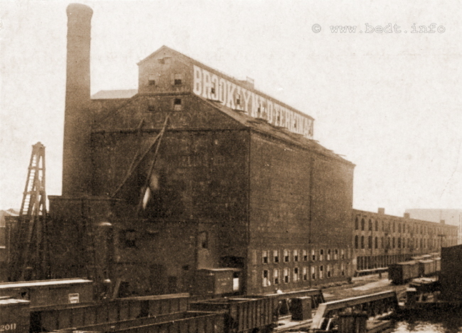
Brooklyn Elevator & Milling - circa 1914
Between North 9th and North 10th Streets, looking east.
courtesy of Thomas Flagg
added 29 May 2009
.
.
.
As previously mentioned in the Palmer's Dock
History, Palmer
consolidated the coal sheds in Williamsburg and opened his own
wholesale
coal depot: Palmer's Coal Depot.
In the later years of Brooklyn Eastern District Terminal operations; a set of yard tracks would dedicated to the receiving and off loading of coal when this coal depot was removed from service. This set of yard tracks was located in the North 7th Street yard and hopper cars loaded with coal would be brought in by BEDT and placed in the yard. Portable wheeled conveyors would then be placed under the unloading chutes of the hopper car. The coal was offloaded out of the hopper, onto the conveyors, and directly up and into the retailers trucks using this method. A picture of the hoppers and the conveyors, with a coal dealers truck can be viewed on the BEDT Properties Page. So in all essence, the hopper cars itself (and not the typical coal silo) were the storage as well as shipping methods.
Coal was a primary commodity of the Brooklyn Eastern District Terminal until the use of coal declined as a fuel in the early to mid 1950's, where it was dropped in favor of fuel oil and natural gas. Some of coal dealers receiving coal via the Brooklyn Eastern District Terminal was the Berry Coal Company< Bacon Coal Company and the Scranton & Lehigh Coal Company.
The Scranton & Lehigh Coal Company, would have rather large concrete coal silos located on North 5th Street, between Wythe Avenue & Berry Street.
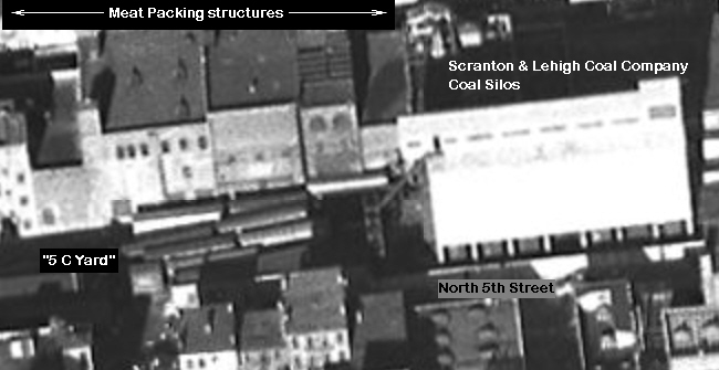
NYSPL
/ NYS Archives
Digital
Collection
.
Note the address of the main offices in the newspaper advertisement below: 84-86-88 Kent Avenue - the same as the administerial offices of the Brooklyn Eastern District Terminal! However, the president of Scranton - Lehigh Coal Company; Thomas Patterson; has not been encountered before as an employee of the Brooklyn Eastern District Terminal.
Therefore did BEDT lease space to Scranton & Lehigh, or was it a wholly owned subsidiary of the BEDT?
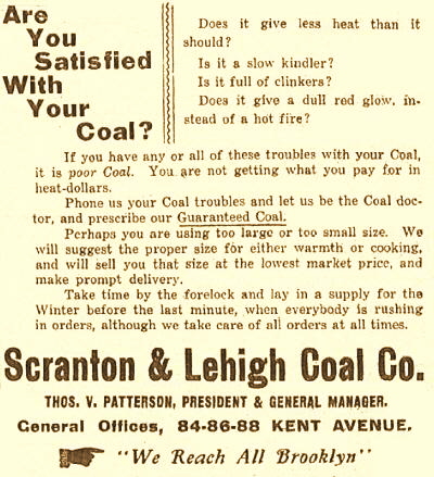
.
.
Bacon Coal (as seen from an advertising card shown below), had a location that was specifically serviced by the Brooklyn Eastern District Terminal: "Newtown Creek / Wallabout Canal". Notice the date on the card: 192_.
This date raises an interesting question as all information to date reflects that the Brooklyn Eastern District Terminal did not take up occupancy in the Wallabout Canal area until circa 1933. So, was the Brooklyn Eastern District Terminal providing service to this area earlier than believed, or was this a bulkhead delivery only facility?
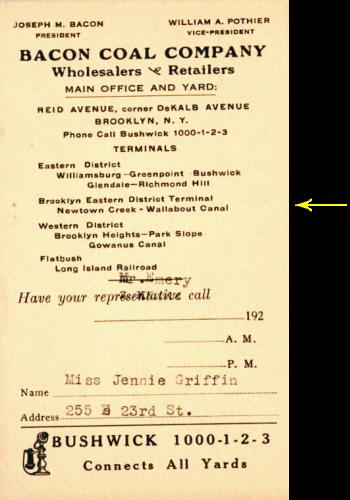
.
.
Throughout the decades when they would be located
in Williamsburg,
Brooklyn; the Armour, Cudahy, Morrell and Wilson meat packing companies
would
receive countless tons of beef daily via Palmer's
Dock, East River
Terminal and subsequently the Brooklyn Eastern District Terminal. There
was
also the firm of Moore Trucking, which was a meat distributor
throughout
western Long Island.
At peak times, it was not uncommon for 50 carloads (that's fifty boxcars of 40 ton capacity equaling 4,000,000 pounds of meat); to be received by the Brooklyn Eastern District Terminal for dispatch on a single Monday. Those 50 cars were roughly the occupancy equivalent of two and a half carfloats.
These meat packers were located on the south side of North 6th Street, and stretched almost the entire length of the block between Wythe Avenue and Berry Street. While the "store fronts" of these meat packers faced north on North 6th Street, a track was located along the back (south side) of the buildings which opened upon the North 5th Street "C Yard" for the unloading of meat into the respective packing houses.
Generally speaking, the multi-track yard at this location occupied the almost the entire length and half the width of the block bounded by North 5 and North 6th Streets, Wythe Avenue and Berry Street.
The inset below, taken and modified from the Belcher & Hyde map of 1929; shows the relative arrangement of the "C Yard" trackage for that era. It is unclear if the trackage ever extended to Greenberg Brothers. Iron & Steel, and it is not known how extensively the track arrangement would change when the coal bunker was torn down many years later.
.
.
This commodity would diminish and eventually cease at the Brooklyn Eastern District Terminal, as these Brooklyn based meat packers would either relocate out of Brooklyn throughout the 1960's and 1970's to the Hunts Point Terminal Market, or simply shutter their door altogether.
Like those slaughterhouses and meat packers located on the West Side of Manhattan, the slaughter and subsequent meat processing of livestock was now taking place adjacent to to the growing farms and stockyards of the Midwest and South: Chicago, Omaha, Kansas City and Fort Worth; and with the advent of self-contained mechanical refrigerator cars.
It was no longer necessary to keep the livestock alive to their destinations for "freshness."
.
.
.
Another significant commodity of the Brooklyn
Eastern District
Terminal which was ascertained from the
Coverdale
& Colpitts Report,
was cement and lime.
Most, if not all of the cement product was delivered via a team track
at
the Pidgeon Street Yard in Long Island City. Unloading of this product
at
that location was expedited under contract by an independent contractor.
Lime on the other hand was offloaded (at the date of this report) at the Kent Avenue Yard by Charles Pfizer & Co.
Seen in photos dated April 12, 1963 and September 23, 1963 of #14 in the North 9th Street Yard, shows a rather new and clean "six pack" group of tall steel silos. These silos were used for cement storage. Unfortunately, these silos are not reflected in any aerial photos of 1954, 1966 or 1980 on historicaerials.com; or in any of the track maps of 1953 or 1965.
However, Tom Flagg furnished a track map of BEDT dated 1969, and these silos are shown so we at least now know the silos stood from at least 1963 through 1969. The actual dates of construction through removal remain unknown.
|
|
 |
 |
|
April 12, 1963 |
September 23, 1963 |
September 23, 1963 |
.
Unfortunately, this is all that is known about these commodities at this time and further research is both pending and welcomed.
.
.
.
Iron &
Steel - Finished
Products as well as
Scrap
The Brooklyn Eastern District Terminal received its fair
share of
finished iron and steel products. A substantial portion of this
structural steel, was
destined for the Navy Yard for military ship construction, but there
were
quite a few regular civilian customers receiving structural steel at
the
various BEDT Yards for building and possibly highway construction. The
BEDT
was well equipped to handle even the largest loads, and mentioned in
the
Coverdale
& Colpitts Report as
a special "enticement"
to draw customers, BEDT offered to provide free crane service on pieces
weighing
more than 1,000 pounds.
While finished steel held a significant proportion of inbound traffic; scrap iron and steel as well as other metals was a significant outbound commodity. There were a few scrap yards in the industrialized sections of Williamsburg, as well as other parts of Brooklyn. It is understood from images that the BEDT would set aside a few team tracks to facilitate the loading of scrap metal into gondolas.
In several images, an electro-magnet mounted on a crane can be seen. In the 1952 Railroad Magazine article by Melvin Krampf, it states that 35 to 40% of scrap metal originating in Brooklyn is shipped through the BEDT, with 79% of the outbound scrap destined for either Buffalo, NY or Bethlehem, PA. Images accompanying this article shows the yard area assigned for the loading of scrap metal was between North 8th and North 9th Streets by Kent Avenue, to include use of the overhead gantry at this location. According to Joe Roborecky, BEDT also employed the used of tracked "crawler" cranes with electro-magnets to assist in the loading of this scrap metal.
|
|
... |
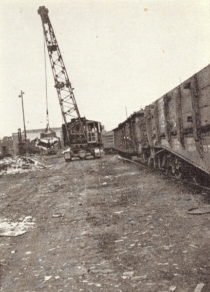 |
| .
. |
||
|
|
||
| .
. |
||
|
|
||
.
Independent Scrap which began operations at their property between North 11th and North 12th Streets, between Kent Avenue and the bulkhead. The image below, located in the New York Municipal Archive; shows the extreme northern portion of the BEDT property so rarely seen.
They would relocate their operation move to the former Pennsylvania Railroad North 4th Street Terminal property about 1966, making this image probably one of if not the last showing this operation at that location. A unannotated version of this image is available if you click on the below image.

North 9th Street through North 12th Streets, west of Kent Avenue
New York Municipal Archives - Image ID: REC 0131 0220758
added 23 July 2026
.
The former PRR property had been purchased by the Brooklyn Eastern District Terminal and on an as yet undetermined date (believed to be 1959), then subsequently leased to Independent Scrap. A few dedicated sidings would be constructed on this property and connected to the BEDT trackage for the receipt of empty gondolas for loading of scrap metal.
Independent Scrap by the way, would receive several contracts to scrap New York City Transit Authority subway cars.
In the image below, the locomotive and gondola is on track 4A7 coming out of Independent Scrap (ex-PRR North 4th Street Freight Station and is crossing the Intersection of North 5th Street and Kent Avenue. Track 5A1 can be seen to right of loco front step and the crossing shanty is on right edge of image.
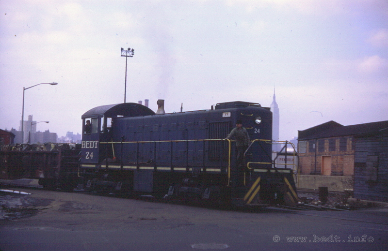
4A7 - January 21, 1968
R. O. Adams photo
authors collection
added 08 February 2011
.
.
.
.
Ben Schaeffer has contributed information that is particular of interest. Following the demise of Baltimore & Ohio Railroad, several pieces of their floating equipment were acquired by New York Dock, and by nature of the 1979 merger with same, were stored at and / or used by Brooklyn Eastern District Terminal.
Two scows, numbered 345 and 350; were acquired from Baltimore & Ohio along with numerous platform / station carfloats, the floating machine shop "James H. Clark" and the tugboat "Roy B. White".
As it would turn out, these scows would be used by the Brooklyn Eastern District Terminal in the transport of copper anodes to the Phelps - Dodge Refining Corporation located on Newtown Creek. The copper was used for for the making of copper sulfate based pesticides.
It is also surmised that BEDT took over this customer from the Long Island Rail Road, as in 1977 the Long Island Island Railroad ceased handling freight via their transfer bridges located at Long Island City. Phelp Dodge had multiple sidings serviced from the Montauk Branch.
For unknown reasons; there was a long
involved, labor intensive process for the transfer of copper
ingots
arriving via the Brooklyn Eastern District Terminal to Phelps -
Dodge:
.
High cube boxcars loaded up to their haulage capacity with 750 pound copper ingots, would arrive at Brooklyn Eastern District Terminal on a three track interchange carfloat.
These boxcars were hauled off the three track interchange carfloats, and transferred onto a modified station / platform carfloat. Joe Roborecky recalls that this station carfloat was so modified, in that the roof of the platform was raised to accommodate the opening of the plug doors on high cube boxcars.
Also, one empty boxcar with a fork lift inside was also loaded onto the station carfloat, with the boxcars loaded with copper.
This carfloat was then moved slightly upriver from the float bridge at North 9th Street to north side of "9 Pier" (slightly north of the float bridge) and moored to the pier.
Then, one of the former B & O scows would be moored against the station carfloat.
Then the fork lift would exit the empty boxcar, and begin removing the copper ingots out of the loaded boxcars and set them down on the carfloat platform.
Now another fork lift (or the same fork lift later in the day) would pick up the anodes of the station carfloat platform and stack them on the scow deck.
When all the boxcars were unloaded and all the ingots on the scow, the scow would be brought to the Phelps - Dodge Smelter located on Newtown Creek to be offloaded.
Fortunately, this operation did not occur every day (and I certainly hope not considering the labor involved!)
And exactly why this laborious procedure was needed is unclear. I can only postulate that perhaps there was bulkhead crane at Phelps - Dodge used to remove the stacks of ingots from the deck of the scow in bulk, but if the ingots were loaded inside boxcars, they could not be accessed by the crane and hence the transfer onto an open scow. Or perhaps demurrage (storage fees charged by the railroads) on the boxcars was more than the labor costs involved in transfer the anodes to an open scow which could then be tied up the Phelps - Dodge bulkhead and left to be unloaded at their convenience. Who knows.. and if you do, send an email to bedt14@aol.com for inclusion here.
We have photographic confirmation of this operation, or at least this service to Phelps - Dodge. Ben Shaeffer has generously provided two photographs showing the ingots on B&O scow #345 at BEDT:
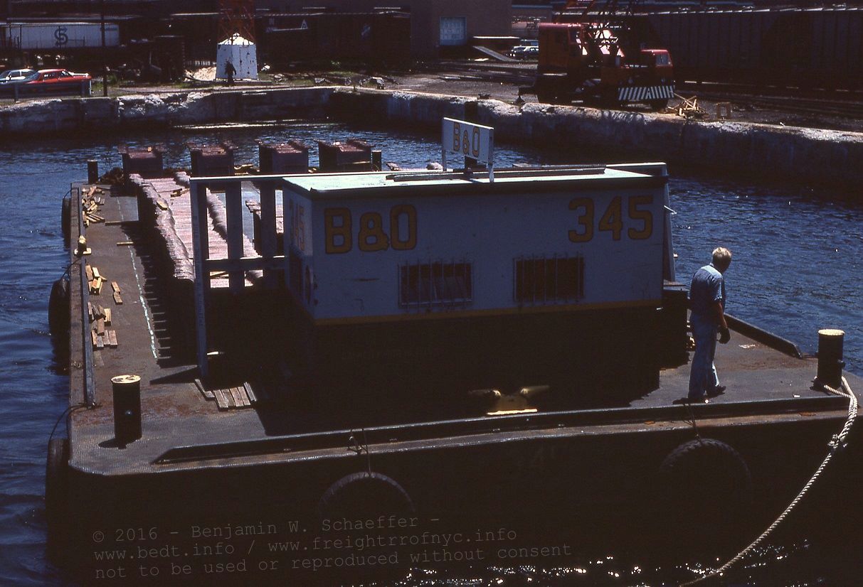
July 12, 1978 - East River at north side of North 9th Street Pier
looking
east.
(Note navigation beacon base in background).
It is unknown if the BEDT road crane was used for this process.
Benjamin W. Schaeffer photo
collection Philip M. Goldstein / Paul F. Strubeck
not
to be used or reproduced without
consent
added 29 October 2016
x
x
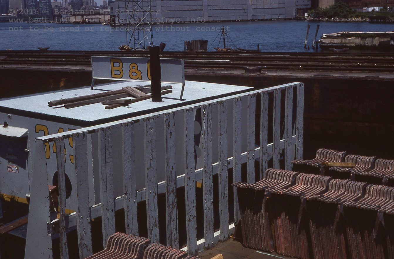
July 12, 1978 - East River at north side of North 9th Street Pier
looking
north.
Note navigation beacon base in background.
It is unknown if the BEDT road crane was used for this process.
Benjamin W. Schaeffer photo
collection of Philip M. Goldstein / Paul F. Strubeck
not to be used or reproduced without
consent
added 29 October 2016
.
.
According to the recollection of Joe
Roborecky; the Brooklyn
Eastern District Terminal was engaged in the transport of baled waste
paper
and cardboard to an unknown location or locations. Joe cannot recall
whether
the baled waste paper was inbound or outbound, but does recall the
bales
being on stake bed trucks being trans-loaded to or from the railroad car.
It is plausible however, before widespread recycling became the choice of todays "ecologically friendly" disposal methods, this baled cardboard and paper products were sent to incinerators for burning.
Please note this is the authors hypothesis based on the prevalent method of the disposal of waste paper in the era of BEDT operations.
.
.
The Austin Nichols Company, was the purveyor of
Sunbeam Foods
label, and was the largest grocery wholesaler of its time. Austin
Nichols
would receive many different foods and edibles through the Brooklyn
Eastern
District Terminal, such as: dried fruits, coffee, cheese, olives and
peanut
butter. In 1934, following the repeal of the Volstead Act
(Prohibition), Austin Nichols entered the liquor business as
well.
The structure was designed by Cass Gilbert (of Woolworth building and Brooklyn Army Terminal fame), financed by Havemeyer & Elder, and was constructed from 1913 to 1915. It had its own pier trackage and had three sidings designed and built into its ground floor at the northwest corner, where the Brooklyn Eastern District Terminal would directly place inside the building whatever cars were destined for Austin Nichols.
The BEDT also installed a float bridge at the foot of North 4th Street; that provided direct freight car service for Austin - Nichols. This float bridge is reflected in maps prior to 1934. Sunken remnants of this float bridge was observed by Joseph Roborecky, in the late 1960's when he began employment with BEDT.
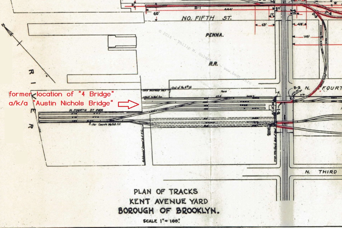
The railroad tracks would enter the building at the foot of the pier and ran inside the entire length of the building (paralleling North 4th Street). The indoor tracks had an elaborate system of trackside conveyors to move freight throughout the building The tracks then exited the east face of the structure at, and crossed Kent Avenue, where they would continue east to Wythe Avenue and join back up with another track, forming a runaround.
After Austin, Nichols & Company's closed other locations due to downsizing, the Williamsburg warehouse was used solely for importing and manufacturing products for the company. Austin, Nichols & Company's lease was renewed in 1934, and a distillery was subsequently installed. After this, circa late 1938, the grocery business was sold off to Francis H. Leggett & Co. and Austin Nichols focused exclusively on liquor sales.Federal Business Machine took up occupancy in the structure, the Brooklyn Eastern District Terminal would continue to service the new tenant. The intervening three decades would see several tenants come and go. BEDT filed for bankruptcy and ceased operations in 1983; effectively ending any and all rail service to the location.
The warehouse, was purchased in 1986 by until 184 Kent Avenue Associates. The Austin Nichols building, in part due to its design by Cass Gilbert, recieved landmark status, but was subsequently taken off the list. After a court battle, landmark status was restored.
As of July 2008, portions of the roof of the Austin Nichols building were removed, leaving the four walls; with the intent of being converted into luxury condominiums. In the image below, you can see the remains of the three track entrance in the bottom left of the structure (immediately to the right of where the yellow loader is parked). A new concrete pier was built almost but not quite in the same location original track pier (as you can see, the right track bay would open onto the water now).
With renovations completed, the structure is now residential, which includes 338 luxury condominium apartments, ranging from studio apartments to three-bedroom suites. There is also 17,850 square feet of rentable commercial space on the first floor. A cafe area and enclosed courtyard are located within the building and indoor garden. Other residential amenities include a musicians' room, a movie room, a riverfront gym, a children's play space, and shared rooftop space.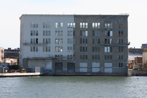
Former Austin Nichols Building under renovation - July 2008
P. F.
Strubeck photo
.
.
.
The Brooklyn Eastern District Terminal also
provided a unique
service to several customers.
It would place carfloats loaded with cars at specific locations for the direct offloading of the customers product at their facility without the need to offload the cars themselves. This was known as "direct from carfloat" service.
The carfloats, usually station carfloats (with a platform in place of the center track as seen on interchange carfloats) would be moored directly to the bulkhead of the customers property or at pier leased from the City of New York. Employees of the company at their location, would then remove the cargo directly from freight cars aboard the carfloat.
Several customers throughout the history
of the Brooklyn Eastern District Terminal would take advantage
of this unique service. Since only a few customers were
occupying bulkhead
properties,
there were not many who could exercise this option. So far, these are
the
customers known to have received direct from carfloat
freight:
.
|
Gas Purifying Materials |
unknown petroleum products soft drinks petroleum product copper chemicals sugar hops, barley, yeast |
.
While this
direct carfloat service eliminated
the need for the construction of a float bridge, team yard trackage and
the
maintenance of same; this service would require the Brooklyn Eastern
District
Terminal to occupy and logistically take out of service one or more of
its
car floats for a duration of time.
.
.
.
One can just imagine what freight and military supplies moved through the Brooklyn Navy Yard facility.
The Brooklyn Navy Yard would have its own steam locomotives during WW1 and in later years "fireless" steam powered and Diesel-electric locomotives until the conclusion of WWII. This location is covered in depth on my companion website: Military Railroads of the New York Metropolitan Area: Brooklyn Navy Yard
The following image shows a ships propeller
arriving at the Brooklyn Navy Yard in 1942. This shipment would have
been
transported to the Brooklyn Navy Yard by the Brooklyn Eastern District
Terminal
at this point in time.
How the BEDT came to serve the Brooklyn Navy Yard,
is covered in depth in the chapter: Wallabout
Terminal
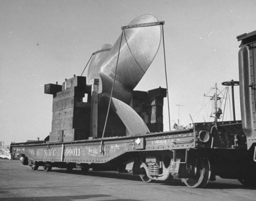
1942
George Strock photo
Life Magazine archives (also South Street Seaport
Museum)
added 20 Nov 2008
.
Throughout the years, one of the largest commodities being shipped to the Navy Yard were hoppers loaded with coal for the powerplant there. According to Joe Roborecky, BEDT locomotive engineer (1968 -1983), if there was a carfloat with hoppers and a locomotive on it, it was going to or coming from the Navy Yard. Loaded coal hoppers would be brought to the Powerhouse and unloaded almost immediately. Then the empties would be brought back to the carfloat and loaded.
When necessary, hopper cars would be stored on lead tracks running up to the Powerhouse within the Navy Yard and BEDT would handle the movements. The hoppers would be spotted with the chutes over an unloading pit, and the coal dumped. Portable vibrators would be inserted into channels built into the side of the hopper carbody and would break coal loose when stuck or frozen. In the wintertime, long metal pipes with multiple holes which were gas jets, would be ignited and used to thaw out the bottom of the hopper cars when the coal load was frozen solid.
After the Navy Yard was sold to civilian control in 1966, BEDT would continue to carfloat directly to the Navy Yard from Kent Avenue with a locomotive on board the carfloat. Operation of float bridge would be handled by a employee of the corporation currently owning the Brooklyn Navy Yard property who would operate the electric overhead float bridge, but now BEDT personnel and locomotives would spot the cars at respective locations within the Navy Yard.
In the later years, one of the main customers was SeaTrain Shipbuilding, who would receive gondolas and flat cars loaded with structural steel and gondolas full of ship anchor chain. Other customers located at the Brooklyn Navy Yard after 1966 would be: Crippen Pipe (steel pipe), Coastal Drydock (ship repair), and US Customs (assorted freight).
Normally, Navy Yard operations required only a short "several hour" BEDT presence. Upon conclusion of freight movements, the BEDT tug, carfloat and locomotive would return to Kent Avenue. However, on more than one occasion, BEDT would store a locomotive in the Navy Yard Powerhouse on an as need basis when multiple day operations in the Navy Yard were required. The Powerhouse had a lead track into it with a roll up door, and this would be where the locomotive would be stored. Upon locomotive start up the next morning, Navy Yard Powerhouse employees would get rather ornery about the exhaust smoke from the diesel.
.
.
.
Less Than Carload "LCL"
Freighthouses
One should also note, the list below does not
include the "less
than carload lot" freighthouses at North 5, North 7, North 9 and North
10th
Streets or the pier station at Queensboro Terminal at 13th
Street, in
Long Island City. These freighthouses were used for the storage of
those
items awaiting pick up by their recipients.
These items, when they were not of sufficient size or quantity to occupy an entire freight car, were known as "Less Than Car Load" or "LCL". This could be anything from a single carton of bars of soap, a few containers of pesticide, a few bags of fertilizer or a large as a reel of pipe or wire. Neither of these items in such small size or quantity would warrant the consignment of an entire freight car, so several items belonging to different consignors destined for different customers in the same relative geographical area would be placed aboard a single freight car and sent to a freight house that served the area the customers was located in.
Once arriving at their relative destination, (in this case the Brooklyn Eastern District Terminal, serving north Brooklyn and parts of Queens), these various items would be offloaded into a freight house, where the recipient would be notified of its arrival and was awaiting pick up. In the early days, these freight houses and freight depots were originally leased by the mainland railroads within Palmer's Docks, and that eventually the Brooklyn Eastern District Terminal would take over.
The North 5th Street and North 10th Street freight houses, were part of the original operation dating back to the days of Palmer's Dock, with North 7 and North 9 being constructed on later dates. According to the blueprints of the North 5th Street submitted by Joe Roborecky, the North 5th Street Freight house was for inbound freight. This would leave the North 9th Street freight house was for outbound freight. Several of the original freight houses would be reconfigured over the years, and in later years (around 1915) when it replaced the North 9th Street freight house, the North 10th Street freight house would hold the outbound freight.
The Warren Street Terminal located on the Morris Canal in New Jersey, opened in 1910. There would be at this location an "L" shaped freight house on the bulkhead. Resources have it that this structure was owned prior to Brooklyn Eastern District Terminal tenancy by Lowell Palmer who had a cooper shop at this location to serve the American Sugar Refinery on the next block. This terminal closed in the mid 1920's (believed to be 1924, but this date is not confirmed).
The Queensboro or 13st Street Terminal was built a few years later in 1914 and was located in Long Island City. It too was constructed directly on the bulkhead of the East River. This terminal would handle both inbound and outbound freight, and freight was loaded / unloaded directly to and from the freight cars on the carfloats, making the need to unload the freight cars unnecessary. The Queensboro Terminal only lasted until about 1930.
.
.
. .
Trailer On Flat Car Service
/ TOFC Ramp
The
Coverdale
& Colpitts Report,
in the chapter on "Proposals
for Possible Improvements" on page 38; recommends for the BEDT to
investigate
the feasibility on instituting a Trailer on Flat Car (TOFC) service;
but
recognizes the fact that instituting such TOFC service might be both
expensive
for the BEDT to accomplish, and not render a sufficient revenue to
offset
that cost in instituting such TOFC services.
According to E. M. Koehler, he states in the 1990 issue of Semaphore, that the Brooklyn Eastern District Terminal had such a Trailer On Flatcar Ramp in the Kent Avenue Yards. I believe this to be the two recessed tracks along the south wall of the Bulk Flour Terminal. As the tracks were "below grade" and the street was level with the deck of flatcars, this would make sense for this application.
I have denoted these recessed tracks in the revised Port Series map of 1968, and the Terminal Engineer Maps of 1962 and 1969 shows this as well. Joe Roborecky adds the only track he was aware of that something could be driven off a flatcar was track 8A4, but he does not recall any TOFC operation at Kent Avenue.
There is another factor that should be taken into consideration. When the segment of the Brooklyn Queens Expressway running through Williamsburg was being planned:
"The city plan included a "North 9th Street Connection," an elevated highway spur along North 9th Street that was to connect the mainline highway with Wythe Avenue. It was to provide access to an industrial area along the Williamsburg waterfront."
.
Had the Brooklyn Queens Expressway North 9th Street Spur been constructed, TOFC traffic would have increased dramatically. More about this highway spur along with a diagram can be read in the The Highway Connection chapter.
Other than these two references, I have come across no other mention of this TOFC operation. The following is an illustration of the track arrangement at that location:
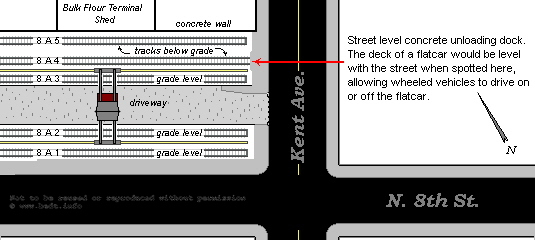
.
.
.
.
The Brooklyn Eastern District Terminal also did
not have any
outsize or height limits on it's freight handling, and one of the
crowning
achievements of Brooklyn Eastern District Terminal freight
handling
(and a record setter) was the transport of a naval rifle weighing
300,175
pounds destined for the Brooklyn Navy Yard! It could handle anything
the
carfloats could carry that the locomotives could pull.
Interestingly enough, the Brooklyn Eastern District Terminal was once considered to have the best crane facilities in the East, with cranes that ranged in capacity from 5 to 40 tons. Below are photos of two of the overhead gantries that operated on BEDT property.
Three of the images are of the gantry located in the North 8th Street yard and this is believed to be the first of several gantries installed by the BEDT sometime after 1924, as it does not appear in Fairchild Aerial photo of that year. The top two images, are from a circa 1930's BEDT advertising brochure. The left middle is from the authors collection. They show the Chesapeake Crane 5/25 ton capacity gantry in use.
Note the solid tire, chain drive trucks waiting to receive the loads. In the top left photo, the small sheave and pulley system (rated for 5 ton and not in use in this photo) is idle, while the larger set up (in use) was rated for 25 ton. In the top right photo, the 25 ton system is idle and an electro-magnet is now attached to the 5 ton hook and sheave, and lifting what appears to be scrap railroad car wheels (they are flanged) and placing them in the wood sided gondola.
|
|
|
|
|
North 8th Street Yard Gantry (looking east) - ca. 1930 |
..... |
North 8th Street Yard Gantry (looking west) - ca. 1930 |
| .
. |
||
|
|
||
| .
. |
||
|
|
||
| .
. |
||
|
Dave Keller had these two images in his archives of the North
8th Street Gantry in use with a drop end gondolas, and are
shown here:
. . . .
|
||
|
|
||
| .
. |
||
| This bottom photos however, are the North 6th Street Yard Gantry (which in fact was closer to North 7th Street). This gantry was a Niles Electric Crane with a 20 ton lifting capacity. | ||
|
|
||
| .
. |
||
|
|
||
.
Several more gantries would be purchased and
constructed for
a total of five gantries as stated in the 1952 June Railroad Magazine
article
by Melvin Krampf. It appears that at least one gantry was
located in
each yard as we have seen gantries in the photos of locomotives working
in
the North 5th, North 7th and North 8th Street yards.
The BEDT also employed the use of both tracked and wheeled self propelled cranes (cranes on truck bodies) which by their nature were more mobile and could be placed anywhere they were needed. These cranes appear in many photos of the locomotives, so if you wish to view them, please reference the locomotive roster pages.
In the later years, heavier loads became increasingly common and a little more mundane, and some of these loads were electrical transformers. According to Joe Roborecky, Consolidated Edison a/k/a ConEd (the utility company in the New York Metro area) would receive very large transformers via the BEDT, for their power plants and electrical switching stations located along the East River shorelines.
When these transformers arrived by rail, they were loaded with the other railcars onto a carfloat in Greenville and floated to Kent Avenue. Once the carfloat arrived at Kent Avenue, the carfloat would be "drilled" (freight cars removed) and the freight cars classified and placed in their respective BEDT yard locations. On the scheduled date, the transformer would be reloaded by itself onto the carfloat and floated directly to the ConEd site. Once at the ConEd location, a large capacity crane (either ConEd owned or outside subcontractor) would lift the transformer directly from the carfloat to the ConEd property.
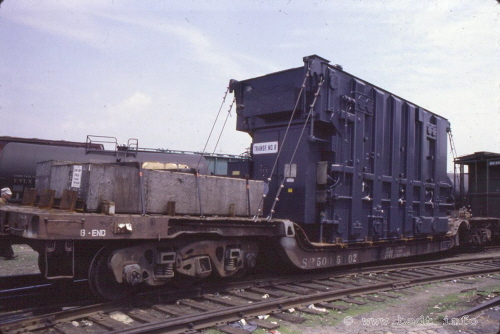
Transformer on six axle depressed center flatcar - July
1981
S. Goldstein photo
authors collection
.
.
.
Inbound Freight Cargo
& Commodities - Arriving in
Brooklyn
| ...........business name | product | location |
|
flour hauling sugar sugar meat packing grocery wholesaler coal supplier coal supplier lumber wood barrels & casks grains & feeds flour lime & cement electric transformers pipe meat packing sugar unknown electrical newsprint rolls sugar rubber works business machines meat packer flour trucking scrap metal sugar meat packing meat packing bed manufacturer meat distributor meat beverage distributor firebrick & cements sugar mustard petroleum products soft drinks copper mixed commodities tallow brewery paper dealer coal supplier steel semolina & flour petroleum products unknown commodity chemicals meat packer flour trucking sulfur plant various coal, shipbuilding meat packing hay lime cement paper |
unknown Kent Ave. & S 3 St. § Kent Ave. & N 3 St. Wythe Ave. & N 5 St. Kent Ave. & N 3 St. Wallabout Canal / Newtown Creek unknown N 5 St. Kent Ave. & N 6 St. & N 4 St. N. 10 St. & Bulkhead Kent Ave. & N 8 St. Kent Ave. various locations Brooklyn Navy Yard Wythe Ave. & N 5 St. Kent Ave. & N 7 St. unknown § unknown Pidgeon St. Kent Ave. & S 3 St. § Kent Ave. & N 8 St. Kent Ave. & N 3 St. N 5 St. unknown Kent Ave. & N 11 / N 4 St. Pidgeon Street N 5 St. N 5 St. Wythe Ave. & N 3 St. unknown (possibly N 5th St.) N 5 St. Pidgeon St. N 5 St. Pidgeon St. Metropolitan Avenue (team trk dlv'y) Newtown Creek (Bridgewater St.)? § Pidgeon St. § Newtown Creek § Kent Ave & N 5 St. Pidgeon St. Kent Ave. & S 9 St. § Wythe Ave. & N 3 St. Berry St. bet N 4 & N 5 Sts Brooklyn Navy Yard N 9th St. Bushwick Inlet (N14 St.)§ Wythe Ave. & N 5 St. Pidgeon St. § Wythe Ave. & N 5 St. Berry St bet Grand & N 1 St N 10 St. & East River bulkhead Brooklyn Navy Yard Brooklyn Navy Yard Wythe Ave. & N 5 St. Kent Ave. & N 10 St. Kent Avenue Pidgeon Street as well as N 9 St Kent Ave. & N 9 St |
.
.
..
.
Outbound Freight Cargo
& Commodities - Departing
from
Brooklyn.
By no means, after receiving these loaded cars;
were they returned
to the mainland empty. While some would be, some cars would be loaded
with
finished products such as refined sugar, wire, tubing, and agricultural
supplies,
some of which were shipped in "less than car load" lots, were sent off
to
various parts of the country. Some of these shippers
were:
.
|
.
Several shipping receipts and arrival notices (NYCS Form AR40-6) dated 1944, that I have accumulated, show:
Perhaps what is most amusing; is that
3 reels of lead pipe, weighing 1776 lbs., were shipped from Charles
Millar
& Son in Brooklyn, NY; to C. B. Hubbard of Davenport Center, NY
and the
freight charges cost "only" $7.64.
Also originating at the Brooklyn Eastern
District Terminal,
are an untold number of shipments of scrap metal received from the
hundreds
of metal and auto scrap yards throughout Brooklyn and Queens. The
Brooklyn
Eastern District Terminal operated a scrap metal handling facility,
with
gantry equipped electro-magnets, and depressed or below grade rail
tracks
for quick bulk loading of gondolas.
These recyclers sent countless thousands of tons
of scrap metal
back to the steel mills in Pennsylvania by rail gondola
to be
recycled, by way of the Brooklyn Eastern District Terminal.
.
Terminals,
Facilities
& Yards - 1870 - 1983
.
|
Terminals & Yards: Location, Dates of Service & Car Capacity List |
|
Terminals, Yards
& Trackage - Overview
The map below
shows BEDT yards and locations
and respective water routes to and from the other terminals in 1952,
that
it exchanged carfloats service from in the New York Metropolitan area.
By
1952, the Warren Street Terminal had already closed, and the Wallabout
Terminal
was incorporated into Navy Yard operations, so they are not listed.
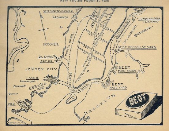 Railroad
Magazine, BEDT Route Map - June 1952
|
.
.
Included in this property, are the piers
of which either
track were laid upon or piersheds and / or buildings were
built for
the storage of freight, hay and such.
.
.
Listed on page 108 in the book: "Ports of the United States" by Grosvenor M. Jones, 1916; are the dimensions of the piers under the ownership of the Brooklyn Eastern District Terminal at their Kent Avenue facilities. I have reproduced them here:
.
| location | dimensions..... | occupant |
| North 3rd Street | 319' x 73' | |
| North 4th Street | 150' x 60' | |
| North 4th Street | 221' x 15' | |
| North 4th Street | 255' x 32' | |
| North 5th / 6th Street | 375' x 39' | West Shore RR |
| North 6th Street | 365' x 60' | West Shore RR |
| North 7th Street | 378' x 70' | |
| North 8th Street | 440' x 30' | |
| North 9th Street | 411' x 35' | |
| North 10th Street | 393' x 20' |
Ports
of the Unites
States, 1916
Department of Commerce - Bureau of Foreign & Domestic Commerce
Miscellaneous Series - No. 33
Report on Terminal Facilities, Commerce, Port Charges,
and Administration as Sixty-Eight Selected Ports
by Grosvenor M. Jones
There were several railyards
under the control of the Brooklyn Eastern District Terminal or that the
Brooklyn
Eastern District Terminal had access to throughout its history.
Some would last the duration from 1870 through 1983, while others may have only lasted a few years. Below is a table containing the dates of service of the Palmer's Dock / East River Terminal / Brooklyn Eastern District Terminal yards, with geographical location and car capacities (where known).
Below, you will find the histories behind each terminal, facility and yard. Some are quite detailed while others are still being researched. If you desire specific information on a particular location, please click on it.
Location, Dates of Service & Car Capacity List
|
yard |
location |
dates of service |
capacity ¥ |
| Kent Avenue North 3 - North 12 St... | Williamsburg, Brooklyn | 1870 - 1983 | 800 cars |
| Kent Avenue South 3 | Williamsburg, Brooklyn | ca. 1952 | 100 cars 1 |
| Wallabout Market Terminal | Williamsburg, Brooklyn | 1937 - 1941 | 90 |
| Brooklyn Navy Yard | Williamsburg, Brooklyn | 1941 - 1983 | unknown but vast |
| Pidgeon Street | Long Island City, Queens | 1906 - 1976 | 100 cars |
| 13th Street (Queensboro Terminal) | Long Island City, Queens | 1914 - 1930? | unknown - probably none |
| Warren Street | Jersey City, NJ | 1910 - 1927 > | 100 cars 2 |
| Greenville Yard | Jersey City, NJ | 1976 - 1983 | 1000 + cars |
¥
= capacity
shown is for
standard 40' boxcars
and peak year of traffic:
1952
1 =
capacity shown is for
direct from carfloat service, approximately 4 to 5
carfloats
2
=
capacity shown is for 35'
cars
Kent Avenue - North
3 through North 12 Streets
| ....Robinson, Bromley & Belcher Hyde Property Maps: | |||||
| Brooklyn North "Red Survey" Maps: | 1898 (rev to 1916) | ||||
| Sanborn Fire Maps: | 1888 | 1905 | |||
| ....................Subway Tunnel Contract Survey Photo: | 1920 | ||||
| City of New York - Bureau of Engineering Aerial Photo: | 1924 | ||||
| .. Fairchild Aerial Survey Photo: | 1929 | 1949 | |||
| .. ....US Army Corp of Engineer Port Series Maps: | 1966 - 1983 | ||||
| .BEDT / City of New York Board of Estimate Map: | 1944 | ||||
| ... . BEDT Office of Terminal Engineer Maps: | 1921 | 1969 (cleaned) | |||
| ............. BEDT Track Blueprint: | |||||
|
. |
|||||
The maps below are a compilation of Sanborn Fire, maps, property / tax maps of E. Robinson, G. W. Bromley and E. Belcher Hyde Atlases, and Corp of Engineer Port Series maps. Also included here are Aerial Photos and Subway Contract Photos.
The Sanborn and Port Series maps are more accurate in terms of track structure, but the old property maps show the customers and property owners.
All are important in showing the history
regarding Brooklyn Eastern District Terminal trackage.
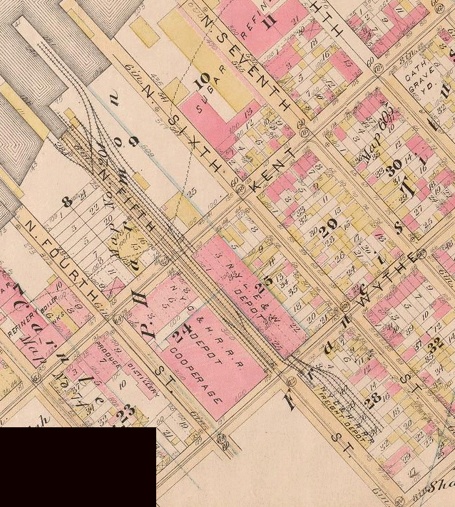
1886 E. Robinson Atlas
North
is
up.
New York Public Library Digital Collections
.
As of February 2008 (I found them in May), the New York Public Library scanned these 1886 and 1898 E. Belcher Hyde maps (which were not available when I added the 1907 and 1929 maps to this chapter). These maps contain a great deal more detail as to the trackwork for those years, than opposed to the simple Geological Survey Maps listed above. Yet another desirable aspect of these E. Belcher Hyde and G. W. Bromley maps, is that they list principle businesses and industries in the area, property and street dimensions.
As can be seen in this map on this very early date, one float bridge at the foot of North 5th Street has been built. This confirms for us that the first float bridge to be located in Brooklyn (much less that of Palmer's Dock / Brooklyn Eastern District Terminal) was at North 5th Street. There is also one set of pier tracks shown (block 9), and the trackage is centered around North 5th Street.
This map also shows what little yard trackage existed this time, but that the majority of this trackage is situated north of the float bridge. Note how two tracks cross Kent Avenue, enter the west face of, and run through the entire length of New York, Lake Erie and Western RR Freight Depot (block 25), and then exit the east face to cross Wythe Avenue to the block east (block 28).
Of those two tracks exiting the New York, Lake Erie & Western RR Depot; note how the northern track splits up to a four track yard, with the southern track of that yard appearing to serve the north wall of the New York Central & Hudson River RR Depot. The southern track that exits the New York Lake Erie & Western Depot appears to enter the west face of New York Central & Hudson River RR Depot as it did for the New York, Lake Erie and Western RR Depot one block west.
This arrangement would give two competing railroads indoor freight handling service in Brooklyn. At least there is a track running around the south face of the New York, Lake Erie & Western Depot along North 5th Street, so car movements for the New York Central & Hudson River would not be hampered by those cars on the southern run through track of the New York Lake Erie & Western Depot.
On the south side of North 5th Street, we see the street trackage for the New York Central & Hudson River Depot and the Cooperage (block 24), which appear to be of loading dock variety along the north wall, as there are no turnouts or stubs.
During a research "get together" on 10 June 2009; between Tom Flagg, Joe Roborecky and myself , Tom "bestowed" upon me high resolution copies (albeit in black & white) of 1888 and 1905 Sanborn Fire Maps showing the Palmer's Dock facilities.
The following image, is a 1888 Sanborn Fire Map. These "Sanborn Maps" are much more accurate in regards to track layout and structure design than the Belcher Hyde and Bromley property maps. Both types of maps however serve their purposes well: Sanborn Fire Maps were used by insurance underwriters in assessing the risks of fire based on the structure construction, fire prevention measures (hoses, water plugs, sprinklers, etc) and the vicinity of the structure to water mains, fire hydrants, etc. Property maps show the dimensions of the properties, structures and lots.
This 1888 Sanborn map is perhaps the most accurate map we will encounter showing the original track work as Lowell Palmer had constructed in 1873 - 1876. Oddly, this map shows the New York, Lake Erie & Western Freight House under construction, while the Robinson map above (dated two years earlier), reflects a finished structure. I believe the Robinson Property Map to have been revised, even though the NYPL description does not reflect this.
Also, for those of you that notice, some of the structure are marked for storage of "hogsheads". A hogshead was a large barrel used for sugar and did not have any connection with the meat industry in the area. As Palmer's Cooperage / Brooklyn Cooperage made the wooden barrels ("hogsheads") for the sugar refiners, one can now understand why the structures are marked for hogshead storage.
Please click on the image below to view a high resolution large scale image of the 1888 Sanborn Fire Map. Use your back arrow to return you here, as there is no return link.
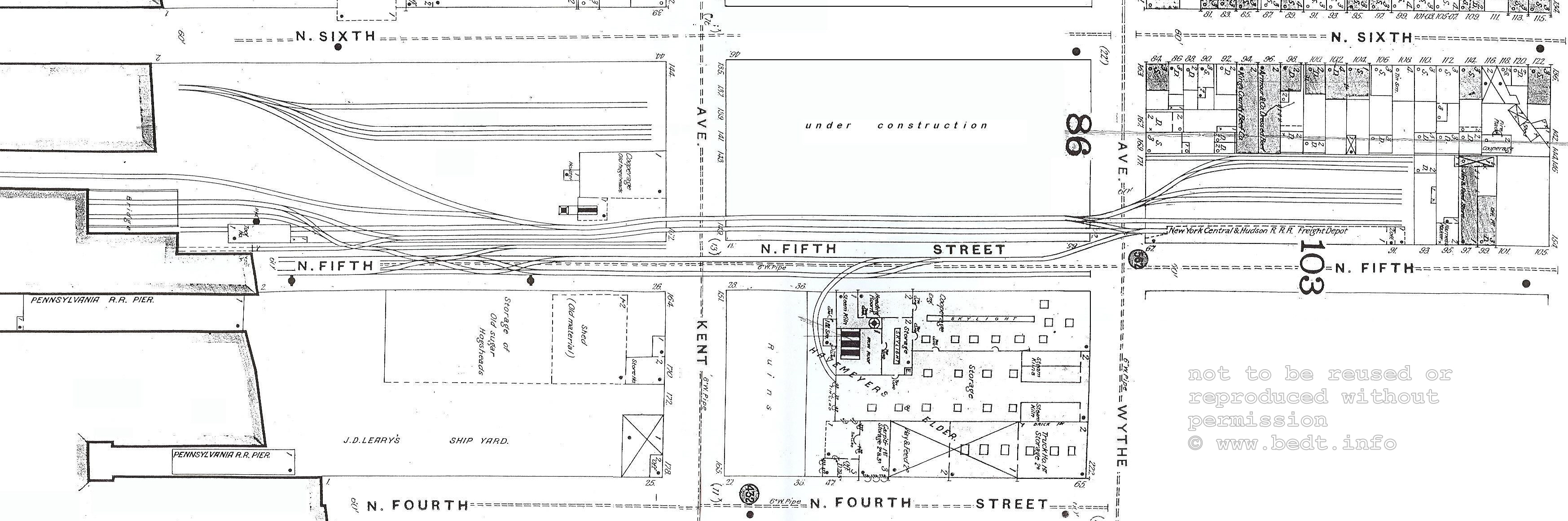
1888 Sanborn Fire Map - Palmer's Docks & Pennsylvania RR
Freight
Station (North 4th through North 10th Streets)
courtesy of T. Flagg
(reoriented for north, and image clean up by author)
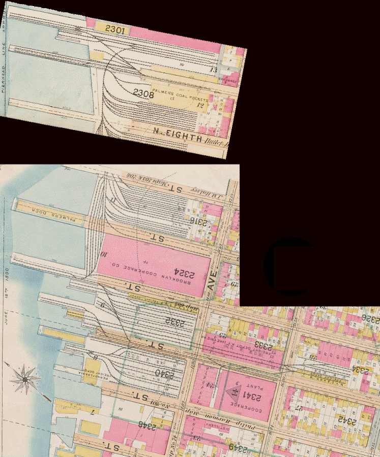
North
is top left.
.
Please
note:
The small disconnected map at top was formerly in-setted on another
plate
in this E. Belcher Hyde atlas and I added to this map for continuity.
Unfortunately, the larger map ( on another page) was oriented facing
right
(west equaling up), and upon rotating it to reflect north equaling up,
the
lettering is now upside down.
A growing expansion of Palmer's Docks has taken place in the ten year span between this map and the one from above. We can now see a turnout had been installed and a spur track extended into the north / south alley of the Brooklyn Cooperage Plant (block #2341) bounded by Kent and Wythe Avenues and North 4 and 5th Streets and a fifth track added in the yard by the New York Central & Hudson River Depot (block #2334). This northernmost track now serves the meat packers located there.
The Pennsylvania RR has constructed their North 4th Street Terminal with a float bridge, south of the Palmer's Docks operations, and no physical connection between the Pennsylvania RR and Palmer's operation shows at this time. (To the best of my research, there never would be a physical track interchange between these two operations.)
It appears from the map, the North 5th Street float bridge has been moved north a few yards (the 1886 map above show it located directly at the foot of North 5th Street), and the North 5th Street yard expanded (block #2332). The map reflects another float bridge has been built just south of North 6th Street as well as a narrow freighthouse and that is occupied by the New York Central & Hudson River RR.
However, the greatest trackage / property expansions took place north of North 6th Street. From the map, we can see Brooklyn Cooperage has constructed a large building occupying almost the entire block (block #2324) located between North 6 & North 7th Streets. While most of the yard tracks constructed by Palmer would be oriented east / west, there had been constructed six or so tracks along the bulkhead oriented north / south at this location. This yard was in essence two blocks long (North 6th to North 8th Streets) and appear to have served the west face of new Cooperage structure. There was also service along the south face (North 6th Street) as well as north face of (North 8th Street) of this new Cooperage structure.
Also seen, several railyards have been constructed west of Kent Avenue in the blocks of North 7th to North 8th (block #2316) and North 8th to North 9th Streets (block #2308) and North 9th to North 10th Street (block #2301). The disconnected map section at top shows "Palmer's Coal Pockets" (block #2308) located by North 9th Street and Kent Avenue. This is the "famous" coal depot as built by Lowell Palmer, that can be read about in the Brooklyn Eagle article of October 12, 1892. See Palmer's Dock Coal Depot for that article.
We also see, the North 9th Street float bridge is in service at this time, as well as a nice sized yard to service both Brooklyn Elevator & Milling (grain mill) and North 9th Street Hay Storage building, both of which has also been constructed as of this year.
Located in the New York Municipal Archives Digital Collection in July 2026; we are fortunate to have reference to these two "Brooklyn Red Survey" Maps, initially drawn in 1898.
The maps were created for the purposes of waterfront surveys. In most cases, any and all improvements made to the pier line, bulkhead line and waterfront property were to be noted on these maps; however, I have encountered missing landmarks on other maps (chiefly the Jay Street Terminal series).
Subsequent revisions were made in varying colors, predominately red (but also in other colors), hence the the "Red Survey Map". There are three maps pertaining to the Brooklyn Eastern District Terminal: Brooklyn North 14 (Kent Avenue, Grand Street to North 6th Street) and Brooklyn North 15 (Kent Avenue, North 6th to North 12 Streets) and Queens 21 (Pidgeon Street Terminal).
I have stitched maps 14 and 15 together and cropped it to North 3rd Street, as BEDT operated no property south of that street. Please click on the "thumbnail" below for a high resolution version.

1898 - Brooklyn North "Red Survey" Map - North 12th Street through North 3rd Street
North is right.
New York Municipal Archives - Image ID: REC 0133 1 0938 and REC 013 31 0937
Department of Records and Information Services (DORIS)
stitched plates:© 2026 - Philip M. Goldstein / freightrrofnyc.info
added 23 July 2026
During a research "get together" on 10 June 2009; between Tom Flagg, Joe Roborecky and myself , Tom "bestowed" upon me high resolution copies (albeit in black & white) of 1888 and 1905 Sanborn Fire Maps showing the Palmer's Dock facilities.
The following image, is a 1905 Sanborn Fire Map. These "Sanborn Maps" are much more accurate in regards to track layout and structure design than the Belcher Hyde and Bromley property maps. Both types of maps however serve their purposes well: Sanborn Fire Maps were used by insurance underwriters in assessing the risks of fire based on the structure construction, fire prevention measures (hoses, water plugs, sprinklers, etc) and the vicinity of the structure to water mains, fire hydrants, etc. Property maps show the dimensions of the properties, structures and lots.
This Sanborn Fire Map, like its 1888 version
above; is very informative to the use of many of the Palmer's Docks
structures
located on the property. Of special importance was the fact:
There are TWO engine houses located on the property in 1905: one located by the North 5th Street float bridge, and the second was constructed by the North 9th Street float bridge. It is logical to conclude that the North 5th Street engine house was constructed first, as this was the location of Palmers initial operation and location of the first float bridge.
It appears the the Brooklyn Fire Department's "David A. Boody" fire boat was stationed at the North 8th Street Pier.
The Baltimore & Ohio Railroad (along with Central Railroad of New Jersey and the Philadelphia & Reading Railroad) is shown to be occupying the North 7th Street Freight Shed. This is significant because the Baltimore & Ohio RR had opened their own offline terminal located at North 1st Street around 1890. This location was subsequently occupied by the New York ,New Haven & Hartford Railroad around the time of this Sanborn issue.
Finally,
we obtain the name of the rubber works, Eugene Dougherty.
Please click on the image below to view a high
resolution large scale image of the 1905 Sanborn Fire Map. Use your
back arrow to return you here, as there is no return link.
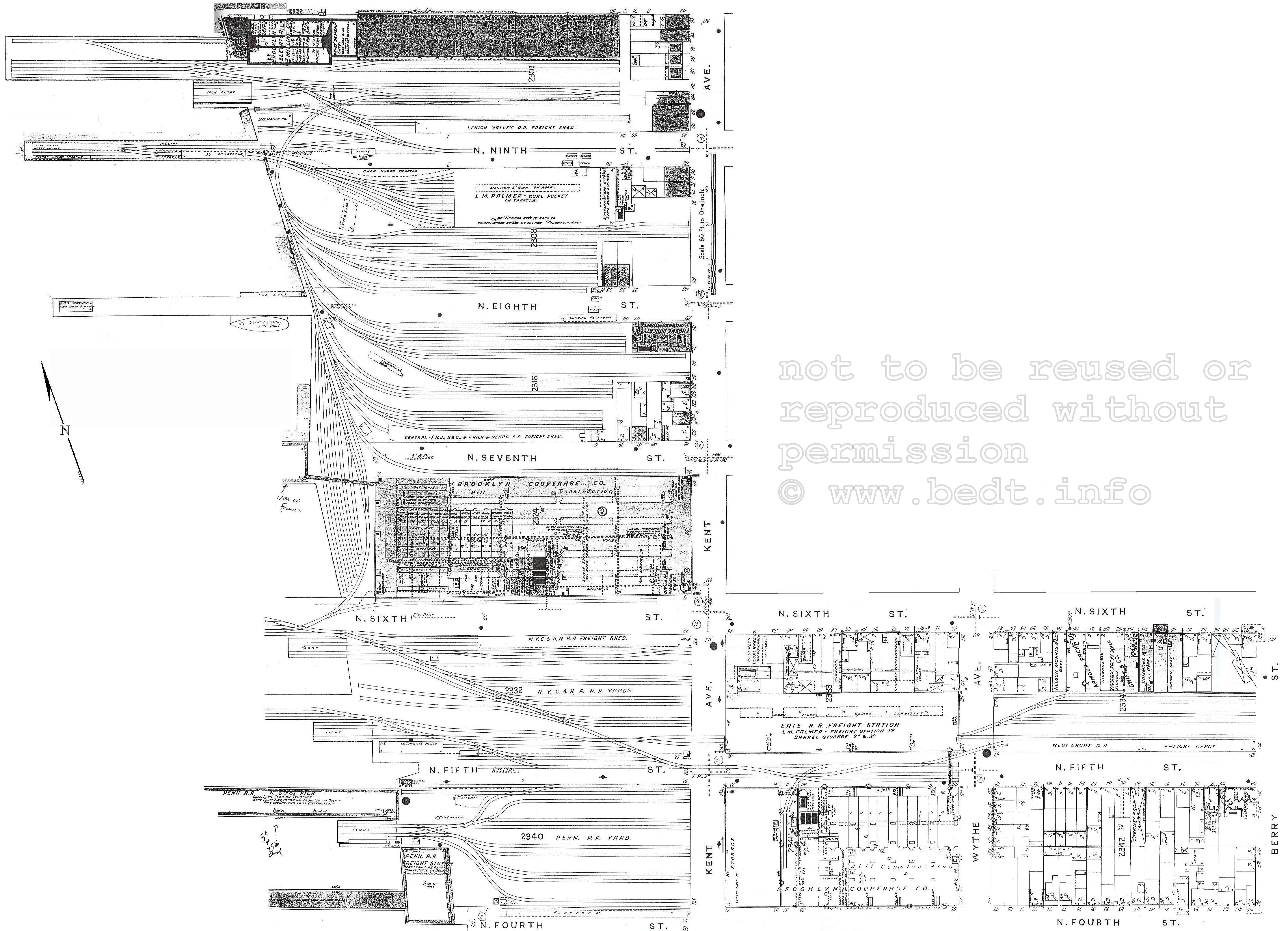
1905 Sanborn Fire Map - Palmer's Docks & Pennsylvania RR
Freight
Station (North 4th through North 10th Streets)
Reoriented for north, and image cleaned up by author.
courtesy of T. Flagg
1907 /
1908 - G. W.
Bromley & Co.
Atlas

North is top left corner.
.
In August 2007, Jay Wanczyk emailed me a map from the 1907-1908 G. W. Bromley & Co Atlas. The Brooklyn Eastern District Terminal is not mentioned, which is odd in itself as the Brooklyn Eastern District Terminal was organized in 1906. I can only hazard a guess the maps were drawn and compiled prior to the Brooklyn Eastern District Terminal being organized in 1906, but the actual atlas that the maps were contained in was released in 1907-1908.
Oddly, this map shows a connection between the Pennsylvania RR yard between North 4th and North 5th Streets, and the track lead running on the south side of North 5th Street and running one block east to Wythe Avenue, to service the Brooklyn Cooperage (block #2341) which was located on the south side of North 5th Street. As far as we know, the Pennsylvania and Palmer never had a physical track interchange. Also, as far as history dictates; it was Palmer's operation that serviced the Cooperage, but this map shows Pennsylvania RR trackage at the north wall of the Brooklyn Cooperage.
There are a few discrepancies worth mentioning in this map: There is no apparent connection to the tracks on the west end of the Erie Freight Depot, but we can conclude from referencing either the 1898 or the 1929 E. Belcher Hyde maps, that this trackage did indeed connect to the West Shore yard on North 5th Street and "ran through" the Erie Freight Depot from Kent Avenue just north of North 5th Street. This apparently is an error.
What has not been determined to be an error, is that we can see the trackage in the "West Shore Freight Yard" is not connected to the remainder of the trackage of "Palmer's Dock Yards" along the bulkhead north of North 6th Street. Did this break truly exist?
Another most interesting discovery, shows the Central Rail Road of New Jersey (yup, they were there too apparently!) had a freight depot on the north side of North 7th Street, between the bulkhead and Kent Avenue.
On the southwest corner of Kent Avenue & North 8th Street was a Rubber Factory that apparently had rail service from Palmer's Dock. It appears this structure is built upon the former location of the coal pockets.
As for float bridges, the Pennsylvania had theirs, in it's expected location between North 4th and North 5th Streets. the West Shore used the North 5th Street and North 6th Street float bridges (that would become Brooklyn Eastern District Terminal), and Palmer's Dock had another float bridge now located at North 9th Street, which would also become the Brooklyn Eastern District Terminal.
Thanks to Jay and this map, we learn that not only the Pennsylvania and Erie railroads, but now the West Shore and Central Railroad of New Jersey had a presence in Williamsburg prior to the Brooklyn Eastern District Terminal organization.
1920 - Subway Tunnel
Contract Survey Photo
.
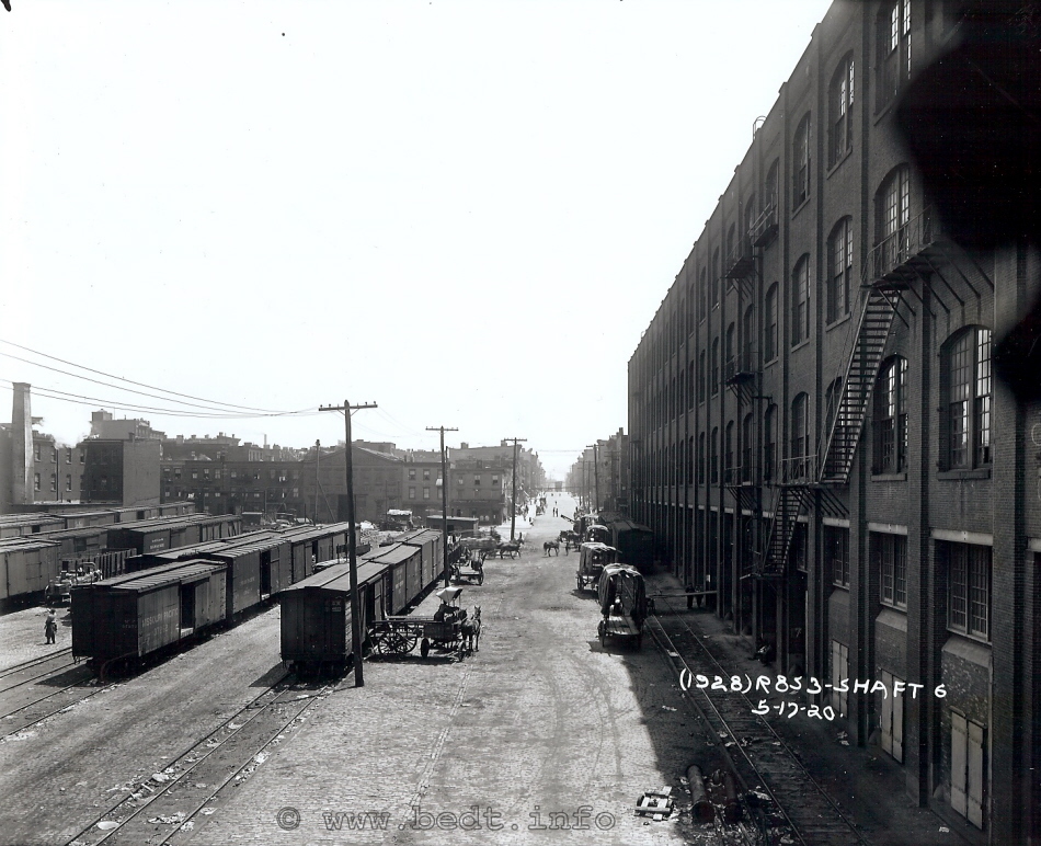
This photo was taken in May 17, 1920 as part of the surveying for the tunneling contract for the BMT 14th Street - Canarsie Line (currently the "L" line) and for the apparent location of the ventilation shaft so commonly seen in later photos of the Brooklyn Eastern District Terminal. While this photo is also included in the Property Page, it is also included in this chapter because of its historical significance.
This photo which was taken looking east and I believe was taken from roof or at least a second story window of the front of Palmer's Dock Pier Shed at the foot of North 7th Street.
The structure along the right (southern) edge of the image is the north wall of the Brooklyn Cooperage. Note how a single track runs along the inside of the south curb line of North 7 Street. This track was in fact connected (below the photographer and out of view) to the North 7th Street "A" Yard seen to the left (north) of North 7th Street.
Along the north curbline of North 7th Street from the bottom left corner of the photo and to the end of the freight cars along that track, was the site of the Central RR of New Jersey freighthouse that was leased to them by Palmer / Havemeyer. This freight depot is also shown to be inhabited by Baltimore & Ohio & Philadelphia & Reading Railroads. This freight depot is not shown on the 1898 E. Belcher Hyde Property Map, but is shown in the 1905 Sanborn Fire and 1907 / 1908 G. W. Bromley Property Maps, and apparently gone by 1920. This freight shed only held that single track running through its center, from east to west.
Behind the rows of freight cars in this yard and along Kent Avenue, construction debris can be seen along with a ramshackle construction shed visible as well. There were several structures here as shown on the 1905 Sanborn Fire Map, and they appear to have been demolished about the time of this photo. The smokestack and three story brick structure seen on the left edge of the photo is the Eugene Doherty Rubber Works.
While the following is not related to Palmer's Dock / BEDT, it is interesting enough to mention. Across Kent Avenue on the northeast corner is what appears to be a bar / tavern. Joe Roborecky has identified a set of swinging doors like those typically seen in saloons in the old west. The sign over this store front / tavern appears to read: Obermeyer & Liebmanns.
The third lot north from the corner (the building with the peaked roof and dark windows: 111-113 Kent Avenue) is the establishment of Henry Lonse, who was the proprietor of a wagon shop. Apparently, (by reading the signage on the front of the building), he has now expanded to the repair of auto bodies & trucks as well as wagons.
City of New York,
Bureau of Engineering - 1924 Aerial Photo
Here comes Tom
Hendrickson again, this
time with a doozey! He located in the New York Public Library Digital
Archives, an aerial photo
of Brooklyn and Manhattan, which including the Williamsburg
neighborhood.
Fortunately, this map was "zoomable", albeit in quadrants. I enlarged
the
North 3rd through North 12th areas and stitched the quadrants together
in
MS Paint.
This map is rather large but quite detailed, so I didn't want to compress it and lose the detail and place here. So, I gave it it's own page. Click on the small map below, if you wish to view the large version. By the way, this is one of the first aerial photos of New York City, and is part of the Fairchild Aerial Survey series.
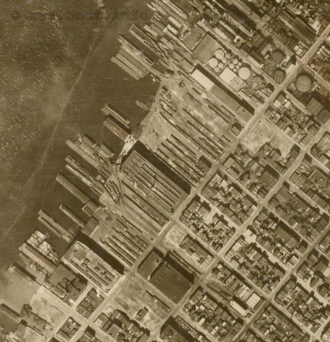
Fairchild Aerial
Survey Photo - 1929 Aerial Photo
Joe Roborecky
located the
following image, which is a Fairchild Aerial Survey photo from 1929.
This
photo is an oblique view, compared to the direct overhead 1924 Aerial
Photo
in above chapter. He located this image in the
New York Public Library Digital Collections
and I enlarged the appropriate area and stitched the sections together
in
MS Paint.
In this 1929 photo, we can see a steam locomotive peaking out of the Austin Nichols building, and blocking the sidewalk up by North 4th Street. There is another steam locomotive in the PRR North 4th Street Yard (but this is in all likelihood, not a BEDT loco.)
We see that the Brooklyn Cooperage building has been razed (which was still standing five years earlier) and the railyard that took its place is already in service. The NYC Subway airshaft for the BMT 14th Street - Canarsie Line has been built at the foot of North 7th Street, but the bulkhead trackage that we have come to know in later years is not yet built. It appears one of the original Palmers Dock piersheds is still in the process of being razed to the right of this airshaft.
Oddly, I would have expected to see more locomotives in this photo, but there are not. Also, the engine house has not yet been built at the foot of North 8th Street, but we can see a locomotive stored at this part of the property. I believe this to be #8, as it appears the saddletank is off (saddletank locomotives have tall domes on top of their boilers to accommodate the height of the saddletank). These domes are visible on top of this object, and as we have seen in a photo, this locomotive was out of service around this time and not scrapped until ca. 1933.
Also, on North 9th Street at Kent Avenue, a wood fence (left of the boxcars) is erected around a building foundation under construction. I believe this to be the "new" BEDT office building under construction.
There is a significant amount of flat cars with some sort of commodity both at the North 7th Street gantry, as well as at the North 9th Street Pier Yard and on a carfloat at the North 9th Street float bridge.
This photo is rather large and quite detailed, so I did not want to compress it and lose the detail and place here. So, I gave it its own page. I highly suggest you compare both the 1924 and 1929 images to see the progress. Take note, they are both large files and take a few moments to load.
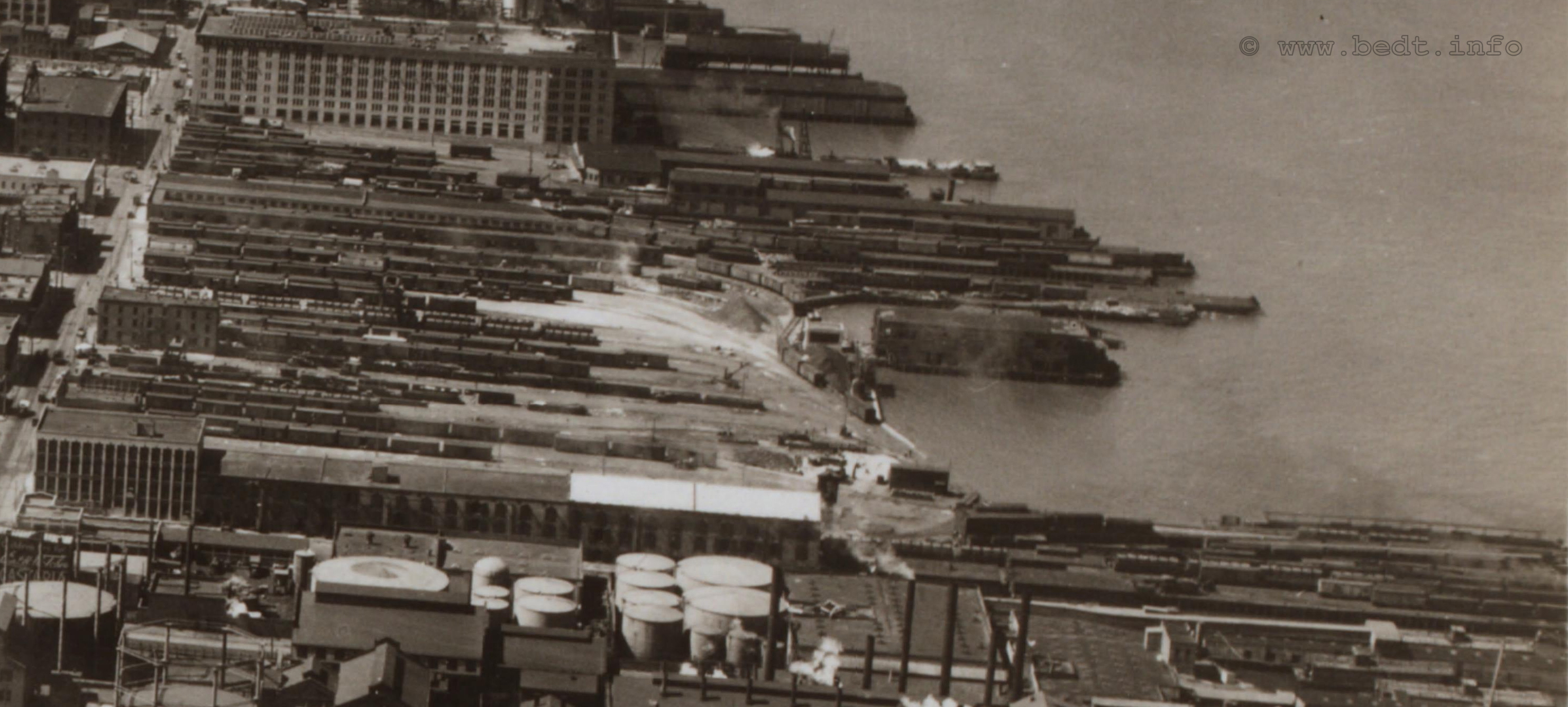
1929
- E. Belcher Hyde Maps
|
|
..........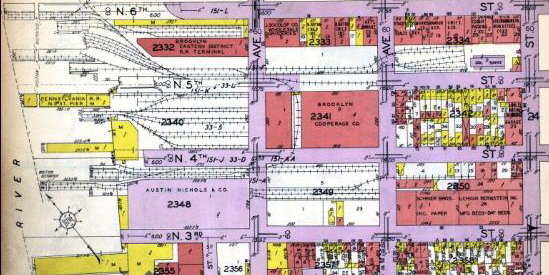 |
North is top left.
Please
note:
While the lower map accurately denotes the locations and track leads to
the
float bridges, the upper map does not. Both are from the same volume
and
date.
.
From
these maps we can now compare
the expansion of trackage that took place under the Brooklyn Eastern
District
Terminal. The Austin Nichols building is now shown between North 3rd
and
North 4th Streets (having been completed in 1915). This "new" trackage
is
now in place south of North 4th Street as well as a float bridge just
south
of the foot of North 4th Street. As it was just south of the end of the
street,
it was referred to as the North 3rd Street float bridge and so as not
to
be confused with Pennsylvania RR's North 4th Street facility.
The Austin Nichols construction appears to have dramatically increased trackage between North 3rd and North 4th Streets as far east as Berry Street. To gain access to the North 3rd Street / Austin Nichols trackage from the original yards and without "touching" Pennsylvania trackage, we can now see the North 3rd Street trackage and yards is accessed through the mid-block transverse alley between North 4th and North 5th Streets and between Kent and Wythe Avenues (tax block #2341). This alley was called "the tunnel" by locomotive engineers.
The Austin Nichols building has both an outside three track yard (3A Yard) on the north face of the building, and indoor "run through tracks" that enter on the west end of the building on the bulkhead and off the pier tracks built for Austin Nichols (3P yard). Two of the three outside tracks cross Kent Avenue, with a spur splitting off of the north track and turning north to go through the transverse alley mentioned above, for access to North 5th Street trackage and the northern Brooklyn Eastern District Terminal yards. The two outside tracks continue east on the north edge of tax block #2349 for car storage (north part of 3B Yard), but do not cross Wythe Avenue.
The indoor tracks had an elaborate system of trackside conveyors to move freight throughout the building. Upon exiting the east end of the Austin Nichols building, the tracks cross Kent Avenue and proceed east through the center of tax block #2349 (south part of 3B Yard) as well and do not cross Wythe Avenue either. However, a spur off that northern track splits off and proceeds to cross Wythe Avenue at which this spur gives service to Schrier Brothers Paper and Lehigh Bernstein bed manufacturing, located between North 3rd and North 4th Streets, and Wythe Avenue and Berry Street (tax block 2350). This is now the eastern most end of North 3rd Street trackage.
Pennsylvania RR trackage along the south side of North 5th Street no longer appears and the Erie Freighthouse on North 5th Street between Kent and Wythe Avenues appears to have been demolished. Some trackage from the central north portion of the former West Shore yards between North 5 and North 6th Street (6A Yard), between the bulkhead and Kent Avenue, (tax block #2332) has been removed for the construction of the North 5th Street Freighthouse.
Proceeding east along North 5th Street, three tracks cross Kent Avenue, with the southern most track turning south to meet the track at the transverse alley. The two remaining tracks would continue to run east along the south side of tax block 2333 and along North 5th Street to cross Wythe Avenue. The northern track would serve the meat packers and the southern most track would go on to split in a four track stub yard with service to a new coal dock, perhaps to replace one the one that stood at North 9th and Kent Avenue.
The Brooklyn Cooperage building between North 6th and North 7th Streets and the bulkhead and Kent Avenue has been demolished, and the land used for an extensive railyard (6A Yard), and it appears a couple of tracks in the North 7th Street yard (7A yard) between the rubber factory and the bulkhead were removed as well. There are also changes in track configuration in the North 8th and North 9th Street (8A and 9A) yards.
Port Series Track Maps
More accurate
track layout diagrams can
be seen below, which are from the Port Facilities at Port
of New York - Office of the District Engineer New York District, Corp
of Engineers "Port
Series" maps.
The
first one, directly below; is the 1934 edition, with other subsequent
editions
following in chronological order. These are the 1934, 1942, 1953, 1965
editions,
and the J. Roborecky revision to the 1965 edition (bringing it to
reflect
trackage changes from 1968 to 1983). The only Port Series map I lack at
this
time, is the 1924 edition.
We must thank Tom Flagg for making the 1942 and 1953 editions available from his archives. Float bridge locations are denoted as solid black triangles above the numbers on the maps.
1934 edition
- Port Series Map
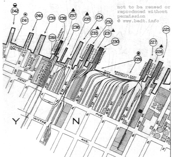
1934 - Port
Facilities at Port of New York - Office of
the District Engineer
New York District, Corp of Engineers
North is right.
authors collection
.
In
the 1934 edition map immediately
above; the enginehouse was located at the end of the four tracks under
the
word TERM under key #228 in the top map. Key #235 is the PRR float
bridge
and yard, and note there is no physical trackage connection between the
BEDT
and PRR trackage in the North 4th Street Yard.
There are five active float bridges on this map: BEDT North 3rd Street (#237); PRR North 4th Street (#235); BEDT North 5th Street (#233); BEDT North 6th Street (#231) and BEDT North 9th Street (#226). Furthermore, there is no trackage north of North 10th Street. Take exceptional note of the extensive yard trackage within the North 6th through North 9th Street area west of Kent Avenue (6A, 7A and 8A yards), and this map reflects the largest amount of yard trackage that would exist on the BEDT.
There are three tracks that run down the center of the North 9 and North 10th Street block (long axis) from the bulkhead (between the North 9th Street floatbridge and the North 9th Pier Yard), to Kent Avenue. The middle track (the lead track) now crosses Kent Avenue toward Wythe Avenue. The northern track were used to service the North 10th Street freighthouse respectively and ended before crossing Kent Avenue (and splitting into two tracks again) The southern track was for yard service and did not cross Kent Avenue either.
Notice there are no tracks that extend north of the North 10th Street freighthouse, and the basin at the foot of North 10th Street (northeast of #225).
1942 edition
- Port Series
Map
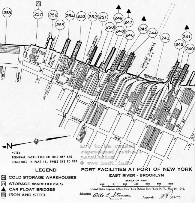
1942 - Port Facilities at Port of New York - Office of the District Engineer
New York District, Corp of Engineers
North
is right.
authors collection
In the 1942 edition of the Port Series maps seen above, you can begin to see the gradual decline of yard trackage taking effect.
In this map, take notice that the North 3rd Street float bridge is not listed. This will become an unusual occurrence, as it is listed in the 1929 Bromley map and the 1934 Port Series Map, disappears from this map and is shown again in the 1953 edition Port Map. Was the North 3rd Street float bridge out of service for a period of time, or did an Corp of Engineer forget to list it?
The subway airshaft for the BMT 14th Street - Canarsie subway line is shown in this map (which opened for service in 1924), but oddly this airshaft is not shown in the future editions of the Port Series maps. On the North 7th / North 8th Street block bounded by the bulkhead and Kent Avenue, much of the yard trackage has been removed and several new structures and in place, with trackage abutting the west faces of those structures, while two tracks run down in between those structures, which were part of the original yard trackage. There are new structures as well on the north edge of North 9th Street with trackage abutting the west face of the building.
Notice the reduction of trackage in the North 7th "A" yard (west of Kent Avenue). Several structures now exist at this location with a two track siding running down an open air "alley" with structures on either side.
There are also some changes to track layout in the North 9th "A" yard (west of Kent Avenue); as the several block long sidings were removed, and buildings erected in their place, and there is now a short two track siding butting up to the west face of the building.
There were some trackage additions. You can also note that trackage now crosses and extends north of North 10th Street, but ends at North 11 before actually crossing that street. Also, the basin at the foot of North 10th Street is now filled in, and North 10th Street is now a little longer. There is a discrepancy in this map as that northernmost track (running east-west) on the North 10th Street Pier (#240) does not connect to the tracks south of it, and as it comes off the pier, it turn north to head towards North 11th Street and between the two buildings.
1944 - BEDT /
City of New York Bureau of Franchise / Board of Estimate
Map
.
This map is attached to the rear inner cover of a 31 page document from the City of New York Bureau of Franchise to the Board of Estimate in reference to a petition filed by the Brooklyn Eastern District Terminal in 1944 regarding the right and lease of trackage that ran in, or across city thoroughfares in the Boroughs of Brooklyn and Queens (Pidgeon Street Yard). If my research is correct, this had to have been done on numerous occasions at ten year intervals to allow the BEDT to enter upon City property, namely the streets. Had the BEDT not crossed any streets and remained solely on their property, this lease would not be necessary.
While much of the document is legal folderol, the gem is the map. Adopted from a BEDT Terminal Engineers map, it shows the layout of the trackage current to the time of filing: 1944. Those segments of track which fall upon city property and required a city lease are marked in red.
Clicking on the image below will take you an enlarged image of the map for better legibility. To read the .pdf document, please click the following link (as this is a .pdf file, there is no return link back to this site. Use the back arrow on your browser to return you here): Bureau of Franchise to Board of Estimate - 1944
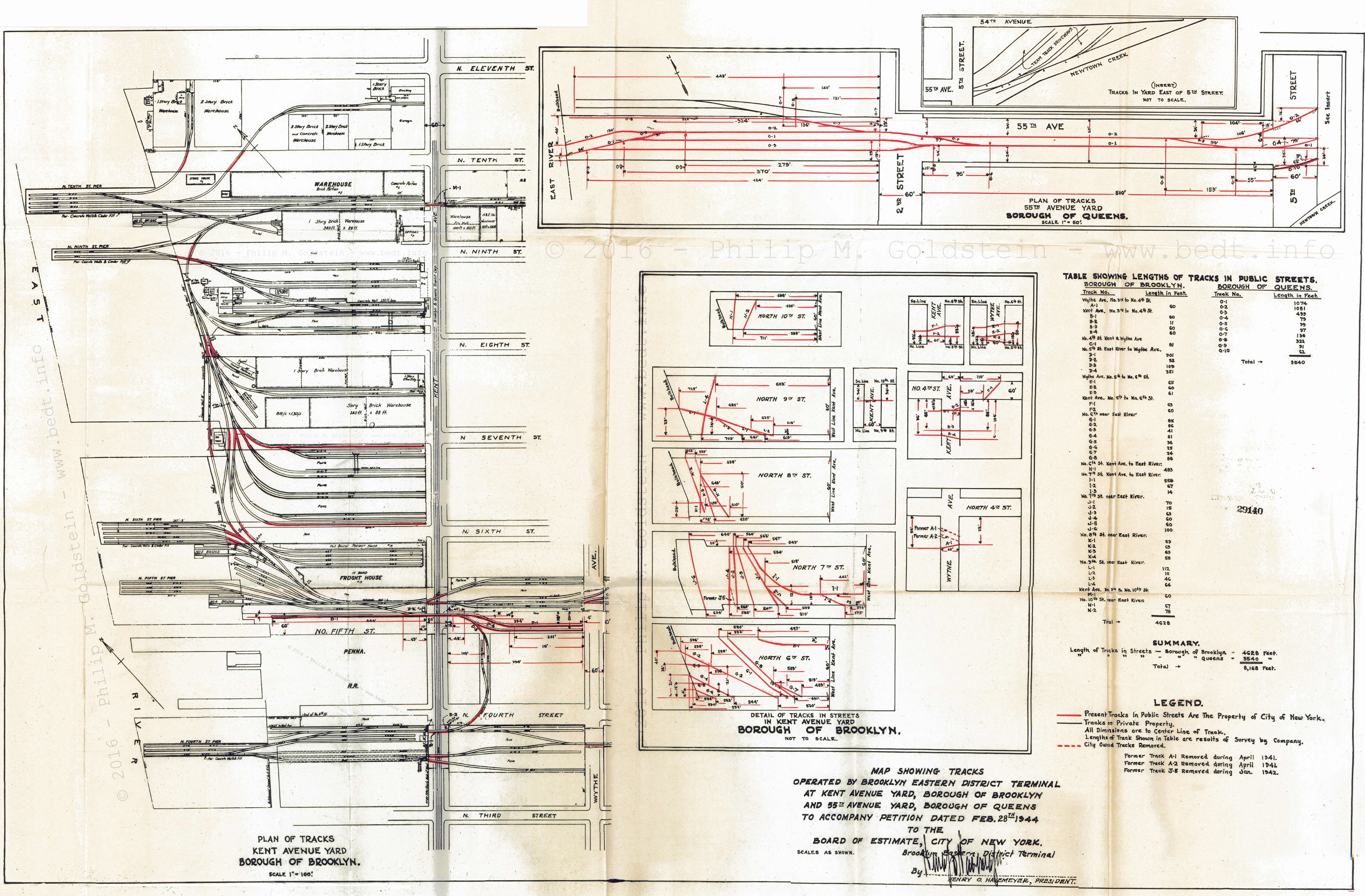
1944 - City of New York, Bureau of
Franchise
to the Board of Estimate
North
is right.
authors collection
added 27 January 2016
Fairchild Aerial
Survey Photo - 1949 Aerial Photo
.
This image is located in the Digital Collections of the New York State Archives, Museum & Library.
Even though Paul, Joe Roborecky and myself have visited this website many times in the past, we failed to come across this image, which is a Fairchild Aerial Survey Photo from 1949. This photo is an oblique view, similar to the 1929 issue above but looking north instead of south. The resolution is remarkable and I enlarged the appropriate areas and stitched the sections together in MS Paint.
In this 1949 photo, we can see (from
foreground to background):
.
This photo, like the other aerial photos, is rather large but quite detailed, and I didn't want to resize and compress it and lose the detail and place on this page. So, I gave it its own page where it can be viewed in great detail. I highly suggest you compare this 1949 images with both the 1924 and 1929 images to see the progress. Take note, they are all large files and take a few moments to load.
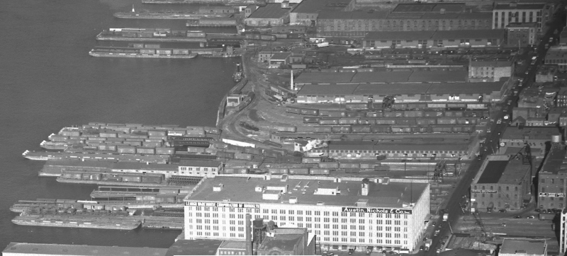
1953 edition -
Port Series Map
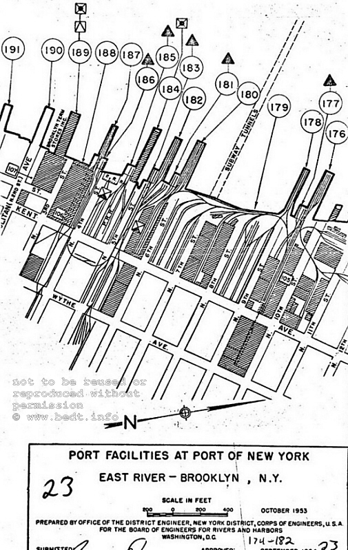
1953 - Port Facilities at Port of New York - Office of the District Engineer
New York District, Corp of Engineers
North
is right.
authors collection
.
.
In
this 1953 edition of the Port
Series Maps, we see that all four BEDT float bridges: North 3rd Street
(#186),
North 5th Street (#183), North 6th Street (#181) and North
9th Street
(#177), and the PRR float bridge at North 4th Street (#185) as
well, are
still in service.
It appears that some of the PRR yard trackage is beginning to thin out, as well the removal of the thin "finger" pier jutting out west from the actual terminal building (#250 in the 1942 map).
Track additions consist of a two track siding almost directly below the North 7th Street subway airshaft and a stub track with one car capacity leading to the back of the building on the south side of North 8th Street.
Extensive trackage is now in place north of North 10th Streets with many spurs and small yard between North 10th and North 11th Street almost by the bulkhead, while another track transverses midblock and splits to into two tracks, one of which turns east to continue to Kent Avenue (after splitting again into parallel tracks) and the other track remaining north to cross North 11th Street and continue to North 12th Street, with that track splitting in three spurs.
1965 edition -
Port
Series Map
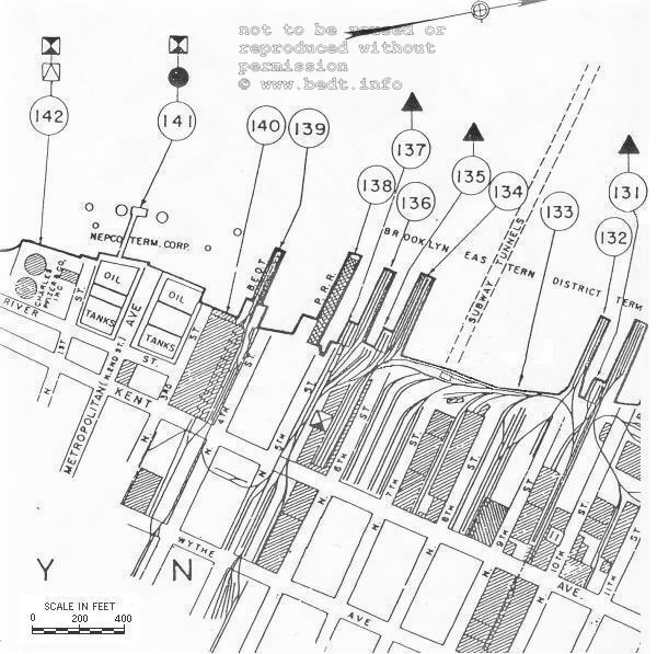
1965 - Port Facilities at Port of New York - Office of the District Engineer
New York District, Corp of Engineers
North
is right.
authors collection
On the left side of this 1965 edition of the Port Map as seen above, you can see Nepco Oil (key #141) has replaced American Sugar Refining between North 2nd and 3rd Streets.
The North 3rd Street float bridge next to the former Austin Nichols building (key #140), which now houses Federal Business Machine (not reflected in map); has been removed from service (no black triangle), but the pier trackage remains.
The Pennsylvania RR float bridge at the North 4th Street Terminal has also been removed from service, as well as the trackage having been removed from the yard, yet the pier shed remains and is marked for PRR. However, according to a New York Times articles submitted by Tom Hendrickson, states that the Pennsylvania Railroad sold the North 4th Street Terminal property to the Brooklyn Eastern District Terminal on May 7, 1954.
The Bulk Flour Terminal has been constructed (in 1964) on the southwest corner of North 9th Street and Kent Avenue and some of the tracks in the North 8th Street Yard west of Kent Avenues have been lengthened to accommodate it.
The North 10th Street freighthouse appears
to have shortened in length to half a block (southside of North 10th
Street,
west of Kent Avenue.)
1966
- 1983 - revised from
Port Series Map
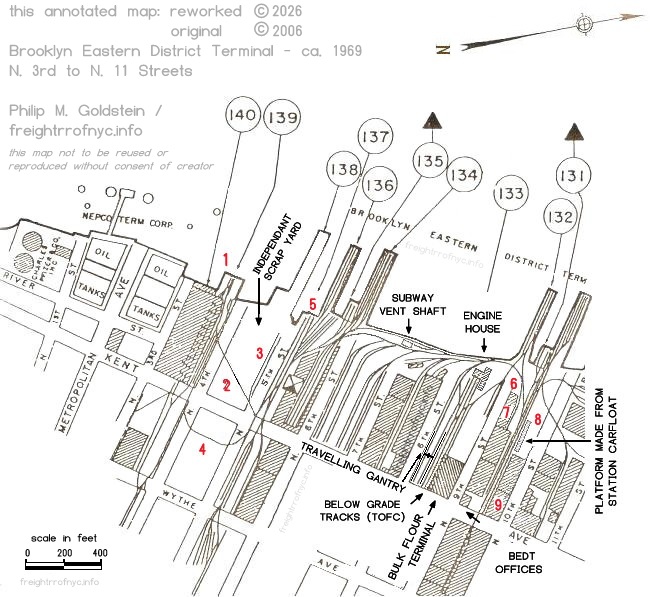
1966 - 1983 - Port Facilities at Port of New York - Office of the District Engineer
New York District, Corp of Engineers -
(modified from 1965 edition)
Modified by author, not to be reused or reproduced without consent.
authors collection
In this map as seen above, the 1965 edition of the Port Series Map has been revised by the author as directed by J. Roborecky, to reflect changes in the trackage after the last edition of Port Series Maps were released. The map above reflects most changes over the period from 1966 through 1983. The revisions are numbered in red on the map and noted below. Important structures and landmarks have also been noted and / or drawn in on this map, even though most of those structures predate this revision.
(1) The pier with trackage and the float bridge "3 Bridge" behind the Austin Nichols building now occupied Federal Business Machine has been removed.
Track additions: Independent Scrap has relocated from North 11 Street to the property of the former PRR North 4th Street Terminal yard, ca. 1966. A diagonal track (2) "4A7" and siding "4A8" (3) being installed so BEDT could bring in gondolas for loading. Independent Scrap by the way, would receive several contracts to scrap New York City Transit Authority subway cars.
Also evident is the elimination of trackage on North 5th Street between Kent & Wythe Avenues, and the "zig zag" (4) siding running through the middle of the block ("the tunnel") bounded by Kent & Wythe Avenues and North 4th and 5th Streets. (former site of Brooklyn Cooperage).
On an unknown date, the North 5th Street float bridge was removed from active service, yet remains abandoned in place (5). This leaves only two float bridges in active service at the BEDT Kent Avenue facility: North 6th Street (key #135) and North 9th Street (key #131).
The "below grade tracks" (for Trailer On Flat Car "TOFC" unloading / loading?) in the North 8th Street Yard are noted. These sub-grade tracks existed prior to this date and are not a change. Also noted is the travelling gantry. This gantry has been in place for many decades as well and survived to this date, and therefore its location is noted in this map.
There were also several changes in the North 9th Street Yard by this date. 9A1 track, was reconfigured to tie in to the lead track with the turnout being located between the crossing diamond and the 8P tracks (6). This reconfiguration however is believed to have existed well before this revision date; when a new structure (7) adjoining the North 9th Street freight house, was built for the purpose of storing rolls of paper for newsprint.
Joe Roborecky maintains the turnout location on the Port maps are erroneous (until this revision), and this turnout location is actually accurate back to at least 1954 and possibly prior to this date; as this turnout location is reflected in the1954 historicaerials.com aerial photo. (If you wish to view this aerial photo, you must type in zip code 11211 to access the Kent Avenue area, then pan left (west) towards the East River, and then set your date accordingly.)
At the western end of the North 10th Street freight house, a covered steel platform (8) from a station carfloat was placed here and parallel to 9A5 track. This platform was used by Semolina Haulage Co. to transfer 80 to 100 pound bags of semolina directly from boxcars into truck trailers. This station carfloat platform was salvaged from the conversion of Carfloat 26, when that carfloat was converted to the centerpipe arrangement for use at the Schaefer Brewery.
It should be noted that this carfloat platform now occupies the location where a "six pack" of cement silos stood. It is believed these concrete silos did not exist long, as no aerial photos in historicaerials.com (1954, 1966 or 1980 versions) show these silos from the air nor are these silos reflected on either the 1965 or 1953 Port Maps. Yet we know for fact from viewing an R. Taylor photograph of locomotive #14 dated April 12, 1963, that these towers were located here.
Also around this era, the eastern portion of the North 10th Street freight house (fronting on Kent Avenue) (9) was reconstructed.
It is unknown on what date service had terminated for the North 10th, 11th and 12th Street trackage or whether it was open until the end of operations in 1983. It remains shown on this map until that date is ascertained.
Unfortunately, this map slipped through the cracks, and I forgot to add it when first received. If you sent it to me, please contact me so I can give due credit. The map was created by Office of Terminal Engineer of Brooklyn Eastern District Terminal in 1921. It was originally rotated 90 degrees counter-clockwise (east = up), but I re-oriented it for north = up.
This particular map would be the first terminal map issued following the massive reconstruction of the properties.
Also take note that the float bridges are numbered in sequential order from north to south: "No. 2 Bridge", "No. 3 Bridge", and not for the street they are located at as would be known, i.e.: "9 Bridge", "6 Bridge", et al..
Please click on the image below to view a large scale high resolution version.
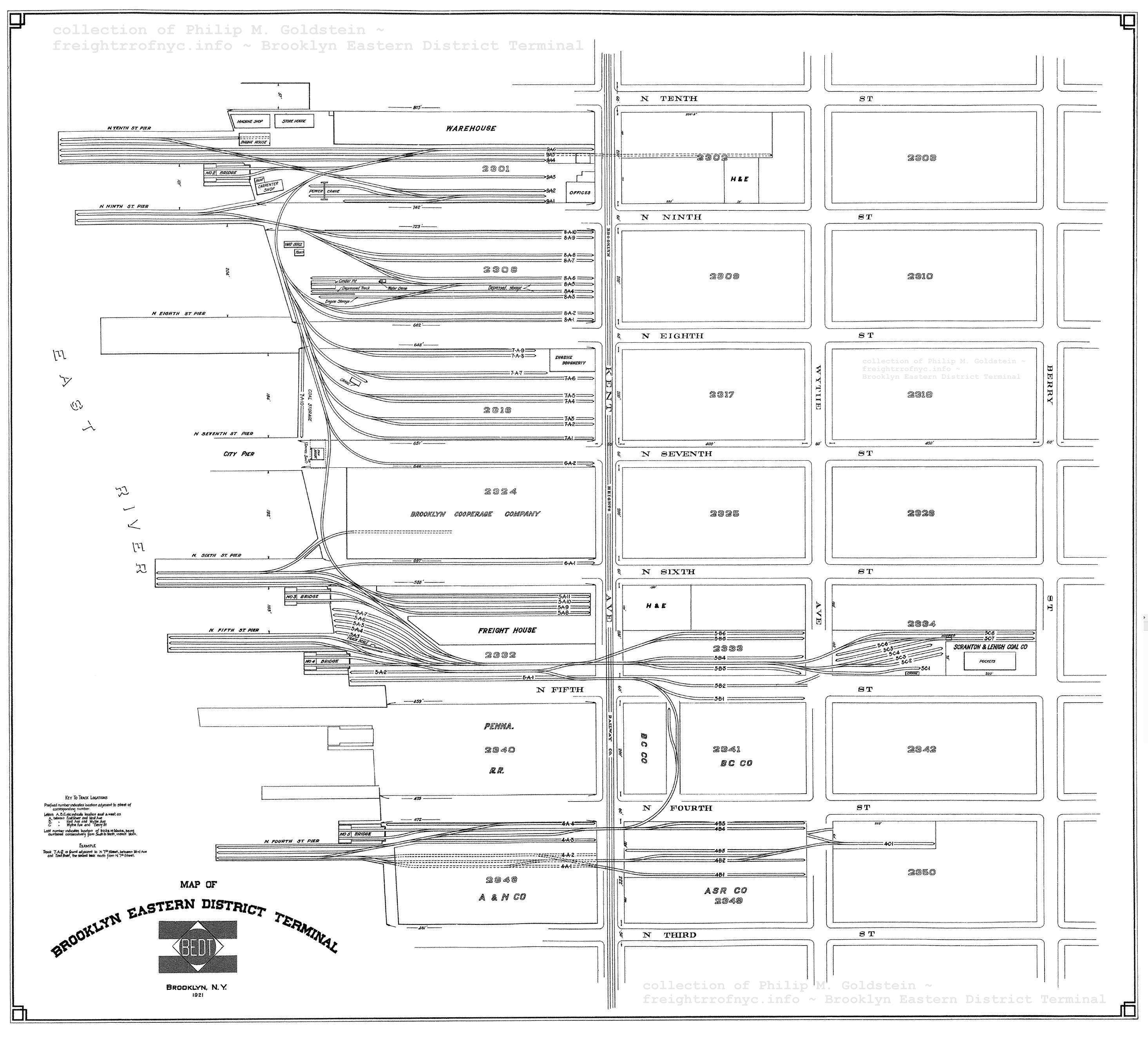
Brooklyn
Public Library Digital Archives
Office of Terminal
Engineer (BEDT) - 1962
Tom Flagg furnished several maps to me, upon a research get together we had on 10 June 2009. The maps I received pertaining to the Brooklyn Eastern District Terminal were especially important, as they were issued by the Office of the Terminal Engineer of the Brooklyn Eastern District Terminal.
What this means is, these are maps of the railroad and property issued and revised by the railroad; and not an independant source as would be the Army Corp of Engineer Port Terminal Series issues or Property Maps.
When a track or structure revision took place, it was noted on these maps. Therefore, these maps are considered to be of the highest accuracy out of any of the other map issues on the website.
This last revison date for the issue here April 1962. Please click on the image below to view a large scale high resolution version. This large scale version is quite big, so please be patient while it opens. Use the back arrow on your browser to return you here, as there is no link to return you to this page.
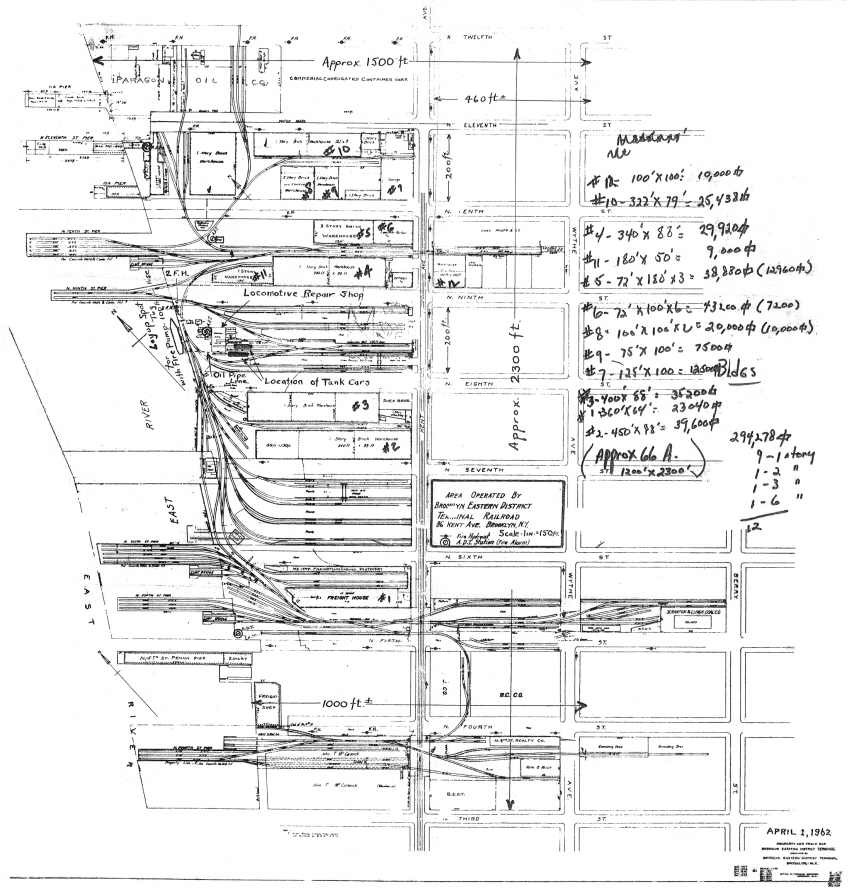
1962 - Office of Terminal Engineer (BEDT)
courtesy of T. Flagg
added 13 June 2009
Office of Terminal
Engineer (BEDT) - 1969
As with the 1962 version above, Tom Flagg furnished this beauty (among others) to me upon a research get together we had on 10 June 2009. The maps for the BEDT were especially important, as they were issues by the Office of the Terminal Engineer of the Brooklyn Eastern District Terminal.
What this means is, these are maps of the railroad and property issued and revised by the railroad; and not an independent source as would be the Army Corp of Engineer Port Terminal Series issues or Property Maps. When a track or structure revision took place, it was noted on these maps. Therefore, these maps are considered to be of the highest accuracy out of any of the other map issues on the website.
This last revision date for this issue is December 1969. For the time being, this is the most recent (latest) revision date we know of, even though BEDT still operated until 1983.
This map is probably the most useful out of all the maps, as the track designations (5A2, 8P1, etc.) are mostly legible as are the structure dimensions. I intend to work with Joe Roborecky to make those designations that are currently illegible, readable once again. So if that is what you desire, a "cleaned" version of this map is available and viewable in the next chapter below.
Please click on the image below to view a large scale high resolution version. This large scale version is quite large, so please be patient while it opens. Use the back arrow on your browser to return you here, as there is no link to return you to this page.
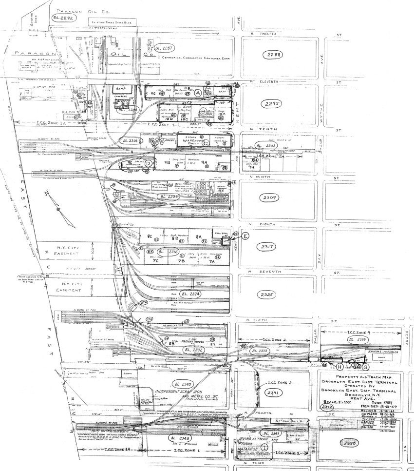
1969 (unedited) - Office of Terminal Engineer (BEDT)
courtesy of T. Flagg
added 13 June 2009
Office of Terminal
Engineer (BEDT) - 1969 (cleaned)
This map, is a cleaned up and slightly larger (150%) version of the original above for better legibility. This version better shows the track designators, construction materials, dimensions and usage of the structures. Some of the track designators, where illegible on the 1969 map, were referenced from the 1962 version; so in actuality this "cleaned" version is the combination of both 1962 and 1969 maps.
Operational notes from Joe Roborecky (retired BEDT locomotive engineer) are included. Locations and markings for city sewers, drainage culverts and other underground items were removed.
Please click on the link below to view this map. Like the others above, this version is a large file size, so please be patient while it opens. Use the back arrow on your browser to return you here, as there is no link to return you to this page.
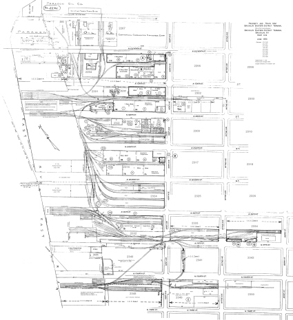
1969 (cleaned) - Office of Terminal Engineer (BEDT
courtesy of T. Flagg
added 13 June 2009
Track Map North
5th Street
Vicinity - ca. 1980
Below is a track map of the North 5th Street vicinity, provided by Joe Roborecky.
This map is essentially a close up of the North 5th Street "A" Yard (#135, #136 and #137 in the Port Series map of 1965), and appears to be copy of the 1969 Terminal Engineer Map shown above.
The origin of this map is and interesting backstory. Independent Scrap was seen moving gondolas in their yard with a payloader. This was not supposed to occur as it prevents engineers from earning their wages. Therefore, a grievence was filed to BEDT management by a BEDT engineer. This initial claim was subsequently denied by BEDT management.
Upon that, the Brotherhood of Locomotive Engineer appealed the denial to the highest designated officer on BEDT, and this was denied. Then BLE took this matter to the National Railroad Adjustment Board to establish a Public Law Board on the BEDT Property. The carrier and union then select a neutral member from a provided list and a three person board is established. This board consists of one carrier member (i.e.: BEDT officer, in this case Mr. Van Grace who was director of employee relations BEDT/NYD); a union member (i.e.: an employee or union representative: Mr. Joe Crawford int'l vp of BLE), and the neutral member (Mr. T. H. O'Brien).
The carrier and union make submissions to the Public Law Board neutral member containing their reasons why decisions should prevail in their favor. Upon that, the neutral member issues a decision. This map was part of the BEDT Officer's submission showing the location of Independent Scrap and their property, and had to be furnished to the neutral member and likewise the union board members, of which Joe was one. Just for closure purposes, the Public Law Board neutral member found in favor of the engineers.
This map, which appears almost identical to the 1969 BEDT Terminal Engineer Map seen above and even appears to be a copy of same, yet contains some minor but significant differences in track designations: track 5 A 11 (1969) vs. track 5 A 10 (1980).
Why this is, is not known, but if we were to hazard a guess, there might be subsequent revision issues after the 1969 Terminal Engineer Map, which have not yet surfaced.
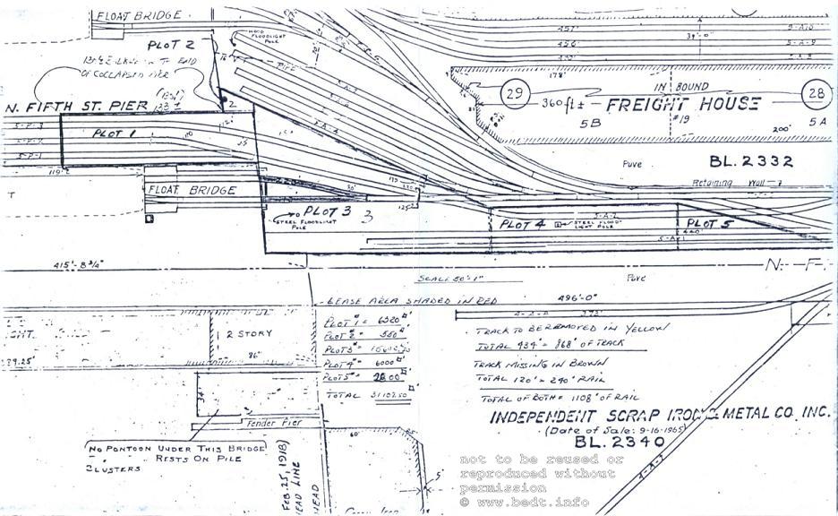
ca. 1968 - Track Map:
North 5th Street
and bulkhead
North is up.
If one takes note, you can see a segment of the diagonal track "4-A-7" at the bottom of the map, which was the track for Independent Scrap on the former site of the Pennsylvania Railroad's North 4th Street Terminal.
Kent Avenue
- South
3rd Street
Very little was known about this yard or published until now.
After referencing several maps, both E. Belcher Hyde (property) and Port Terminal (trackage), no trackage is shown in either. However, it is very clearly stated in the June 1952 issue of the Railroad Magazine article "Railroad Across the River", written by Melvin Krampf; in where it says:
"There is a smaller yard at Pidgeon Street, Long Island City, car capacity 100; another at South Third Street, capacity 100, ..."
Also located in the February 1964 edition of International Thomson Transport Press, (the publisher of the "Official Railway Guide") is an advertisement of the "Union Freight Terminals (BEDT) In New York Harbor" and it lists South 3rd Street Terminal. (see below - circled)
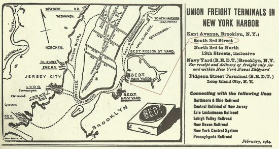
Coincidentally,
the Domino Sugar
Refinery is located at this specific location. As to the service
dates
for this particular yard location, they are unknown but according to
the
article, it was in service in 1952 and listed in the 1964 advertisement.
Later Domino Sugar freight interchange, would consist of station carfloats being moored directly to the bulkhead and loaded / unloaded in the empty boxcar / bridge method as described below in BEDT Memoirs - Domino.
Thanks to Tom Flagg, in furnishing a "Report on Present Operations and Future Prospects of the Brooklyn Eastern District Terminal, dated May 11, 1956; clarifies the use of the "South 3rd Street Yard":
"At South 3rd Street, Brooklyn, the plant of the American Sugar Refinery is served by a dock-to-float loading operation and is classified as a yard for tariff purposes."
Therefore, as it is now understood that the so called "yard" at South 3rd Street, was not a railyard per se; but a dockside mooring location of carfloats with a capacity of 100 cars (i.e.: average 5 car floats x 20 cars each = 100 cars).
In July 2026, this image surfaced in the Digital Collections of the New York Municipal Archives, dated November 19, 1965. With it, we can clearly see and confirm that the Domino Sugar bulkhead was in fact used as a "direct carfloat service" location for the transfer of freight to / from the sugar refinery. Note the covered walkway between the building to the carfloat at rear of carfloat.
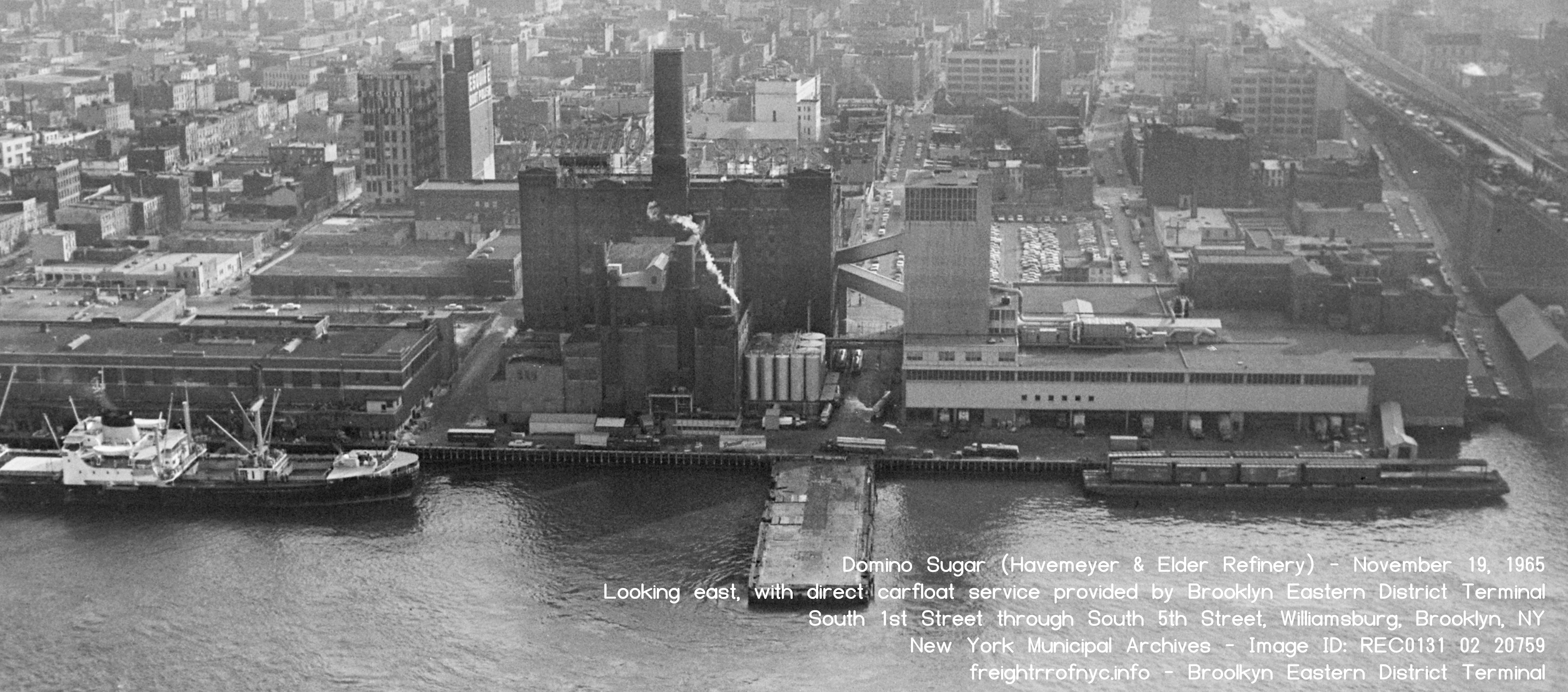
Domino Sugar Refinery - South 1st through South 5th Streets - November 19, 1965
Looking east.
New York Municipal Archives - Image ID : REC 0131 02 20759
Department of Records and Information Services (DORIS)
added 23 July 2026
.
.
|
|
Palmer's Dock
also constructed a
railyard located at Pidgeon Street in the Long Island City section of
Queens. However "small" this yard actually was, (and not accurately represented in the 1929 Belcher Hyde map below), this yard would see a great deal of traffic from the customers located here (see list below). The Pidgeon Street property consisted of 160 acres on the north side of Newtown Creek. By the way: Pidgeon spelled in this particular case (with the 'd') is the correct spelling for this thoroughfare and not spelled conventionally, i.e.: "pigeon". Both the Brooklyn Eagle and the New York Times carried an article, (see images left and right) announcing the purchase of the Pidgeon Street property in June of 1899. Apparently, when Lowell Palmer purchased the property, there was a partnership deal between the Long Island Railroad and himself. |
. |
|
Not only that, but there apparently was a joint LIRR /
Palmer's Dock plan to develop the freight depot that was to be
built at that location.
Nothing more is ever mentioned of the Long Island Rail Road / Palmer association in later years however and as it being well documented, the Long Island Rail Road would transfer freight through their own Long Island City / 21st Street Street float bridge facility & yards.
What is particularly interesting in the New York Times Deed
Transfer announcement (seen to the right), is the mention of "warfare"
between the Pennsylvania Railroad and Palmer's Dock. |
|
The railyard itself would open in 1906, one year after Lowell
Palmer left the operation to the Havemeyer's, and the same year the
Brooklyn Eastern District Terminal name was established.
The primary customer in the beginning would be the New York Sugar Refinery, which would in time become National Sugar, the manufacturer of the "Jack Frost" brand of sugar. National Sugar was part of the Havemeyer sugar holdings.
In later years, the Brooklyn Eastern District Terminal and
this yard would go on to service a Daily News newspaper printing plant,
a beverage distributor, and other smaller industries. |
1898 - Queens "Red Survey" Map 21 - Pidgeon Street / 55th Avenue
.
Proving that there is alway something out there to be found, this map is found online in July 2026. It is part of the series of waterfront surveys for the City of New York and held in New York Municipal Archives digital repository.

1898 - Queens "Red Survey" Map 21 - Pidgeon Street / 55th Avenue
North is up.
New York Municipal Archives - Image ID: REC0133 1 1128
Department of Records and Information Services (DORIS)
added 23 July 2026
.
The following is a 1919 E. Belcher Hyde property map of the Pidgeon Street area. This is the earliest property map I have been able to locate online of the area thus far.
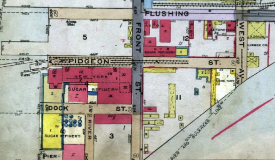
E. Belcher Hyde Map, 1919
North is up.
.
..
The following image is a Fairchild Aerial Survey Photo dated 1924. While the shadow of the National Sugar Refinery building hides the trackage running down the portion of Pidgeon Street west of Front Street, it does show that trackage did not yet extend east of West Avenue. The float bridge and finger pier can be see to the left of the building shadow.
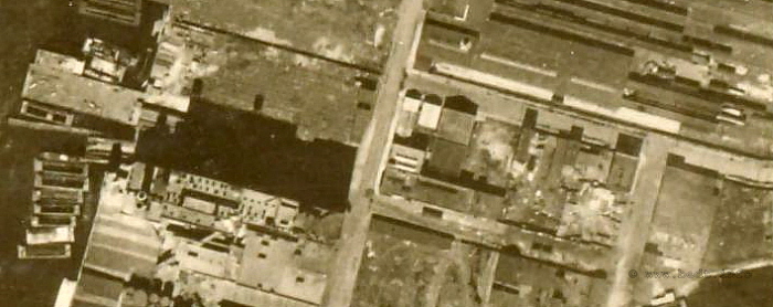
1924 - Fairchild Aerial Survey Photo
NYPL Digital Archives
added 31 May 2009
.
The following oblique aerial is dated November 19, 1965, and believed to be taken by Air Map Of America Corp.; a firm in the same line of work as Fairchild Aerial Surveys. With Fairchild ceasing operations in 1965, Air Map would pick up the business. Click on the image below for a high resolution version.
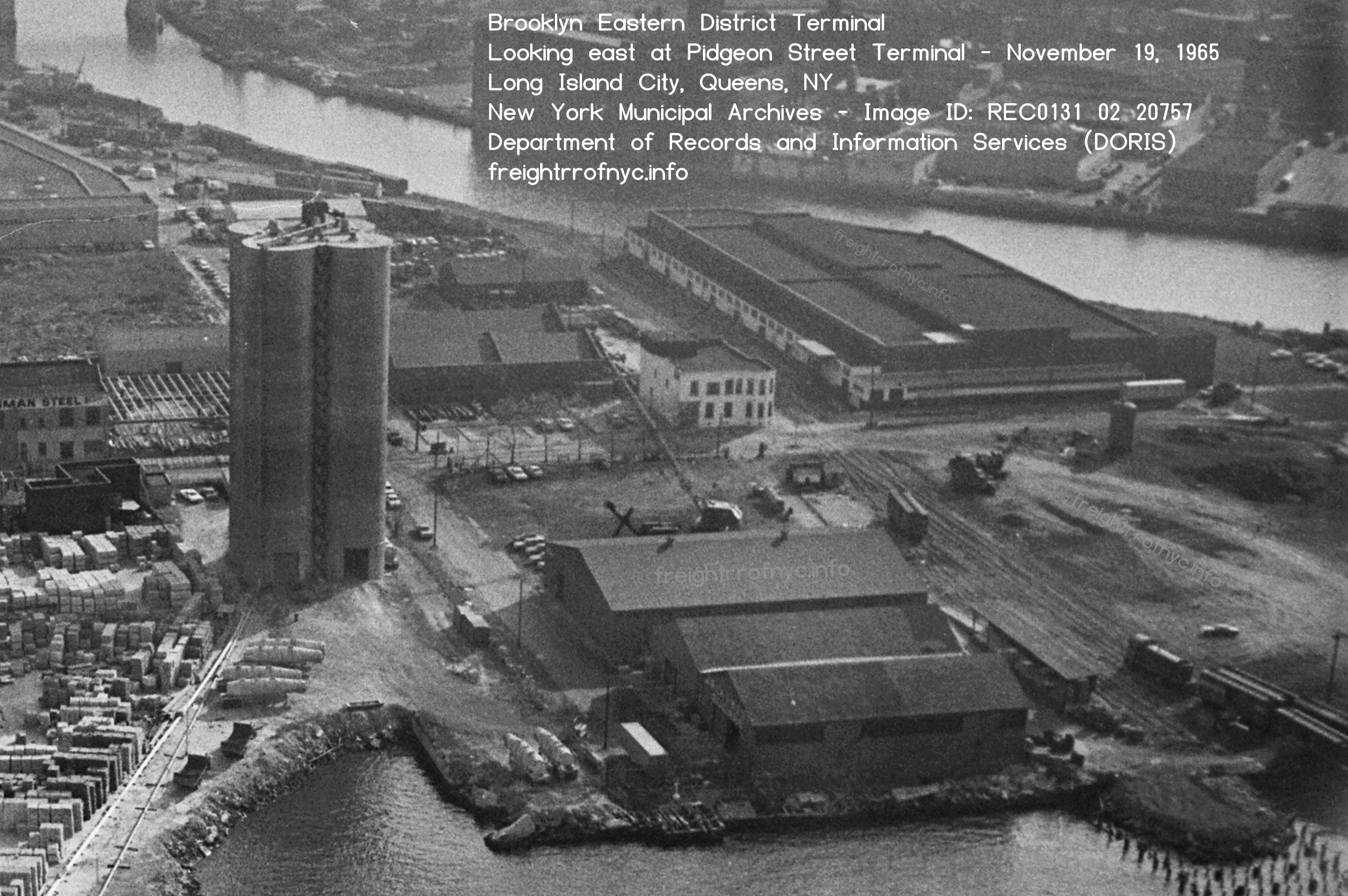
Pidgeon Street - Long Island City, Queens, NY - November 19, 1965
Looking east, Newtown Creek on right.
Air Map of America Corp.
New York Municipal Archive - Image ID: REC 0131 02 20757
added 23 July 2026
.
This next image is the 1932 Series of Corp of Engineers Port Terminal Map. It is currently the earliest Port Map located to date of the Pidgeon Street Yard..
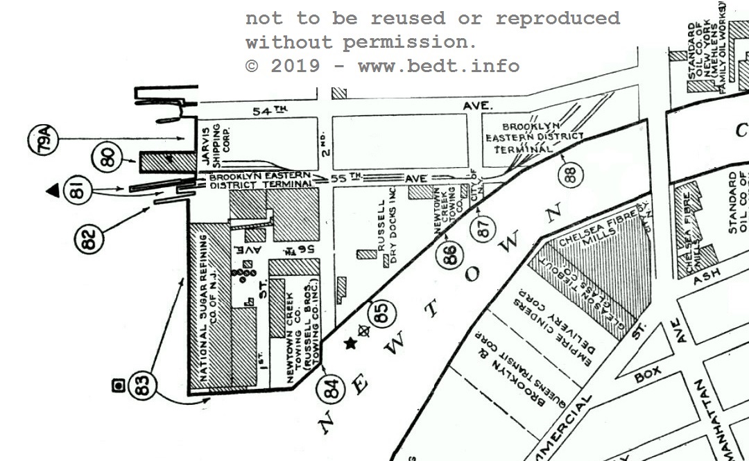
Pidgeon
Street, Long Island City, Queens, NY;
1932 edition
Port Facilities at Port of New York - Office of the District Engineer
New York District, Corp of Engineers
East River / Newtown Creek, Long Island City & Brooklyn, NY
(Map 47)
North
is up.
University of
Missouri–St. Louis Digital Archives
authors collection
added 19 April
2019
The following map of the Pidgeon Street Terminal is from the 1942 issue of the Port Facilities at Port of New York - East River / Newtown Creek, Long Island City & Brooklyn, NY. It shows the track arrangement after the trackage was expanded east. (Front Street has been renamed 2nd Avenue and while unmarked, West Avenue has been renamed 5th Street likewise Dock Street is now 56th Avenue. Pidgeon Street (misspelled on the map no less) has become 55th Avenue and Flushing Avenue would become 54th Avenue yet retain both names on later street atlases).
Two blocks inland (east) from the East River, the Pidgeon Street Yard was located directly across the street (54th Avenue / Flushing Avenue) from the Long Island Rail Road yard. As close (approximately 80 - 100 feet) as these two yards would be located to each other, (and like the PRR North 4th Street yard located on Kent Avenue), the BEDT and LIRR never were nor ever would be physically connected.
.
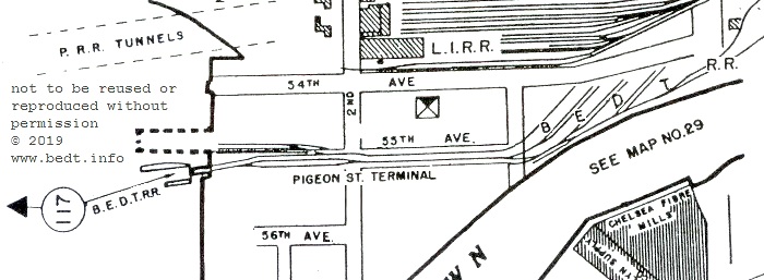
Pidgeon Street, Long Island City, Queens, NY;
1942 edition
Port Facilities at Port of New York - East River / Newtown Creek, Long
Island City & Brooklyn, NY
North
is up.
authors collection
added 19 April
2019
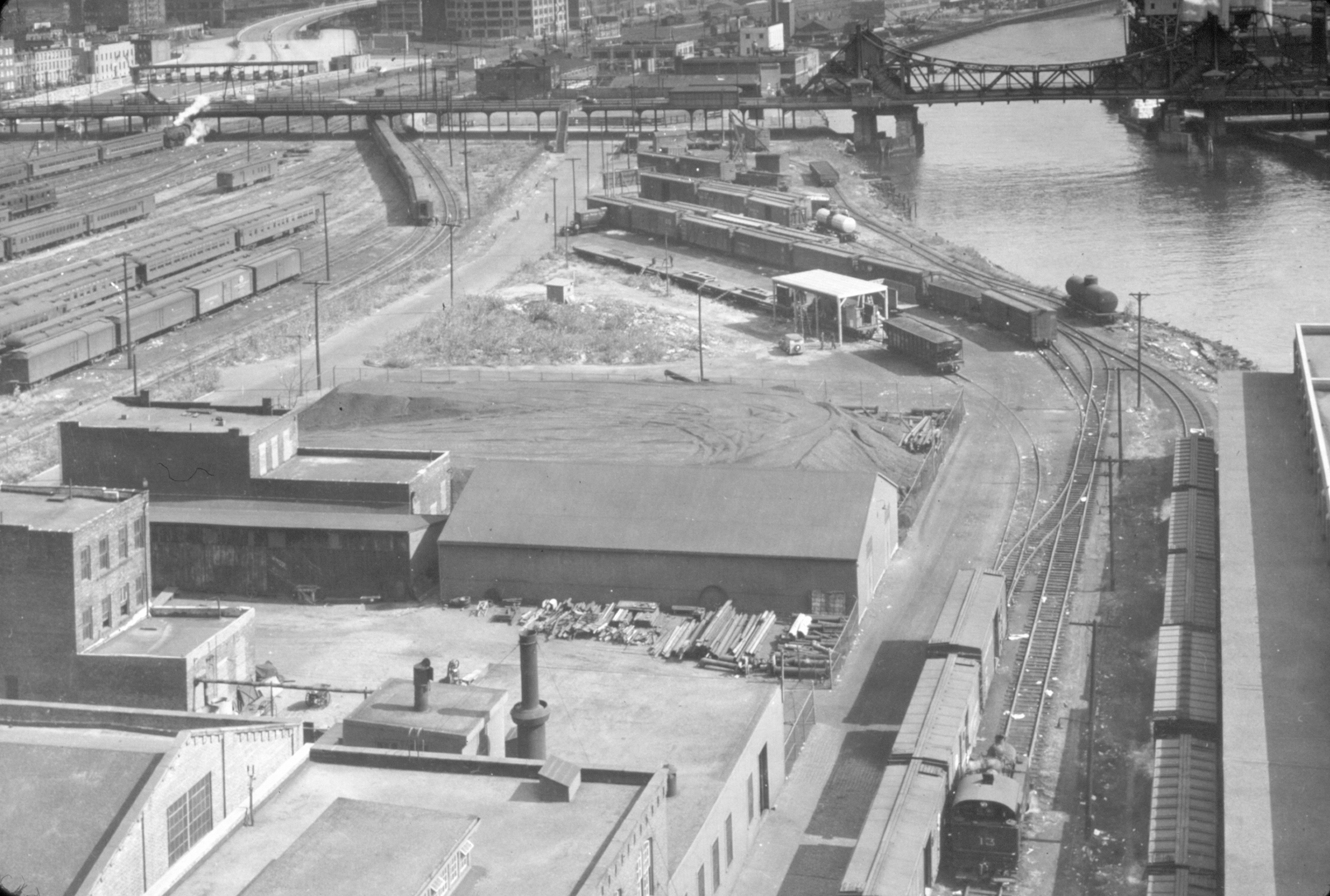
.
Without a doubt, two of the finest photos of the Pidgeon Street Yard of the BEDT! Obviously taken from one of the upper story windows of the Jack Frost Sugar Refinery, looking east. Several interesting facets of this photo include:
Acquired several months later, is the companion photo to the image above. Taken the same day, this image is zoomed in on the yard, and shows some slight differences: Another gondola has been placed by the coal co, another truck is unloading from a freight car, and the Vernon Avenue drawbridge is raised to permit a tugboat to transit.
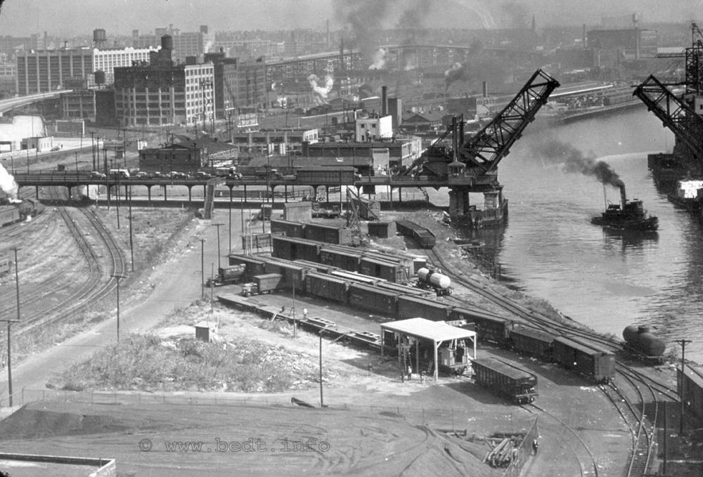
Pidgeon
Street Yard - October 11,
1943
Looking east. Tracks on left edge are Long Island Rail Road.
There was no connection between LIRR and BEDT.
W. J. Madden photo
authors collection
added 22 February 2011
.
The following image; dated 1951, looking west and while rather grainy; shows the the BEDT Pidgeon Street Yard, which still closely conforms with the 1943 photo above. Note the lack of the covered unloading shelter.
1951 - Pidgeon Street
Looking west. Newtown Creek in foreground, East river behind buildings.
Fairchild Aerial Survey
Map
NYSPL Digital Collections
added 31 May 2009
According to the
Coverdale
& Colpitts Report,
freight traffic destined
for Pidgeon Street customers was not directly received from other
carriers
and terminals at the Pidgeon Street float bridge, but in fact had to go
through
the Kent Avenue Yard first. It was here that inbound cars
destined for
Pidgeon Street were pulled from inbound carfloat, sorted, classified,
reblocked and loaded upon a carfloat for Pidgeon Street.
One of recommendations that the Coverdale & Colpitts Report makes to the Brooklyn Eastern District Terminal administration, is for them revise this policy and eliminate handling the inbound freight twice and ship it directly from the mainland Class 1 terminals to Pidgeon Street. From what this author has been able to gather, this recommendation was not heeded, and the Brooklyn Eastern District Terminal continued "doing things their way".
In discussing this policy with Joe Roborecky, he makes a valid point: no matter where the Pidgeon Street traffic was sorted, either at Pidgeon Street or Kent Avenue, BEDT would would have to handle the freight cars twice. As the Class 1 railroad's simply forwarded all freight cars destined for the Brooklyn Eastern District Terminal, it was not the Class 1 railroads' responsibility to sort the Brooklyn Eastern District Terminal's cars according to BEDT's individual terminals, in those respective Class 1 yards in New Jersey (unless of course the BEDT was willing to pay the Class 1 railroads to do this).
As not all freight cars for BEDT were destined for Pidgeon Street, and as Pidgeon Street traffic would be coming from a multitude of Class 1's (CRRNJ, WS, NYC, PRR, etc), it would not be economically feasible to load only those one or two cars from that particular Class 1 railroad onto a carfloat specific for Pidgeon Street, then transfer that carfloat to the next Class 1, load their two or three cars, so on and so forth.. So, it was simpler, cost effective and less labor intensive to send everything to Kent Avenue (which had the room to classify the cars whereas Pidgeon Street did not) and let BEDT crews sort out the traffic according to desitnation (Pidgeon Street, Wallabout Market Terminal, Brooklyn Navy Yard, etc).
According to both the New York Central Railroad Terminal Facilities in the Port of New York Map of 1943 and the 1965 Port of New York Authority Harbor Terminals Map, the Pidgeon Street Yard was "Car Load Delivery" only.
All things considered, the Pidgeon Street location would have the second longest lifespan (next to the original Kent Avenue, North 5th through North 9th Street yards) and the Pidgeon Street Terminal would close permanently in 1977 (possibly 1978). As of July 2008, the Pidgeon Street float bridge is the only surviving float bridge of the BEDT. Please refer to Surviving Float Bridges section in the Float Bridges chapter, to view images.
.
The
"second" Pidgeon Street Float
Bridge
In September 2009, Dave Keller sent over a photo from a recently acquired collection. It is a unique photo of the Pidgeon Street float bridge to say the least. The reason for this being, the Pidgeon Street float bridge was not photographed as often as the float bridges at Kent Avenue would be. A few days later; Joe Roborecky, in his usual pursuit of detail; noticed that the float bridge in the 1958 photo is not the same float bridge as the float bridge in the photos I took in July 2008!
Compare for yourself:
|
|
| . . |
|
|
.
Based on this new photographic evidence; it is now apparent that the Brooklyn Eastern District Terminal found it necessary to replace the Pidgeon Street float bridge. This replacement obviously took place between 1958 and 1976, when that location was taken out of service.
Both Joe and myself have compared photos of the float bridges located at Kent Avenue to determine if any of those float bridges were relocated to Pidgeon Street. Of the other Kent Avenue float bridges that were "surplussed" due to downsizing of operations, i.e.: North 5th Street - (a pony plate girder) and North 3th Street - (pony truss with tapered ends and small diagonal brace gusset plates), neither matches the design of the second Pidgeon Street float bridge seen above. As North 9th and North 6th Street float bridges remained in service until 1983, they therefore could not have been relocated to Pidgeon Street.
Therefore, it currently remains undetermined from whom or where this "second" Pidgeon Street float bridge was obtained from or whether it was constructed new, as well as the reason for the replacement. It is a safe (but not confirmed) conclusion that if the float bridge in the 1958 photo is in fact the original float bridge installed at Pidgeon Street when the yard opened in 1906, it was definitely nearing the end of its service life by 1958, as research of other facilities shows most steel float bridges in the New York Harbor area were changed out around the fifty year mark.
Pidgeon Street would be renamed 55th Avenue, and the thoroughfare cease to exist all together when the area was reconstructed circa 1980's.
The float bridge seen in the 2008 image above sat undisturbed until 2017, at such time it vanished and is presumable scrapped.
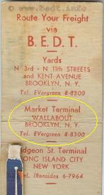 |
On the inside cover of the BEDT matchbook I own, the Brooklyn Eastern District Terminal lists a facility - a "Market Terminal" at Wallabout, Brooklyn NY. The phone number listed is the same for Kent Avenue. Quite honestly, until "reading" this matchbook, I forgot about this terminal. The BEDT would be the last and shortest lived terminal to occupy the Wallabout Market area.
In December 2008, Joe Roborecky located the following Port of New York Authority New York Harbor Terminals Map from 1940. This map shows us the locations of the various terminals and stations in the Wallabout Basin with a great degree of clarity, including the Brooklyn Eastern District Terminal's Wallabout Market Terminal.
The "Wallabout Market Terminal" of the Brooklyn Eastern District Terminal. This map shows that the Wallabout Market Terminal of the BEDT was Car Load Delivery Only (partially filled red circle) with float bridge. All the other terminals were Car Load and Less than Car Load (red triangle) and were actually pier station service, with no trackage (except for the D. L. & W. facility.)
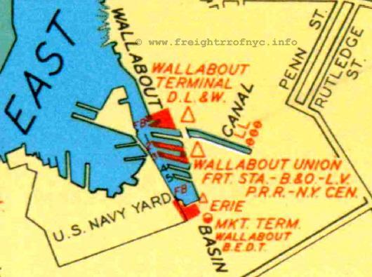
Port of New York Authority - NY Harbor Terminals Map,
1940
North is up. |
The first railroad terminal to take up residence in the Wallabout Basin vicinity was the Delaware, Lackawanna & Western Railroad's Wallabout Terminal, which opened in 1900. A float bridge was installed and a small railyard constructed at this location. Neighboring piers to the south would come to be the "Wallabout Union Freight Station", with Baltimore & Ohio, Pennsylvania, Lehigh Valley and New York Central Railroads occupying several piers. These would be pier stations only, with no trackage or float bridge. South of that and at the very head of the basin, the Erie Railroad would take up residence in "Dressler's Wharf" and offer pier station freight station service. The Brooklyn Eastern District Terminal would not gain access to Wallabout Terminal until 1936. On 13 March 2010, Joe Roborecky found this gem online:
|
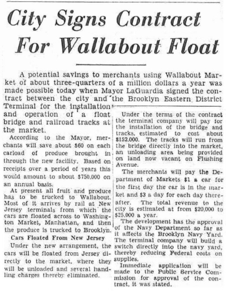 |
This is a very interesting article as it not only contains the arrangements of Brooklyn Eastern District Terminal with the City of New York, as well as the cost of the float bridge installation.
On 21 March 2011, I received yet another "care package" from Jon Franz. Over the past several years, Jon has been generously sending to me various images, documents and "what have you" pertaining to many of the offline terminals covered in this website. Jon has always sent great material and this package was no exception.
In this envelope was an original printed and bound Contract between the City of New York and the Brooklyn Eastern District Terminal dated November 16, 1935. This Contract (bound in a page booklet form with attached fold out map) specifies the details of the Brooklyn Eastern District Terminal Wallabout Market, including such information as: length of contract, preferred operating times, who shall furnish lighting, responsibility and maintenance of the trackage, float bridge construction, etc.
I strongly urge you to click on the following map, which will take you to scans of the contract booklet where you will be able to read the details of that contract, as well as a large scale version of the included map. Scans of the New York Times newspaper front page article of May 3, 1936 covering the dedication ceremony can be seen as well. A link at the bottom of the page will return you here.
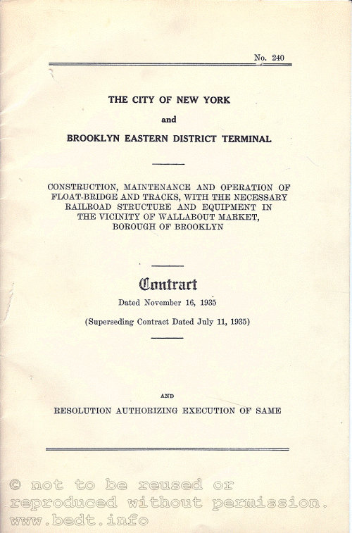
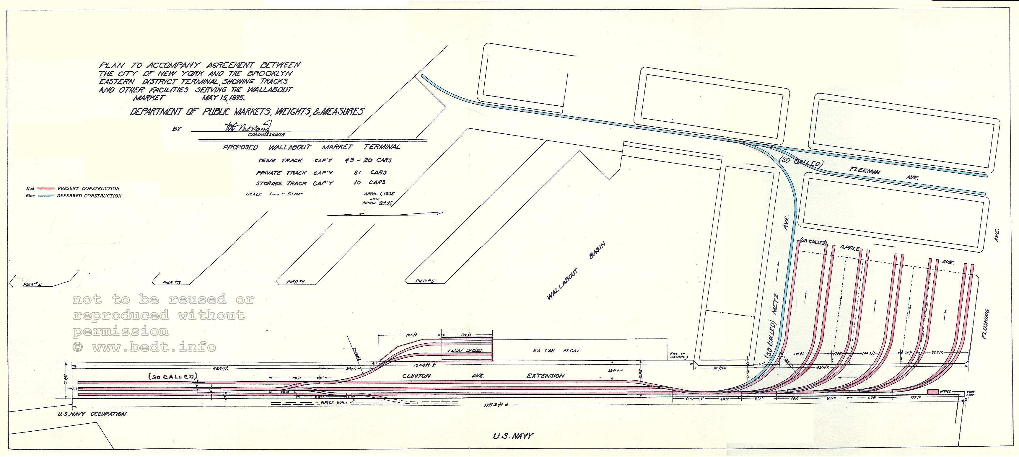
As seen in the map above, which is a fold out adhered to the back cover of the contract, we can now understand that the City of New York razed the market stalls / structures bounded by Apple, Clinton, Flushing & Metz Avenues. Following this demolition, it is now apparent the Brooklyn Eastern District Terminal installed team tracks at this location, so that vendors could sell their applicable produce directly from the boxcar doors.
This makes sense, because as stated in the Contract, the Brooklyn Eastern District Terminal was to make all effort to perform switching while the Market was idle, which was between the hours 4 p.m and 4 a.m. (winter) and 4 p.m. to midnight (summer). This no doubt required the BEDT to schedule a "night trick" to switch the Wallabout Market Terminal, of which we already know the Brooklyn Eastern District Terminal was already equipped to do so as it operated around the clock.
Also of particular interest, is the fact that some of the trackage is shown as "deferred" (shown in blue). At this time it is not known why construction of this trackage was put off or whether it was even constructed. The alignment of this deferred trackage shows it to be laid on the west side of Fleeman Avenue, and thereby closer to the market stalls / structures (than to the piers on the east side of Fleeman Avenue). Therefore the trackage appears to have been intended to provide service for those market stalls bounded by Fleeman Avenue, D Street, Washington and Metz Avenues.
It should be taken into consideration that this track shown along Fleeman Avenue would have passed in front of most of the bulkhead and piers occupied by the Class 1 railroads which composed the Wallabout Union Freight Terminal (Erie, Baltimore & Ohio, Lehigh Valley and New York Central Railroads). It is left to postulate whether the competitive Class 1 railroads mentioned, might have opposed this deferred trackage as it undoubtedly would have given the BEDT an advantage in that it would be able to deliver the freight car right to the door of market stalls.
Jon
Franz took the time to put together a timeline
of the Wallabout Market which I include
here:
.
| October 1884 | Wallabout
Market established by the City of Brooklyn,
on land leased from the Federal Government adjacent to the New York Naval Shipyard (a/k/a Brooklyn Navy Yard) |
|
| November 1891 | Wallabout Market property sold by the U.S. Government to the City of Brooklyn. | |
| 1894-1896 | Permanent structures for Wallabout Market incorporating a Dutch look designed by William Tubby, are erected. | |
| ca. 1900 | Wallabout Market recognized as the largest wholesale produce & processed food market in the United States. | |
| 18 January 1935 | New York Department of Docks authorizes establishment of a freight terminal to directly serve Wallabout Market. | |
| 16 November 1935 | Agreement
signed between the City of New York and the
Brooklyn Eastern District Terminal, whereby the BEDT will construct and operate a float yard and team tracks to serve the Wallabout Market. |
|
| 02 May 1936 | BEDT freight terminal "Wallabout Terminal Market" opens. Mayor LaGuardia arrives in steam locomotive. | |
| 01 April 1941 | U.
S. Government files "notice of condemnation and
declaration of taking" to appropriate the Wallabout Market property for expansion of Brooklyn Navy Yard. |
|
| 14 June 1941 | Wallabout Market closed for expansion of Brooklyn Navy Yard. | |
| 10 September 1941 | A photograph taken
by R. Wingard on September 10, 1941, shows BEDT #15 operating at
Wallabout Market Terminal. The reason for this discrepancy in dates has not been discovered as yet. |
.
Also included with Jon's packet was a copy of the Sunday, May 3, 1936 edition of the New York Times. The opening ceremony of the Railway Terminal at Wallabout Market garnered front page, including images. One image shows the opening ceremonies and the other image (which is more dramatic to our interests) is of Mayor Fiorello LaGuardia at the controls of BEDT #15. Little Flower always had a flair for the dramatic! As Johnny Carson use to say, "You just can't make this stuff up!"
In October 2022, and with many thanks to Bob Rickey; he located the Brooklyn Times Union image of LaGuardia at the controls of a BEDT steam locomotive in the Wallabout Terminal Market in an edition of the Brooklyn Times-Union!
Mr. Rickey was researching the Wallabout Market for his research and was gracious enough to forward to me applicable newspaper articles and images; of which not only pertained the BEDT operations in Wallabout, but also those of Delaware, Lackawanna & Western's Wallabout Terminal as well as those of Wallabout Union Freight Station (B&O, LV, NYC & PRR) and Erie RR's Wallabout Freight Station. Those documents can be seen on those respective pages of this website.
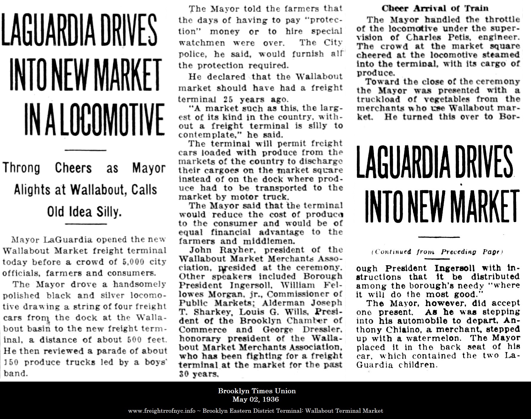 |
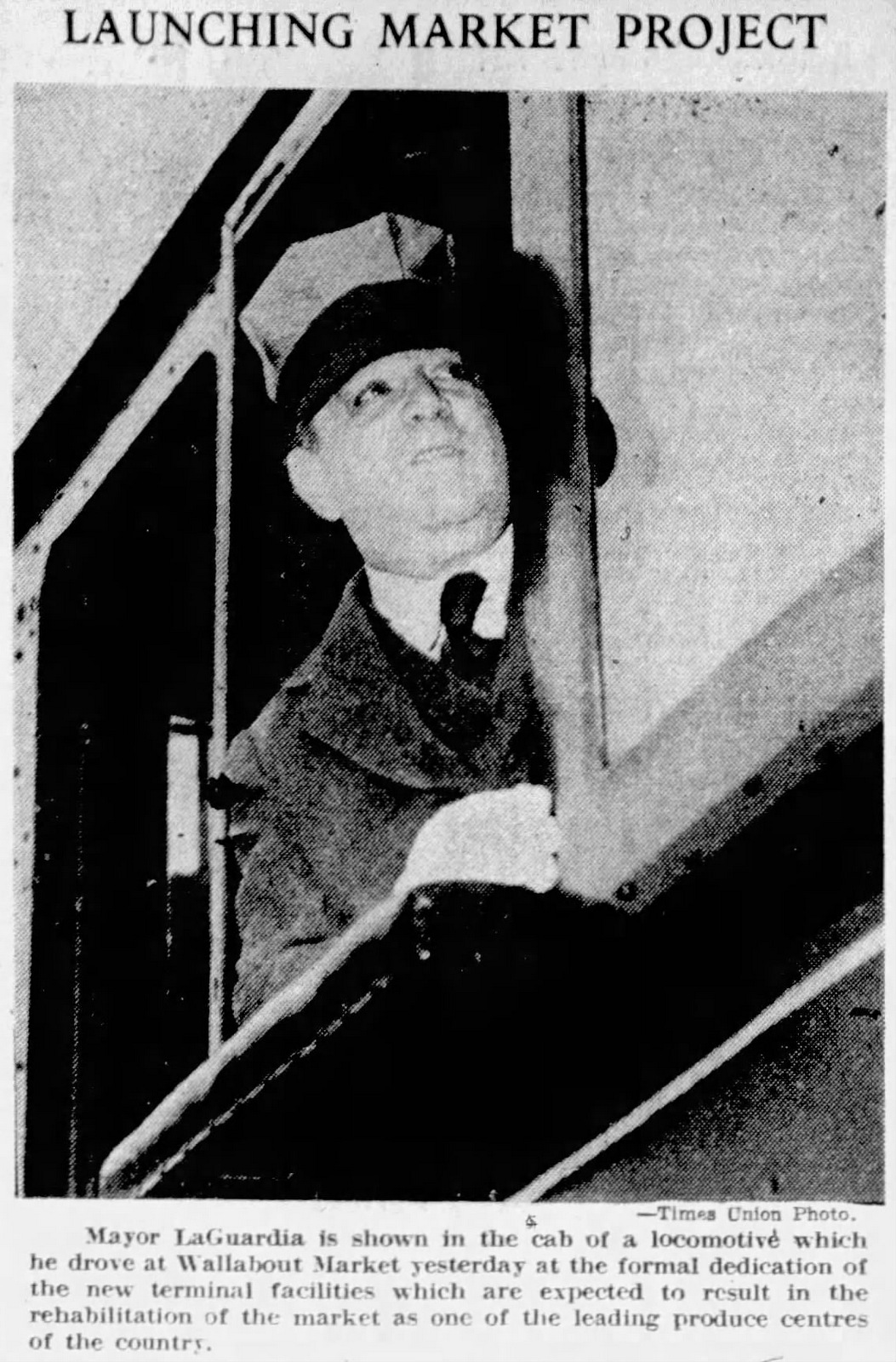 |
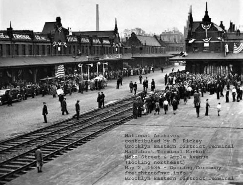 |
|
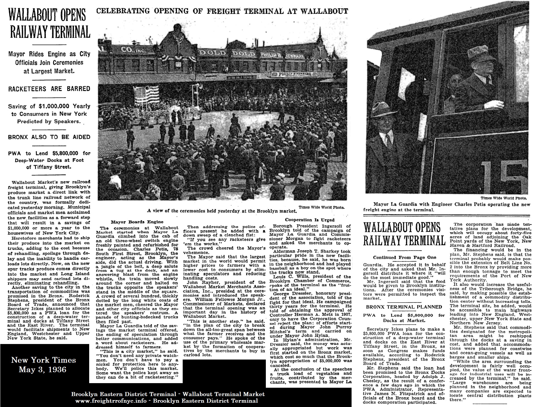
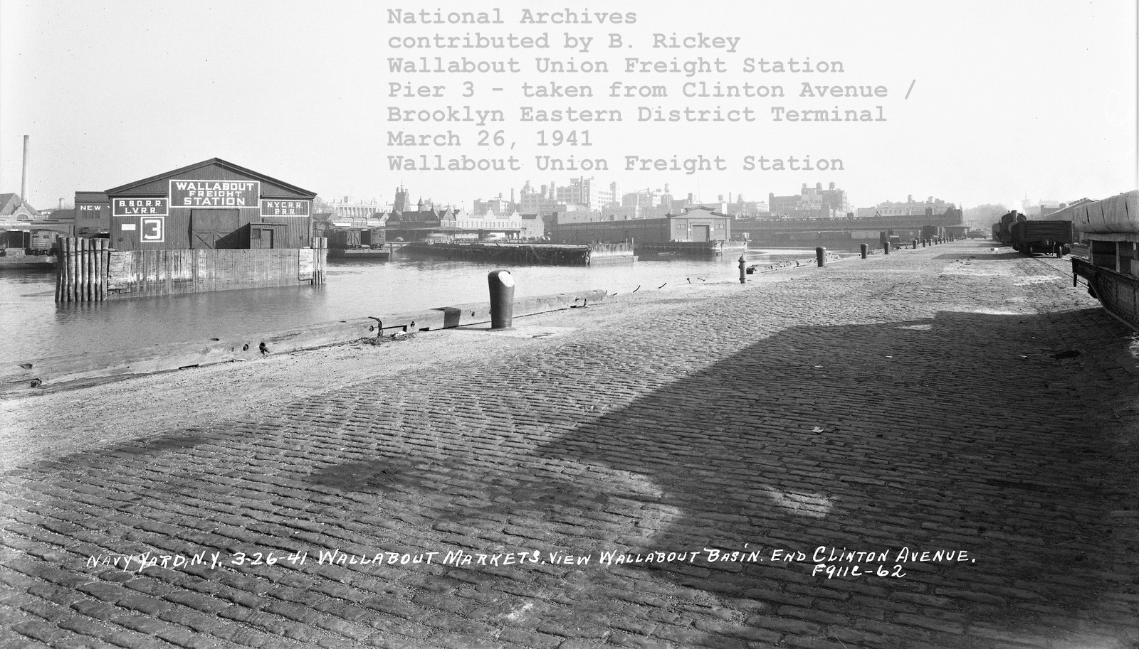
Brooklyn Eastern
District Terminal locomotive (#14 or 15) on Clinton Avenue Extension
(behind gondola) on right edge of image - March
26, 1941
BEDT Wallabout Terminal
float bridge barely visible on bulkhead with carfloat and cars to left
of locomotive
Across basin is Wallabout Union Freight Station Pier 3 (Baltimore
& Ohio / Lehigh
Valley / New York Central / Pennsylvania RR) Pier 4 (open),
Pier 5 Wallabout Union
Pier Station and Dressler's Wharf /
Erie Freight Station.
(see enlargement below)
National Archives
image
forwarded by Bob Rickey
added 30 October 2022
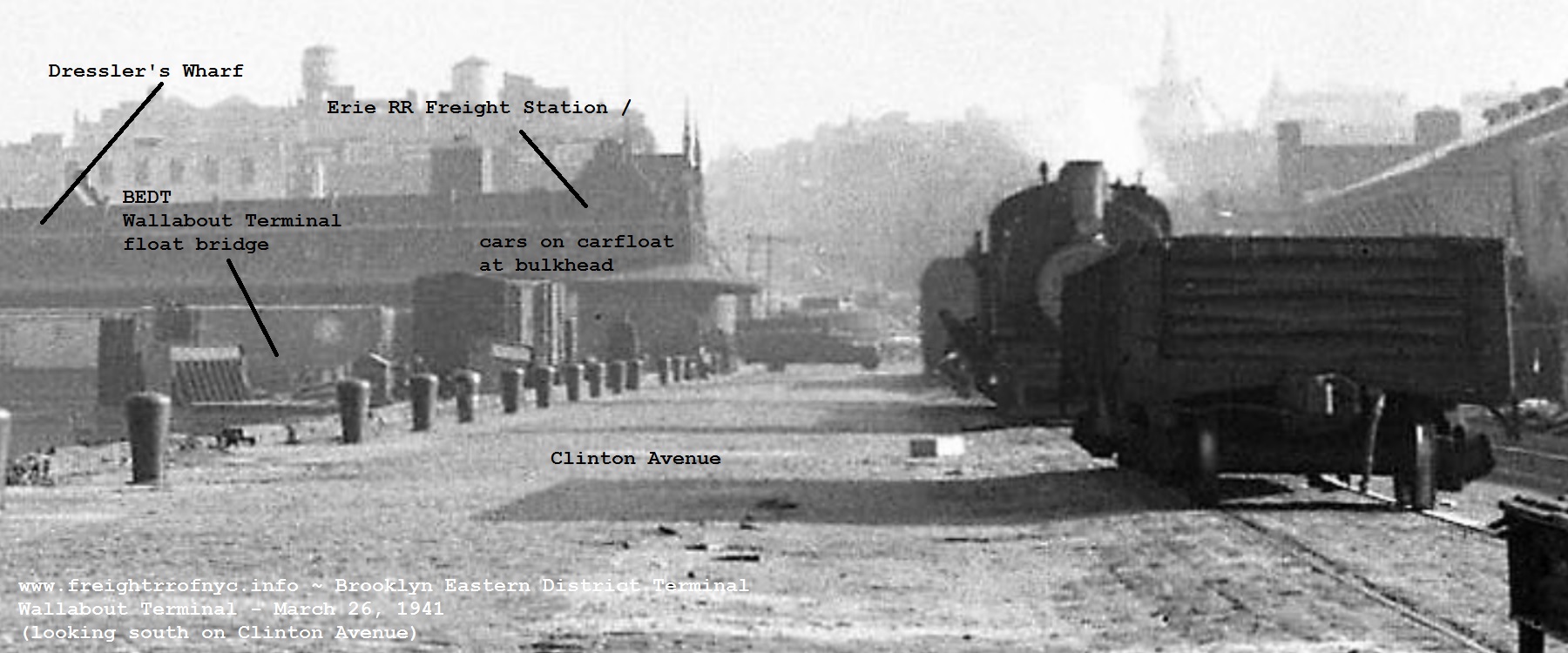
enlargement
of image above: Brooklyn Eastern District Terminal locomotive (#14 or
15) on Clinton Avenue Extension (behind gondola) on right edge of image
- March
26, 1941
BEDT
Wallabout Terminal float bridge (approach apron not yet constructed!)
with carfloat and cars at bulkhead south of bridge apron for direct
unloading.
National Archives
image
forwarded by Bob Rickey
added 30 October 2022
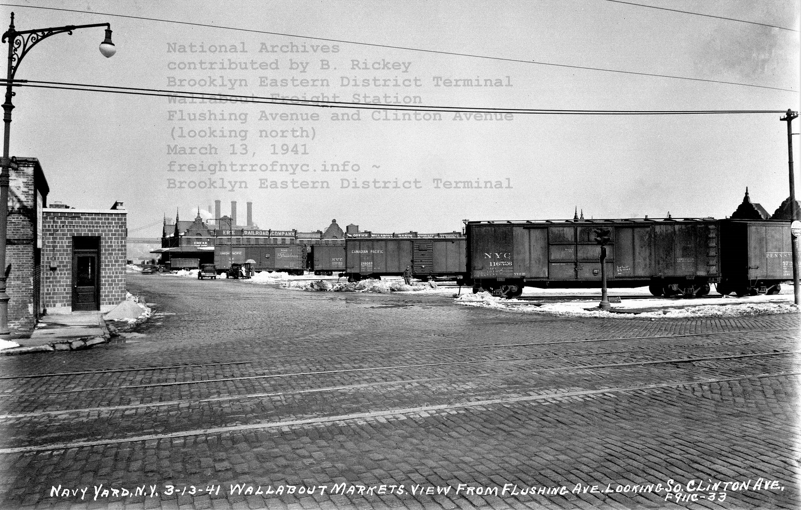
BEDT - Wallabout
Terminal Market team tracks. Clinton Avenue and Flushing Avenue; with Dressler's
Wharf / Erie Freight Station in background -March
13, 1941
National Archives
image
forwarded by Bob Rickey
added 30 October 2022
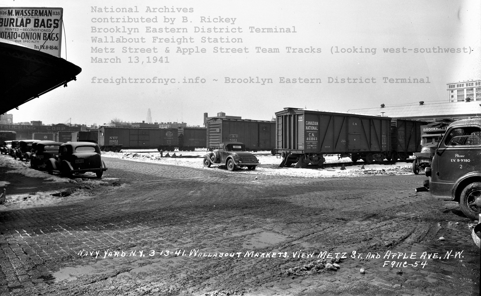
BEDT - Wallabout
Terminal Market team tracks: Metz Street and Apple Avenue (looking
southwest - data on negative in error).
Williamsburgh
Savings Bank skyscraper located in downtown Brooklyn in distance. The
Erie RR Wallabout Freight Station is behind photographer and to right.
White multi-istory concrete building on right edge of image is Navy Yard
Supply Storehouse and General Offices.
March
13, 1941
National Archives
image
forwarded by Bob Rickey
added 30 October 2022
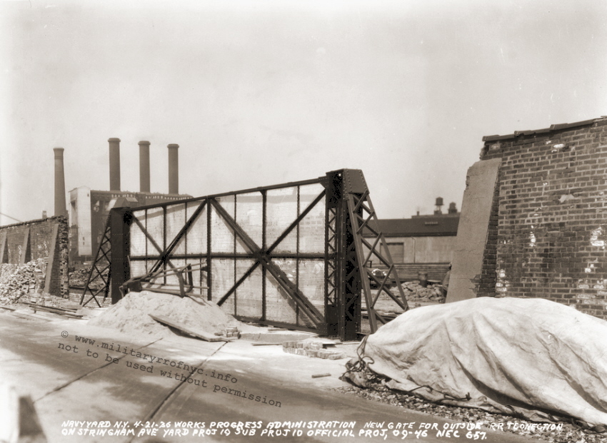
Tom Hendrickson, informed me on August 27, 2007 that he located mention of a 18 page souvenir program for the Official Opening of the BEDT Wallabout Market Freight Terminal on Saturday, May 2nd, 1936 at 10:00 a.m. We are trying to secure an image of the program.
Float Bridge
While we knew the Brooklyn Eastern District Terminal now had presence at the Wallabout Market, where exactly the float bridge at the Wallabout Terminal was actually located remained unknown. After engaging is some lengthy dialog on 06 May 2009 with Joe Roborecky and Tom Flagg, we narrowed down some possibilities as to the location of the BEDT Wallabout float bridge, but still had not been able to determine for fact where it was located exactly.
The very next day, in searching his vast collection of documents, Tom located the following image. It is an inspection report map for the Brooklyn Navy Yard and it is dated July 15, 1940. This map shows the exact location of the BEDT Wallabout Market Terminal float bridge. This report illustration also shows, very nicely, the arrangement of interchange for the BEDT float bridge and trackage in the Navy Yard. Note the connection was through the "terminal gate", as marked. This was a tall wood fence, which can be seen in photos on the Wallabout Union Freight Station webpage.
The presence of this fence makes sense, as it secures the Navy Yard property from Clinton Avenue, which was a public thoroughfare albeit a dead ended one! When this gate was closed, the Navy Yard perimeter would be secure, and allow both pedestrian and vehicle traffic to use the Clinton Avenue bulkhead without compromising the security of the Navy Yard. When opened, it allowed the BEDT to access Navy Yard trackage. It should be noted that this gate entrance and the ability of the Brooklyn Eastern District Terminal to provide service if need be to the Brooklyn Navy Yard was a stipulation of the Contract.
This report also shows that the Brooklyn Navy Yard float bridge was still in place and Tom believes possibly still in use (since there are no notations to reflect otherwise). The only modification I made to this map, was to highlight the fence (in red) separating the Navy Yard from Clinton Avenue & the BEDT trackage.
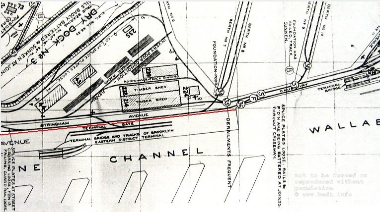
Inspection
Report Map for the
Brooklyn Navy Yard -
July 15, 1940
National Archives, New
York City branch
courtesy of T. Flagg
added 07 May 2009
Trackage
The map below, which is affixed to back cover of the Brooklyn Eastern District Terminal / City of New York Contract, show in great detail the track layout for the Wallabout Terminal Market. You can click on the map below to review a large scale version. Please use the back arrow on your browser to return you here.
East is up, North is left.
J. Franz archives
added 22 March 2011
Before the addition of the aforementioned contract
to this website,
I had contacted and held a conversation with Mr. Ron Ziel in
October
2008. He mentioned a photograph of a BEDT locomotive at the Wallabout
Market
Terminal taken September 10, 1941 in the archives of Frank Zahn. At the
time
of our conversation, neither of us knew that Mr. Zahn had passed away
several
weeks prior. Fortunately, his wife Lillian allowed me to procure the
negative
in question, as well as the remainder of Mr. Zahn offline terminal
images.
From the date written on the negative envelope, we must conclude that the Brooklyn Eastern District Terminal did not relinquish its presence at Wallabout Terminal until sometime after that date.
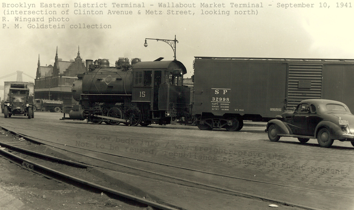
Wallabout Market Terminal team tracks - September 10, 1941
Looking north at intersection of Clinton Avenue former Peach & Pear Streets.
R. Wingard photo
F. Zahn archives
authors collection
added 13 Apr
2009
|
|
|
The structure housing the Erie Railroad
Freight Depot /
Freight House fronted on the eastern bulkhead of the Wallabout Basin as
seen
in the modified E. Belcher Hyde Property Map as tax block 8598
(in pink
and magenta). The modifications to this map consist of sewer &
water
mains removed for clarity. The structures that have been faded out (tax
blocks
2024 on the property map), were razed circa 1935 according to
photographs
in various digital images of New York Area libraries. The property was
left
open, yet paved for the open air market. Just six years later,
even
this newly improved market area was completely upsurped in the
expansion
of the Brooklyn Navy Yard.
In my opinion, this 1941 Wingard photograph is one of the most historically important images pertaining to the Brooklyn Eastern District Terminal. It is, as far as it is known, the only photographic record of a Brooklyn Eastern District Terminal locomotive operating in the Wallabout Market Terminal. As Brooklyn Eastern District Terminal rail service was not long in duration at this location (1935 through 1941), one can understand why this photograph is important.
The photo below shows a Brooklyn Eastern District Terminal tugboat heading out the Wallabout Basin with a loaded carfloat. While the tugboats name cannot be seen, the sideboards on the carfloat are marked Brooklyn Eastern District Terminal. It appears this photo was taken from atop of a boxcar loaded aboard a station carfloat at the very head of the Wallabout Basin where the Erie Railroad Freight Station was located.
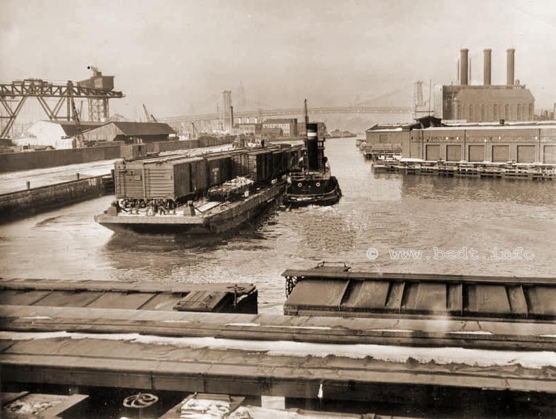
Wallabout Basin - February 1941
added
24 Dec
2008
Closure
The BEDT Wallabout Market Terminal operated until very late in 1941 (sometime between September through November), at which time the remainder Wallabout Terminal property was taken over by the United States Government. The United States Government had declared on April 1, 1941 (in preparation for the United States' entrance into or at least the material support of its Allies in World War II?) that it was in the process of expanding the Brooklyn Navy Yard and that the properties of the Brooklyn Eastern District Terminal, along with other tenants in the Wallabout Market; were apparently "bought out" by the United States Government. One by one as the tenants moved, their property would be seized and the structures razed.
It is understood by reading some of these lawsuits, that the Wallabout Terminal property was "annexed" (read: commandeered) by the United States Government and that there was little choice the individual tenants (including the BEDT) had about it, other than taking the Government money and moving on. When the Wallabout Property was annexed, the Navy Yard property boundaries were expanded to absorb this new addition of acreage. Several lawsuits were brought pertaining to payments, interest and and other assorted legal quibbling and some of these lawsuits extended into the 1950's.
There is currently a discrepancy between the dates of closure of Wallabout Terminal and the R. Wingard photo. By all accounts known, the Wallabout Terminal closed in June 14, 1941. Yet the Wingard photo is dated September 10, 1941. There are two hypotheses:
We
know for fact that the United States Government filed its "notice of
condemnation and declaration of taking" on April 1, 1941. What we do
not know is how long the tenants of the Wallabout Market were given to
vacate the property. It seems entirely appropriate under the
circumstances that they (the tenants) would be given a reasonable
amount of time to pack up their property and relocate it to a new
location.
.
If these tenants were given 180 days (6 months), this could explain why
BEDT #15 is seen switching Wallabout Market in the September 10, 1941
Wingard photo. As October 1 would have been 180 days from April 1, and
this would allow BEDT to be still performing switching on September 10.
.
If this is the case, and as most of the produce vendors of the
Wallabout Market relocated to the soon to be opened Brooklyn Terminal
Market, which was located in Canarsie and opened in 1942 as
the replacement venue for Wallabout Market. This new market was served
by the Long Island Rail Road's Bay Ridge Branch, so it is then quite
plausible that the boxcar (which may have contained furniture,
supplies, refrigeration equipment, etc; from one or more of the tenants
of the Wallabout Market) to be loaded onto a carfloat, floated to the
Bay Ridge Yard, and where the LIRR could then take it to Brooklyn
Terminal Market where it could be unloaded.
.
.
After
the expansion of the Brooklyn Navy Yard, we know from the Coverdale
& Colpitts Report,
that the Brooklyn Eastern District Terminal served the Brooklyn Navy
Yard under exclusive contract, renewable on a yearly basis; to provide
carfloat service to and from the Brooklyn Navy Yard and the Kent Avenue
property (never directly from any other carfloat terminal however).
Also according to the Coverdale & Colpitts Report, the Brooklyn
Eastern District Terminal received this exclusive contract as a result
of the BEDT Terminal formerly located at Wallabout Market.
.
Despite the fact that in 1941, the Brooklyn Eastern District Terminal
did not have a yard or facility located in New Jersey; and the fact
that none of the railroads that did have freight yards on the New
Jersey side of the Hudson River (and of which could have transported
freight directly from those yards to the Navy Yard), and of
which these railroads (Pennsylvania, New York Central,
Baltimore & Ohio, Lehigh Valley or Erie) had operated a pier
station in the Wallabout Union Terminal, received this contract.
.
Therefore it appears the contract to carfloat cars to the Navy Yard was
given to the Brooklyn Eastern District Terminal in deference to the
Brooklyn Eastern District Terminals' having to give up their Wallabout
Market Terminal operation.
.
So, even after the other tenants and railroad's had to vacate Wallabout
Market, the Brooklyn Eastern District Terminal still had ongoing
operations as part of the Government contract to provide
service for the Navy Yard. With this possibility recognized,
it is therefore likely that the Wingard image above can very well be of
inbound construction supplies for the upcoming expansion for the Navy
Yard, and not necessarily produce for vendors at the Wallabout Market.
.
Stated by Tom
Flagg to have been learned
in an interview he conducted with BEDT President M. McClelland in 1976,
BEDT
operations began at the Brooklyn Navy Yard in 1940 / 1941. Until the
cessation
of BEDT operations in 1983, the BEDT would carfloat to and
from and
operated in the Brooklyn Navy Yard.
In 1936 (and prior to the expansion of the Brooklyn Navy Yard in 1941); and during the tenure of the Wallabout Market Terminal service (as described in the chapter above) of the Brooklyn Eastern District Terminal, there existed a direct connection from the Wallabout Market Terminal trackage to the Brooklyn Navy Yard. Despite a wall being constructed down the length of Clinton Avenue / Stringham Avenue securing the base from public access, a double gate (referred to as "Terminal Gate" in maps) was constructed and railroad tracks were constructed connecting the BEDT trackage with the Navy Yard trackage.
This would allow freight arriving via Brooklyn Eastern District Terminal carfloat at the Wallabout Terminal Market to be switched onto or from Navy Yard property.
April 21, 1936 - Stringham Avenue (Brooklyn Navy Yard) / Clinton Avenue (City of New York) Gate
for access to the Brooklyn Navy Yard as part of the City of New York
City
contract to
Brooklyn Eastern District Terminal for service to
the Wallabout Market
Terminal.
Brooklyn Navy Yard
Development Corp.
archives
added 26 July 2016
.
This next image, is an excerpt from an inspection report and map performed on the the infrastructure within the Navy Yard. This map better shows the relationship of the original Brooklyn Navy Yard float bridge to the Brooklyn Eastern District Terminal float bridge for the Wallabout Market Terminal, the "Terminal Gate" and the track connection installed to interchange between the two:
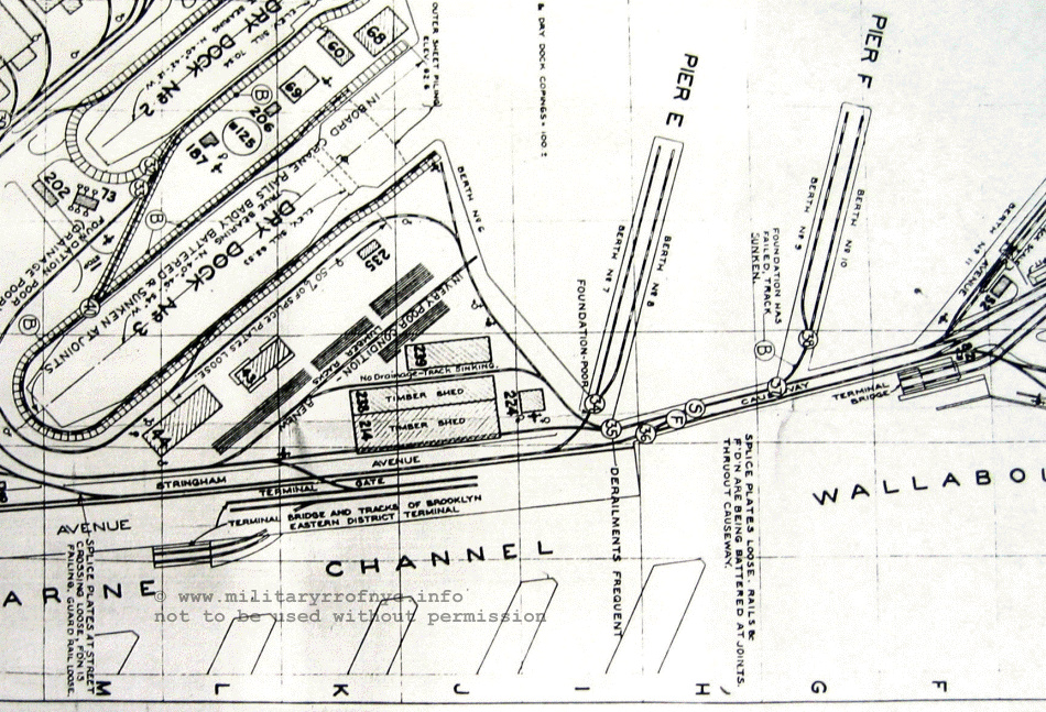
Brooklyn Navy Yard - 1940
National Archives, New
York City branch
courtesy of T. Flagg
added
26 July
2016
.
.
It is pertinent to keep in mind, that this track arrangement only existed from 1936 through 1941 at which time the Navy Yard underwent expansion and modernization, and the new Overhead Suspended Contained Apron (French Type) transfer bridge was constructed.
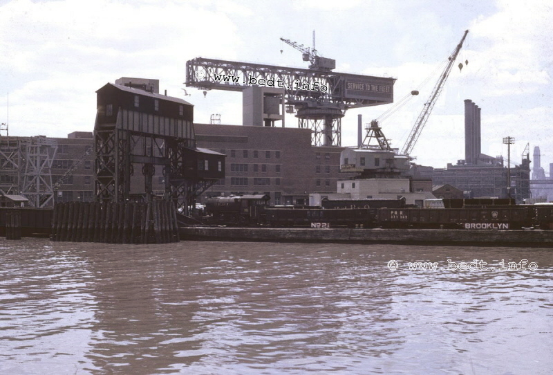
BEDT 16 on carfloat 21 at Brooklyn Navy Yard floatbridge - June 24, 1963
unknown photographer
authors collection
.
.
According to the Coverdale & Colpitts Report, the Brooklyn Eastern District Terminal served the Brooklyn Navy Yard under exclusive contract, renewable on a yearly basis. It is understood that this contract was awarded to the BEDT as the result of that prior to World War II, the BEDT had maintained a railyard on Wallabout Creek adjacent to the Navy Yard. Ascertained through other documents, that just prior to the onset of World War II, the Government annexed all adjoining properties to expand the Navy Yard, with the BEDT Wallabout property included. In lieu of "losing" their Wallabout property to this annex, the US Government awarded the carfloat service contract to BEDT.
This carfloat service contract consists of floating cars to the Navy Yard from the Kent Avenue Yard, and never direct from any other carfloating facility or terminal. Freight cars destined for the Brooklyn Navy Yard would be received from the various Class 1 Railroads at their respective New Jersey terminals. These cars would all be carfloated to the Kent Avenue yard, "pulled" from the various carfloats and set aside in a portion of the BEDT railyard. On a scheduled day, the BEDT would load a carfloat with all the freight cars and one locomotive, and a tug would transport this carfloat to the Brooklyn Navy Yard.
Upon arrival at the Brooklyn Navy Yard, BEDT locomotives and personnel would unload or "pull" the cars off the BEDT carfloats to a railyard off the float bridge lead, and Navy personnel would take over and switch the cars to appropriate destinations within the Brooklyn Navy Yard property with Brooklyn Navy Yard locomotives. Outgoing freight cars would be reloaded on the carfloat with the BEDT locomotive, and the carfloat would return to Kent Avenue.
Starting in or around 1960, the Navy Yard diesels began to be sold off or transferred to the USN Storage / Supply Depot in Bayonne, NJ. It is believed that it was at this time that the Brooklyn Eastern District Terminal assumed all rail operations: offloading the carfloats and switching cars within the Navy Yard properties. This arrangement continued even after the Navy Yard properties were released from government control to civilian ownership in 1966.
When the New York Economic Development Corp took over the Brooklyn Navy Yard property in 1967, new civilian customers took up residence within the Navy Yard and rail traffic actually increased somewhat, with BEDT providing rail services. But, this boom would not last long and evaporate when New York City entered its financial crisis in the early 1970's.
For a detailed listing of the freight / cargo arriving at the Brooklyn Navy Yard, please refer to the Brooklyn Navy Yard section of the Customers / Commodities chapter of this website.
Upon the cessation of BEDT operations in 1983, it's successor; the NY Cross Harbor RR, would operate in the Brooklyn Navy Yard. For more information regarding NY Cross Harbor RR operations at the Brooklyn Navy Yard, please visit the companion page: New York Cross Harbor RR
.
.
.
The BEDT also operated, for a limited time; what is understood to be a non-rail interfaced truck terminal and pier / wharf station, known as the "Queensboro Terminal". No float bridge existed at this location, and this location was a wharf station only.
This was located in Long Island City at the East River and 14th Street (now 44th Drive). This terminal is also commonly recognized at the 13th Street Terminal.
Dates of service of this location are from 1914 through about 1930.
Located in July 2026, and housed in the New York Municipal Archives, is a series of waterfront survey maps drawn for the City of New York Department of Dock and Ferries. Queens Plate 25 contains the property that would be the Queensboro Terminal. While in the maps the 'L' shaped pier house and an adjacent basin are seen, there is no mention of the Brooklyn Eastern District Terminal. But it is known from experience and other maps of this series, they were not always updated or corrected religiously - this is to be expected considering the vast amount of waterfront property the City of New York administered to.
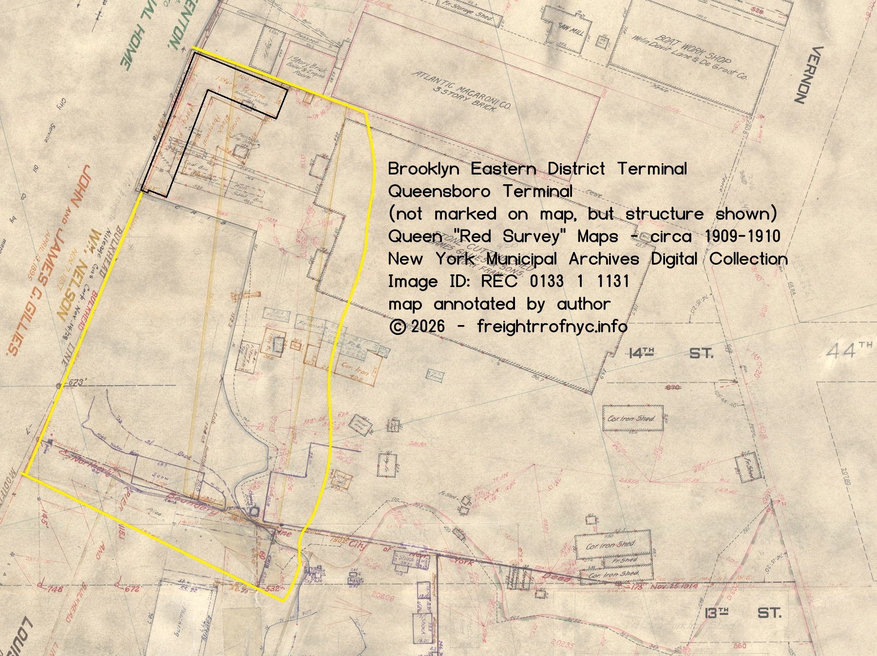
Tom Hendrickson located a New York Times article dated 1914, announcing the opening of the Queensboro Terminal, which can be viewed here:
Queensboro Terminal - New York Times - May 24, 1914
If you reference the New York Times article above,
you can read
how there was every intention of a railyard to be built at this
location
and according to that New York Times article, there were supposed to be
multiple
piers constructed at this site as well.
The Belcher Hyde map of 1918 (below) does not show any trackage, but does show a significant amount of vacant land adjacent to the terminal:
.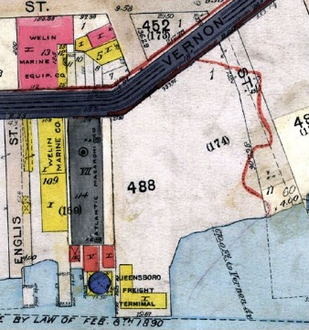
E. Belcher Hyde Map, 1918
(north is right)
In a conversation with Tom Flagg, he informed me of a 1920 "Joint Report" where it is stated that the QBT was reduced to a pier station only with no transfer bridge.
According to the 1927 ICC Valuation Report, there was indeed trackage at this location with it's cumulative length included in the 7.890 miles leased from Havemeyer's & Elder, so perhaps the float bridge and railyard was built and did briefly exist at this location once again. You can reference the Valuation Report for yourself here: 1927 BEDT / ICC Valuation Report.
Below is an advertisement for the Queensboro Terminal. Seen in the bottom left corner of the image can be seen the letters ROOKL with the left half of R and right half of L cut off, and judging from the shed like structure on the top, this is a Brooklyn Eastern District Terminal station carfloat located behind the building.
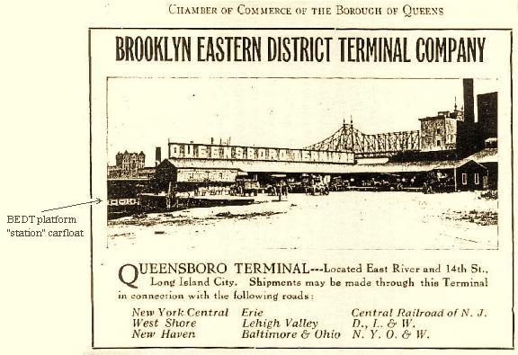 .
.
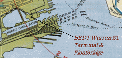
In the previously mentioned 1927 ICC Valuation Report, a BEDT yard located at Warren Street in Jersey City, NJ; was mentioned.
I am sorry to say, I had not known about it until reading this report, so it was rather a shock to learn of it. The property at this location was both owned by Havemeyer's & Elder, and consisted of property that was exclusively leased to the BEDT. This 1927 Valuation Report shows 1.129 miles of track at this location, and mentions this location having a float bridge. It states:
"The New Jersey properties are on similar land on the north shore of Tidewater Basin in the southern section of Jersey City."
..
Tom
Hendrickson; the son of Francis,
a BEDT conductor; was kind enough to send the following item that he
located.
It is a residence/business prospectus/advertisement dated 1911 for
attracting
residents and industry to Jersey City. In it, it goes on to state:
"3. Its latest dock and float bridge, at the foot of Warren Street...." [and on the next panel, states] "this new enterprise, engineered by the New York and New Jersey Realty Co. and Brooklyn Eastern District Terminal."
It
should be noted, that Henry
O. Havemeyer (the nephew) was President, Secretary &
Director of
the New Jersey & New York Realty & Improvement Company
(as listed
in the Directory of Directors, 1914). I have uploaded the brochure as
scanned
and highlighted the appropriate text, and it was tweaked thanks to Paul
Strubeck
to make the file size more manageable. Also scanned is the map on the
reverse
side, but does not show any marker for the BEDT. I placed a pointer
showing
the relative location for reference. You can view both the prospectus
and
the map on the reverse side of the prospectus at:
After reading
that prospectus, not only
do we have confirmation that the BEDT had presence in Jersey City and
confirms
the Warren Street float bridge but it gives us a rather accurate date
as
to the beginning of BEDT operations at Warren Street,
being circa
1910-1911.
Shortly following this discovery, Paul also located two pictures that he found on the web in which you can see a curved freight platform and a single wood boxcar. These pictures are from the New Jersey Department of State Archives and the top photograph is titled: "From the canal, looking West at Jersey City". The bottom photo is titled "The Basin of 1867 and the Inner Basin and Morris Canal, at Jersey City [looking west]". The map insert (to left of picture) is from the prospectus map and I have turned the image to look west.
Note how the curve, canal and view line up between the prospectus map and the photos. Furthermore, the bridge crossing the canal in mid-foreground has tracks running in street to right of it, and this would correspond very well with the top most track which is the Pennsylvania RR Hudson Street Branch (running south/north) in map inset.
I have to admit, I was somewhat hesitant to consider these pictures of the BEDT Warren Street Terminal but made the statement here, that it was. I was in error as Tom Hendrickson pointed out these pictures are from a 1903 report to investigate the abandonment of the Morris Canal, which predates the 1911 prospectus mentioned above.
Tom hypothesized that even though we knew
there was a BEDT Warren Street Terminal, but there may have also been a
Lehigh
Valley Warren Street Terminal as well (and not as a predecessor or
successor
to the BEDT terminal, and was a completely separate facility) and that
these
photographs are most likely of the Lehigh Valley Terminal.
.
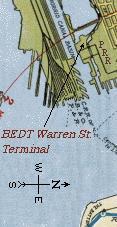 |
|
|
. |
|
|
|
|
A few days later (after finding the above pictures), I get a late night phone call from Paul, who upon browsing a book, discovers a Port Authority map (shown below) showing a Warren Street Terminal under Lehigh Valley ownership. The inner basin, and canal are filled in and unfortunately the map is not dated, but does show the track lead and the PRR trackage east of it, which aligns itself nicely with the photos above. Ok, so now we know the platform in the pictures is Lehigh Valley, but where was the BEDT Terminal in relation to this platform?
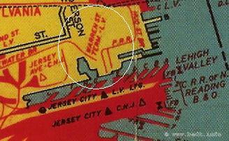
(north
is up)
Well naturally, I'm back to square
one and getting frustrated! Paul suggests to me, why not just email Tom
Flagg?
He's the best there is when is comes to Rail - Marine Terminals, not to
mention
it being stated on Sam Berliner's site that Tom Flagg reported seeing a
track
map of the Warren Street Terminal. So, I compose and send an email to
Mr.
Flagg, who was prompt, enthusiastic and quite
helpful in his
reply:
"Your BEDT website is certainly a mine of information about the subject! I will be glad to help with a map of that terminal. I just checked through my already-digitized stuff and was surprised to find I don't have it there. But this evening I will check into my collection for you.
I have some information from a report by Benjamin Squires "New York Harbor Employees", in the Monthly Labor Review, July 1918, (at South St. Seaport Museum Library), p. 3:
"The Brooklyn Eastern District Terminal has a small terminal at the foot of Warren Street, Jersey City, adjacent to a refinery of the American Sugar Refining Co., but that terminal is not connected with any of the trunk lines and is not generally used by Jersey City shippers.
The Refinery burned down in 1924, which may have been a factor in the terminal's abandonment." Tom (Flagg)
.
.
Two days later,
I receive the map and
caption below from Tom :
"This map is a portion of Pl. 1 from the Hopkins Hudson County Atlas, of 1919, showing the Warren St. Terminal of BEDT. "Transfer Bridge" is the technical term for what what is popularly called a "Float Bridge". As is typical of Insurance / Real Estate Atlases, do not expect complete accuracy in the track plan.
It is mostly correct schematically (i.e., the number of tracks and switches and their relation to each other), but not in exact location of the track. Also, on the original map the lead track from the float bridge (the horizontal track at top) connected to PRR's track in Warren St., and not to its own trackage! A pencil stroke has been added here to correct this mistake, as it is known from other sources that the BEDT trackage formed a complete loop at this terminal.
It did not connect with the track in the center of Warren St., which was part of the Hudson City Branch of the Pennsylvania RR that transversed the streets of Jersey City, worked at this time by horses! A major fire in 1924 destroyed most of the neighboring sugar refinery (which was a branch of the American Sugar Refining Co.) and probably did damage to the BEDT's property.
The terminal had not been used much by local industry, and the BEDT probably figured it wasn't worth restoring the terminal at that point. Interestingly, even though the BEDT was directly across the driveway from the Lehigh Valley Warren St Terminal platform, it appears from the map that the BEDT did not share the platform."
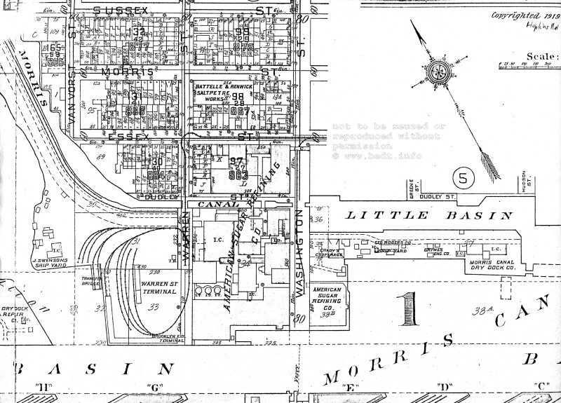
G. M. Hopkins Map, 1919
There you have it BEDT fans. Thanks to Tom, we now
know what
the BEDT Warren Street Terminal track layout looked like and where is
was
situated in relation to the photographs above. As Tom knows a great a
deal
more about this Warren Street Terminal than I have learned so far, I'm
going
to defer to his email to give the history of the Terminal:
|
.
Anyhow,
we can see from the map,
the BEDT Warren St Terminal had it's own platform in the center of the
innermost
"loop" track and did indeed have a single float bridge west of the
platform.
This leaves one vital unanswered question: did the PRR (and
not BEDT
as expected) service the American Sugar Refining building at the foot
of
Washington St on the canal?
As per Tom Flagg, the BEDT did not interchange with PRR Hudson Street Branch on Warren Street (and naturally I would not have expected it to, as from precedent, the BEDT never had physical track connections to either PRR at North 4 Street or Long Island Rail Road at Pidgeon Street, even though the tracks for those railroads would be literally with in a few feet from BEDT trackage).
But to get to the American Sugar building on Washington Street you must follow the PRR trackage on Warren Street (left track down center of street) and travel two blocks north and then curve eastward onto Essex Street and proceed one block to Washington Street, where reversing direction and transversing through the turnout, which thereby takes you south onto the Washington Street spur and back to the foot of Morris Canal Basin next to the American Sugar building.
If BEDT did not use the PRR Trackage, then PRR would have had to pick up drop off / at this facility, shove the cars onto Warren Street and somehow transload the items onto cars on BEDT tracks. Were freight cars parked side by side on Warren Street for this transfer / transloading of freight?
Then several months later, Paul Strubeck sends me various .pdf files from documents and books pertaining to the Brooklyn Eastern District Terminal and other Port of New York Terminals he located during "Google" searches. One of these books is titled:
"Ports of the United States, Department of Commerce
-
Bureau of Foreign & Domestic Commerce;
Miscellaneous Series - No. 33;
Report on Terminal Facilities, Commerce, Port Charges, and
Administration
as Sixty-Eight Selected Ports",
by Grosvenor M. Jones, 1916.
On page 113 of this book, in the Brooklyn Eastern District Terminal chapter it states:
"The Jersey City Terminal of this company is located at the foot of Warren Street on the Tidewater Basin of the Morris & Essex Canal. This terminal has direct connection with the various railroads having terminals on the New Jersey shore of the New York Harbor, and has a freight yard with a capacity of 100 cars, car-float bridges, and warehouses for the storage of freight."
If some of you
have failed to recognize
any significance in that passage, please take particular note of the
second
sentence: "This
terminal has direct
connection..."
This new information unfortunately contradicts the previous information as supplied by Tom Flagg, listed above and of which I regard as gospel. I immediately emailed Tom and both Tom and I agree that further proof is required to substantiate this claim of direct connection of BEDT to other railroads, but according to all other documents, there was no interchange. Also as a result of this new information, I found it pertinent to now show the unaltered version of the Warren Street Terminal map for comparison:
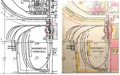
Left
map courtesy of
Tom Flagg.
Right map courtesy of Ralph Heiss.
My thanks to both!
The red circled area in the left map shows the penciled in "crossover" (diamond) over the left and connecting to the right track (and partially obliterating the bottom left leg of the letter "R").
The
red circled area in the right map shows no such revision with no
turnout on the right track and no crossover on the left (and this being
the original map).
Both maps appear to be identical to each other in every other aspect,
save for black and white and color formats.
If one studies the track layouts, one can realize that with the track layout in the right or original map, a locomotive cannot "run around" a car or cut of cars, and therefore once a string of cars has been pulled from the carfloat, the locomotive is "trapped" at that end of the train.
However, with the revised map, that crossover now allows a locomotive to pull a string of cars off a car float, uncouple from the cars on Warren Street, and continue to run around the loop and ending up in on the opposite side of the cut of cars, allowing the locomotive to pull a car or cut of cars in the other direction, as well as from either direction.
With this latest thorn in our side, Tom sent an actual advertisement released by the Brooklyn Eastern District Terminal, with a copy of the track arrangement. While not clear enough in this image, the track map appears to be taken directly from a blueprint and dimensions and track numbers are listed. In any event, this map clearly shows the cross over in the middle of Warren Street.
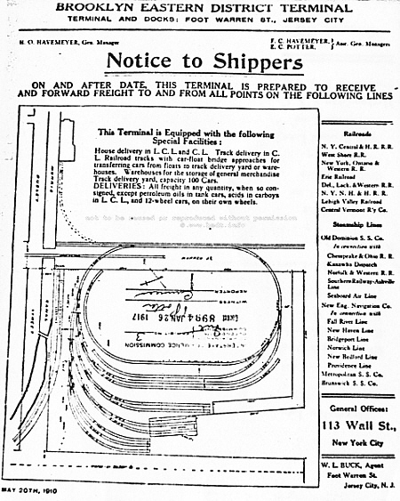
North
is left -
advertisement courtesy of Tom
Flagg.
So, if my opinion matters for anything, I now have to concur with Tom on this "interchange / direct connection" question, in that the Brooklyn Eastern District Terminal did NOT directly interchange with the Pennsylvania Railroad at this location. I also took note of something else on the advertisement. In the column on the right, it fails to mention the Pennsylvania Railroad as a point to receive or ship freight from this Warren Street Terminal, which is odd as Pennsylvania is right on the street!
A United States Geological Survey
aerial photo of the area taken in 1931 shows the float bridge
and yard
to have been removed, and it appears the neighboring shipyard has taken
over
the property as several floating drydocks can be seen at the
bulkhead.
Presently, this same area has witnessed a conversion to upscale
residential
condominums, and a marina is now located at the bulkhead where the
float
bridge was formerly located.
.
.
.
Greenville Yard could be considered the largest yard operated by BEDT (after 1976). While not technically Brooklyn Eastern District Terminal property (it was leased from Conrail after 1976 to continue carfloating operations in New York Harbor), it was a vital part of BEDT operations after 1976.
Greenville Yard is located in Jersey City, NJ; and was originally built in 1904 by the Pennsylvania Railroad upon swamp land. Greenville in its heyday was a monstrous yard, featuring a series of float bridges, a hump yard, car repair shops, and even a yard to stage steel structural components for the then booming Manhattan Island "skyscraper" construction period. The original float bridges were of wood construction and of Howe Truss design, and the gantries were of wood construction as well.
The Pennsylvania Railroad upgraded the float bridges and gantries following a massive fire in 1931, with six all new steel plate girder bridges, numbered from north to south: 9 1/2, 10, 11, 12, 13 and 14. The reason for 9 1/2 being numbered in the "half", was to avoid confusion with a #9 float bridge that was already in service for the Pennsylvania Railroad in their Harsimus Cove railyard which was 2 miles north of Greenville. These new float bridges used a main bridge as well as a separate apron. These "double apron" types are of the "Bensel Patent", which help relieve stress put on the toggle bars during loading/unloading, have a pair of parallel gantries or machinery houses.
As previously stated, BEDT would operate the Greenville Yards following the 1976 formation of Conrail. The reason for this is Conrail did not want any sort of involvement in rail-marine operations, and thus the yard and floating rights were leased to Brooklyn Eastern District Terminal. Brooklyn Eastern District Terminal would also lease several different Conrail locomotives over the years. (See Diesel Locomotive overview for more information).
After the 1979 merger of New York Dock & Brooklyn Eastern District Terminal, the yard became under the operative control of New York Dock, who also handled marine operations for the Baltimore & Ohio RR at that time. When New York Dock & Brooklyn Eastern District Terminal both ceased operations during the first week of August 1983, the New York Cross Harbor RR was formed two weeks later, and the Greenville lease carried on to them. This lease has subsequently been transferred to their successor: New York New Jersey Rail.
Currently, Greenville is a shadow of its former self, with less than one quarter of the original trackage remaining in place but at least it survives and continues to be used in the matter in which it was constructed for. However, all the original Pennsylvania Railroads transfer bridges are now gone. Bridges 13 & 14 collapsed in 1992 due to underscoring and they were subsequently torn down. Bridges 9 1/2, 10, 11 and 12 survived into 2012, but only #11 was in service ,with an anticipated rebuild of #12 if traffic warranted. Unfortunately, all were irreparably damaged due to Hurricane Sandy in October 2012 and subsequently demolished. NYNJ Rail would relocate the Bush 2 pontoon type float bridge to Greenville to keep carfloating operations alive between Greenville and 65th Street Yard in Brooklyn.
For more information on this location, please visit the companion pages on this website at:
The Development of Carfloat Transfer Bridges of New York Harbor
.
Float Bridges /
Transfer Bridges of the B.E.D.T.
.
..
|
|
||||||||||||
.
There were
three distinct types of float bridges inherent to Brooklyn Eastern
District
Terminal operations and which are shown side by side for comparison,
and
discussed in detail below. Lengths and cosmetic appearance of the float
bridges
varied by builder and need.
.
|
float bridge location |
neighborhood | bridge span type | style | status |
| Greenville
Yard Brooklyn Navy Yard North 3 Street North 5 Street North 6 Street North 9 Street Pidgeon Street Warren Street |
Greenville,
NJ Wallabout Basin, Brooklyn Williamsburg, Brooklyn Williamsburg, Brooklyn Williamsburg, Brooklyn Williamsburg, Brooklyn Long Island City, Queens Jersey City, NJ |
pony
plate girders (6) pony plate girder pony truss pony plate girder pony truss pony truss pony truss unknown |
Overhead Suspended
Separate Apron -
"Bensel" Type 1 Overhead Suspended Contained Apron - "French" Type 2 Pontoon Pontoon Pontoon Pontoon 3 Pontoon unknown |
demolished 11/2012 original gantry remains, North 9th Street float bridge replaced original span, now abandoned & sunk removed ca. 1960 removed & scrapped 11/2008 removed & scrapped unknown date relocated to Brooklyn Navy yard abandoned in place 1978; removed / presumably scrapped 8/2016 removed unknown date ca. 1924 |
.
Footnotes:
1
= facility leased from Conrail, 1976
2
=
Converted to pontoon
style, see below
3
=
relocated to Brooklyn
Navy Yard ca. August 1983
Float /
Transfer Bridge
Types:
.
|
|
The six float
bridges that were located
in Greenville, NJ and that were used by the Brooklyn Eastern District
Terminal,
did not actually float on the water but are suspended by flat steel
"eye
bars" and cables. Each main float bridge (not the
apron) was suspended
by eight 2 1/2 inch diameter multiple stand
steel cables,
four of which are attached to the center girder and two each to the
outside
girders by eyelets. These were in turn are attached to four 53,000 lb
counterweights through a series of sheaves. These counterweights
carried
90% of the float bridge's dead weight. These transfer bridges were
raised
and lowered through electrical motors and worm screws.
The former bridges at Greenville were manufactured by two different companies; those being American Bridge Co, and McClintic Marsh Co. For detailed build dates, specifications, diagrams and history of the Greenville bridges, I recommend you visit this website's companion on transfer bridges:
.
.
.
Contained Apron or "French"
Type
The transfer
bridge located at the Brooklyn
Navy Yard after 1941 was installed by the US Navy, but used by Brooklyn
Eastern
District Terminal. It was originally of the French Patent type:
overhead
suspended contained apron. Being named a "French Type" for having been
designed
by James B. French in 1911. The motors for adjusting
the height of the
float bridge decks were also powered by electricity, but the French
type
float bridge consisted of a single overhead gantry covering two
parallel but independently suspended and operated bridge
decks. The
two bridge decks would be connected to the bulkhead on one end, with
the
carfloat being moored to the other end. The Contained / French type had
two
separate hoisting mechanisms in the gantry, one for each deck, which
allowed
the two bridge decks to be adjusted independently.
The other significant difference between Contained Apron (French) and Separate Apron (Bensel) types, is that the French utilized self contained aprons (which were not counterbalanced or friction braked) and were built and recessed into the outer (water) end of the float bridge deck, and were permitted to rise or fall with the twist of the carfloat (as it listed when cars were placed or removed onboard the carfloat). However innovative this design may have been, some railroads such as the Pennsylvania preferred the separate apron type.
About 1983, the Brooklyn Navy Yard float bridge was converted from the French type to a pontoon type, but the overhead gantry was left standing even though it would no longer be attached to the float bridge. It remains standing to this day. However, there is at this time, some "cloudiness" regarding the replacement float bridge(s):
The current pony truss / pontoon style float bridge at the Navy Yard was brought there in 1983, and is the float bridge from North 9th Street. However, there is a second float bridge, a pony plate girder; laying in the water in a mostly sunken state (not connected to anything) and to the east of the float bridge gantry.
From research by Paul Strubeck and Benjamin W. Schaeffer, it appears this derelict float bridge was originally from Delaware, Lackawanna & Western Hoboken Terminal (and not Central Railroad of New Jersey as originally stated here). This float bridge was brought there first to replace the original French Type span.
It is seen in an 1980 aerial photo sitting near the gantry, with a pontoon under its land side (making it totally buoyant, and movable by towing). For some as yet undetermined reason, this pony plate girder was defective or incompatible in some way, and was not able to to be installed at this location.
After BEDT closed in 1983, New York Cross Harbor then replaced that pony plate girder with the second replacement float bridge, this being the pony truss in place now. This float bridge having come from the BEDT North 9th Street location (according to Fred Breimann, retired Bush Terminal and New York Dock locomotive engineer). We do not know what became of the original French bridge span, but must presume it was scrapped.
The reason we know for fact that the pontoon pony truss float bridge arrived after August 1983, is that in reviewing extensive photos on this website, and those taken by John McCluskey at the Brooklyn Navy Yard in 2006, I have matched the float bridges right down to location of dents and placement of electrical conduit. As the North 9th Street float bridge was used to load the locomotives onto a carfloat at the end of operations at Kent Avenue in August 1983, this float bridge would have needed to have been moved after this date.
For detailed build dates, specifications, diagrams and history of the Brooklyn Navy Yard transfer bridge, I recommend you visit this website's companion on transfer bridges:
The Development of Carfloat Transfer Bridges of New York Harbor
.
.
.
Pontoon
Type:
.
.
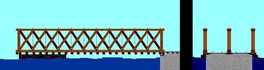 |
Howe Truss Deck:
wood timber |
| . . |
|
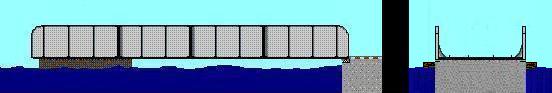 |
Pony Plate Girder Deck:
wood timber on steel girders |
| . . |
|
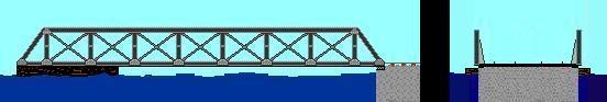 |
Pony Truss Deck:
wood timbers on steel
girders joints reinforced with riveted plates |
Please note: for clarity, I have omitted wood pilings, winch mechanisms, carfloat jack, etc.
The Brooklyn
Eastern District Terminal
float bridges located along Kent Avenue, at Pidgeon Street and at
Warren
Street in New Jersey were all of Pontoon type, meaning they were
supported
by a huge steel tank affixed to the underside of the bridge span for
flotation,
and were equipped with hand winches only for the hawser lines to keep
the
carfloat drawn tight against the float bridge. These float bridges were
adjusted
for height by slowly advancing the locomotive to bear it's weight down
on
the bridge, thereby pushing it down into the water,
eventually to match
the height of the float bridge to the deck of the carfloat.
If for some reason, the carfloat was riding high in the water (i.e. empty or light load, or a leaky pontoon causing the float bridge to sit low in the water), there was a manually operated hydraulic jack that hung over the water end of the float bridge and that a piston could be pumped down. This in turn contacted and pushed down on the carfloat deck, thereby raising the float bridge. As the carfloat was larger and had more buoyancy than that of the float bridge, which was the lighter weight of the two objects, it would be the float bridge that raised up and not the carfloat that would be pushed down into the water.
Some designs of pontoon supported float bridges has a small wood or steel gantry over the water end of the float bridge. This gantry contained sheaves and cables connected to hand winches for raising the float bridge in case of a mismatched float bridge / carfloat height or for pontoone maintenance, but never for carrying the weight of cars or locomotive. As far as it is known, BEDT did not employ these overhead gantries on any of their pontoon type float bridges.
The wooden Howe Truss style is now shown, because it is believed that the original float bridges along the Williamsburg waterfront were originally of this construction, (and possibly the Warren Street Terminal as well). All the Howe Truss style float bridges were of creosoted wood construction, with the exception of the pontoon tank, hawser winch mechanism and the threaded rods and brace plates.
If there were Howe Truss style float bridges located at Palmer's Dock / Brooklyn Eastern District Terminal, they were all eventually replaced with either pony truss or pony plate girder throughout the years, so that none remained by 1914, the earliest dated photo we have seen to date. The actual date remains unknown when last Howe Truss was removed from Brooklyn Eastern District Terminal service. By viewing the 1924 aerial photo, the only remaining Howe Truss in Williamsburg by that year was the Pennsylvania Railroad's North 4th Street float bridge.
For detailed specifications, diagrams and history of the Brooklyn Eastern District Terminals; float bridges, I recommend you visit this websites companion on transfer bridges:
The Development of Carfloat Transfer Bridges of New York Harbor
..
Surviving
Float Bridges of the B.E.D.T
.
As of November 2008, Paul Strubeck informs me that the Brooklyn Eastern District Terminal North 5th Street Float Bridge is no more. I was fortunate to have photographed it just a few months prior in July 2008, from on board the Lehigh Valley tugboat "Cornell" on a tour of New York Rail-Marine facilities.
So, we were only able to enjoy the sight of one surviving float bridge owned by the BEDT: the Pidgeon Street float bridge (pony truss) in Long Island City, Queens.
The Pidgeon Street float bridge is derelict, (abandoned in place) and is partially are sunk, with the timber decking having been removed. The bridge builders plates has been removed; and so to the lucky owner(s) of both the Pidgeon Street and North 5th Street float bridge builders plates, please feel free to forward pictures of either / both bridge builders plates!
Here is one of the last photos of the North 5th Street float bridge before its removal:
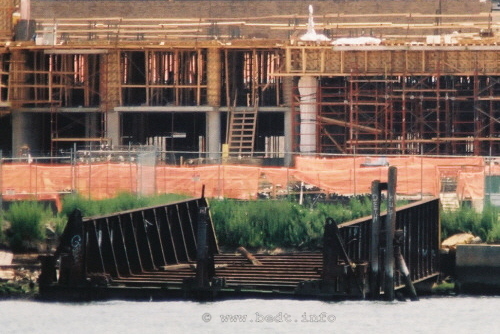
North 5th Street float bridge (Williamsburg, Brooklyn) -
July
12, 2008
P. M. Goldstein photo
.
.
The following
are photos of the "second"
Pidgeon Street float bridge. Please take note that this float bridge
was
installed at this location sometime after 1958, as a photo of the float
bridge
in place at this location in 1958 is of a different construction
design.
Further information and the image of this original float bridge can be
found
in the Pidgeon Street chapter:
As of August 2016, it is my sad duty to report once again via Paul Strubeck, that the Pidgeon Street float bridge is no longer on the shoreline. It was previously published that it was to be saved and made part of a park at that location (much in the manner of the Baltimore & Ohio Railroads West 26th float bridge in Manhattan).
While it may have been removed for rehabilitation for the proposed park, it is more likely that it has been scrapped due to the rampant gentrification of the Brooklyn & Queens waterfront along the East River.
|
|
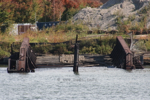 |
Pidgeon Street (Long Island City, Queens) float bridge (second) - July
2008
both photos (bottom): P. F. Strubeck
.
.
This means, only one BEDT float bridge remains in existence: the relocated North 9th Street at Brooklyn Navy Yard.
John McCluskey took extensive images of this former North 9th Street float bridge, now located at Brooklyn Navy Yard and his album may be viewed here:
| Structure 713 - Brooklyn Navy Yard; by John McCluskey |
.
..
Unloading or "Drilling"
A
Carfloat ..
.
The procedure for unloading a carfloat can be viewed below. Please note, this procedure would apply in 99% of the time. In certain unusual cases, the procedure was modified to accomodate an extra heavy or wide load or special circumstance. While the diagram below shows a pontoon float bridge, the procedure was the same at overhead suspended transfer bridges.
|
|
Numbers in description correspond to the numbers in following illustration:
Locomotive is inched
forward onto float bridge to bring it into same
height as carfloat. Carfloat is secured to float bridge using method
and appliances outlined in above
chapter. Locomotive then couples up to cut of cars
on starboard side track.
Locomotive pulls cut of cars on starboard side track half way off the carfloat and onto the float bridge lead; leaving part of the cut of cars still on float bridge and carfloat;
The locomotive uncouples from starboard side cut of cars, and locomotive continues past float bridge lead turnout. Turnout is thrown and aligned for port side track.
Locomotive heads forward onto port side carfloat track, and couples up to cut of cars on port side track.
Locomotive reverses
direction, and pulls entire cut of cars off of port
side track of carfloat and past float bridge lead turnout; and float
bridge lead turnout is thrown and aligned
for starboard side track.
Locomotive proceeds forward pushing port side cut of cars and couples up to starboard side cut of cars.
Locomotive reverses
direction and pulls combined port and starboard
side cuts of cars off carfloat to clear the turnout on float bridge for
carfloat center track, and points of
center track turnout are thrown and
aligned for center track;
Locomotive pushes combined port and starboard of cars onto carfloat, coupling up to string of cars on the center track of carfloat.
Locomotive reverses
direction, and pulls entire cut of
cars (combined port starboard and center track cuts of
cars) into the yard.
Carfloat is now unloaded. To load carfloat, reverse procedure.

.
Would
you like to see this operation in
real time? Visit videos on YouTube
at:
.
..
.
The Brooklyn Eastern District Terminal employed a rather large staff. In the Public Service Commission report of 1915, it recorded a staff of 458, inclusive of it's executive administration. In this publication is a breakdown of departments and employee staffing, and I have included an image of that categorization breakdown:
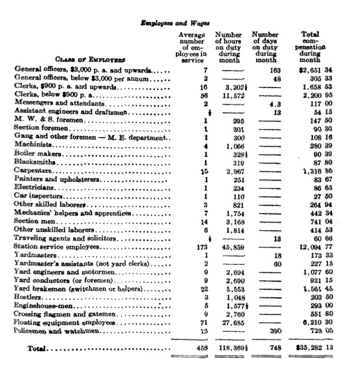
Take note of the last line: Policemen and watchmen: 13; what I consider to be a sizable force in 1915. One must remember, the Brooklyn Eastern District Terminal not only employed those people necessary for railroad operations; but also for their nautical operations, including the piloting and maintenance of the Tugboat and Carfloat fleet. But oddly, what I do not see on this list is captains, mates and deckhands; unless they are cumulatively listed under "Floating equipment employees".
In 1959, it would go on to report in a Railroad Magazine feature article a significantly lower amount of 252 employees, inclusive of it's executive administration.
I have also found that compiling this personnel information has been the most difficult aspect of my assembling a detailed history of BEDT operations. Even more difficult are finding the names of the Palmer's Dock and East River Terminal employees and administration.
I have realized that one person was omitted from the list below, that being Lowell Palmer. One has to remember him as a "founding father", as well as a partner with Havemeyer's & Elder in the creation of the East River Terminal. We also know he would come supervise the daily operations of East River Terminal, but his exact title is unknown. So without undue insult to his importance in the history of Palmer's Dock, East River Terminal / Brooklyn Eastern District Terminal, he stands above the rest, until his title is learned.
To date, only a few BEDT employees (J.
Roborecky, F. Laczynski and J. Rodecker) and three relations (T.
Hendrickson,
M. Brusich, Lorraine Wymbs nee Kubicki) of BEDT employees (F.
Hendrickson,
N. Brusich, B. Kubicki respectively) have contacted me. Hopefully that
number
will grow as this website gains momentum, and I certainly invite all
BEDT
alumni and descendants to contact me. I sincerely hope more employees
and
the descendants thereof would contact me as I would like to assemble a
moderately
complete list of BEDT veterans. I have heard third hand, that there is
only
one surviving steam locomotive engineer, and does not wish to be
bothered.
So until more of these former employees and relations thereof contact
me;
I only have the following information to offer which has been complied
from
those people that have contacted me and from literary sources.
In some cases, you will notice a particular person
is listed
in two separate titles / offices during the same time frame. As this
data
is compiled from different documents, it is unclear whether
that person
genuinely held two offices during the same time frame, or that person
changed
positions / titles.
.
|
Are
you a BEDT "alumni" or a
descendant of one? |
E.R.T / B.E.D.T. Employees
Administration
| Henry
O. Havemeyer, (uncle) Henry O. Havemeyer, Sr. (nephew) Marion M. McClellend Nicholas G. Cutter |
President President & General Manager |
1875 - 1907 < 1917 > 1961 > < 1965 - 1972 > |
| Henry O. Havemeyer, Jr. (son of nephew) | Assistant to President | 1926 > |
| Henry O. Havemeyer, Sr. (nephew) | Executive Vice-President & Treasurer | < 1952 - 1965? |
| Christine A. Pasquariello | attorney / senior vice president (BEDT/NYD) | < 1981 - 1983 > |
| Frank F. Dayton | Vice President of Operations | < 1972 > |
| Horace
Havemeyer Edward C. Potter, Jr. C. G. Phillips H. J. Shepard Marion M. McClelland Nicholas G. Cutter J. D. Mead Al Malone Van Grace |
Vice-President
(ERT) |
<
1917 > < 1912 - 1920 > < 1921 > 1926 > < 1952 > < 1952 -1965 > < 1963 - 1969 > < 1979 > < 1981 > |
| Frederick
C. Havemeyer M. Marincell |
Treasurer Treasurer (also manager of revenue accounts, personnel & purchasing & stores) |
< 1917
> < 1969 - 1972 > |
| Edward
C. Potter Jr. Charles H. Jackson |
Assistant
Treasurers (ERT) |
<
1917 > < 1917 > |
| Charles R. Heike | Secretary & Treasurer | < 1907 > |
| J.
H. McCafferty L. H. Shereff |
Secretary
(also Sec'y of Eat River Terminal RR) |
<
1926 - 1942 > < 1969 - 1972 > |
| Rae Sokoloff | Assistant Secretary | < 1972 > |
| Harry
A. Coop J. Lang |
Auditor |
< 1926
> < 1972 > |
| T. F. Smith | Auditor of Freight Accounts | < 1926 > |
| J. D. Mead | Terminal Engineer | < 1952 |
| J.
O. Havemeyer, Jr. Henry O. Havemeyer C. G. Phillips H. H. Shepard Marion M. McClelland |
General
Manager |
<
1910 > < 1920 > < 1921 > < 1927 > 1938 - 1961 |
| Edward
C. Potter Jr. John T. Moore |
Assistant General Manager | 1909
- 1912 < 1968 > |
| Thomas
Kilpatrick Walter DeSheers |
General
Superintendent (ERT) General Superintendent (BEDT/NYD) |
<
1917 > < 1979 > |
| John Moore | Terminal Superintendent | < 1977 > |
| W. J. O'Keefe | Superintendent and General Agent | < 1969 - 1972 > |
| Riley
L. Williams (also
shown as
traffic manager) Frank F. Dayton (also shown as VP of op's) |
Superintendent
of Operations |
< 1926
- 1942 < 1968 - 1972 > |
| Charles Ferris | Mechanical Superintendent | < 1917 > |
| Charles Ferris Thomas Kilpatrick P. J. Martin |
Superintendent of
Equip. & Structures |
<
1910 - 1917 > < 1916 - 1927? > < 1952 > |
| R. J. King | Manager of Data Processing | < 1972 > |
| ?. Dettman | Chief Dispatcher (Tugs) | < 1942 > |
| Anthony A. Lembo | Tug Dispatcher & Terminal Sup't | < 1968 > |
| J. Todd | Master Mechanic | < 1952 > |
| Riley
L. Williams |
Master
Mechanic Superintendent of Maintenance |
<
1963 - 1969 > < 1972 > |
| Raymond Aufiero | Mechanic | < 1978 - 1983 (transferred to NYCH) |
| Armin
Pasquariello R. Heisler |
General
Foreman |
<
1968? -1983?> |
| H. G. Callaghan | Chief Electrician | < 1960's > |
| Howard Morganstern | Electrician | < 1978 - 1983 (transferred to NYCH) |
| C. E. Engler | Freight Claim Agent | < 1926 > |
| G.
E. Gibson Nicholas G. Cutter |
General
Agent |
<
1926> < 1952 - 1965 > |
| J. D. Mellett | Store Keeper | < 1969 > |
| J. M. Rodecker, Jr. | Personnel | < 1968 > |
| M. Rodecker | Chief Clerk | < 1970's > |
| Edward C. Potter Jr. | Clerk | 1908-1909 |
| Kenneth G. MacCart | Chairman of the Board | 1969 |
| Millicent De La Cruz | Payroll | < 1981 > |
| Van Grace | Labor / Employee Relations | < 1981 > |
| . | ||
|
Employees - Marine Department |
||
| Einar Boe | chief engineer | < 1930 (died - drowned in Invader sinking of 1930) |
| Charles Braner | seaman | < 1942 (died - fell overboard from Invincible) |
| ?. Sehen | seaman | < 1942 > |
| Nicholas Brusich | captain | < 1942 - 1947 > |
| William Cunningham | chief engineer | < 1947 > |
| A. Soovedra | engineer | < 1964 > |
| Joseph Fadde | mate | < 1947 > |
| S. Poskonka | mate | < 1964 > |
| Joseph Kurophewa | fireman | < 1947 > |
| William Reynolds | floatman | < 1947 > |
| P. Doshner | floatman | < 1964 > |
| William Bruck | deckhand | < 1947 (died - drowned in Invader sinking of 1947) |
| R. Devlin | deckhand | < 1964 > |
| ?. Rodecker | captain | |
| Sal Notarile | captain | < 1971 > |
| James Rodecker | (tugboats?) | |
| Joe Finley | deckhand & trainman | |
| "Boom Boom" Curtain (?) | captain | < 1968 - retired prior to 1983 |
| Willie Thom | deckhand / bridgeman | < 1970? - > |
| . | ||
|
Employees - Railroad |
||
| ?. James | conductor | < 1902 > |
| Charlie Rodgers | conductor | |
| Harry Lynch | conductor | < 1983 (to New York Cross Harbor RR) |
| Thomas Calby | conductor | |
| Larry Litler | conductor | < 1972 > |
| William McNeil | conductor | |
| Benny Kubicki | brakeman / conductor | |
| Franklin Young | conductor & brakeman | |
| ?. Moore | locomotive engineer (steam) | < 1902 > |
| Robert Marshall | locomotive engineer (steam) | 1898 - 1931 |
| Frank Marrs | locomotive engineer (steam) | < 1953 (injured in 14 Firebox Explosion) |
| Joseph Keane | locomotive engineer (steam) | < 1963 > |
| Sean McLoughlin | locomotive engineer (steam) | < 1961 > |
| Louis Munroe | locomotive engineer (steam) | < 1940 > (involved in striking a pedestrian) |
| Charles Petis | locomotive engineer (steam) | < 1941 > (mentioned in Wallabout Terminal article) |
| Thomas Conroy | locomotive engineer (steam) | < 1950's > |
| H. Lewis | locomotive engineer (steam) | |
| Manuel Porto | locomotive engineer (steam & diesel) | |
| Frank Pagnotta | locomotive helper & engineer (steam & diesel) | |
| Al Pernas | locomotive helper & engineer (steam & diesel) | |
| Joseph Franco | locomotive helper & engineer (steam & diesel) | |
| B. Dorado | locomotive helper & engineer (steam & diesel) | |
| Jack Sweet | locomotive helper & engineer (steam & diesel) | |
| Joseph S. Roborecky | locomotive engineer (diesel) | 1968 - 1983 |
| Vincent Callahan | locomotive engineer (diesel) | < 1979 > |
| Robert BellaRosa | locomotive engineer (diesel) | < 1979 > |
| Joseph Milici | locomotive helper (diesel) | |
| Ken Seiffert | locomotive helper (diesel) | |
| H. Bader | locomotive helper (diesel) | |
| Salvatore Bianci ª | locomotive helper & engineer (diesel) | |
| Bert Walter | locomotive helper & engineer (diesel) | |
| J. Kreitz | locomotive helper & engineer (diesel) | |
| Barney Sullivan | locomotive helper & engineer (diesel) | |
| ?. Heagney | locomotive hostler (steam) | < 1947 - ? > (injured in fall, unknown if returned to work) |
| J. McDermott | brakeman | < 1902 (died in Palmer's Dock accident) |
| J. Donaughey | brakeman | < 1902 (died in Palmer's Dock accident) |
| Francis Hendrickson | brakeman | < 1972 (died in BEDT accident) |
| ?. Bekanich | brakeman | < 1972 > |
| Kenneth Garrison | brakeman | < 1981 > |
| Harvey Jackson | brakeman | |
| Charlie McClellandª | brakeman | < ? - 1983) (transferred to NYCH) |
| Bob Wassuta | brakeman | |
| Leroy Friend | brakeman | |
| N. Yocavelli ª | brakeman | |
| Fred Breimann | brakeman | worked one month after Bush Terminal closed |
| Mike Mazone ª | yardmaster | |
| Steve Hernick ª | yardmaster | |
| Ralph Mele | conductor & yardmaster | |
| . | . | |
|
Employees - Shop / Maintenance |
||
| Paul Bovitas | welder | (to NJT) |
| John Bovitas | machinist | |
| Willie | machinist | < 1963 > |
| Frank Laczynski | machinists helper | 1974 - 1980 |
| . | ||
|
Employees - Miscellaneous |
||
| Joseph Kafline | horse driver | < 1917 (died in wharf collapse) |
ª = spelling may be incorrect
Authors
note:
BEDT
Business
Addresses
.
| 113 Wall Street | NY, NY ... | ca. 1910 | |
| 129 Front Street | NY, NY | ca. 1916 | |
| 25 Broadway | NY, NY | ca. 1926 | executive offices |
| 111 Broadway | NY, NY | ca. 1954 | (Havemeyer & Elder) |
| 86
Kent Avenue |
Brooklyn, NY 11211 | ca .1917 - 1983 | main office: (212) EVergreen 8-8300 |
.
.
The following is a scan of the June 1969 Official Guide.
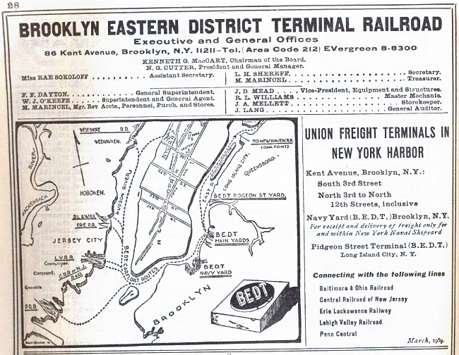
courtesy of
P. F. Strubeck
added 26 Nov 2008
.
.
Accidents, Injuries
and Fatalities
.
Not to appear morbid or dramatic, but sometimes the only way to remember the sacrifices made by railroad employees is to recall the incidents in which they were involved in. Railroading has always been a dangerous occupation, especially so in the early 1900's.
The Brooklyn Eastern District Terminal was no exception to being a hazardous work environment due to its industrial nature, but even it was more so when you also add the switching and marine aspects of employment there. There are a wide variety of incidents to be considered from working at the Brooklyn Eastern District Terminal, which in turn caused any number of injuries or worse: boiler / firebox explosions (burns & scaldings); sinking & capsizings (drownings); and those types of injuries normally associated with the transportation industry: "run overs" (where a person is run over by equipment); crushings (i.e.: between a wall or two pieces of equipment); and of course, slip & falls.
This page was created to consolidate all the reports and submissions from various sources into one location and place them into chronological order, as there were listed rather disjointedly in the "Memoirs" chapter on this main BEDT website. Not an easy task, the only way to learn of these incidents was hours of searching the web, newspaper archives, obituaries, or direct recollection of employees and their descendants.
In later years and in most cases, the Interstate Commerce Commission sent an investigator to (what else?) investigate the incident, especially those involving a fatality. But even this is not foolproof, as several incidents we know of involving a fatality or serious accident, does not appear in the online archives of the I.C.C.
However, like almost all other documents relating to the operations of Palmer's Dock and Brooklyn Eastern District Terminal, these reports have not yet turned up for review. In those cases where reports and newspaper articles have been located for a specific incident, a link is provided to those documents.
There are however several promising leads in finding accident reports of the BEDT in at least two repositories of I.C.C. documents, those being the National Archives in College Park, MD; and the Kheel Center at Cornell University, Ithaca, NY. Naturally, all readers are encouraged to continue to submit information on currently unlisted incidents, or to submit specific dates and / or facts about those incidents that are listed.
.
In this chapter, there are now two films (converted to digital format) of the Brooklyn Eastern District Terminal in action!
The first video was a 16mm with no sound taken by Mr. Robert B. Hart on Tuesday, July 2, 1957. I met Mr. Hart at the Clark, NJ "Mother Seton H.S." Train Show on 06 March 2011, and he informed me he had this footage. Mr. Hart already had it converted to digital, so he mailed me the DVD and I received it 15 March 2011. In this video, you will see #11 and #16 in operation.
The second video clip was 8mm with no sound. I acquired it back in 2006. The original film footage was taken by Gerald Landau, and I acquired it from Norm & Marie Wright. Unfortunately, the date that the original film was "shot" is not known. In it, we see #10, #12 operating with #11 is already out of service and being cannibalized. With #10 still in service and #11 out of service would place the date of the video after September 1958 (when #11 was taken out of service) and before October 1962 (when #10 was taken out of service).
 |
.... |  |
|
July 2, 1957 |
ca. 1958-1962 |
Due to the enormous content of information and photographs compiled regarding the rosters of Palmer's Dock, East River Terminal Railroad and Brooklyn Eastern District Terminal Steam & Diesel Locomotives, Tugboats, Carfloats and Non-Revenue Equipment; this main website was getting slow in loading. Therefore at the request of those loyal visitors; those images ansd rosters are now on their own pages.
These can be accessed through the following link:
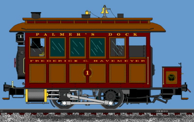
B.E.D.T.
Property & Operations
Photographs
.
.. This page is a compilation of photographs showing the various buildings, structures and property serviced by the Brooklyn Eastern District Terminal throughout its history.
Of particular interest are the recently acquired W. R. Harrison Terminal Reconstruction & Survey images from 1918 through 1919. This series of 62 images are the best known visual recording on how the Brooklyn Eastern District Terminal appear ed before and during its last major reconstruction. Individual buildings may have been razed or constructed, but these image show a major renovation encompassing most of the Terminal. These images due to thier quantity and size have been published on their own respective page.
.
..
|
W.
R. Harrison Terminal Reconstruction & Survey Image series: |
Assorted Property
Images: |
|
click
here: |
click
here: |
.
.
.
.
Attention Railroadiana Collectors, Auction Houses and Dealers:
I am very interested in procuring any of the Baldwin and/or H. K. Porter steam locomotive builders plates, as well as the ALCo / GE diesel locomotive builders plates or number boards that were assigned to those locomotives, as well as builders plates or appliances (marker lights, compasses, engine telegraph, etc.) from any of the tugboats owned by the Brooklyn Eastern District Terminal.
My personal collection of BEDT Boxcar Seals, Matchbooks, Forms, Letterheads, Maps and Advertising can be viewed here:
.
.
.
Due to the size, complexity and ever expanding contents of the Memoirs chapter of this website, it has been moved to its own page.
You may continue to view the Memoris through the following link or the link in the subpage (file cabinet) directory at the top of this website:
.
.
...
.
This chapter is
for all those BEDT fans
out there building models. All are invited to submit .jpg photo(s) of
their
BEDT models! Models from any era, in any scale, and in any phase of
completion
are welcome. All submissions will be listed on a consolidated subpage
with
other submissions and linked in this chapter and in the Main Index.
With your submission, I request that you
please include:
.
To submit photos of your model, for more information or for suggestions, please email me: bedt14@aol.com
.
click here:
|
|
.
.
For those of you who are unfamiliar with some or most of the terminology used in this website, the following link will take readers to a glossary of definitions indicative to rail - marine terminal operations:
.
Glossary of Rail / Marine Terms & Definitions
.
.
Photographs & images
courtesy of the archives
of:
|
Art
Bink |
Hans
Kuring John LaBarre Gerald Landau Walter Matuch Alan Miller John S. Murray Benjamin W. Schaeffer Peter Schmidt Joseph Siatta Pete Smith Rich Taylor John Testagrose Mike Woodruff Frank Zahn Ron Ziel |
| Kalmbach
Memorial Library - locomotive
images New York Public Library - Sanborn Fire Insurance, E. Belcher Hyde & Bromley Property Maps; images New York State Library - maps and images New York Municipal Archives - maps and images Southern Methodist University / DeGolyer Collection - Baldwin Locomotive Works, Order Specification Sheets & Drawings Hagley Museum & Library - Vulcan Iron Works University of Pittsburgh - H. K. Porter Build Records, Extra Orders and Documents Canada Science & Technology Museum - H. K. Porter Locomotive Erecting & Specification Drawings Railroad Museum of Pennsylvania - Baldwin Locomotive Works documents University of Missouri - St. Louis - John W. Barringer III National Railroad Library USACoE Ports & Facilities Maps 1932 University of Texas - Austin - USACoE Ports & Facilities Maps 1942 HathiTrust Digital Library - USACoE Port Maps & Legends |
|
Bibliography, Resources
& Suggested Reading:
|
New
York Times, various issues and years |
Please note, I am not responsible for inaccuracies published by other sources.
For more information and other websites about B.E.D.T. History & Locomotives: please visit the following links:
Florida Rail Road Museum [formerly known as FGC Museum] (#12)
Strasburg Railroad (#15)
Dave Keller's LIRR Website (LIRR history)
Steve Lynchs' Long Island Rail Road Links (LIRR & Other RR's on LI)
www.SteamLocomotive.Info (all steam locomotives)
Morning Sun Books (various authors and topics on railroad in the New York City Area)
Please
note, I
am not responsible for
inaccuracies, erroneous information and inactive links published by
other
sources,
and this links and their contents are furnished
here for your
convenience.
Daniel
Aull
for use of his bricked up BEDT doorway arch photo
Kurt
Bell
information, access to archives and copies thereof regarding BEDT
documents
in Railroad Museum of Pennsylvania
Sam
Berliner, III
for information, suggestions, feedback and improvements regarding this
website;
Art
Bink
for information, photos and sharing his "other" Bill Paxton BEDT
Painting
Robert
Brendel
for making available the 1927 ICC Valuation Report, Boiler Reports and
other
documents
Michael
Brusich
for making available his grandfather's BEDT documents and newspaper
clippings
on the Invader
Gene
Collora
for use of his 11" x 14" action photos in his archives and for his
continuous "wet" (dark room) printing of the BEDT negatives I continue
to
purchase
Tim
Darnell
for the gracious use of his BEDT archives
Robert
Diamond
for ownership documents on BEDT #16
Bernard
Ente
for advice and
suggestions;
Harold
Fagerberg
for the use of his photographs
Jose
Feliciano
ALCo S1 information & specifications
Thomas
Flagg
Warren Street Terminal information and track maps, Palmer's Dock
& BEDT
history
continued
research and contributions
to this website,
financial assistance
Tom
Hendrickson
for sharing his recollections, making available his
father's (a
BEDT Conductor) photographs, pre-1906 history research
including locating
an image
of Lowell Palmer,
and ongoing research and contributions to this website
Steve
Grande
for hosting my websites on trainweb.org and for providing the necessary
space
to host the larger size images
Richard
Glueck
for his BEDT art, goat jokes, immoral support and the fact he is a true
science
icon
(and a testament to the missing link theory)
James
Hurley
for contributing his BEDT image archives
Dave
Keller
for the images and information on #6, #7, #8, #9; feedback,
additions,
suggestions & BEDT diesel roster,
and for his continuous "wet" (dark room) printing of the BEDT negatives
I
have accumulated and continue to purchase
the
Linscott
Family
for allowing use of Roy Linscotts' Jr. Locomotive Notes.
Please visit their website at
www.linscottstrains.com
Steve
Lynch
for
proffering my websites on his LIRR
History website
Gregg
Mahlkov
for generous use of his photographs
(please note - all Mahlkov photos are free domain and are not
copyrighted)
Lori
Harrison
Miller
great-grandaughter of Einar Boe, marine engineer killed in Invader
sinking
of June 1930
for providing newspaper articles of the sinking and obituary.
Conrad
Milster
use and scans of his BEDT marine & locomotive images
Tim
Moore
Baldwin builders specifications & data for the East River
Terminal
locomotives
Joel
Norman
former NYD employee
operational information and historical data for NYD / BEDT operations
Deborah
M.
Pickering
who has found out what a being "BEDT widow" is all about
Fred
Rasmussen
for ownership history on #16
Bob
Rickey
for furnishing National Archives images and newspaper
articles of Wallabout Market
opening
Benjamin
W.
Schaeffer
for his intentsive notes from his visits to the BEDT for many years -
rest in peace my friend
Pete
Smith
for submitting his father's great color BEDT photos from 1958
Allen
Stanley
his comprehensive locomotive builders records and information
Barry
Stone
for years of service data on BEDT Invincible
Paul
F.
Strubeck
co-author, current photos of BEDT #16, BEDT diesels, ALCo S1 diesel
information,
proof-reading,
suggestions, revisions and ongoing research and contributions to this
website
Rich
Taylor
for the use of his photographs
W.
Jay
Wanczyk
for 1960's BEDT operations information, the 1907 Bromley map, Palmer's
Dock
history & research
and
ongoing research and
contributions to this website
Mike
Woodruff
for his photo contribution of BEDT 25 pre-Bicentennial paint scheme
Norm
& Marie
Wright
for the use of Gerald "Jerry" Landau's archives;
Robert
Yanosey
for the use of his photos and reprint permission of photos in his
Morning
Sun Books publications
Lillian
Zahn
for
allowing me to procure and use
Frank Zahn's NY
Industrial / Terminal Railroad photo archives
Jessica
Ziel
for making her uncles archives available to me for use on this site;
Ron
Ziel
for information on his ownership of #12, memoirs and photo histories
Cynthia
Franco
of the DeGolyer Library of Southern Methodist
University
for access to and furnishing photographs from the Everett
L. Golyer
Jr. railroad photographs archives
Wendy
Schnur
of the G. W. Blunt Library of Mystic Seaport Museum &
Library
their research and archive staff for copying and furnishing BEDT vessel
history
& information
Marcia Mordfield
of
Ingenium - Canada Museum of Science & Innovation
Assistant
Archivist - Collections
& Research
and perhaps most importantly, to:
Joseph
Roborecky
former BEDT employee
for taking the time to be interviewed, share his memories and explain
BEDT
operations at length
and ongoing research, contributions and assistance in maintaining this
website
co-author, I.T. knowledge & advice and all around therapist
.
This website is respectfully & proudly dedicated to my father Stan.
Quite simply, he is solely responsible for my interest in railroading, and for that I shall forever be indebted.
See you at the next stop dad.
|
.
.
Will there ever be a published
book of this website?
For those of you who have not yet realized it, this website is a labor of our affection for the topics covered within. The co-authors of this website spend quite a deal of our free time on it; improving upon it, adding to it and correcting errors as we either found them or as they were pointed out to us.
Many of you loyal readers and rail-marine fans have suggested, and rightly so; why not publish this website into a printed book? More than once the thought has occurred to, and quite frankly the thought flatters us. While quite honestly we know we are capable of drafting the manuscript and having it printed; there are a few good reasons we have chosen not to.
.
Existing Scope:
This website started out in mid-2004 at less than 50 kilobytes, with maybe about twenty-five very primitively scanned and highly compressed images of "steam locomotives only" of the BEDT and hosted on AOL hometown an early web hosting space offering 12 megabytes of free space.. 12 megabytes!
As of May 2007, the website was expanded to include the other Brooklyn rail-marine terminals: Bush Terminal, Jay Street Connecting and New York Dock, and broke 300 kilobytes - text only. This figure does not included the photo files which were now enlarged, minimally compressed and now included diesel locomotives, miscellaneous equipment, tugboats, carfloats, and property. In March of 2008, the main page broke 500 kilobytes - text only.
Here we are in 2016 and the BEDT main page alone is just under 1 megabyte. The entire website, which now covers over 40 locations throughout the five boroughs of New York City, is 13 megabytes (again, text only). Add to this figure, over one thousand images and document files; a few of which are .pdf files but for the most part are minimally compressed .jpg files and now beginning to be sized for wide screen monitors.
In all, text and graphics; this website
is now comprised of in excess of 950 megabytes. That is only 50
megabytes
shy of a gigabyte or 1GB! (And you want us to print this to a book!?!?!)
To even consider printing something of this scope,
a multi-volume
set of books would at the very minimum, be necessary. To keep with the
detailed
nature of this work, numerous fold-out inserts per volume, at least 2:1
and
in most cases 1:1 would be needed to accommodate the detailed property
and
track maps AND keep them legible. Naturally, this set of books would
have to be
a
color production on good quality gloss paper, all of which
leads to
a hefty production cost. Reflecting on what a printed set of the
Encyclopedia
Britannica (on pulp paper and 99% black & white) way back when,
no wonder
why it cost so much and it was mass produced!
Let us say we were able to keep the retail unit cost at around $300 per set (a very conservative figure). We came up with this amount by comparing the retail cost of several (in print) releases with an average retail of $60 retail per issue, approximately 150 pages per issue multiplied by six volumes. All volumes of which to be published and released simultaneously. Obviously we can't go door to door selling sets of books of this website, because if we were fortunate enough to sell a multi-volume set at $300 a set to every rail-marine fan, industrial archeologist, and local historian who would be willing to spend that amount; we might, might; be able to sell 250 units.
It simply is not worth the production cost. Ours is a limited niche market. Even if we were to limit the coverage to a one or two volume offering with a few paragraphs on each location, you lose what this website is all about: a multi-disciplined, comprehensive and authoritative area of coverage.
Anything less and you get what you have every few years: a "coffee table" picture book. Anyone can throw a few dozen photos into a book with a date and maybe a title underneath, put their name on the cover and sell for $50.
But no one is going to get rich. And it certainly will not be comprehensive. Nor will it make the New York Times best seller list or Oprah's book club.
.
Photo Contributions - Not for profit vs. Commercial:
Another important reason against a printed book is in regards to the photo contributors. This website is non-profit and non-commercial. We see no income much less profit from its existence. Matter of fact, the research that is incurred with a task of this magnitude sometimes leaves us strapped for funds (we have other hobbies and other obligations) and quite honestly, the website operates in the negative. In any event, this not for profit status allows us some latitude in publishing photographs from established archives and repositories.
For
many of the individual
images, to now go back and obtain written copyright
permission from
each and every contributor now would be time consuming not to mention
expensive,
and as some of these contributors may now want some form of monetary
compensation
for themselves. We also feel we would also lose some of the "good
faith"
photographic contributions made in the spirit of railfanning. ("I'm
sending
these to you to use on your website provided you don't sell
them. Just
put my name under them.")
Essentially, if we published a book, we
would be selling
those photos. And it changes the game, so to speak. So it is by far
easier
to keep this a friendly contribution non-commercial based website,
where
we all share in the glory of the photographs and information, located
in
one place and very easy to access.
.
Accuracy & Content - In good faith:
Considering that in a historical reference such as this; some dates are estimated, names may not be spelled correctly or locations misstated, and information from previous sources is learned to be incorrect. In some instances we unintentionally screw things up, such as transpose information, data, dates, etc. In short, the electronic format of this website allows us the immediate opportunity to correct those mistakes when they are discovered.
We like to think of ourselves as perfectionists and we have spent many a sleepless night editing to get things just so, in regard to text, images and illustrations. Sometimes we work on it for hours only to tear it down and start over, because something just does not seem or look right or the continuity does not "flow."
In this electronic format, when we receive a correction, we correct the appropriate error on the webpage, make a note in the revision list and upload. After 90 days, the oldest revision is removed from the revision list and forgotten about, because the correct version is on display. That's it, any errors have been fixed with a few keystrokes.
Unfortunately with a printed object, nothing can be done about an error unless it is decided to print a second volume or use an online addendum, and then we can only hope that the book purchasers find and take the time to review.
.
Accuracy
& Content - In bad
faith? Not!
Another reason, which we have to say is quite important to more than one of us (sometimes more so than other reasons), is the accuracy and veracity of the information contained within this website.
This day and age of the home office publishing suite, has simplified the way in which to put together a book or website, add images, print / publish and offer it for sale. While most works have been well researched, well authored and presented; inevitably this do-it-yourself publication trend has seen the proliferation of overnight historians and sometimes worse: those authors so obstinate to the point that they will not accept facts and observations in evidence, and of which that have been borne out time and time again through genuine research and documentation. So they print their version. While most of us take it in good stride, it does remain a thorn.
Unfortunately, the numbers of these contradictory information authors are increasing, because of the ease in which they can publish their slant or opinion and of which can be seen or heard easily in a world wide forum. After all, that is why it is called the 'world wide web'. Inevitably enough people read this bad information and becomes accepted as a fact. This bad information then circulates and the new reader (who justifiably accepted that the author did his research and presents fact and not fiction) comes along and accepts that information as fact. (I saw it on the internet - it must be true. Abraham Lincoln, 1866).
While this type of bad information is the exception and not the rule; it is a problem in this field (and I am quite sure of others). Rail transportation is a popular subject. Rail-marine operations in New York Harbor? Even more so. Most rail enthusiasts are stubborn to the point of, "If I didn't see it, it didn't happen".
Add to this proliferation of AI generated posts in Facebook Groups. Slop images and bad info.
In short, what you can be assured of,
is that this website in its electronic format, and of which is made up
of
several co-authors and extremely knowledgeable contributors in the
various
fields covered by in this website including but not limited to
railroad,
marine, civil engineering, mechanical design, construction, municipal
planning,
history, etc. This "consortium" approach of sorts has the effect of
leading
all of the contributors to be open-minded and very careful in our
research
and subsequent conclusions, and this group effort so to speak negates
any
one of us intentionally publishing erroneous information out of
obstinance.
As stated above, once information is published to
a printed
and bound book, again: that's it. It's printed: erroneous conclusions,
conjecture, opinions and all.
.
Image Size:
As stated in the first reason above, one
of the drawbacks to a bound / printed book, is size limitation on
graphics,
maps, etc. While a foldout can be pasted into a book, production costs
are
very expensive. Some of the track maps used on this website are 3 feet
by
5 feet! And there are more than just a few that illustrate the yard
layouts
over the decades.
With this website however, we can scan oversize
images and put
a link to it, where you as the reader can reference that oversize
image.
Then you can enlarge, reduce, zoom, etc. using computer functions
(control
+ / control -) on the portion of the graphic you desire.
The same applies to standard images of equipment.
A large image
scan reveals details not normally seen in a reduced image size on a
printed
page. But there is a downside to good quality images: image use without
due
credit. But again, this is the exception, not the rule. And as most of
us
rail enthusiasts pretty much travel in the same circles, so you really
can't
get
away with "hijacking" an image for too long.
.
Additions and expansion:
As this page increases in publicity, more and more data arrives from several different sources for us to add. In a printed format and once published, we cannot add a new chapter, location or anything else we deem important, i.e.: a previously undiscovered connection or an influential event, or perhaps that yet undiscovered photo of a previously unknown piece of equipment. Any of these would warrant an immediate update to this website and we would not have that luxury with a printed and bound publication.
With this electronic format, as mentioned with corrections, we are free to expand without the need of returning to a printer and publishing a new edition.
.
Exposure - More than just railfans:
As rail transportation enthusiasts ourselves, we all are aware that a publication on the subject can usually be found at a railroadiana show. Maybe, if the book is really good; you may see it on a shelf in a chain book store if they have a local history section. An older book may be out of print and obtainable only in a used book store. But what these locations do not offer is the availability to the general public, such as the descendant of a railroad employee or even a retired railroad employee who is not seeking the book but some obscure bit of information.
What I am trying to say is that with a
printed book, you will only encounter it in a select venue. This
website
in contrast, which is published electronically and searchable by any of
the
text within the website on the internet, leads to many more
opportunities
to have these works "found", read and commented on such. As former
employees
who have no such interest in railroads or navigation, the neighborhood
they
once worked in may very find this website simply by searching the
internet
for a general term such as the company they were employed by
or by something
so specific as an address.
We can state for the record that we know this to
be true, because
to date dozens of employees and in cases, the descendants of employees;
have
contacted us via this website, whether to share personal reflections,
images
and history on their tenure with a particular company or to seek
information
on what their anscestor did for the company. From the obscure
Phelps-Dodge
employee to emails from descendants of the principals of those
companies
such as American Dock, Pouch Terminal and Bush Terminal.
Former rail industry employees like our very own co-author Joseph Roborecky who found the website and contacted us, were then able to gave us insight to how the job was done. And even better joined the ranks of authors and reseachers that make this site what it is! Emails from great-great grandchildren looking for information on an ancestor that worked for a railroad; or further information on an ancestor who unfortunately died on the job due to an accident. Emails from attornies researching or representing an injury case and need to know the technicalities of break bulk cargo. Emails from parks planning commissions on checking the historical accuracy of their displays. Emails from a New York Times reporter on the dates of operation or other incongruous details for a column they are writing.
Why, we have even learned, that the general management of an active railroad uses information from this website in regards to their daily operations in training materials for new hires. While we used to publish the letters as we received them on the bottom of the website when it was first started, we ceased for space reasons and instead began the inclusion of a guestbook. Now we regret that. But you can go through the guestbook yourself and see who has added their name to the readers of this website.
It is very rewarding to hear from these people from all walks of life, young and old, even when their letter is nothing more than "I used to work for _____ back in _____. Your website brought back a lot of memories. Thanks for the effort!"
It is even more rewarding when we follow up with them, and through the course of conversation get more information from them about an operation, then are able to publish it here almost instantly and share it with you all. We find it difficult to say we would have obtained these connections and this information with a limited circulation specialty subject book.
.
In conclusion:
So, all things considered: to all of you who find this website; no matter what your preferred field of interest is, whether it be railroad, marine, rail-marine, civil planning, the evolution of the City of New York City, or more specifically your old or new neighborhood or even if you were bored, found this website by chance and need to tune out the rest of the world; please accept our decision in keeping this an electronic website / eBook format.
We can only hope and ask for your understanding in our decision and support it...
Enjoy!
Like
what you see?
Suggestions? Comments?
Click here to sign the Guestbook!
Please click on the book below and feel free to sign the guestbook... Leave a comment or suggestion if you would like!

.
.
Please click here to learn about the AUTHOR
.
.
May the little railroad with the big name live on in our memories and
never
be forgotten.
|
|


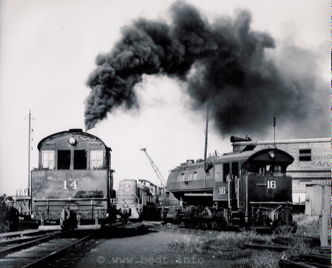
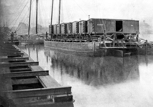
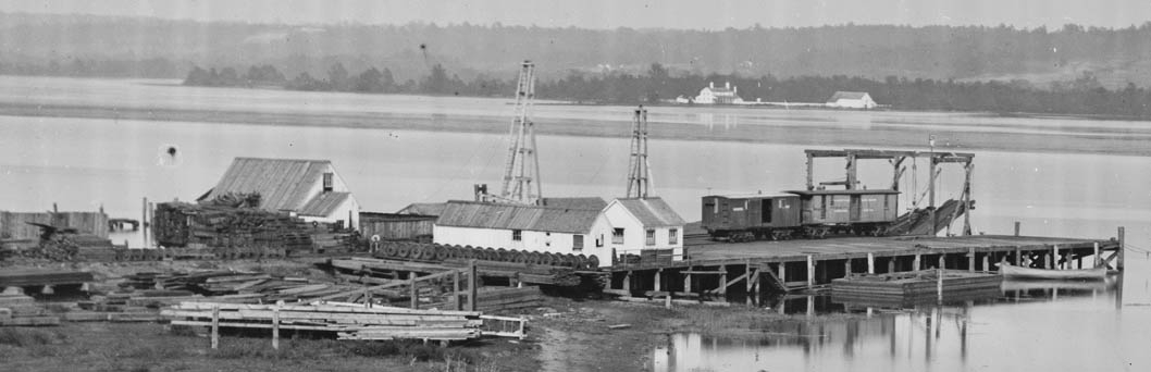
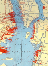


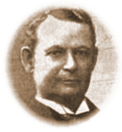
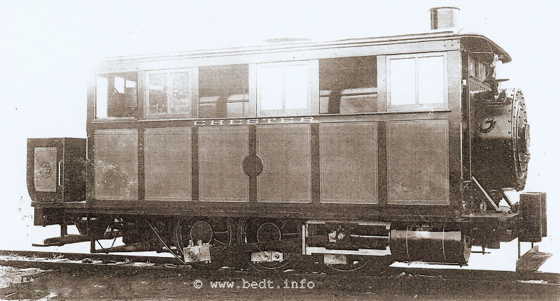

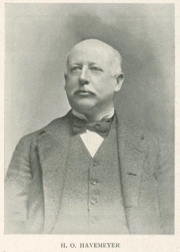
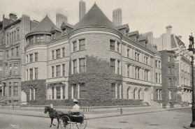
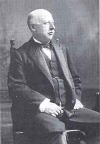
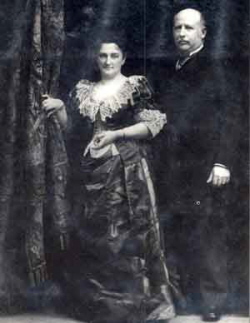
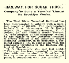
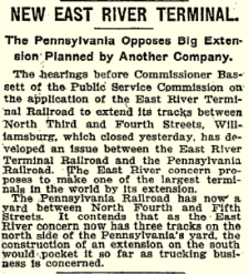
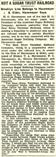
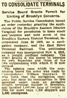
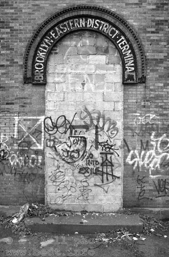
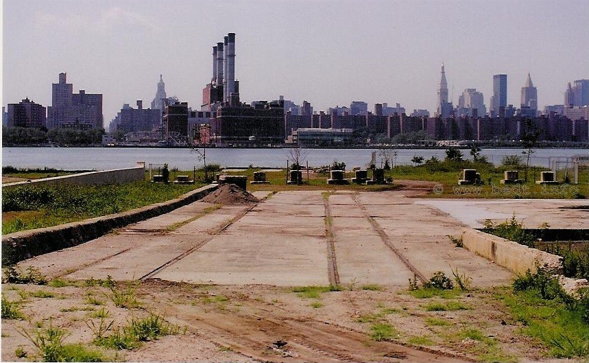
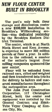
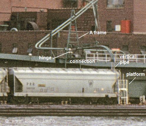
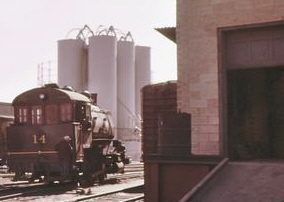
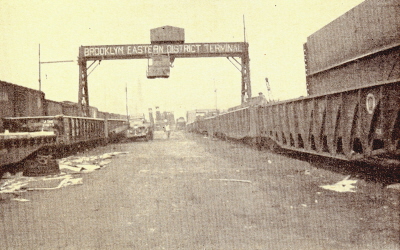
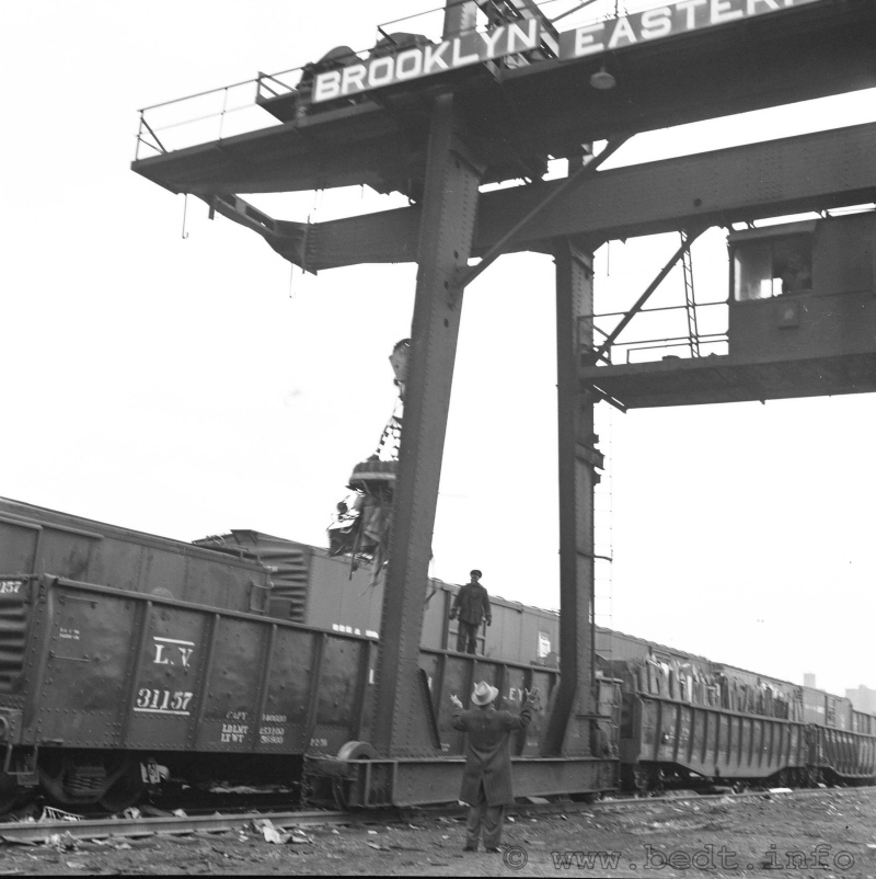
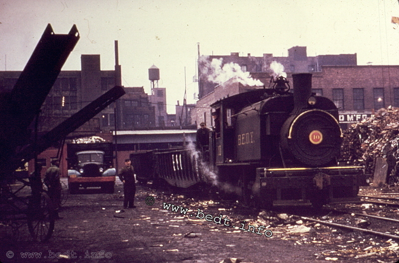

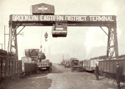
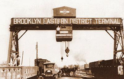
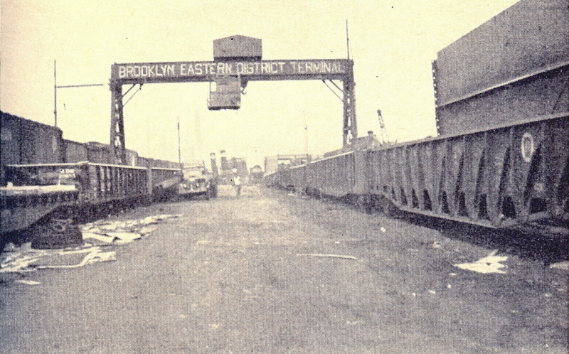
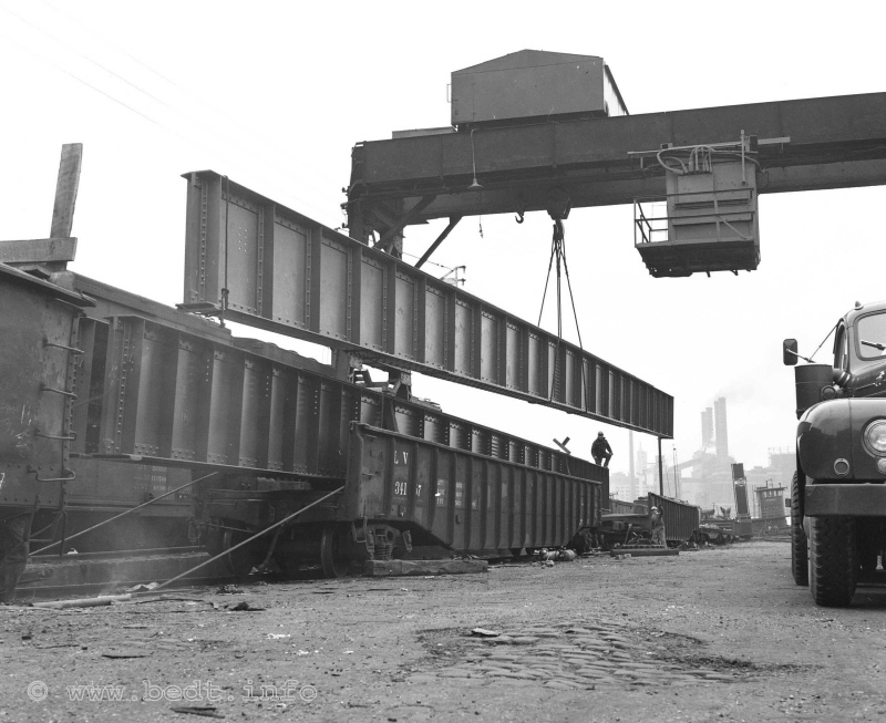
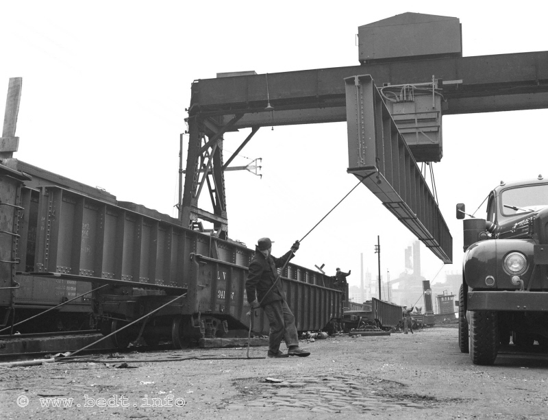
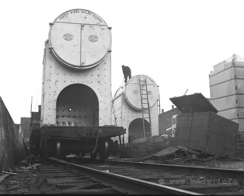
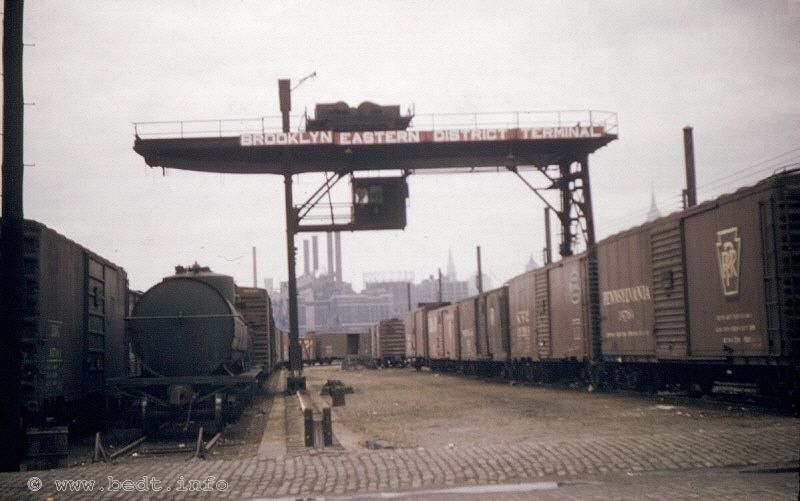
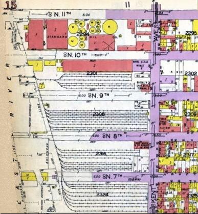
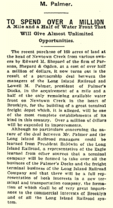

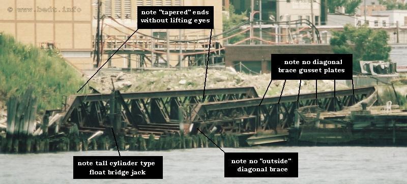
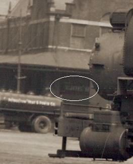
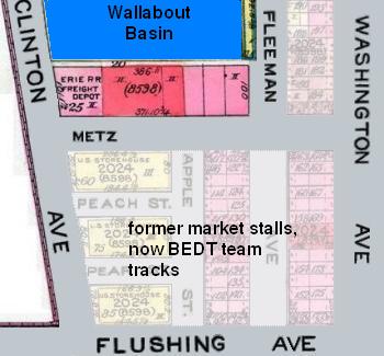
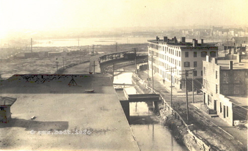
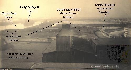
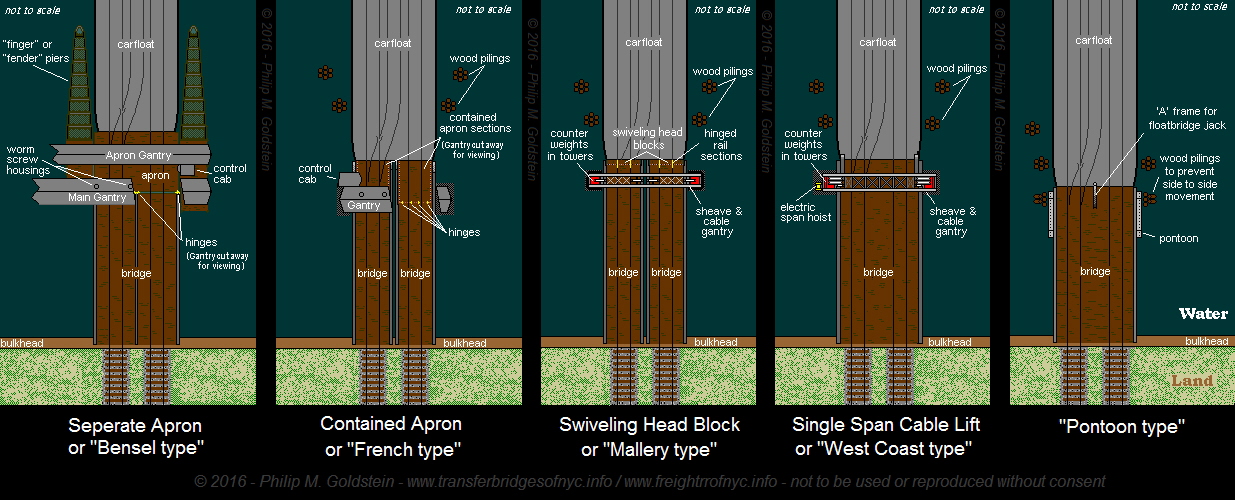
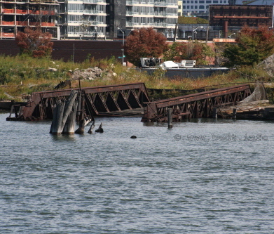
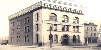
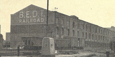
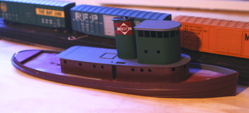
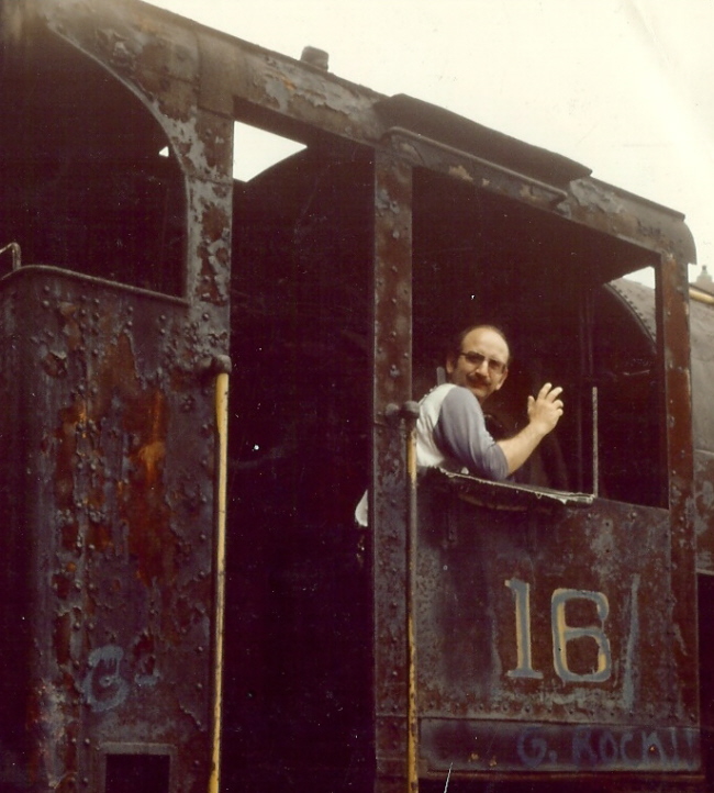
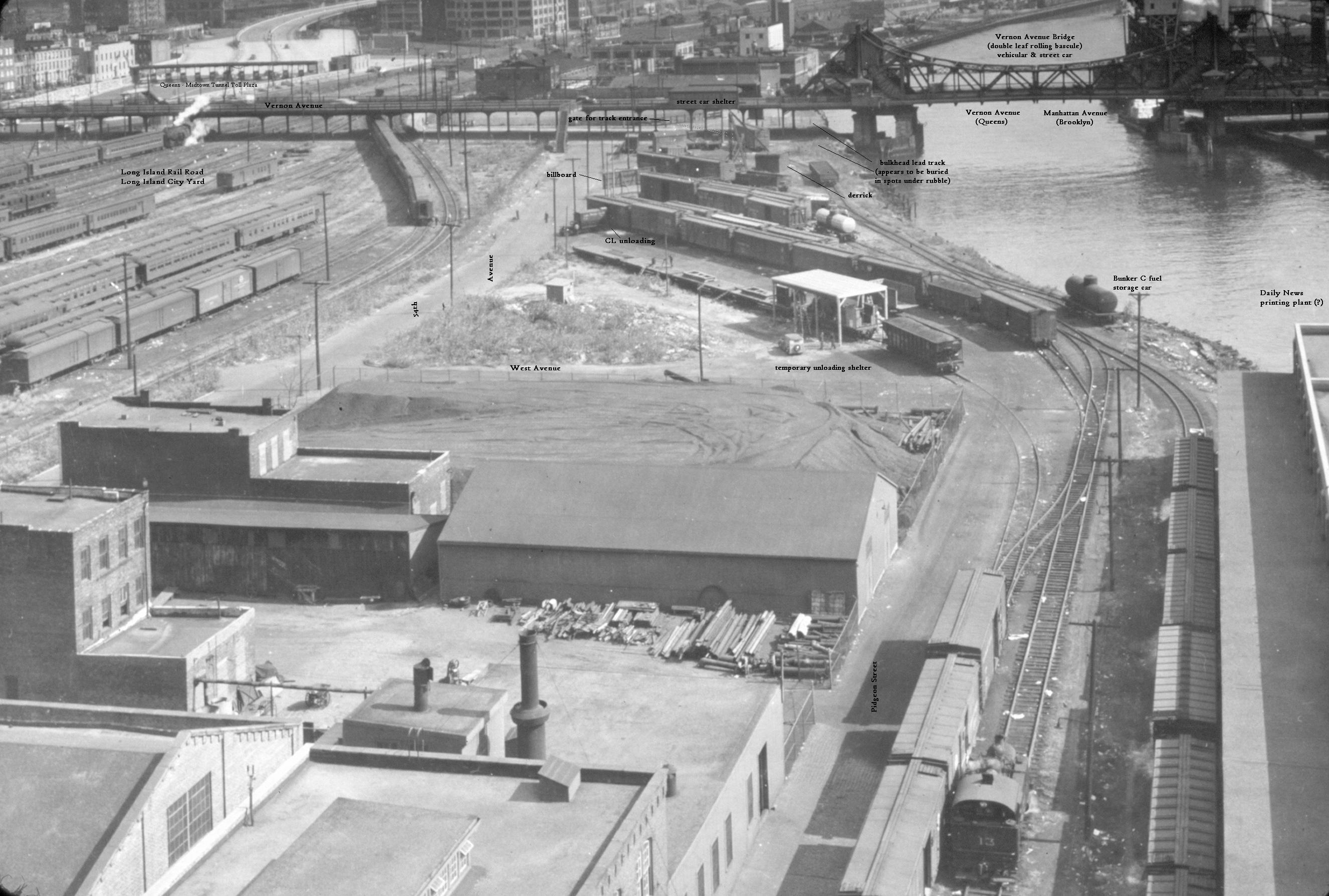