TrainWeb.org Facebook Page
B&O Metropolitan Branch Photo Tour


B&O Metropolitan Branch
Modern day photo tour

Accompanying each photo below are:

Click a photo to see a larger view. Please send your comments and corrections to Steve.


<< Previous (east) | THIS PAGE: Rockville to Washington Grove | Next (west) >>

Pyramid
Photo courtesy Dave Hiteshew

Pyramid
Mile: 16.4 Date: Aug 2008
Ease: A View: N
Area: B+ IC2:
Map: Mo 29 D 7 Topographic Maps

This unusual bridge has been sparsely documented. One source reports a pedestrian bridge to Rockville Station had existed in this vicinity since the late 1800s, but another suggests the bridge was added only after a 1936 collision between train and school bus at the Baltimore Road grade crossing. The "Whispers" photo below shows a vehicle crossing it during 1966.

News reports say that bridge collapsed during the early 1970s, and in 1974 was converted into this pedestrian bridge, ostensibly to give children a way to/from St Mary's School without crossing at grade. Who knows the real story? To replace Pigeon Bridge, Viers Mill Road got a new bridge with room underneath for Metro during 1981, and the pyramid bridge was removed around 2010.

Links: 1909, 1920s


Zoom
Photo courtesy Dave Hiteshew

Zoom
Mile: 16.4 Date: Aug 2008
Ease: B View: NW
Area: B+ IC2:
Map: Mo 29 D 7 Topographic Maps

CSX, Metro, MARC and Amtrak all roll through here, with good views of the action from the pyramid bridge or Viers Mill Road. B&O's Rockville Station is shrouded by trees on the left.


B&O 1457
Photos courtesy B&O History Collection
NEW! mid-Nov 2022

B&O 1457
Mile: 16.5 Date: Apr 1969
Ease: A- View: NW
Area: B+ IC2:
Map: Mo 29 D 6 Topographic Maps

Sep 1969 The pyramid bridge and the original Viers Mill Road bridge were visible from Rockville Station, as in these views southeast.

At left, later in 1969, B&O 4534 model F7A and others tote boxcar BO 466572.

Link: 1995


Rockville
Photo courtesy B&O Museum

Rockville
Mile: 16.5 Date: ~1900
Ease: B View: NW
Area: B+ IC2:
Map: Mo 29 D 6 Topographic Maps

The E. Francis Baldwin-designed station that put Rockville on the map dates to the 1873 opening of the Metropolitan Branch. About the time of this photo, the passing siding here was the longest on the branch.

The wooden boards parallel to and outside the rails reduce the trip hazard the ties present to passengers.

Links: 1880s?, ~1905, Ephraim Francis Baldwin


Coal
Photo courtesy B&O History Collection
NEW! mid-Nov 2022

Coal
Mile: 16.5 Date: Apr 1967
Ease: A View: NE
Area: B+ IC2:
Map: Mo 29 C 6 Topographic Maps

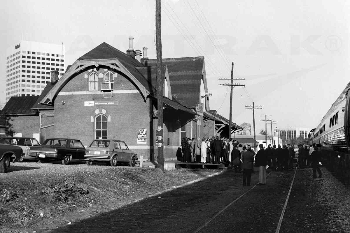
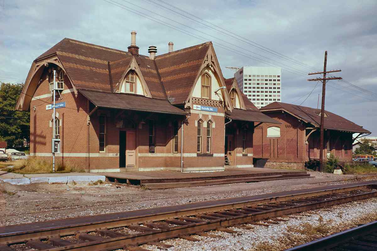
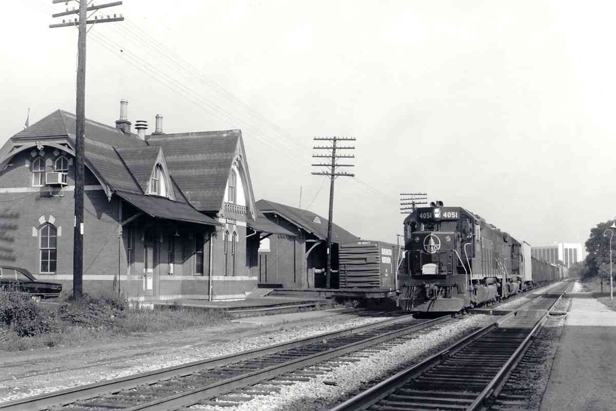
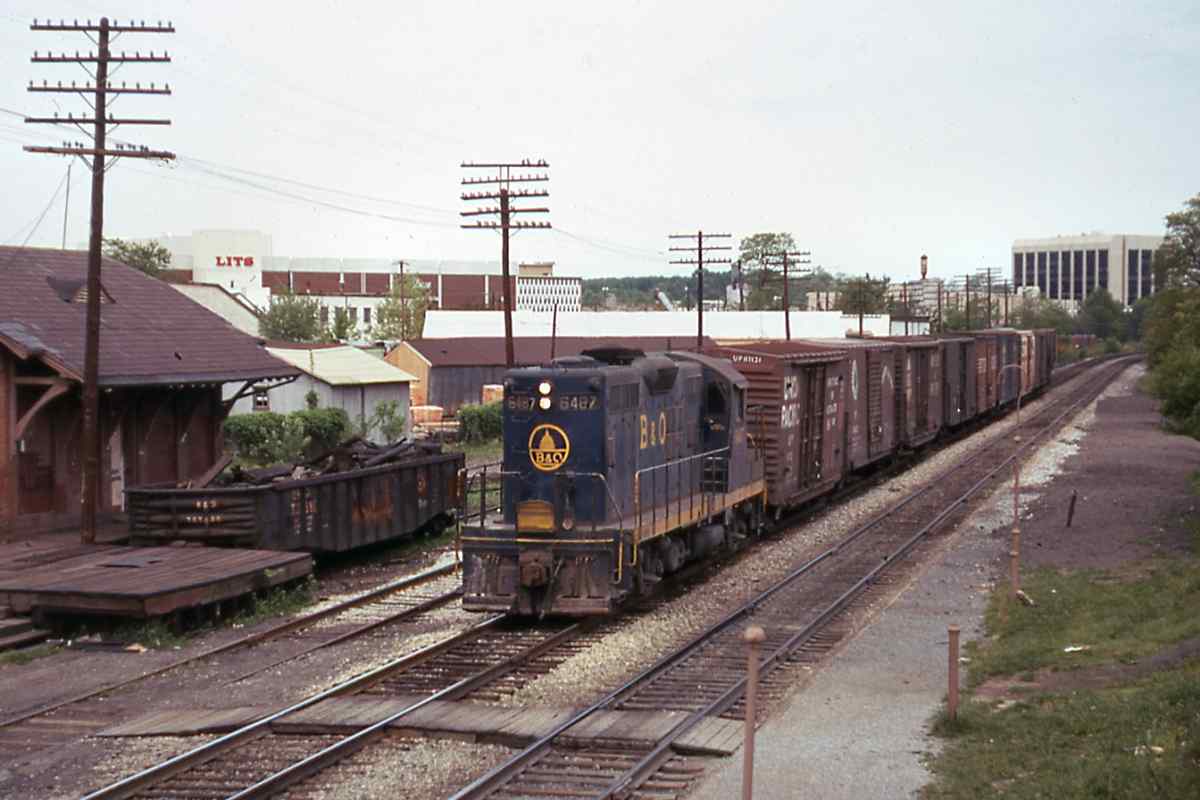
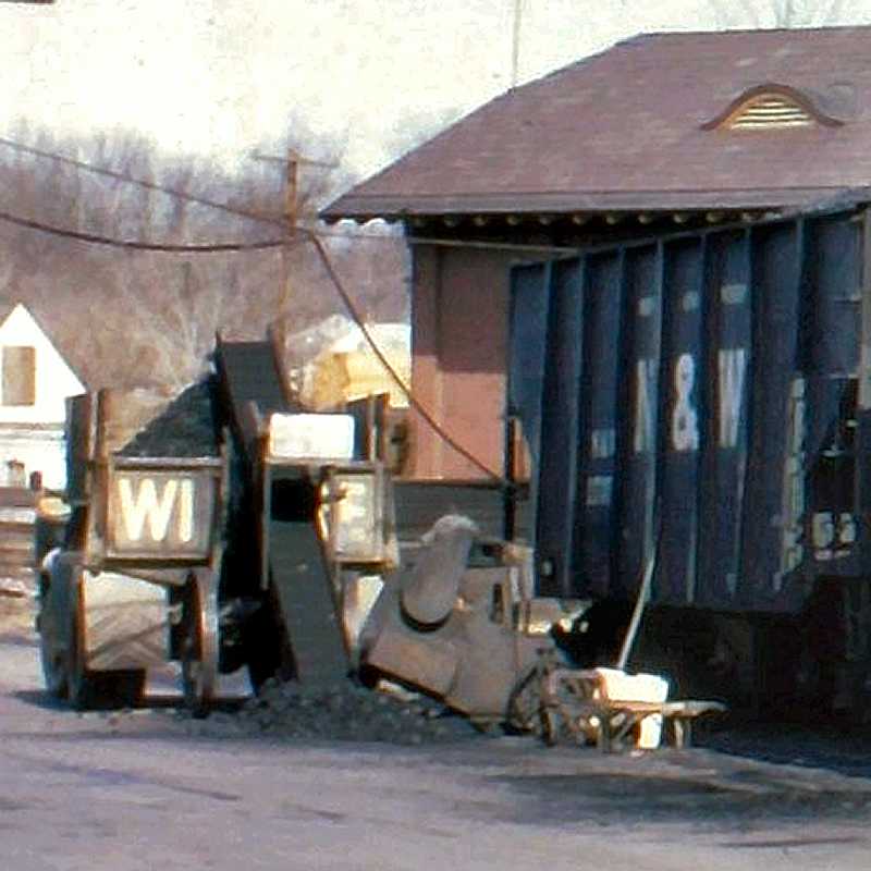
Until about 1980, the railroad would leave loaded coal hoppers behind the station for local end users. Here, coal is being transferred onto a Wire Hardware truck for delivery. Wire Hardware was across Church Street from the station, off photo left; its building has been restored by the Peerless Rockville historic preservation group.

Wire Hardware Rockville This photo introduces several unanswered questions. I am told the rusty, bulky device between the truck and railcar operated conveyors that carried the coal from under the railcar up into the truck. There are about 100 tons of coal in the two hoppers; was Wire the only organization delivering it? How long did these railcars sit for emptying? Most railroads charged demurrage (an extra fee) if a car stayed longer than two days.

Burning coal has a petroleum-like odor, some say similar to diesel exhaust or raw gasoline. What about pricing? Comparing past and current prices of coal is a challenge because pricing varies by coal grade, delivery method, contract size, currency inflation, etc. Anthracite type is preferred because it packs more energy per unit weight than other types like bituminous. Data from year 1900 suggest 100 pounds of bagged coal for home use cost about 25 cents, plus a 10 cent deliveryman tip. By photo time, that price was $1 to $2, or about $15 in year 2020 dollars. A one-time purchase of 100 pounds cost about $100 via Amazon as of 2022. The average US home would need about 32 such bags (3200 pounds) annually for heating. Bulk coal for electricity generation, usually bituminous and lignite, is much cheaper, and as of 2020 cost power plants about $2 per hundred pounds when delivered by the trainload.

Link: Wire Hardware


Sunset
Photo credit W Grosselfinger
B&O History Collection
NEW! mid-Nov 2022

Sunset
Mile: 16.5 Date: Nov 1966
Ease: B View: N
Area: B+ IC2:
Map: Mo 29 D 6 Topographic Maps

By the 1960s the sun was setting on the station. At right is RI 22755, a boxcar of the Chicago, Rock Island and Pacific. (The top of this image has been edited for size purposes.)

The utility pole with a 16-30 sign affixed is the 30th pole beyond milepost 16. The Met had roughly 60 poles per mile, so the sign means we are near mile 16.5.


Station Views
Photo credit HH Harwood
Updated mid-Nov 2022

Station Views
Mile: 16.5 Date: 1972
Ease: B View: NW
Area: B+ IC2: 169
Map: Mo 29 D 6 Topographic Maps

Harwood captured the station during its 100th year on duty as B&O 4051 rolled past. The oldest survivor on the line, Rockville Station spent its final decade at this spot as an Amtrak station. Boxcar BN 189017 waits near the freight house.

1969 December Rockville's photogenic station was, and still is, a frequent subject. Three General Motors cars from 1966 or 1967 help confirm the date of this color view (December 1969), courtesy the B&O History Collection. The Maryland license plate was white on blue at that time.

1976 by Amtrak Pictured at left is likely 1976's inaugural run of Amtrak's Shenandoah that was inspired by the B&O train of the same name. You can find this and many similar in Amtrak's online photo collection.

1978 by LoC Rockville's edition is virtually identical to the station that had been in Silver Spring, though the layout is mirrored. The view at left dates to 1978 and comes courtesy the Library of Congress.

Links: 1978, LoC source photo


Whispers
Photo credit W Grosselfinger
B&O History Collection
NEW! mid-Nov 2022

Whispers
Mile: 16.5 Date: Nov 1966
Ease: A- View: SE
Area: B+ IC2:
Map: Mo 29 C 6 Topographic Maps

Around photo time, passenger rail reached its nadir, and maintenance lapsed, as witnessed by the unrepaired windows of the freight house. The Washington Metro system was in conceptual stage, planned to have fresh, new stations along a line that would parallel the Met. There was no room for this old B&O station, so the demolition word began to be whispered.

Amtrak's 1971 arrival gave the buildings a temporary reprieve, but by 1980 Metro's Red Line needed the space for its own Rockville station. The venerable B&O station seemed doomed.


On the Move
Photo credit John Spano
courtesy Peerless Rockville
NEW! mid-Nov 2022

On the Move
Mile: 16.5 Date: 1981
Ease: A View: N?
Area: B+ IC2:
Map: Mo 29 C 6 Topographic Maps

The Peerless Rockville group stepped up with a plan to save the station. To make room for Metro, in 1981 the station and associated freight house were picked up, moved about 30 feet south, and rotated almost 180 degrees clockwise before being set down on new foundations.

Link: 1981 move


Offices
Updated mid-Nov 2022

Offices
Mile: 16.5 Date: Jul 2012
Ease: A View: E
Area: B+ IC2:
Map: Mo 29 C 6 Topographic Maps

The beautiful structure was granted a new life as offices. Workers inside can Fitzgerald grave watch Metro and CSX action in their backyard, while on break of course.

Also moved here to a family plot less than 300 feet from the station are the remains of The Great Gatsby author F. Scott Fitzgerald. You can impress your trivia-minded friends by knowing the patriotic full name he borrowed from a famous relative.

Link: Fitzgerald's later years


B&O 6487
Photo courtesy B&O History Collection
NEW! mid-Nov 2022

B&O 6487
Mile: 16.5 Date: May 1974
Ease: B View: NW
Area: B+ IC2:
Map: Mo 29 C 6 Topographic Maps

B&O 6487, a model GP9 built in 1956, rumbles past Rockville's freight house. Who recalls what LITS was? The steel of a bridge over Park Road is barely visible at distant right.


Park Road
Photo courtesy Dave Hiteshew
NEW! mid-Nov 2022

Park Road
Mile: 16.7 Date: Aug 2008
Ease: A View: SW
Area: B+ IC2:
Map: Mo 29 C 6 Topographic Maps

An original, unpaved single-lane underpass with stone abutments that connected Stonestreet Avenue and Hungerford Drive was upgraded during the mid-1950s to carry Park Road under the railroad. The arrival of Metro circa 1980 prompted another upgrade to that seen here.


Boxes
Photos courtesy Dave Hiteshew
Updated mid-Nov 2022

Boxes
Mile: 17.1 Date: Aug 2008
Ease: B View: NW
Area: B+ IC2:
Map: Mo 29 C 5 Topographic Maps

Harsco 6700S Beyond the station in the Lincoln Park area, a collection of aging equipment boxes lines the tracks near what remains of what CSX calls its Westmore Siding. At photo time the siding hosted a Harsco 6700S tamper that lacked CSX labels, so may have been a rental.

Ahead, Unity Bridge opened in 1999 for pedestrians.


Hungerford Drive
Photo courtesy Dave Hiteshew

Hungerford Drive
Mile: 17.4 Date: Aug 2008
Ease: A- View: NW
Area: B IC2:
Map: Mo 29 B 4 Topographic Maps

From Unity Bridge we can spy the western limit of the siding. On the left Hungerford Drive traces the eastern edge of the Rockville Campus of Montgomery College so students can drag race Metro.


Offloading
Photo courtesy Dave Hiteshew

Offloading
Mile: 17.8 Date: Aug 2008
Ease: B View: E
Area: B+ IC2:
Map: Mo 29 B 3 Topographic Maps

Suburban Propane is one of CSX's active customers here. The special bays facilitate tanker offloading.


MT 200604
NEW! mid-Nov 2022

MT 200604
Mile: 18.2 Date: Feb 2022
Ease: A View: N
Area: B IC2:
Map: Mo 29 B 3 Topographic Maps

CSX First Aid kit From time to time, various MoW equipment can be found resting on the former Devlin Lumber siding. Some MoW units have a First Aid kit.

There's something oxymoronic about a "Safety is a Way of Life" reminder on a First Aid kit, since with 100% safety the kit would not be needed. I suppose to someone bleeding it's more palatable than "Hey, we told you to be careful."


CSX 5288
Photo courtesy Dave Hiteshew

CSX 5288
Mile: 19.0 Date: Aug 2008
Ease: B View: NW
Area: B+ IC2:
Map: Mo 20 A 13 Topographic Maps

Ack! The railroad was supposed to put engine 1919 in the lead. Heads will roll. Derwood Station had stood on the left.

Link: CSX 1919


Derwood Station
Photo courtesy Montgomery County Historical Society

Derwood Station
Mile: 19.0 Date: ~1910
Ease: B+ View: S
Area: B+ IC2: 170
Map: Mo 20 A 13 Topographic Maps

Representative of B&O's smaller stations / depots was this one at Derwood that a B&O schedule places at mile 19. The station survived until it and the nearby Schwartz Mill were both razed by fire in 1954; all artifacts of it were erased when Metro overlaid the site during the 1980s.

The grade crossing in the photo has been eliminated, but had been for what is now Paramount Drive / Chieftain Avenue.


Derwood
Photo courtesy Johns Hopkins University
NEW! mid-Nov 2022

Derwood
Mile: 19.0 Date: 1951
Ease: View: N (up)
Area: IC2:
Map: Mo 20 A 13 Topographic Maps

A big X of roads and rails on this low-resolution aerial marks Derwood's primary grade crossing during 1951. The station is the small dark rectangle in the southwestern quadrant, while Schwartz Mill is the brighter, larger block in the southeast quadrant. Smoke from an eastbound steam engine wafts north of the station.

Link: Short History of Derwood


Schwartz Mill
Photo courtesy Lee B Smith collection
NEW! mid-Nov 2022

Schwartz Mill
Mile: 19.0 Date: 1948
Ease: B+ View: N
Area: B+ IC2: 284
Map: Mo 20 A 13 Topographic Maps

Eastbound B&O 5080, a 4-6-2 steamer built in 1911 by Baldwin Locomotive Works, pauses at Derwood Station and Schwartz Mill. The bright tongue sticking out of the ground in front of the locomotive is probably milepost 19.

Link: MHT inventory (PDF)


CSX 854
NEW! mid-Nov 2022

CSX 854
Mile: 19.1 Date: Feb 2022
Ease: B+ View: NW
Area: B+ IC2:
Map: Mo 20 A 13 Topographic Maps

These trash containers set out on the main by the Shady Grove Transfer Station need hauling to Dickerson, an assignment this winter day for CSX 854 and 3094, here seen heading away from the camera.

Change for: Trash Pickup sequence


CSX 7515
Photo courtesy Dave Hiteshew

CSX 7515
Mile: 19.2 Date: Aug 2008
Ease: B View: NW
Area: B+ IC2:
Map: Mo 20 A 13 Topographic Maps

Eastbound at Redland Road, over a mile of autoracks give new cars their first miles, without it showing on their odometers. CSX 7515 is a GM model C40-8, colloquially known as "Dash 8", built May 1989.

Meanwhile, a distant CPL watches mirage-like at the crossovers despite the summer afternoon heat. Unseen on the left, Metro's Shady Grove station terminates the Red Line.


CPLs
Photo courtesy Dave Hiteshew

CPLs
Mile: 19.5 Date: Aug 2008
Ease: B- View: NW
Area: B+ IC2:
Map: Mo 19 K 12 Topographic Maps

Three signals with a similar sense of duty keep the first CPL company. A siding splits off on the left, then splits a few more times... perhaps there are some trains over thataway.


Container Yard
Photo courtesy Dave Hiteshew

Container Yard
Mile: 19.5, 0.4 siding Date: Oct 2008
Ease: C+ View: S
Area: B IC2:
Map: Mo 19 J 12 Topographic Maps

Sure enough: not only trains (CSX 8528) but also containers pausing from piggybacking. The yard's B&O rail hardware with 1930s and 1940s dates is reused from other locations. Travelift, Jan 2019

Some of the containers, such as those with the NEAU reporting mark at left, are used by Montgomery County's Shady Grove Transfer Station to send trash west to the Dickerson Generating Station seen later in this tour. Tracks can be glimpsed at right. The facility's Mi-Jack Travelift stacks the containers and shifts them between carriers.


Signal
Photo courtesy Dave Hiteshew

Signal
Mile: 19.5 Date: Oct 2008
Ease: B View: E
Area: B IC2:
Map: Mo 19 K 12 Topographic Maps

If you've been following the tour, you know where another of these US&S signals could be found: at the exit of the now-disused Georgetown Branch.

The purple switch flag is a new one on me. Based on closeup photos it does not appear to be faded from a different color.


Rail Tool
Photo courtesy Dave Hiteshew

Rail Tool
Mile: 19.8 Date: Aug 2008
Ease: B+ View: W
Area: B+ IC2:
Map: Mo 19 K 12 Topographic Maps

A then-new Brandt Rail Tool, number HBC 200802, is hardly working after working hard on the newest bridge over the Met (next photo).

Via the rubber grouser pads the Rail Tool can climb up, down and all around the rails, while a variety of attachments make it a versatile machine. Looks like fun; I want one. This particular attachment reminds me of a fiddler crab.

Link: fiddler crab waving


CSX 359
Photo courtesy Dave Hiteshew

CSX 359
Mile: 20.0 Date: Oct 2008
Ease: B View: NW
Area: B+ IC2:
Map: Mo 19 J 11 Topographic Maps

CSX 359 carts a short mixed freight below construction of the newest bridgework over the Met, a widening to accomodate MD 200, the Intercounty Connector toll road that opened March 2011. Formerly, narrower bridges had carried I-370 over the tracks here.

Link: MD 200


Railroad Street
Photo courtesy Dave Hiteshew

Railroad Street
Mile: 20.5 Date: Aug 2008
Ease: A View: SE
Area: B+ IC2:
Map: Mo 19 J 10 Topographic Maps

A doubledecker of DC-bound Amtrak passengers rumbles across Railroad Street (wonder how they came up with that name). This is the first grade crossing in the past 7 miles of the tour; they become more common as the Met tracks further from densely populated areas. Note the array of crossing signals to match the complex intersection. Squint into the distance to find the same MD 200 as in the prior photo.


Washington Grove Station
Photo credit William F Smith

Washington Grove Station
Mile: 20.7 Date: ~1940?
Ease: A View: W
Area: A IC2: 210
Map: Mo 19 J 10 Topographic Maps

In 1906 this Washington Grove Station replaced the original depot building. Note the postal mailbox, a fixture at railroad stations during the steam age. The station survived until 1958.


MARC Shack

MARC Shack
Mile: 20.7 Date: Jul 2012
Ease: A View: W
Area: A IC2: 210
Map: Mo 19 J 10 Topographic Maps

Near the site of B&O's depot and station, yet more diminutive than both, now stands this MARC commuter waiting shack. The fate of the humpback bridge in the distance may change this structure yet again.

Washington Grove was established in 1873 as a Methodist religious retreat camp. In 1951 a dog caused a work train to derail here, and the resulting legal case eventually found its way to the Supreme Court.

Link: Wikipedia


Humpback Bridge
Photo courtesy Dave Hiteshew

Humpback Bridge
Mile: 20.8 Date: Aug 2008
Ease: A- View: NW
Area: A IC2:
Map: Mo 19 H 10 Topographic Maps

Even with a hump, this bridge is about 2 feet too low for the double-stack trains scheduled to soon ply the Met. The bridge is newer than its timber supports imply, having been rebuilt in 1988 to copy the original 1947 form. The locals have grown fond of the quirky bridge and do not want CSX to remove it.

Link: history


Deer Park Drive

Deer Park Drive
Mile: 20.8 Date: Jul 2012
Ease: A View: NE
Area: A IC2:
Map: Mo 19 H 10 Topographic Maps

Though the humpback's roadway is wide enough for opposing traffic, the visibility is poor, so an uncommon system of traffic signals limits access to one travel direction at a time. Getting over the hump must be a challenge during winter ice and snow.

Link: in the snow 2011


From Humpback

From Humpback
Mile: 20.8 Date: Jan 2019
Ease: A View: SE
Area: A IC2:
Map: Mo 19 H 10 Topographic Maps

With some luck, while driving over the bridge you might see a train below.


MoPac 13577
Photo courtesy Dave Hiteshew

MoPac 13577
Mile: 20.8 Date: Aug 2008
Ease: A View: S
Area: B+ IC2:
Map: Mo 19 H 9 Topographic Maps

When Robert Herbert wanted the perfect office, he found Missouri Pacific caboose 13577 in Poplar Bluff, Missouri. After several months and several thousand dollars, the 1972-built unit arrived in Gaithersburg. The last new cabooses by a major manufacturer were built during the 1980s.

Links: Missouri Pacific info, news report


<< Previous (east) | THIS PAGE: Rockville to Washington Grove | Next (west) >>

Or, return to main page for other tours.

Copyright Notice