TrainWeb.org Facebook Page
PRR / Amtrak Photo Tour


PRR / Amtrak in Maryland
Modern day photo tour

Accompanying each photo below are:

Click a photo to see a larger view. Please send your comments and corrections to Steve.


Special Note: >>> The places described on this page host quiet, high-speed trains. Stay well clear! <<<

<< Previous (northeast) | THIS PAGE: Penn Station | Next (southwest) >>

Union Junction

Union Junction
Mile: 95.5 Date: Jun 2018
Ease: B View: W
Area: B- T6: 313, 319
Map: Ba 35 B 10 Topographic Maps

Upon quick glance from Guilford Avenue, many people mistake the building at left for Baltimore's Penn Station, whereas actually the structure is a former US Post Office Union Junction Tower Parcel Post facility (sometimes incorrectly described as a Post Office) that handled package shipments via rail.

Penn Station is hiding behind. One can see a small piece of it beyond the right edge of the near building.

At photo center, track level, previously stood Union Junction Tower; photo at right credit Library of Congress.

Links: LoC source photo, MARC 4915 in 2012


Union Junction Tower
Photos credit Library of Congress

Union Junction Tower
Mile: 95.5 Date: 1983
Ease: View: NW
Area: T6: 313, 319
Map: Ba 35 B 10 Topographic Maps

Union Junction Tower was built during 1910 with powered interlockings as an upgrade of Greenmount Junction Tower at the same location. levers

The tower was upgraded again in 1935 to handle changes brought by the line's electrification. Most of the 95 electro-pneumatic switch levers installed at that time endured until the tower was removed during the 1980s to give way to train control from Philadelphia, Pennsylvania. Since in this system compressed air at approximately 80 psi was moving the track switches, the operator did not need the leverage supplied by long levers.

Link: 1969


1974 Aerial
Photo credit Library of Congress

1974 Aerial
Mile: 95.5 Date: 1974
Ease: View: NW
Area: T6: 313, 319
Map: Ba 35 B 10 Topographic Maps

The area around Penn Station is captured in this 1974 view from above Guilford Avenue. Union Junction Tower is at the bottom.

Links: LoC source photo, 1931


Disused Pole

Disused Pole
Mile: 95.6 Date: Nov 2018
Ease: B- View: W
Area: T6:
Map: Ba 35 B 10 Topographic Maps

caution Though Amtrak actively removes disused railroad items, it has let stand this old catenary pole that dates to when Track A ran along the south side of the Parcel Post building and Penn Station.

It is the only non-electrified former catenary pole around Penn Station, and, ironically, the only one with a sign that reads "Caution Overhead Power Lines". That's Calvert Street behind, and I-83 / JFX on the left.

Link: night 1980


PC 7243
Photo credit Library of Congress

PC 7243
Mile: 95.6 Date: 1974
Ease: View: NE
Area: T6:
Map: Ba 35 B 10 Topographic Maps

We're getting closer. On the south side of Penn Station and adjacent the JFX, that's a GP9 locomotive the ill-fated Penn Central had inherited from Pennsylvania RR. At the time, Maine Central's slogan was "Modern Efficient Cushioning," a play on their MEC reporting mark.

Long before MARC, local commuter trains operated by PRR and NC pulled up to this side of Penn Station.

Link: LoC source photo


Pennsylvania Station
Photo credit Library of Congress

Pennsylvania Station
Mile: 95.5 Date: 1974
Ease: View: N
Area: T6: 311, 317
Map: Ba 35 B 10 Topographic Maps

Penn Station's marble ediface practically glows on a bright 1970s day a few years after Amtrak had assumed passenger service from bankrupt Penn Central.

Northern Central Railway's Charles Street Station that opened during 1873 was first at this location. That wooden structure was quickly outgrown and replaced in 1886 by a brick Union Station. That endured about twice as long until the even larger Union Station seen in this photo opened during 1911. Its name was later changed to Pennsylvania Station.

In 1911 "Union Station" was something of a misnomer because most of the trains that stopped here were under control of the PRR, plus the city's native B&O was left out. Both the Western Maryland and Maryland & Pennsylvania railroads had their own stations in the area so only a few of their trains served Union Station.

Links: LoC source photo, ~1905, 1911, 1983


From Charles Street

From Charles Street
Mile: 95.7 Date: Feb 1999
Ease: A View: NE
Area: B T6: 236, 312, 314
Map: Ba 35 B 10 Topographic Maps

Male/Female statue Nov 2018 Penn Stations survive in many of the major cities that had been served by the Pennsy: New York, Wilmington, Philadelphia, among others.

Only Baltimore's has an aluminum Male/Female statue outside. The controversial 2004 installation seems to have grown on people as time passes. It makes an excellent identifier for a meeting location, "I'll look for you at the statue."

Links: Union Station, 1917, 1974, 1987


Busy

Busy
Mile: 95.8 Date: Sep 2016
Ease: B View: E
Area: C T6: 236
Map: Ba 35 A 10 Topographic Maps

That's Charles Street right-to-left in the foreground. As the quantity of taxis suggests, this remains a busy rail passenger station served by Amtrak, MARC (Maryland Area Regional Commuter), and Baltimore's light rail.

Links: 1974, 1974, 1974


Interior

Interior
Mile: 95.6 Date: Jun 1999
Ease: B View: NE
Area: B T6: 385
Map: Ba 35 B 10 Topographic Maps

The main waiting area had this appearance during the late 20th Century. When a gate opened ticket holders would walk down stairs to platforms below.

Links: 1987, 2014, exterior and interior photos


Inside Penn Station

Inside Penn Station
Mile: 95.6 Date: Jun 1999
Ease: B View: SW
Area: B T6:
Map: Ba 35 B 10 Topographic Maps

The interior of the station had been drab and claustrophobic since the elevator Nov 2018 Amtrak takeover, but in the 1990s received a facelift that brightened it significantly.

A happy consequence of Amtrak's limited budgets is the retention of many original decorative station components, some still in their early 1900s form, such as these elevator doors. The mechanism and controls are newer, but the doors have been kept; at some point a restoration of their paint/art is in order. Had the money flowed, by now all this equipment would likely have been scrapped for some generic 1970s, non-artistic model that has more lights and beeps.


Penn Station Track

Penn Station Track
Mile: 95.6 Date: Jun 1999
Ease: B View: SE
Area: B T6:
Map: Ba 35 B 10 Topographic Maps

Trains stop behind the station. The MARC car on the right, with Pennsylvania RR keystone herald and "Alliance Inn", is a former PRR PS21B sleeper car built by the Budd Company in 1949. It underwent several remodels, and is now part of the B&O Museum collection where it is used for Mile One Express train rides.


Amtrak 946

Amtrak 946
Mile: 95.6 Date: Jun 1999
Ease: B View: E
Area: B T6:
Map: Ba 35 B 10 Topographic Maps

The platforms were being remodeled at photo time. As these AEM-7 locomotives stairs Nov 2018 aged, they were joined on the Northeast Corridor by Amtrak's Acela model. This paint scheme was perhaps the AEM-7's most attractive.

Original platform columns and stairways remain in place as of 2018, survivors from the end of the Beaux-Arts era, ready for restoration instead of removal. Passengers had boarded from ground level until the 1960s. MARC 7734 pauses behind.

Link: more AEM-7 model photos


Light Rail

Light Rail
Mile: 95.6 Date: Nov 2018
Ease: B View: NW
Area: B T6:
Map: Ba 35 B 10 Topographic Maps

As MTA 5004 will attest, Baltimore's light rail system has a spur to the station.

Change for: Light rail tour at this site


Amtrak 905

Amtrak 905
Mile: 95.6 Date: Jun 1999
Ease: B View: NW
Area: B T6:
Map: Ba 35 B 10 Topographic Maps

Having recently passed through B&P Tunnel, northbound AMTK 905 slows to stop.

We'll journey through that tunnel on the next tour page.


1917 Aerial
Photo credit Detroit Publishing Company,
via Shorpy

1917 Aerial
Mile: 95.5 Date: 1917
Ease: View: NW
Area: T6:
Map: Ba 35 B 10 Topographic Maps

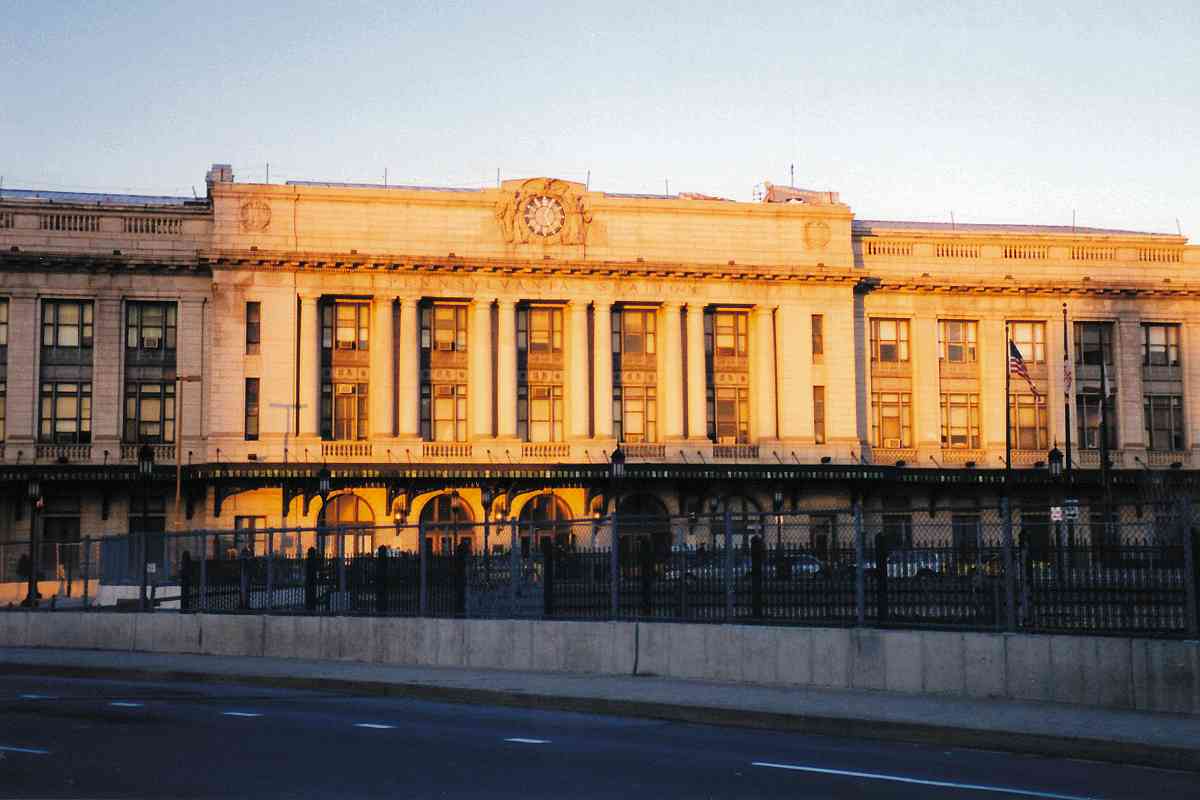
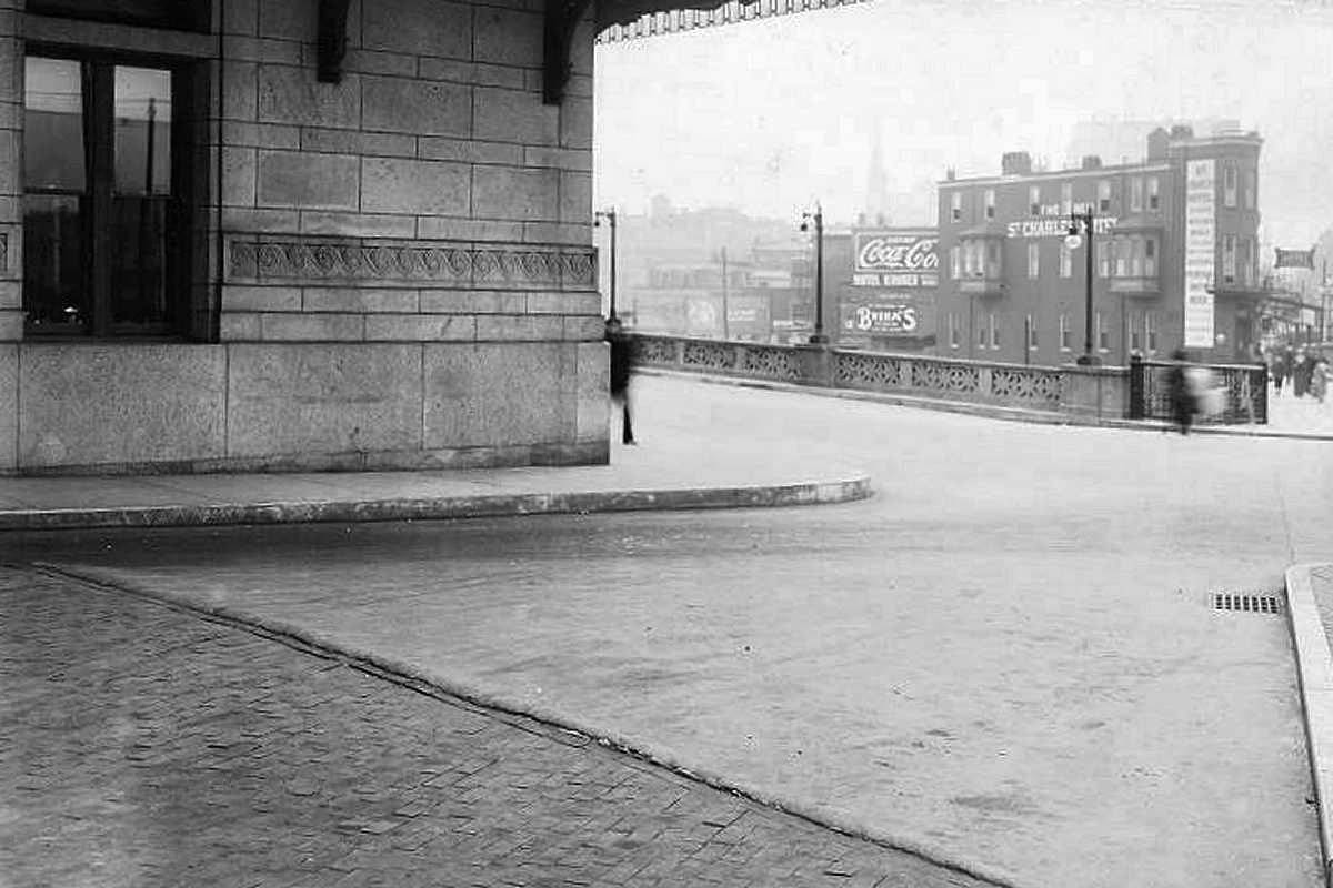
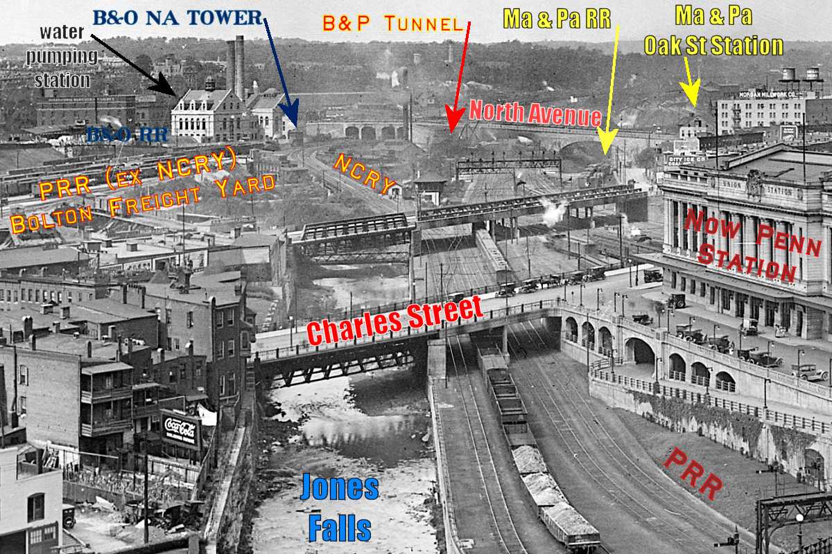
Long before Amtrak, as horse-drawn carriages were giving way to automobiles, the B&P, PW&B, Northern Central, B&O, Western Maryland, and Maryland and Pennsylvania
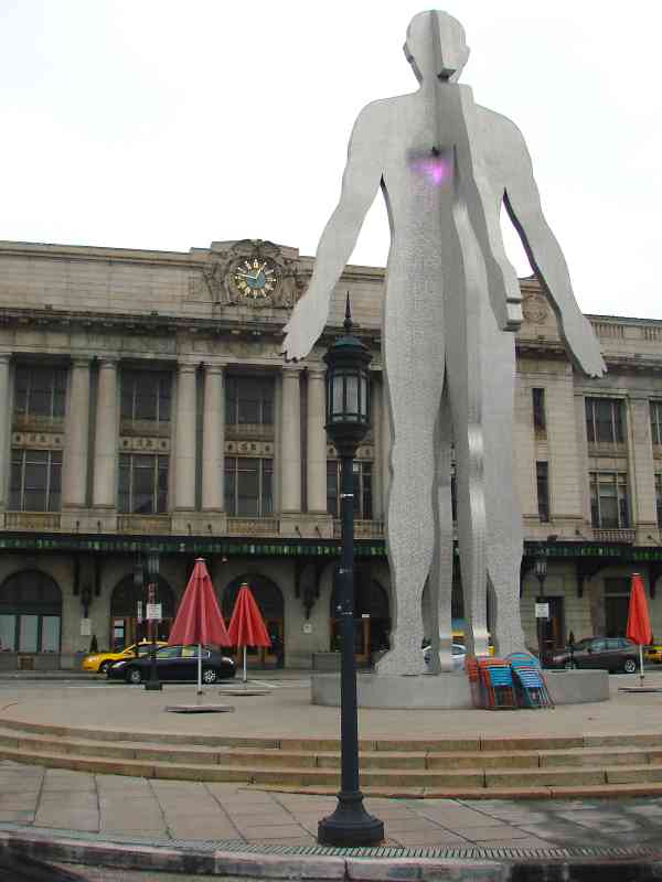
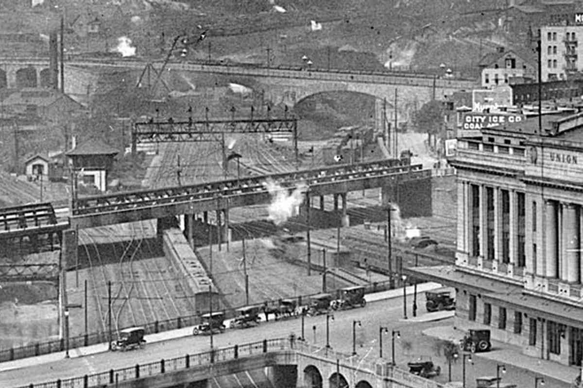
 all had trains zoom rolling in this vicinity. A series of smaller stations gave way in 1911 to the Union Station seen here.

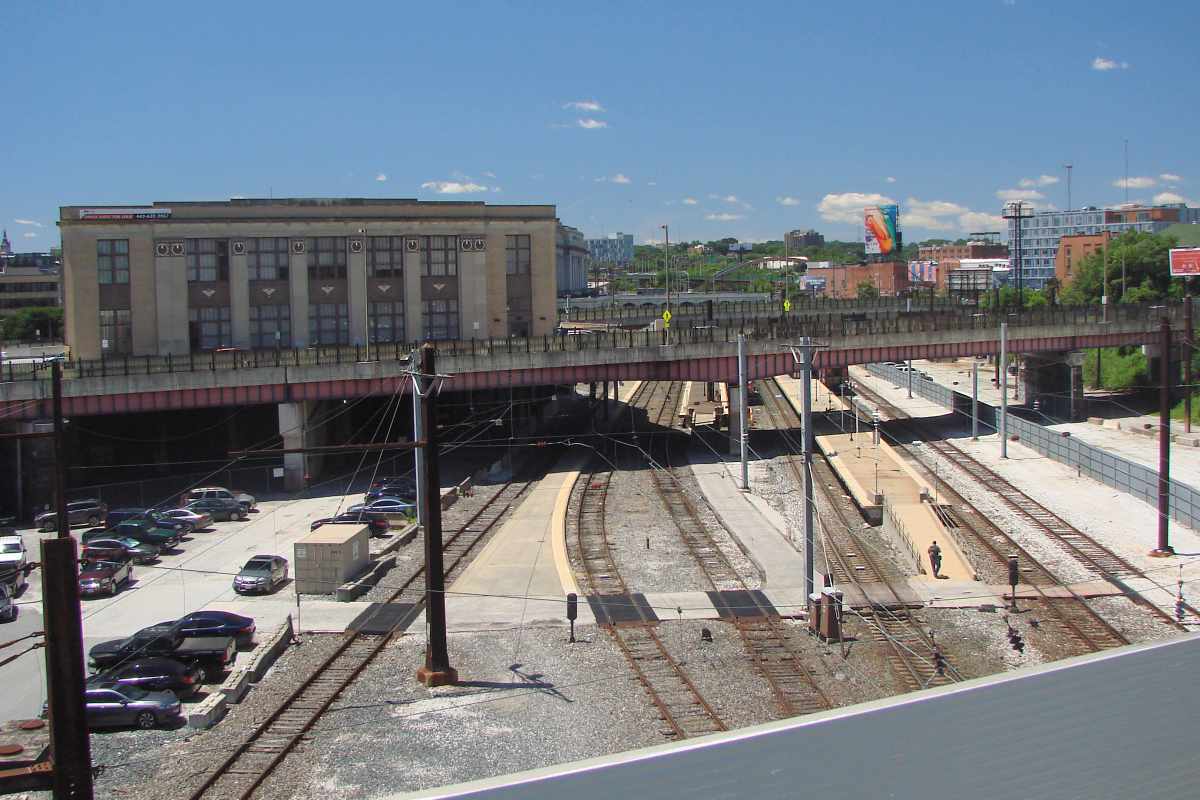
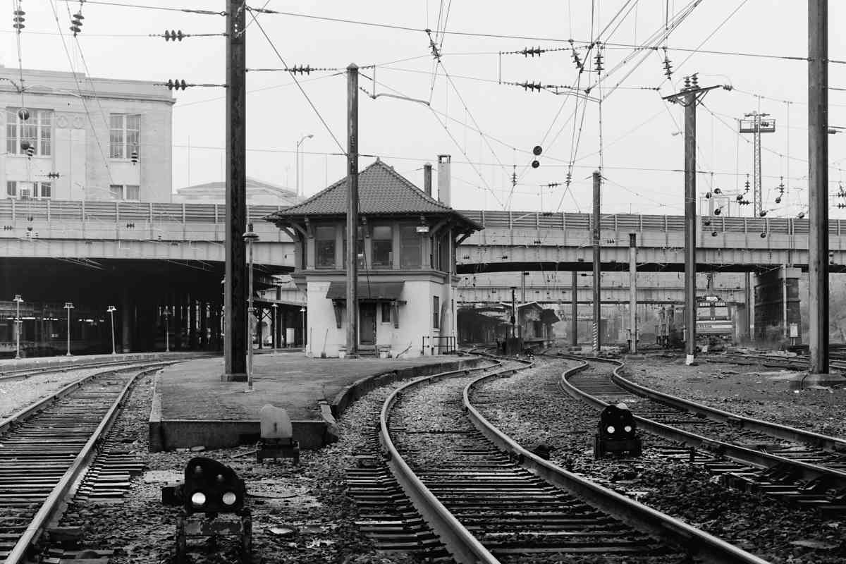
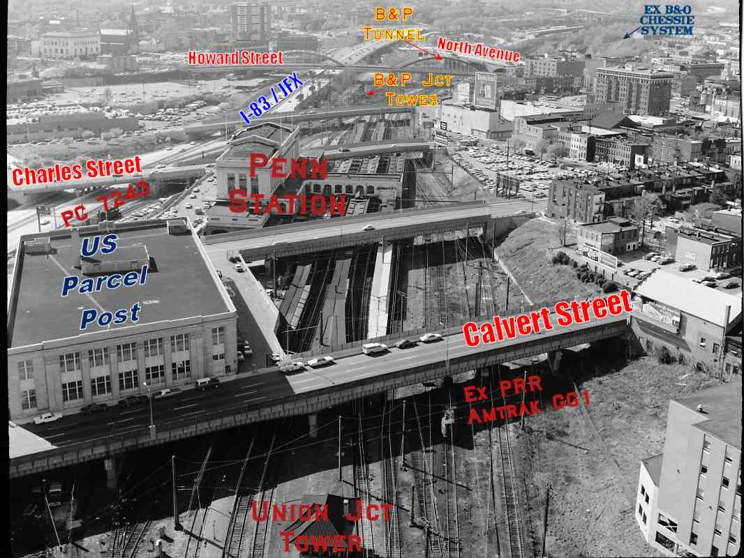
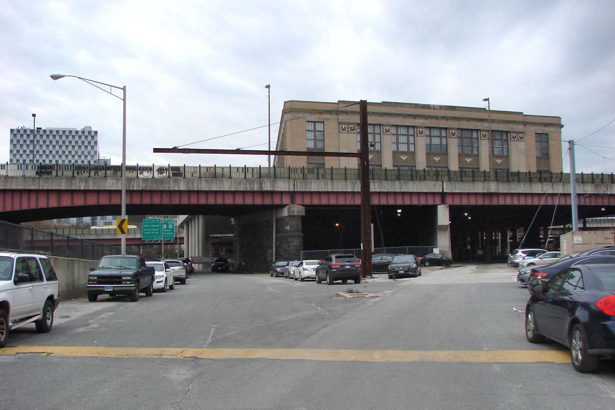
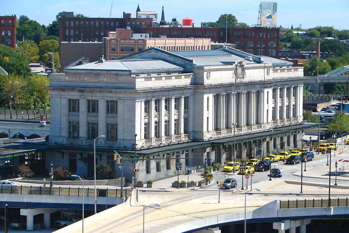
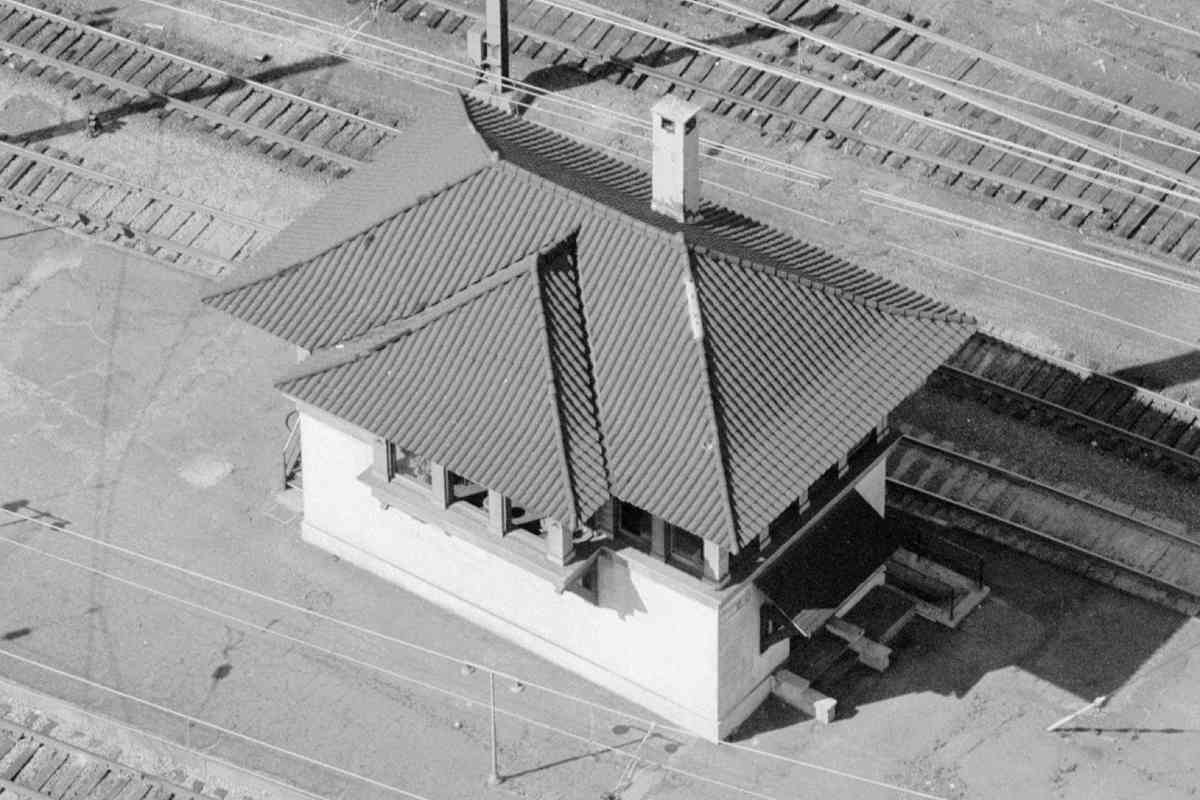
The "Now Penn Station" label on the main photo marks what is considered the front of the building. During 1917, most trains pulled out from behind the station under the power of steam, as seen near center of the zoom view at right. Trains then followed a Z-shaped route into B&P Tunnel near the top left.

Links: source DPC photo, similar 1952?, JFX under construction 1958


departure
Updated late-Dec 2018

Departure
Mile: 95.7 Date: Nov 2018
Ease: B View: NW
Area: B T6:
Map: Ba 35 B 10 Topographic Maps

Jun 1999 A century later, trains were still departing from behind the same structure and using the same route. Instead of steam locomotives during 2018, it's Amtrak's Acela units, such as number 2006. Note the cantilvered, high mounted pedestal signal. Such mounting is uncommon outside Maryland.

Commuter trains, such as the light rail at left, originally arrived at the front of the building, but now join the others in the back.

Links: 1977, new CPL 2022


Amtrak 2016
Updated late-Dec 2018

Amtrak 2016
Mile: 95.8 Date: Oct 2010
Ease: A View: W
Area: B T6:
Map: Ba 35 B 10 Topographic Maps

AMTK 2016 makes like a caboose as it rolls away from the camera bound for Washington, DC. Though Washington is southwest of here, the trip begins in a northwesterly direction, still following the B&P's 1870s route that curves around what was B&O's stronghold in downtown Baltimore. B+P Tower B+P Tower

AMTK 2016 is passing a location on the left known as B&P Junction, site of a Baltimore & Potomac RR interlocking tower (photo at left courtesy Library of Congress) that closed during 1987. The following year it was disassembled and transported to Sykesville, Maryland where it was reassembled (photo at right).

The golden arches in the distance of the main photo do not belong to McDonalds but rather carry Howard Street over the Jones Falls Valley.

Links: LoC source photo, more about the tower's move
Detour: Old Main Line tour of Sykesville at this site


From Howard Street
NEW! late-Dec 2018

From Howard Street
Mile: 95.9 Date: Sep 2016
Ease: A View: SE
Area: B T6:
Map: Ba 35 A 10 Topographic Maps

Looking back to Penn Station from the Howard Street Bridge finds the tracks merge down into two. Howard Street north of the Jones Falls had been known as Oak Street prior to the opening of the Howard Street Bridge.


Howard Street

Howard Street
Mile: 96.0 Date: Sep 2016
Ease: A- View: S
Area: C- T6: 320
Map: Ba 35 A 9 Topographic Maps

Penn Station is off photo left.

Before trains can reach B&P Tunnel, they must find their way over a largely-sequestered Jones Falls and under the colorful Howard Street Bridge. An original ~1870 rail bridge near here was an iron truss that was later moved and reused by the Stewartstown RR in York County, Pennsylvania where as of 2018 it remains extant. plaque

Originally called the Federal Emergency Administration of Public Works, the agency responsible for building the Howard Street bridge over the Jones Falls Valley was renamed the Public Works Administration in 1935 (not to be confused with the Works Progress Administration). It also performed the electrification of the Pennsy line between New York and Washington. Plaques supply details:

Howard Street Bridge,
Approaches and Mt. Royal Overpass
Federal Emergency Administration of Public Works
Project No. Md. 1008-R-14

City Of Baltimore
Department of Public Works
Bureau of Highways
Howard Street Bridge
Approaches And
Mt. Royal Avenue Overpass
Howard W. Jackson
Mayor
Bernard L. Grozier       George Cobb         Herman F. Lucke, Jr.
Chief Engineer         Highways Engineer     Associate Engineer
J.E Greiner Company             Kaufman Construction Co.
Consulting Engineers                         Contractor            
1938

Links: PWA Wikipedia entry, 1977, 1980


Lights

Lights
Mile: 96.0 Date: Sep 2016
Ease: A- View: SW
Area: C- T6:
Map: Ba 35 A 9 Topographic Maps

The route between Penn Station and the tunnel is illuminated by heat lamps for deicing switches and even the catenary. Ice jams switches while icicles and electrified catenary do not go well together. These lamps are found near many switches, especially those close to bodies of water.


<< Previous (northeast) | THIS PAGE: Penn Station | Next (southwest) >>

Or, return to main page

Copyright Notice