


 |
Somerset &
Dorset Joint Railway Moorewood and Old Down Siding |
|
||||
|
||||||
|
||||||
The signal-box at Moorewood (also known as Moorewood Siding) was situated on the main line of the Somerset & Dorset Joint Railway (S&DJR) on the section from Bath Junction to Evercreech Junction in the county of Somerset which was known historically as the 'Bath Extension'. The Somerset and Dorset Railway (S&DR) opened its 'Bath Extension' from Evercreech Junction to Bath in 1874 and then the S&DR became the S&DJR in 1875 when the line was leased jointly by the Midland Railway (MR) and London & South Western Railway (L&SWR). After the Grouping of the railways of Great Britain in 1923 the S&DJR became a Joint line under the control of the London, Midland & Scottish Railway (LMS) and the Southern Railway (SR), who were the successors to the MR and L&SWR respectively. When the railways of Great Britain were nationalised in 1948 the Joint line came under the control of British Railways (Southern Region) (BR(SR)), but in due course control of the old Bath Extension section passed to British Railways (Western Region) (BR(WR)) until the line closed on 6-March-1966.
 |
 |
Moorewood signal-box (SB) had the distinction of being the last SB to be opened on the S&DJR at a location which previously had never had a SB, although it did supersede the small ground-frame (GF) which had controlled the existing Old Down Siding. If one disregards the re-opening in 1920 of the SB at Evercreech New (rebuilt after the previous SB had been destroyed by fire in 1919), then it was also the last completely new SB to be opened anywhere on the S&DJR. It was one of the few S&DJR SBs to be built at a location with no passenger station or junction and also one of the few S&DJR SBs to have been constructed with its lever-frame located at the rear of the box.
Note: the original S&DJR Signal Instruction No 247 for the opening of the new SB called it 'Moorewood Sidings' {plural}, the original SB diagram (and later copies) was labelled 'Moorewood Siding' {singular}, whilst the actual SB nameboard said just 'Moorewood'. All these names appear to have been used in various S&DJR records, but for simplicity the name 'Moorewood' is generally used in RailWest.
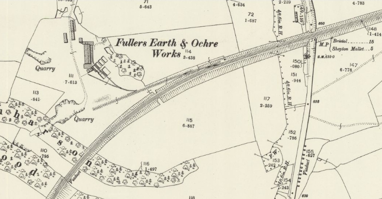
The future Moorewood signal-box (SB) was located approximately 15¼ miles from Bath Junction in an area known as Old Down (roughly a mile west of Chilcompton), where Bridge 59 carried the S&DJR over what is now the A37 road. When the Bath Extension was opened in 1874 the line was single-track throughout with just a few passing-places, but subsequently it was doubled in stages and the section between Chilcompton and Binegar was the first to be upgraded in 1885. Approaching from the north-east the railway passed under Bridge 57 (which carried the current B3139 road) and Bridge 58 (Coalpit Lane), then past the location of some future sidings, over Bridge 59 and then Bridge 60 (a small bridge over a private occupation road which apparently was infilled in 1925), and then across the 6-span Nettlebridge Viaduct (Bridge 61) before continuing south-west towards Binegar. There were never any passenger or public goods facilities at Moorewood and the developement of railway facilities at that location was driven mainly by the traffic needs of local industries, primarily coal mining and quarrying for various minerals. Researching the various changes has been complicated by the fact that older railway records were referenced variously under Chilcompton or Binegar as the neighbouring stations.
In 1895 the S&DJR was approached by Mr CH Meade to provide a siding to his "Fuller's earth and brick and tile works at Old Down near Binegar" (Minute 4487 of the S&DJR Officers' Meeting of 22-October-1895), but subsequently he withdrew because of failing health and the matter was taken forward by his partner Mr Barton (Minute 4668 of the S&DJR Officers' Meeting of 22-April-1897). In due course Minute 5001 of the S&DJR Officers' Meeting of 31-October-1899 recorded a decision to provide a siding at Old Down for the Somerset Fullers Earth and Ochre Company Ltd at an estimated cost to the firm of £385 and annual maintenance charges. Although this work was inspected by the Board of Trade (BoT) in 1900, it would appear that the new Old Down Siding was not opened until 1901. In due course the works area was taken over by the Emborough Stone Company Ltd to handle for the output from their quarries in the valley by the Nettlebridge Viaduct, with a further expansion of the sidings approved in 1920 (Minute 7199 of the S&DJR Officers' Meeting on 20-April-1920). The Emborough Stone Company eventually became part of Roads Reconstruction (1934) Ltd.
In 1907 the S&DJR was approached by Mr C Batey, who had acquired the nearby disused Moorewood Colliery (some distance south-east of the railway at Old Down) and was enquiring about the possibility of a new branch line to serve it; this was costed by the railway's Engineer at approximately £17,000 (Minute 5982 of Officers' Meeting of 24-April-1907) at Mr Batey's expense. At the later meeting of 22-July-1907 it was reported (Minute 6011) that Mr Batey now proposed instead to lay a tramway from the Colliery to a site alongside the S&DJR, where he asked for the provision of sidings to accommodate about 50 wagons, over which he would construct loading screens; this was accepted subject to an agreement on costs (estimated at £2,312) and ongoing interest payments.
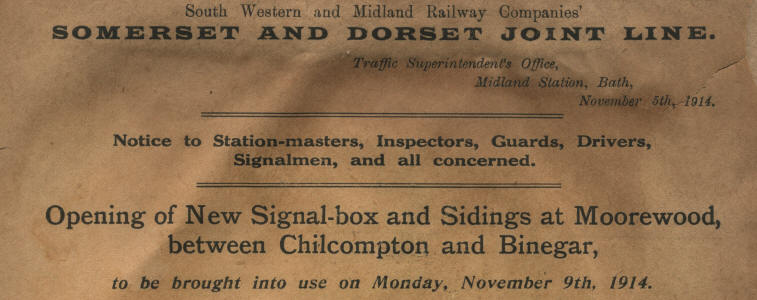
Somewhile later at the Officer's Meeting of 21-April-1913 it was reported that Mr Batey was seeking some modifications to the proposed agreement and the relevant Minute 6610 includes the suggestion that the 1907 scheme should be amended to include '...the provision of a signal-box and a crossover road...'; there is no known record of the original scheme, but one may speculate that perhaps it was to have been just a set of sidings and a GF on the Down line (presumably released from Chilcompton?) similar to the existing Old Down GF. At the Officers' Meeting on 18-July-1913 (Minute 6630) a revised plan was submitted for siding accommodation with an estimated cost of £2,500 and proposed terms for repayment by the Colliery Company, who would be required also to bear the expense of the new SB and the maintenance costs for both the SB and the sidings. The new Moorewood signal-box was opened on 9-November-1914 to control the new sidings (which opened on the same day) and at the same time it superseded the former Old Down GF and thereafter controlled the Up sidings for Emborough Quarries; the new Down Sidings were constructed on the Down side of the line in the area between Bridges 58 and 59 and the new 2-foot narrow-gauge tramway to the Colliery linked to them at the east end near Bridge 58.
South of Old Down on the east side of the A37 road to Gurney Slade lay Cockhill Quarry, which was owned by Clement Dalley & Company Ltd and it was reported at the Officers' Meeting on 29-Oct-1917 (Minute 6972) that an agreement had been reached for "...the construction of a connection with the Moorewood Colliery Sidings..." for an estimated cost to them of £112. There must have been some sort of change to the original proposal, because at the Officers' Meeting of 16-April-1918 (Minute 7015) Dalley & Company asked for "...a siding and connection outside their boundary at the Moorewood Colliery Sidings..." and this was authorised at an estimated cost to them of £200. This connection was at the west end of the existing sidings and was opened on 13-September-1918 [3]; in due course there were several sidings there and a Tarmacadam works, connected to Cockhill Quarry by an aerial ropeway, although precise dates for those additions are not known.
[Note: these additional sidings were labelled as 'Dalley's Sidings' on contemporary maps, but in later years after they had been removed the name was applied erroneously on some maps to the original Colliery sidings. An entry in the Barrington Papers [1] states that Dalley purchased the 'overhead railway' from New Hit at Emborough in 1919-20.]
Moorewood Colliery closed in 1932 and about the same time Dalley and Company went bankrupt and traffic ceased from Cockhill Quarry, which in due course became part of Roads Reconstruction (1934) Ltd. It was reported in 1937 that the former Dalley's sidings were no longer fit for traffic and the connections had been removed; Roads Reconstruction (1934) Ltd acquired an interest in the former Moorewood Colliery sidings so that it could use them to handle their traffic (Private Siding Agreement dated 25-May-1937). In later years therefore the Down sidings appear to have been used mainly for the storage of wagons for quarry traffic and also apparently empty wagons awaiting transfer to the New Rock Colliery sidings at Chilcompton, which had limited capacity. Thereafter Moorewood SB was opened for a single shift only to deal with the Emborough Quarries traffic and also to act as an extra 'block post' between Chilcompton and Binegar when required at busy times. With the gradual run-down of traffic on the S&DJR in the 1960s the Down Sidings were taken out of use on 9-December-1964 and the SB itself was closed on 5-July-1965. Finally the S&DJR itself was closed to all traffic on 6-March-1966 (except for a few short sections retained for goods traffic) and the line through Moorewood was closed completely.
[Note: the history of the various collieries and quarries on the Mendips and the Companies which owned them is a complex subject outside the scope of RailWest. The information given above is just a basic outline where relevant to the S&DJR in the Moorewood area.]
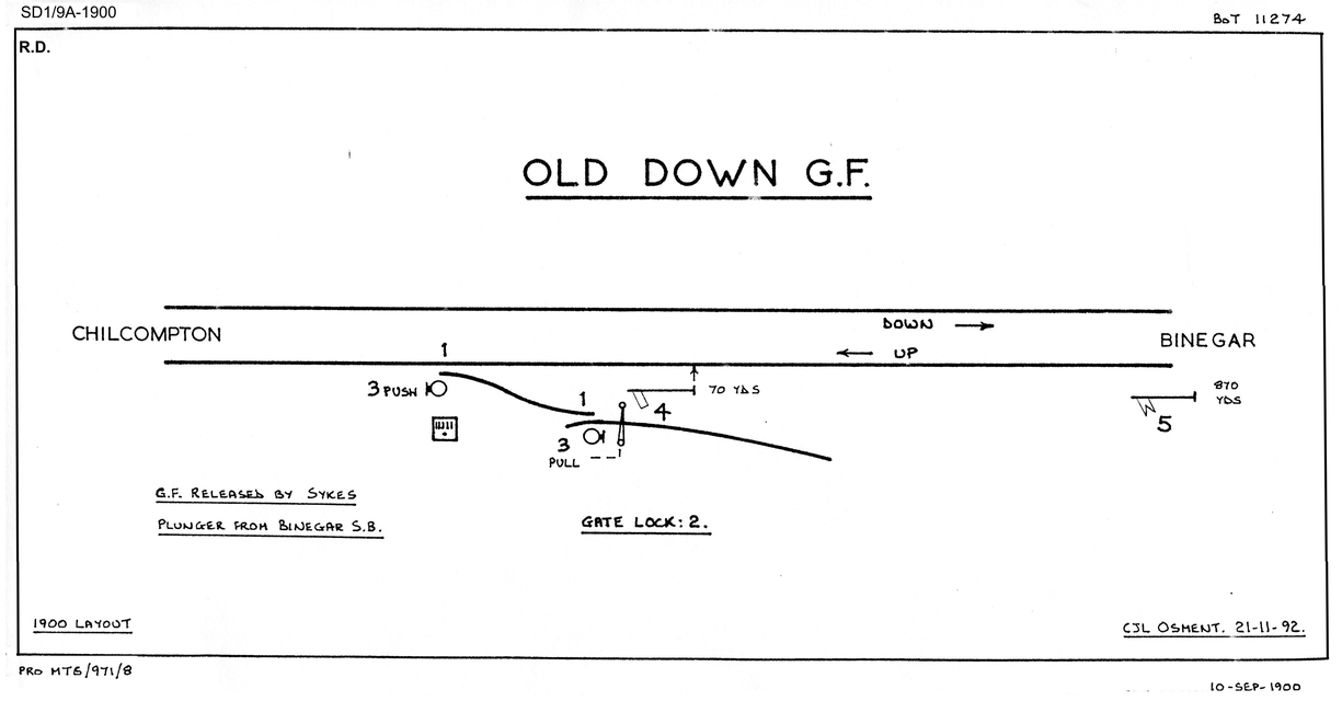
Minute 5001 of the S&DJR Officers' Meeting of 31-October-1899 recorded a decision to provide a siding at Old Down for the Somerset Fullers Earth and Ochre Company Ltd at an estimated cost to the firm of £385 and annual maintenance charges. The new work was inspected for the BoT by Major Pringle on 16-October-1900 (his Report is in The National Archives (TNA) file MT6/971/8) on the same day as the work for Downside Siding but, although the signal diagrams for both locations bore the same date and Downside Siding was opened on 25th October, the late CR Clinker recorded the opening date as 6-May-1901 according to S&DJR Signal Instruction 141 (of which no copy has been sighted). The new siding had a trailing connection into the Up line and was worked by a new Old Down Siding ground-frame (GF); this GF had a 5-lever frame, probably of the Stevens & Sons 'knee' type used at other S&DJR GFs, and was probably housed in a pent-roof wooden hut (typical of contemporary L&SWR GF huts) similar to the one provided at Downside Siding.
[Note: no photographs are known of Old Down GF. However in later years there was a pent-roof hut of a similar style to the one at Downside Siding located next to Moorewood signal-box and one may speculate that was the former GF hut being re-used for other railway purposes.]
 |
 | |
| Old Down Siding GF Diagram 1900 Click diagram for larger image |
Map of Old Down Siding area in 1902 Click picture for larger image |
As the GF was located in the block section between Chilcompton and Binegar, then any train shunting at the GF would protected by the Up Advanced Starting (signal 21) at Binegar, which controlled entry into that block section. However, in accordance with contemporary practice, the GF was provided with its own Home and Distant signals (on the Up line only), which normally stood in the 'off' position when the GF was closed. The GF was locked by a Sykes 'Lift-to-Plunge' instrument located in a box on the outside of the GF and released by a similar instrument in Binegar SB (click here for more information on these instruments). Any train wishing to shunt the siding would be signalled into the block section to Chilcompton as a 'Ballast Train stopping in section'; once the train had passed the Up Advanced Starting at Binegar then lever 21 there would be replaced and subsequently it would become locked normal once the signalman had operated his Sykes instrument to release the GF.
[Note: some commentators state that Old Down Siding GF was released by a key from Binegar SB, but it is considered that this is probably a mis-interpretation of the need for the GF operator to obtain keys for the locks on the bell box and hut door at Old Down Siding; those keys did not unlock the actual GF lever-frame. Details of the Sykes instrument release are taken from official S&DJR records and accord with contemporary practice for such locations.]
In order to shunt the siding the Guard or Shunter, having unlocked the GF, had first to restore the Home and Distant levers (4 and 5) to normal before he could operate the points. Once work had been completed then levers 4 and 5 would be pulled 'off' again, the GF would be closed and re-locked and the Sykes instrument reset, and the train would continue on to Chilcompton. The full operating instructions for Old Down Siding contained in the 1905 edition of the S&DJR Appendix to the Working Timetable (WTT) can be read here; it will be noted therein that, as the signals at Old Down siding were not lit, the siding was to be worked in daylight only, nor was it to be used in the event of a failure of the block working between Binegar and Chilcompton. There was a dedicated telephone circuit between Binegar SB and the Old Down GF hut.
Note: not shown on the signal diagram, but recorded on the map and mentioned in the WTT instructions, was a trap-point located a short distance inside the boundary gate of the sidings and facing outcoming traffic. This trap-point was worked by a local hand-lever; it was normally open, but had to be closed before shunting commenced and then re-opened once shunting had been completed. The GF could not be relocked after use unless the trap-point was detected to be in the open position.
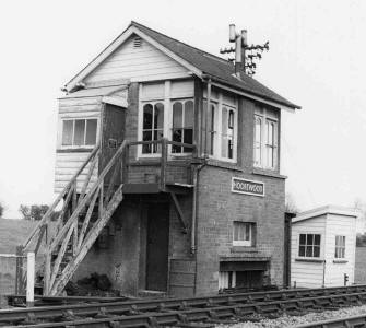
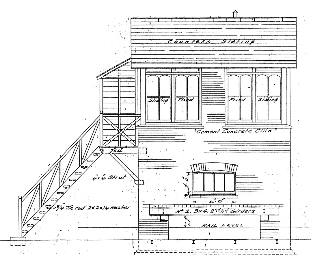
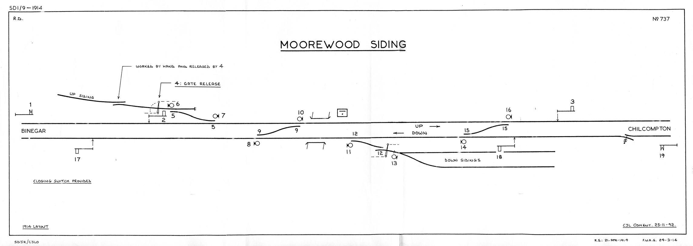
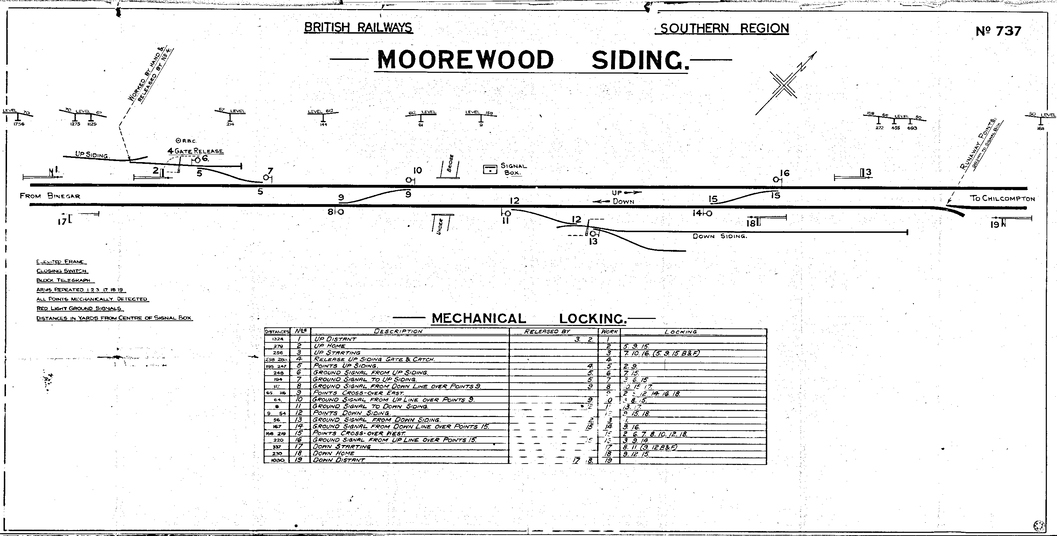
Moorewood signal-box was opened on 9-November-1914 (Signal Instruction 247) and was located on the Up side of the line just east of Bridge 59; it was situated roughly mid-way between the SBs at Chilcompton and Binegar, being 1 mile 272 yards from the former and 1 mile 680 yards from the latter. It was built to the contemporary S&DJR TYPE 3 design as a brick structure with a gable roof, although the gable ends were infilled with horizontal boarding rather than brick as the earlier Type 3 box at Corfe Mullen Junction. Although there are surviving drawings for the construction of the SB which show the lever-frame at the front of the box, in fact it was constructed with the lever-frame at the rear of the box (so the signalman stood back-to-track when operating the lever-frame or block instruments). Old Down GF was closed on the same day and control of the existing siding on the Up line passed to the new SB. The opening of the new SB at Moorewood split the existing Chilcompton - Binegar block section into two new sections Chilcompton - Moorewood - Binegar, both of which were worked by the standard S&DJR 'block telegraph' method. A closing switch was provided at Moorewood so that it could be 'switched out' when not required as a 'block post'.
 |
 |
|
| Front plan of new Signal-box | Moorewood Siding Signal Diagram 1914 | |
| Click either drawing for a larger image | ||
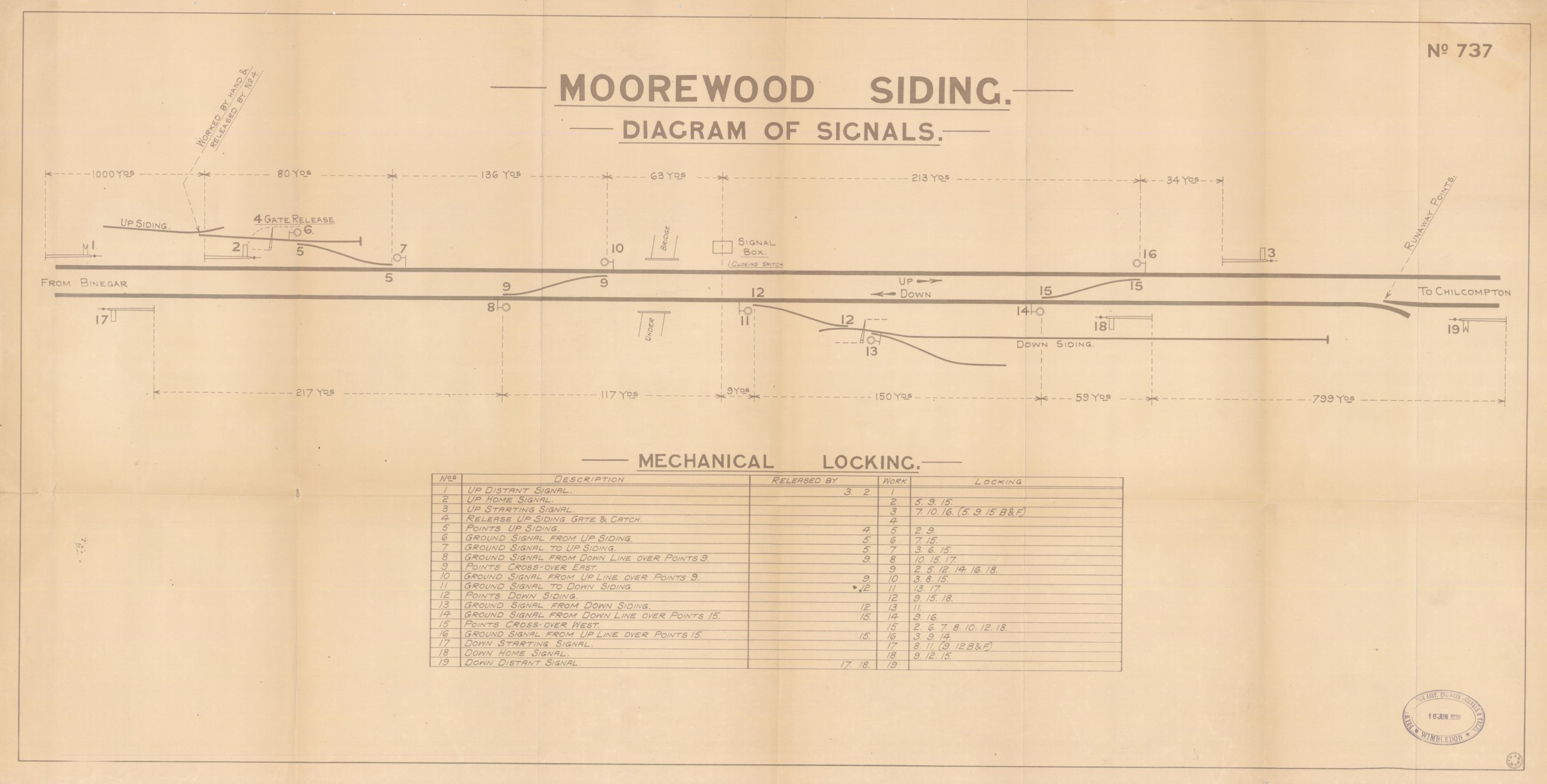
The SB was equipped with an interlocking frame of the Stevens & Sons 'direct tappet' pattern with 19 levers at 4.1/8" centres (see Note 1 below), all of which were in use; the levers would have been fitted with lever description plates of the contemporary L&SWR cast brass design, for which an order was placed on 29-April-1913 (see Note 2 below). The diagram shown above is based on the original S&DJR signal diagram which was drawn by 'F.W.A.G' on 24-March-1914 in preparation for the new work and allocated the identification number 737 - click here to see a photograph of the original drawing (sadly a rather unsharp image). The new installation had a fairly straight-forward layout with trailing connections to the (existing) Up and (new) Down sidings and two crossover roads (East and West); there were a total of 6 running signals (Distant, Home and Starting in each direction) and 8 ground signals (2 for each pair of points). Lever 4 bolted the boundary gate on the Up siding and also the additional trap-point inside the gate, but there was never any control over the gate on the Down sidings (it is not known why the arrangements differed for the two gates).
[Note 1: by 1914 Stevens & Sons had
closed down and the L&SWR was buying frames for the S&DJR made to that
design by other manufacturers, but it is not known who supplied the frame
for Moorewood.
Note 2: it is not known if any of the
original lever description plates were ever replaced by the later SR
'painted oval' type, but there is no obvious reason why that would have
happened other than in the case of damage. It is a matter for speculation whether, when levers 11, 12 and 13 became
spares in 1964, BR(W) simply removed the old plates or replaced them by new 'blank'
ones of their own design (as happened at Midford
in 1960).]
One additional feature of the new installation was the insertion of a new spring-loaded trailing 'runaway catch-point' in the Down line in rear of the Down Home (signal 18). According to the initial 1914 diagram this catch-point was to be 450 yards in rear of the Down Home and 350 yards inside the Down Distant (signal 19), but that proposal must have been have modified as Signal Instruction 247 states that the catch-point was just 48 yards inside the Down Distant, hence 752 yards in rear of the Down Home and 979 yards from the SB (quoted as 983 yards on a BR-era diagram). The Signal Instruction also stated that "...the position is indicated by the word 'Switch' painted in black letters on the small box covering the handle of the Runaway Catch Points"; one may speculate whether in due course (as happened with the catch-points at Midsomer Norton, Masbury and Winsor Hill) the cover was removed and replaced by a small 'CATCH POINTS' notice on a nearby post. Curiously though in the 1933 WTT Appendix the catch-point is listed as being just 525 yards in rear of the Down Home, which roughly matches the distances quoted in the same Appendix for similar catch-points at Masbury (520 yards), Midsomer Norton (540 yards) and Winsor Hill (540 yards). It should be noted that Minute 7786 of the S&D Officer's Conference on 23-April-1926 recorded a decision that "...in consequence of the increased loading of goods trains...owing to the use of the 2-8-0 type of engine..." the catch-points at Midsomer Norton, Masbury and Winsor Hill would be set back to give a clearance of no less than 500 yards, but made no mention of Moorewood; that would suggest that at Moorewood the catch-point was already sufficiently far in rear of the Down Home, but of course that does not confirm the actual distance.
Moorewood was one of those S&DJR signalling installations which appears to have changed very little throughout its existence, although records are scarce. The signalling was unaffected by the addition of the sidings for Dalley & Company circa-1918, as they were accessed from the existing Down Sidings and never appeared on any versions of the signal diagram. Photographic coverage of the Moorewood area is quite limited, but - judging from what survived into the 1960s - it would appear that all the main running signals originally had lower-quadrant (LQ) arms on lattice posts. By BR days at least the Down Starting (signal 17) was fitted with a quadrant-shaped 'sighting plate' behind its arm. The situation with regard to the ground signals is a little unclear, given that by mid-1910 the S&DJR had already used a new pattern of semaphore ground signal at Midsomer Norton (Signal Instruction 216) and therefore might have been expected to use that type for a new installation in 1914, yet shunt signal 13 was still one of the older 'drop flap' pattern when photographed in 1958 (click here to see image). A 1961 photograph shows ground signals 10 and 14 to be examples of the SR 'half-disc' type, but images of the other ground signals remain elusive.
At the S&D Joint Committee meeting of 16-January-1924 (Minute 7586) a proposal was submitted to replace the 15' post of the Down Home (signal 18) by one of 30' height, as the view of it for approaching drivers was rather obscured by an over-bridge (presumably Bridge 58) and the curvature of the line. This was agreed at an estimated cost of £28 and the replacement signal was brought into use at 6:00am on 30-March-1924 at 6:00am (Signal Instruction 274). At some unknown date the Down Distant (signal 19) was renewed as an upper-quadrant (UQ) arm on a SR-type tail-built post; this was the only running signal at Moorewood known to have been changed to a UQ arm and also the only one known to have changed from a lattice post. Signal Instruction 387 advised of alterations to two ground signals in November 1941:- on 16th of that month ground signal 8 was to be moved 7 yards further away from the SB, then a week later on 23rd ground signal 10 was to be moved 8 yards closer to the SB. One may speculate that perhaps these changes arose as the result of the west crossover (points 9) being relayed at a slightly greater length? (Note: a copy of the signal diagram produced in early BR days still shows the original distances for those ground signals; was that because the changes never took place, or simply that the relevant diagram alterations were over-looked in the pressure of war-time operation?) It should be noted also that, although all the known official diagrams for Moorewood place ground signal 11 outside of the Down line, the late George Pryer [2] recorded is as being in the 'six-foot' between the Down and Up lines; it is not known if this was an error in his records, or the result of an actual relocation for which no known record exists.
A copy exists of the signal diagram which was rubber-stamped 16-June-1930 and there is also a copy of the diagram from the BR(SR) period, which sadly is undated but is probably part of a collection of S&DJR signal diagrams which were re-labelled and reprinted circa-1948. Both diagrams are shown below, together with a copy of the 'dog chart' for the mechanical interlocking. There appears to be no significant difference between the 1914, 1930 and BR(SR) versions other than in some of the ancillary detail contained in them and the way in which it was presented. For example, the BR(SR) version includes the information that all six of the main running signals had arm repeaters in the SB, which is a rather more comprehensive provision that at some other S&DJR SBs especially given that the Down Home was only 230 yards from the SB and ought to have been quite clearly visible.
 |
 |
 |
||
| Moorewood Signal Diagram 1930 | Moorewood interlocking 'dog-chart' | Moorewood Signal Diagram circa-1948 | ||
| Click any drawing for a larger image | ||||
It is reported [4] that by the mid-1960s the Emborough Quarries traffic had been switched to road trasnport, but it is not known when, or if, the Up sidings were taken officially out of use. The Down Sidings were taken out of use on 9-December-1964 when points 12 and shunt signals 11 and 13 were recovered (BR(S) Weekly Notice P/EW46), after which the relevant levers in the SB became spares. The SB at Chilcompton was closed on 11-April-1965, after which the block section northwards became Moorewood - Midsomer Norton. Moorewood SB itself was closed on 5-July-1965 (BR(S) Weekly Notice P/EW24); all the signals and discs were recovered and the points spiked, clipped and padlocked in their normal positions pending recovery in due course. So the S&DJR in the Moorewood area reverted to being simply part of a double-track line in the section between Midsomer Norton and Binegar, not too dissimilar to its origins in the 1874 Bath Extension, until the line was closed on 6-March-1966.
Postcript...
The demolition train worked through the Moorewood area in June 1968, by which time the signal-box had been demolished already, but the former crossover roads and connection to the Up Sidings were still in place. The Down Sidings do not appear in a photograph taken on 8-March-1968 (although it is possible that they were merely hidden by the long grass!), but it is not known exactly when they were lifted. It is reported [4] that the Up Sidings were lifted by the site owners in 1969 with the intention of donating the materials to a heritage railway, but apparently the the track was stolen while awaiting collection.
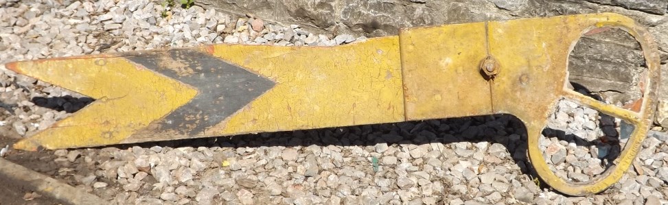
In later years both Bridge 57 and Bridge 58 were demolished for road improvements and the cutting between those two bridges was infilled and returned to meadows. The trackbed between Bridge 58 and Bridge 59 remained relatively clear in 2015 and appeared to be in agricultural use for grazing. The deck was removed from Bridge 59 but the abutments still remain despite restricting the width of the A39 road. Nettlebridge Viaduct is still standing, but without public access. The base of the former SB still remained in the undergrowth at the side of the embankment adjacent to Bridge 59 in 2015 (click here to see image). One item known to have survived from the signalling installation at Moorewood is the wooden LQ arm from the Up Distant (click here to see image), which is now in the possession of the Somerset & Dorset Railway Heritage Trust; the wooden 'blade' is on display in their Museum at Midsomer Norton South station, whilst the spectacle plate casting forms part of the Up Distant for their signal-box.
© CJL Osment 2023-2026
Thanks to Mike Arlett, Steve Ehrlicher, Tony Cooke and Peter Russell for additional material. Moorewood SB photo courtesy Colin Caddy collection.
References
|
|
|||||||
| © West Country Railway Archives 2023 Page last updated: 23 June 2026 |
URL:
E-Mail: |
||||||


