


This page contains links to maps, reports, & documents on Hamilton’s transit history.
HSR Jan 2025 System Map (external link)
HSR Dec 2019 System Map (external link)
HSR Jan 2015 System Map (external link)
HSR Sep 2012 System Map (external link)
HSR Mar 2012 System Map (external link)
HSR Jan 2011 System Map (external link)
HSR Fall 2009 System Map (external link)
HSR Mar 2006 System Map (external link)
HSR Nov 2003 System Map (external link)
HSR Jan 2003 System Map (external link)
HSR Fall 1999 System Map (external link)
HSR Sep 1993 System Map (external link)
HSR Sep 1991 System Map (external link)
HSR Sep 1989 System Map (external link)
HSR Mar 1988 System Map (external link)
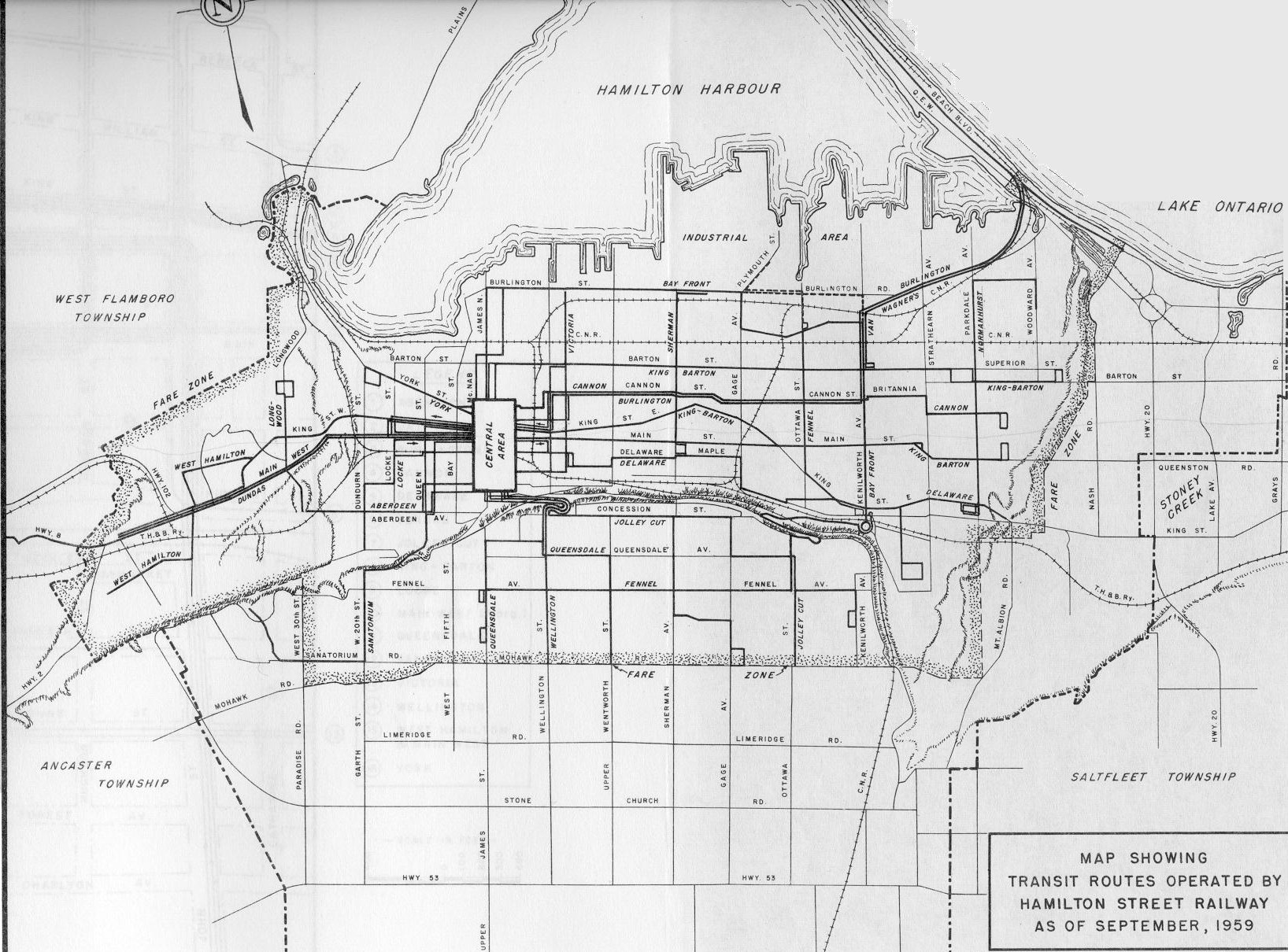
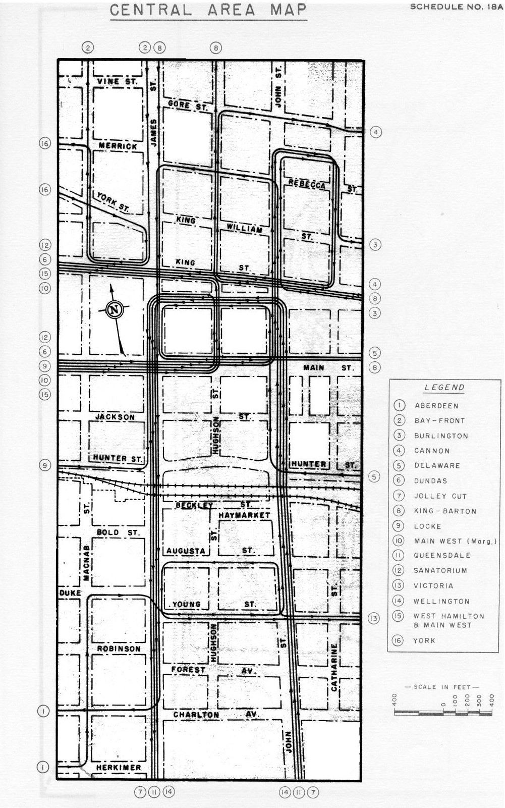
HSR 1959 System Map, Downtown Core Enlargement
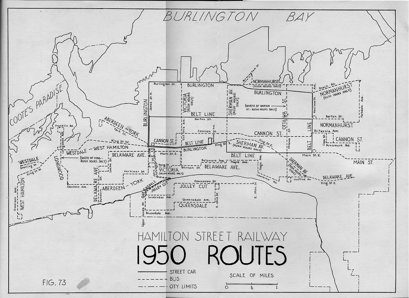
HSR 1950 System Map (By Stuart Westland)
HSR 1940 Streetcar Network (Google Map)
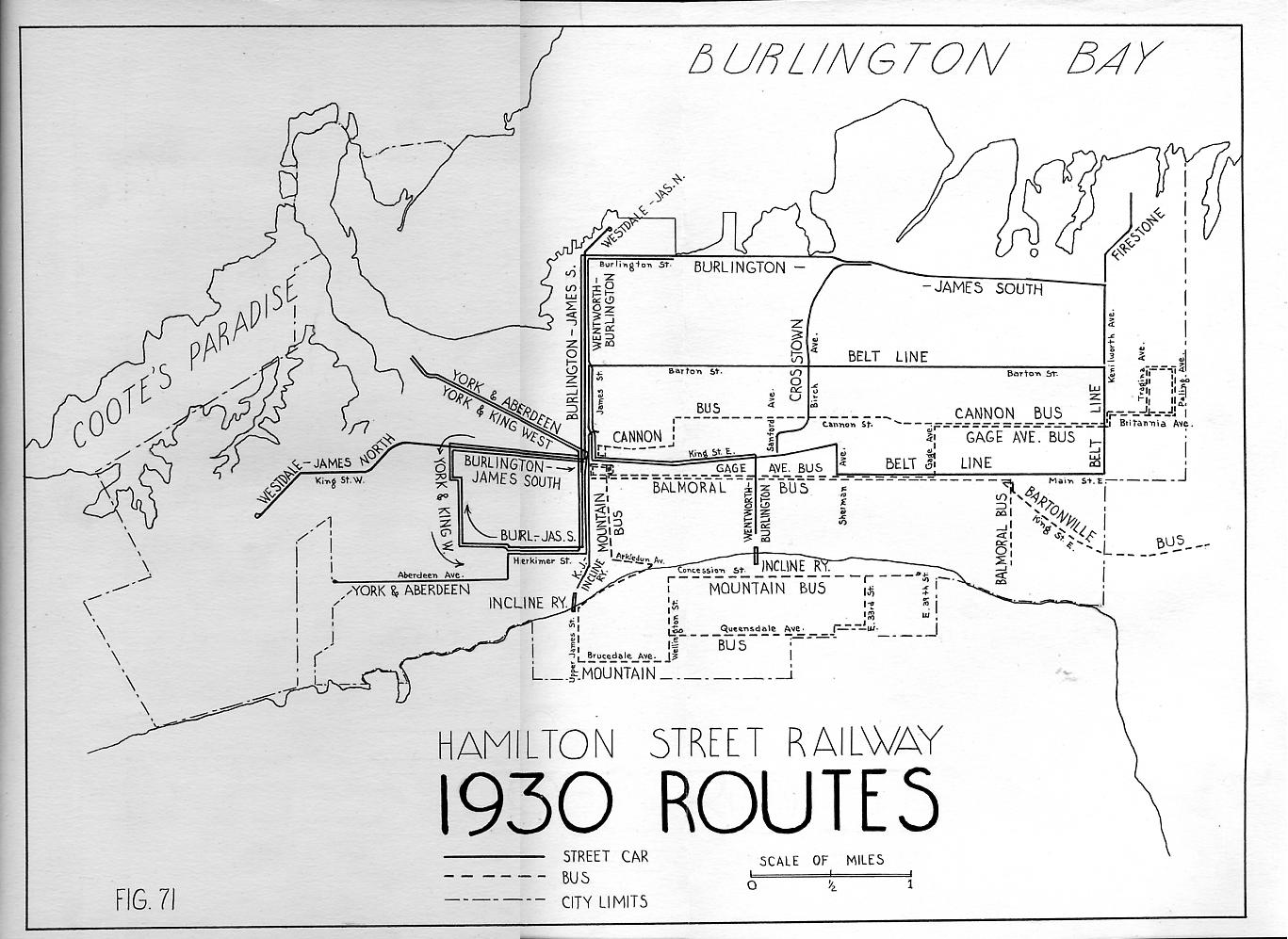
HSR 1930 System Map (By Stuart Westland)
1913 Hamilton Map (with HSR & Radial tracks) (external link)
HSR 1912 System Map (Google Map)
1882 Hamilton Map (with HSR tracks) (external link)
1876 Hamilton Map (with HSR tracks) (external link)
HSR 1874 System Map (Google Map)
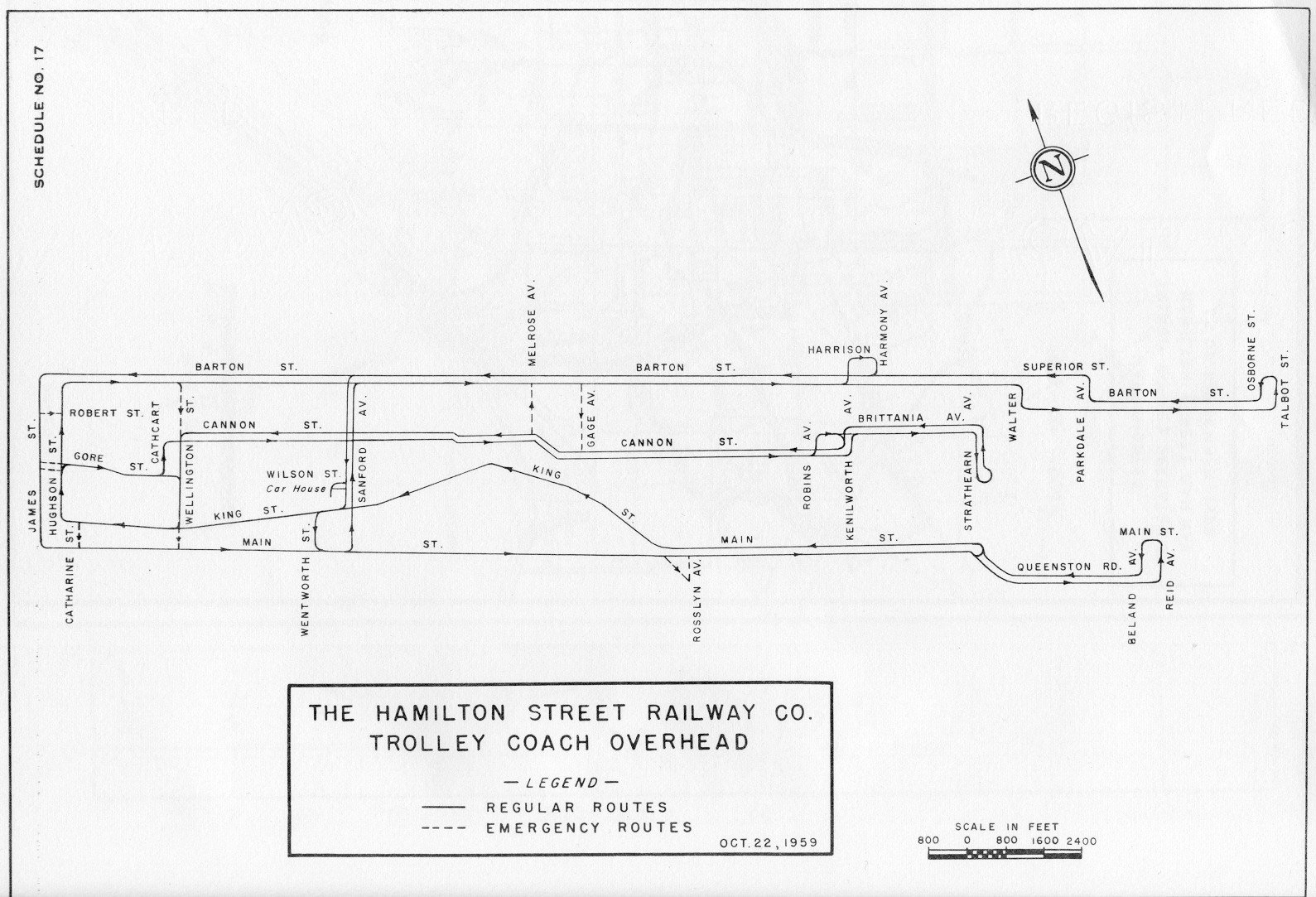
HSR 1959 Trolley Wire Map (.jpg, 359KB)
Hamilton Radial Network, 1916 (Google Map)
Miscellaneous Documents from the HSR, CCL, Incline and Radial Railways
Now, Canada Coach Lines Can Get You to Any of These Places ... By Elevator (external link)
Hamilton Area Rapid Transit Study Physical Feasibility Report (external link)
Hamilton Transit Study (external link)
Hamilton Transit Study: Phase II (external link)
Major Street System for the City of Hamilton (external link)
HSR Maintenance and Storage Facilities Investigation (external link)
Report on Present and Future Space Requirements at the Wentworth Street Bus Depot (external link)
Transportation for the Handicapped and Aged (external link)
Transit Fares for Seniors: a Framework for the Future (external link)
Transit Service Proposals : Stoney Creek East (external link)
Hamilton-Wentworth Regional Official Plan : Transportation Policy Paper (external link)
Hamilton-Wentworth Review Commission Transportation Services Component (external link)
Hamilton Street Railway Company 1991 Transit Service Plan : Options for Discussion (external link)
Hamilton-Wentworth Regional Transit System : 1983 Five Year Strategic Plan (external link)
Transportation a Substudy of the Regional Official Plan (1975) (external links)
1974 Hamilton-Wentworth Regional Transit Assumption Study (external links)
Marketing Study of New Corporate Names for the Hamilton Street Railway (external link)
HSR, 1874-1999: Celebrating 125 Years of Service (external link)
HSR 115 Years: Wentworth Street Transportation Centre (external link)
Farebox Performance Assessment: Hamilton Street Railway (external link)
HSR Announces Public Consultation on Vehicle Alternatives (external link)
HSR Announces Study to Look at Options for Public Transit (external link)
Maintenance and Storage Facilities Investigation (external link)
Report on Present and Future Space Requirements at the Wentworth Street Bus Depot (external link)
Disabled and Aged Regional Transit System Annual reports (external links)
Annual Report on the Hamilton Street Railway Company & The Canada Coach Lines (external links)
Bus Beat (external links)
GO Transit. Government of Ontario Transit; a new approach to urban transportation (external link)
People on the GO - Riding Patterns and Trends on the Government of Ontario's GO Transit Rail Service (external links)
GO Transit Annual reports (external links)


